Procedia - Social and Behavioral Sciences 57 ( 2012 ) 426 – 431
1877-0428 © 2012 Published by Elsevier Ltd. Selection and/or peer-review under responsibility of the Asia Pacific Business Innovation and Technology Management Society (APBITM)
doi: 10.1016/j.sbspro.2012.09.1207
International Conference on Asia Pacific Business Innovation and
Technology Management
Shortest Path Problem for Public Transportation Using GPS
and Map Service
Esther Irawati Setiawan
b*, Gunawan
b†,Indra Maryati
a,b‡, Joan Santoso
a,b§, and
Rossy Prabowo Chandra
ba
Information Technology Department, Sekolah Tinggi Teknik Surabaya, Ngagel Jaya Tengah 73-77 Surabaya 60284, Indonesia b
Computer Engineering Department, Sekolah Tinggi Teknik Surabaya, Ngagel Jaya Tengah 73-77 Surabaya 60284, Indonesia
Abstract
Area of a city tends to be larger. Along with the expansion of the scope of a town, public cruising range will be more widespread, so the ability to remember the location of the nearest public facility will be decreased. Another reason underlying the need for information about the locations of public facilities is the requirement to be able to use time efficiently and effectively. Given the information as appropriate, someone will be able to shorten the time it can be used to run other activities that are not less important.
The use of different types of vehicles between some people with the other also becomes an additional problem. Someone who accustomed to using private vehicles in daily activities will have difficulty in finding a facility when using public transportation. This is happen because there are many types of public transportation that can be used. From that problem which described, appears a need of some applications that can provide information about the location of public facilities and public transportation routes that can be used. Applications that need will be felt more useful if it can be accessed anytime, anywhere, and by using a device that has been familiar.
This research will develop an application that can provide information about the location of public facilities and public transportation routes that can be used.
© 2012 Published by Elsevier Ltd. Selection and/or peer-review under responsibility of the Asia Pacific
Business Innovation and Technology Management Society (APBITM).”
Keywords: Shortest Routing Problem; A* Algorithm; Map Service; Public Facilities;Technology Innovation; Android Phone
1. Introduction
Area of a city tends to be larger, not only the area but population also increase every year, especially in Surabaya city which is the second largest city in Indonesia. Along with the expansion of Surabaya city, people need more information about the location of a facility. The absence of detailed information about the location of causing trouble when someone needs to find a particular facility. The level of
© 2012 Published by Elsevier Ltd. Selection and/or peer-review under responsibility of the Asia Pacific Business Innovation and Technology Management Society (APBITM)Open access under CC BY-NC-ND license.
difficulty will be increasingly felt as the need to find a particular facility is urgent. The presence of a fairly complete source of information, difficulty finding a location can be reduced drastically. The ability to remember the location of the nearest public facility will be decreased. This is one reason why people need some information about the locations of public facilities are often required in daily life.
Information that search by user depends on many factors, for example job, age, gender, nationality, etc. For example a tourist needs information about nearest police station. Although this type of facility being search by a person may not be the same as the others, it can be drawn any conclusions about the types of facilities that are often search after by many people. One type of facilities that are often search by a person is ATM.
In addition to the need for facility location information, the need for a route that can be taken to the location also be a pretty important thing. Given the obvious route, one can make savings both in terms of time or cost in the location of the facility to search for. Necessary route there are two kinds of routes that can be reached by private vehicles and routes that can be reached by public transportation. The existence of two kinds of routes is needed because the people in Indonesia, especially in Surabaya not all have their vehicle. The number of users a wide range of public transportation is also one of the reasons it needs a public transportation route.
Types of public transportation in Indonesia, especially in Surabaya, there were all kinds. The types of public transportation available and frequently used include taxi, bus, or bemo lyn, and angguna. Of the four types of public transportation, the city bus and lyn is a common type of vehicle which is pretty much used various circles of society.
Buses and lyn is a common type of vehicle that can only pass a pre-determined route. To reach a destination using the bus or lyn, the user is required to know the route. Because the number of buses available in Surabaya city is limited, people are more likely to use lyn public transportation to travel in the city. Use of buses is more widely used if going into areas that are far away from the city center, such as to a particular terminal or remote areas. Use of lyn to reach a location can be done by knowing the route the streets where a lyn. If the destination you are looking for cannot be pass by a lyn, and then the user must change into another lyn. Substitution lyn are considered troublesome because the user has to memorize the various routes or types of lyn to achieve a destination. Apart from having to memorize the various routes taken by each lyn, users also need to know the position where he must come down from a lyn to change to another.
Of these reasons, one solution that can be used is the provision of an application which can provide information about the exact location of public facilities to the user. Location of public facilities that can be known is the location of hospitals, pharmacies, banks, and ATM. In addition, the application also comes with the route and type of lyn can use to get to the location. In order to improve the efficiency and effectiveness of users in obtaining the required information, then making the application is done on a mobile/cell phones have become an integral part in everyday life. The target of the users of these applications is the general public in Indonesia, particularly in the area of Surabaya.
2. Basic Theory
Optimum A * algorithm [1] is used to search for the nearest public transportation route. A * algorithm is an algorithm that has been enriched with a heuristic function. The heuristic function is used as an optimization algorithm that makes this algorithm is superior when compared with other algorithms.
A * algorithm is similar to the BFS [1], as it will visit in depth for the selected node is considered the best. If the node was visited not lead to a solution, it will return to the previous node to destination node find other, more promising. Process back to the previous node will recur if not find the destination node that leads to the solution.
Merge Sort algorithm [2] is one of the algorithms used to perform the process of sorting or sorting data. This algorithm was invented by John von Neumann in 1945. Merge Sort algorithm using divide and conquer method for sorting the data [2]. All data will be broken down and divided up until only one number left, and data sorting process will be done.
Google provides the services that can be used to determine the distance, where the position of a location, as well as generating a map. The service can be used using web service and XML. Web service is a method of communication between two electronic devices over the Web [4]. Web service description using SOAP messages, typically conveyed using HTTP with an XML serialization in conjunction with other Web-related standards. Service from Google Direction provides an easy to find the distance from one location to another. Service from Google Geocoding [5] is used to obtain the location coordinates of latitude and longitude of a place. Service of the Google Static Maps can be used to generate a map. [6]
3. Application Architecture and Design
Based on the issues that have been described before, it will be applications that can help a person get information about the location of the nearest facility from the user's position. Applications are made to be run on mobile phone. This application will provide details of a location of the search facilities. In addition to showing the location of the nearest location that are looking for, this application also gives some simple information such as name, address, and telephone number for this type of facility.
Application is made will also provide additional information about route that can be taken by user from an initial position to the destination. There are two kinds of routes, route for private vehicles and routes for public transportation. The results of the routes depends on user needs, if the user chooses to use a private vehicle will be given a route that can be taken by a private vehicle, if the user selects a public vehicle will be given the route that can traveled by public transportation, lyn.
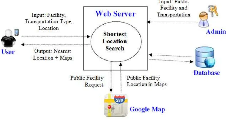
Applications that are made are of two kinds, the application server and mobile applications. A server application is a web server. Mobile applications in the form of applications that use via mobile phones based on Android. Requested input from the user system is the location, type of facilities sought, and public transportation routes.
Fig. 1. System Architecture
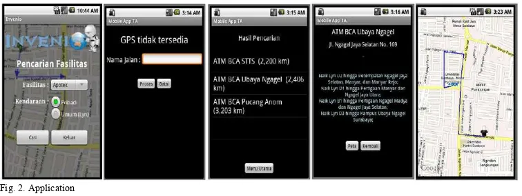
Fig. 2. Application
3.1.Server Application
Application server is the center of all the processes that occur in this application. Application server is built on a web server, which can be accessed at any time provided that the user can connect to the internet connection. Application server is to search a list of locations that the user requested the nearest facility. Processes that occur in the server covers the process of receiving input from the user mobile applications, the process of finding the location of nearby public facilities, the lyn types search process that can be used, and the process of sending the information to the user mobile applications.
Application Server in charge of doing all the processes related to search nearby locations. Processes that occur at the application server includes the process of receiving a request from the mobile application, the process of finding the nearest location and route can be reached, the search process lyn types that can be used to get to the location, and the utilization of the Google Maps service. The process of receiving the request used to obtain data that the user submits the request. The process of finding the nearest location and route consists of two parts, the search facility and the process to get the nearest facility. The search process will yield information about the existing facilities within reach. The process of getting the nearest facility is used to determine the location of the nearest facility anywhere from the user's position at that time. Lyn type search process done after getting the route. The process of utilization of the Google Maps service is used for data input.
3.2.Mobile Application
Mobile application is an application that will be used by users to request information and displays the results. This mobile application will be made on a mobile phone based on Android. A process occurring in the mobile application covers the process of entering input, the process of obtaining user location, the delivery request, and the admissions process and display the result of information from the application server.
Mobile applications are used by the user via the mobile phone to search for the nearest location request. The process that occurs in the mobile application includes a request made by the user, the process of sending the request, and displays the results of the information. Processes user requests are used to enter user data location and type of facilities who want to look for. The process of sending a request made in sending the information sought by users. The process of displaying the information consists of two parts, namely the process of displaying the results and process maps. The process of displaying the results is used to display the detail information of search results. The process used to obtain maps containing route maps that can be taken to reach the destination location.
4. Test Case
Test case is made in application server, which testing menu in the server will generate a list of the nearest facility, that contains a route map that can be taken, as well as public transportation routes if the user chose to use public transportation. User is asked to fill in all necessary data manually and user must enter location manually because the application server does not have GPS facility.
Table 1 First Testing
Input Output
Vehicle Type = Private Vehicle 1. ATM BCA RMI – 0.449 km 2. ATM BCASTTS – 0.691 km 3. ATM BCA Ubaya Ngagel – 0.897 km 4.ATM BCA Pucang – 2.02 km Source Location = Manyar Rejo Street
Facility = ATM BCA Application = Server
Fig. 3.First Application Testing in Google Map
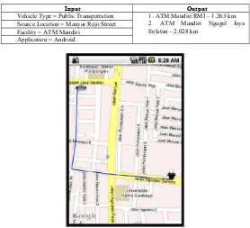
Test case is made in mobile application. The second trial was conducted to find the nearest ATM Mandiri. User's current position is at Manyar Rejo Street, and choosing to use public transportation. Trial results can be seen in Table 2, and the resulting map image can be seen in Figure 4.
Table 2 Second Testing
Input Output
Vehicle Type = Public Transportation 1. ATM Mandiri RMI – 1.263 km 2. ATM Mandiri Ngagel Jaya Selatan – 2.028 km
Source Location = Manyar Rejo Street Facility = ATM Mandiri
Application = Android
At this second trial, in addition to displaying detailed information, the application also returns a list of public transportation that can be used to reach the site. Because this testing is use Android device, the position of the user obtain from GPS in the Android mobile device. The Results of the second testing is public transportation routes are that generated as follows.
Fig. 5.Second Application Testing Route Output
5. Conclusions
The system developed at this time has some limitations such as the output map is not real time, so map of the location that user searches the facilities location not realy up to date. This is due to produce a map in real time requires a connection to the server is continuously causing large amounts of usage data connection.
Another drawback of the system is private vehicle route that generate by using a service from Google Map is not always true because not all of the existing road regulations in Indonesia is recorded on the Google Map service. Both of these, in the next research should be done to improve the drawback of the system so that the system developed can be better. So the conclusion that obtained during manufacture of the task this end :
• On the use of the A * algorithm to get the shortest route from the vehicle, the heuristic function play an important role. Heuristic function plays an important role because it is used to determine the next point to be addressed.
• A path can consist of many points of the path is called the vertex depending on road conditions. This causes the number of vertices that are very much worth noting.
• Android supports the use of the services provided by the Google Map API. With this support, the call to service from Google Map does not have to be done on a web server, but can also be done on mobile applications.
• The presence of several roads that are only accessible by private vehicles cause the results of the nearest public facility generated between private vehicles and public transportation could be different. This led to several public facilities can’t be addressed by using public transportation.
References
[1] Stuart Russel dan Peter Norvig, “Artificial Intelligence: A Modern Approach”, Upper Saddle River, N.J.: Prentice Hall. 2003.
[2] Donald Knuth,” Section 5.2.4: Sorting by Merging". Sorting and Searching.” The Art of Computer Programming. 3 (2nd ed.). Addison-Wesley, 1998, pp.158-168.
[3] James Steele dan Nelson To, “The Android Developer's Cookbook: Building Applications with the Android SDK: Building Applications with the Android SDK”, Addison-Wesley,2011.
[4] Robert Richards,“ Pro PHP XML and Web Services (Books for Professionals by Professionals)”,Apress, 2006. [5] Gabriel Svennerberg, “Beginning Google Maps API 3 (Expert's Voice in Web Development),” Appress, 2010. [6] Tseng, M.L. (2010). An assessment of cause and effect decision making model for firm environmental knowledge