Enigmatic Sulawesi: The Tectonic Collage
Peter Baillie1, John Decker2
1University of Western Australia , Perth, Western Australia
2Oro Negro Exploration LLC , Cambria, California, USA
Corresponding author: [email protected]
ABSTRACT
Sulawesi has a complex tectonic history that is affected by major plate re- organisations during the Cenozoic resulting in an extension-dominated setting in an overall setting of convergence of the Indo-Australian, Pacific and Philippine Sea, and Eurasian plates. It is a complex collage of disparate tectonic terranes brought into juxtaposition by a variety of tectonic processes which have occurred at very fast rates. The island is subject to a variety of geohazards related to earthquake and volcanic activity.
Keywords: Sulawesi, tectonic, evolution
Copyright ©2022. FOSI. All rights reserved.
Manuscript received 30 Nov 2021, reviewed manuscript received 3 April 2022, final acceptance 13 April 2022.
DOI: 10.51835/bsed.2022.48.1.388
INTRODUCTION
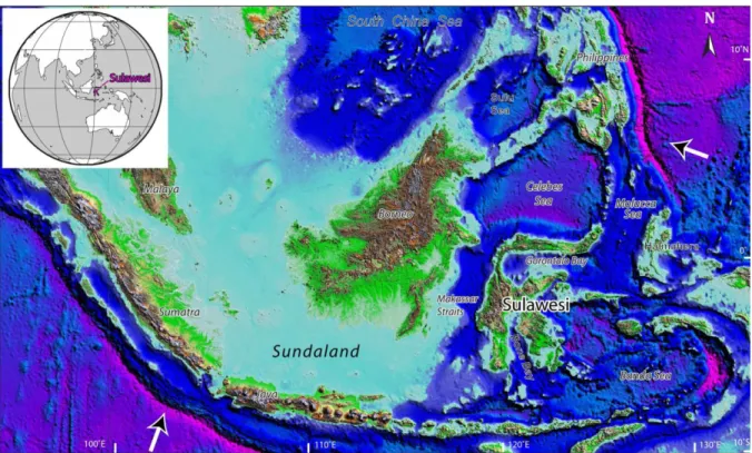
Located between Borneo in the west and the Moluccas in the east, the K-shaped island of Sulawesi (Figure 1) is the largest island in Wallacea (Hall, 2012a), the series of islands stretching between the Eurasian and Australian continental plates. Sulawesi, comprising four long, narrow mountainous arms separated by deep bays, is the spiritual heartland of Wallacea as it was here that Alfred Russell Wallace first recognised the spectacular divide between Asian and Australo-Pacific biogeography and set up the resultant “Wallace Line” to the west of Sulawesi in the Makassar Strait.
Rapid geographic changes have occurred throughout Wallacea over the last 100 million years. The biogeographical complexity reflects
significant changes in vertical and horizontal distribution of land and sea which in turn reflects the complex geological history, largely driven by subduction and strike-slip fault movements.
Sulawesi has a remarkable biodiversity, a gloriously rich endemic fauna, and complex geology that has attracted natural scientists since the 19th century (Nugraha and Hall, 2018). Plate tectonic hypotheses and tectonic reconstructions for many years interpreted the region in terms of multiple collisions but there have been significant changes in our understanding of Sulawesi's geology in recent years, in particular the importance of Neogene extension as have the timing and speed of change
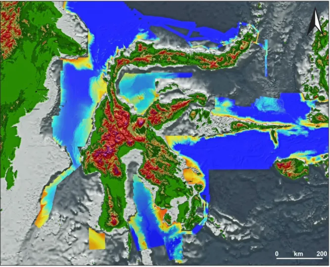
Figure 1: Sulawesi Locality Map; major plate motions relative to Sundaland indicated (modified after Hennig et al., 2017).
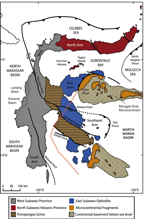
Figure 2: Major geological units and faults of Sulawesi (modified after White et al., 2014). Orange dotted line indicates limit of “Australian” continental crust (after Hall et al., 2017).
which led to the formation of the island's high mountains and deep basins (Nugraha and Hall, 2018).
In this paper, we provide a comprehensive summary of the geology of offshore and onshore Sulawesi utilising, where possible, modern high- resolution bathymetry to demonstrate recent and ongoing tectonics.
REGIONAL GEOLOGY
Sulawesi lies within Eastern Indonesia in a highly complex and dynamic plate tectonic setting located at the meeting of three major tectonic plates – the oceanic/continental Indo-Australian, predominantly continental Eurasian and oceanic Pacific/Philippine Sea plates. As a result of plate interactions, a complex system of subduction, back- arc-thrusting, extension, and major transform zones have generated a composite assemblage of small marginal ocean basins and microcontinental blocks bounded by subduction zones, extensional margins, and major transcurrent faults (Hall, 1996). The region is extremely susceptible to seismic activity, and volcanic arcs line compressional tectonic boundaries.
On the eastern margin of Sundaland, Sulawesi consists of an intricate mosaic of Gondwana-derived fragments, obducted oceanic crust, high pressure metamorphic belts, island arc and continental margin igneous suites, and a variety of sedimentary sequences which were assembled during Late Mesozoic to Late Cenozoic times (Figures 2 & 3). Broadly, Sulawesi consists of two terranes; a western magmatic belt, paired with an eastern
terrane comprising ophiolite, blueschist, and continental fragments (Sula and Buton microcontinents), the latter derived from the Australian continental plate. Tertiary collision between these microcontinents and Western Sulawesi has inactivated west- directed subduction south of the northern tip of Sulawesi, and has led to arc reversal, with renewed subduction from the North Sulawesi Trench (Soeria- Atmadja et al., 1999; White et al., 2017).
From a magmatic perspective, Sulawesi can be sub-divided into four litho- tectonic provinces, namely: (a) the Western and North Sulawesi Plutonic- Volcanic Arc, located in the South Arm and West Sulawesi through the Neck and the North Arm; (b) the Central Sulawesi Metamorphic Belt, (c) the East Sulawesi Ophiolite Belt in the East Arm, and; (d) the Banggai-Sula and Tukang- Besi continental fragments in the Southeast Arm (Figure 2; Soeria- Atmadja et al., 1999; Maulana et al., 2020).
Intrusive rocks, varying in composition from granitic to gabbroic cover almost 20% of the island, with the largest concentrations occurring in western Sulawesi. These rocks and sometimes associated with gold and copper mineralization (e.g., Perello, 1994;
Bergman et al., 1996; Elburg et al., 2003; Maulana et al., 2020).
“Basement” Rocks and Magmatism The question of the age and origin of the
“basement” rocks of Sulawesi remains the single most unresolved question in Sulawesi geology.
Much dating has been carried out recently and many previous assumptions have proved to be erroneous; many supposed Mesozoic or Palaeozoic rocks have been shown to be Neogene in age (Figure 4). Suffice to say, we are not aware of a single modern date which has been older than that previously assumed.
The rocks of Southeast Sulawesi include blueschists, intervening peridotites and other metamorphic rocks (including parts of the Sula Spur microcontinent).
This apparently simple configuration of continent, accretionary complex, ophiolite, and continent has been interpreted to be mainly the result of convergence and accretion.
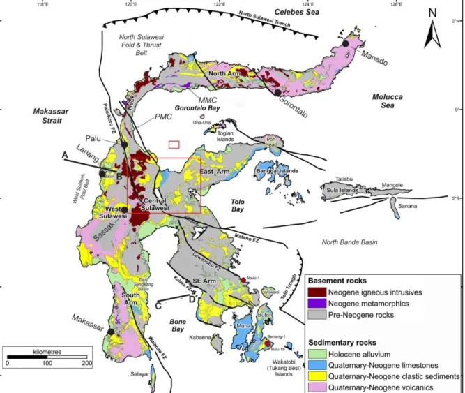
Figure 3: Simplified geological map of Sulawesi with major structures and litho-tectonic units indicated (modified after Nugraha and Hall, 2018). Positions of Palu Metamorphic Complex (PMC) and Malino Metamorphic Complex (MMC) indicated. Line A-B indicates approximate position of the geoseismic section shown on Figure 6 and line C-D the seismic line on Figure 11. Small red rectangle in Gorontalo Bay marks position of Figure 10A; larger red rectangle in central Sulawesi marks position of Figure 10B.
Metamorphic complexes in West and Central Sulawesi were emplaced or formed as consequence of mid- Cretaceous accretion of Australian continental fragments to Sundaland.
During the Early Eocene western Sulawesi rifted away from Borneo forming the Makassar Strait at the same time as oceanic spreading in the Celebes Sea. From the Middle Eocene to Late Oligocene the North Arm Volcanic Arc formed as consequence of north- directed subduction of the Indian Ocean
beneath the North Arm. In the Early Miocene, the East Sulawesi Ophiolite was emplaced by northwest - directed obduction during collision of the Sula Spur with the North Arm. The Central Sulawesi Meta- morphic Belt includes meta- morphic rocks associated with the ophiolite, the Sundaland margin and the Banggai–
Sula Block. Regional extension, from Sulawesi eastwards, commenced in the Middle Miocene, associated with rollback of sub- duction into the Banda embayment.
There was wide- spread magmatic activity in the Western Sulawesi Igneous Province, probably mainly extension-related, from the Middle Miocene producing high-K calc-alkaline acidic igneous rocks.
Subduction of the Celebes Sea under the North Arm is interpreted to have started around 5 Ma, but the subduction is quite complicated with both southward and eastwards subduction and associated volcanism across the entire length of the North Arm. Subduction rollback of the North Sulawesi subduction zone initiated a new phase of extension in northern
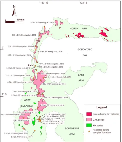
Figure 4: Map showing distribution of late Miocene-Pliocene granitoids with dates (after Liu et al., 2020, incorporating dating reported by Hennig et al., 2016 and White et al., 2017); CAK = felsic high-K calc- alkaline suite, HK = mafic potassic to ultrapotassic suite.
Sulawesi which has been active until the present-day.
In West Sulawesi, there is no geological/geophysical evidence for oceanic subduction in the Late Miocene, with the magmatic flare-up occurring ∼8 m.y. after the collision of the Tukang Besi-Buton microcontinent in the Middle Miocene and ∼2 m.y. before the docking of the Banggai-Sula microcontinent in the Early Pliocene (Hall, 2002; Metcalfe, 2010).
Magmatic zircons in West Sulawesi yielded weighted mean ages of ca. 7.2–
6.1 Ma. the preponderance of Late
Miocene magmatism, showing a noticeable climax of magmatism (flare- up) at ~7–6 Ma that forms a continuous magmatic belt throughout West Sulawesi. The geochemistry indicates significant involvement of continental crustal materials in petrogenesis, in accordance with the common presence of Precambrian to Mesozoic zircons in the Late Miocene igneous rocks. This magmatic flare-up in West Sulawesi and coeval regional extension in eastern Indonesia are attributed to a resumed episode of slab rollback of the Banda slab into the Banda Embayment (Zhang et al., 2020).
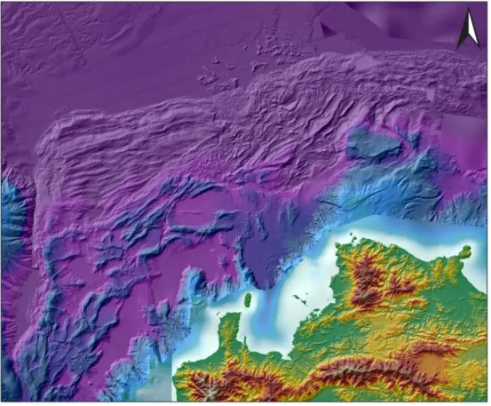
Figure 5: Composite image of Sulawesi topography and bathymetry; compiled from available data.
STRUCTURAL ELEMENTS
Sulawesi comprises numerous disparate geological units brought into (temporary) juxtaposition by tectonic movements. Figure 5 is a composite image of Sulawesi and its offshore areas utilising SRTM topographic and available high resolution bathymetric data. These data give a total topographic visualization of Sulawesi and provide a wonderful insight into neotectonics and offshore sedimentary features. Clearly evident on the figure are the emerging West Sulawesi Fold Belt on the eastern side of the Makassar Strait, strong linear features such as the Palu-Koro fault and other faults though central and southern Sulawesi, the deep extensional basins of Gorontalo Bay, Bone Bay and the North Banda Basin.
Several major structures may affect more than one litho-tectonic unit (Hamilton,1979; Silver et al., 1983;
Parkinson et al., 1998). Included within these are a number of structures interpreted as strike-slip features, mostly with an inferred sinistral motion, while other major structures have usually been interpreted as compressional features; in the last decade large detached extensional faults have been recognised near the coast in central Sulawesi.
West Sulawesi (including South Arm) West Sulawesi consists of a metamorphic basement overlain by Late Cretaceous turbidites that were deposited in a forearc setting (Figure 2).
These are in turn covered by volcanic- sedimentary successions that were deposited during the early Middle
Eocene to earliest Miocene (van Leeuwen and Muhardjo, 2005). It forms the (rifted) continental margin of eastern Sundaland with basement complexes of Gondwanan origin occurring in West Sulawesi and the South Arm. The microcontinental fragments rifted from Australia in the Jurassic and accreted to Sundaland in the Cretaceous and developed in a continental margin setting on the eastern margin of Sundaland during the Late Cretaceous and Paleogene. (e.g., Parkinson et al., 1998; Hall et al., 2009; Hall, 2012a).
In the Lariang/Karama region, 3,500 m of Eocene to Oligocene mixed terrestrial and marginal marine sedimentary rocks are unconformably overlain by early to late Miocene shallow marine carbonate and mudstones in turn overlain by early Pliocene shelf sediments and the Plio- Pleistocene syn-orogenic Pasangkayu Formation (“Celebes Molasse”) (Calvert and Hall, 2007). Oil seeps have been known for over 100 years: the abundance of terrestrial biomarkers and the presence of saturated oleane biomarkers suggest a source deposited in a deltaic or nearshore environment (Sutadiwiria et al., 2018) It is likely that the source rocks are syn-tectonic Eocene coals or carbonaceous mudstones.
Serpentinized ultramafic rocks occur in two separate basement complexes in the South Arm, the Bantimala and Barru Blocks. Both are derived from a supra- subduction zone environment and were obducted during the closure of small back-arc basins. The ultramafic suites from these two blocks are juxtaposed with metamorphic assemblages, which were later intruded by younger volcanics
(Maulana et al., 2015; Jaya et al., 2017).
Detrital zircon age distributions of the basement rocks in the South Arm display predominant Mesozoic (Cretaceous and Triassic) and Palaeozoic populations with a small population of Proterozoic ages supporting the hypothesis that the West Sulawesi block originated from the region of the Bird's Head, namely the Inner Banda block (Jaya et al., 2017).
South Sulawesi has an almost complete stratigraphic succession (Figure 3) spanning the late Cretaceous to the present day, with carbonate and igneous lithologies spanning much of the Tertiary (Wilson, 1999). It is dominated by a west-verging Late Miocene to Pliocene collisional orogen in the north and a later (Late Pliocene) major NNW-SSE trending sinistral strike-slip fault system which has produced a pull-apart basin (Walanae Depression) with elevated rift shoulders along its margins (Western and Eastern Divide ranges) (Guritno et al., 1996;
Wilson and Moss, 1999).
Two disparate terranes in the South Arm are juxtaposed across the sinistral Walanae fault zone which extends into Bone Bay. In the west, Paleogene arkosic sandstone, siltstone, claystone, marl and conglomerate, intercalated with layers or lenses of coal and limestone are overlain by a thick succession of shallow marine carbonate which continued until the middle Miocene, on high blocks, surrounded by deep marine sedimentation (Tonasa Carbonate Platform; Coffield et al., 1993; Wilson and Bosence, 1996;
Wilson and Moss, 1999). The main factors affecting carbonate depositional environments and facies distributions were differential subsidence, controlling water depths and accommodation space, types of carbonate producers and active faulting (Wilson, 1999). East of the fault zone, lithologies are quite distinct from those to the west and the oldest lithologies are of Eocene age (Maulana et al., 2015).
Cenozoic magmatism occurs throughout West Sulawesi, whose petro- genesis, sources, and tectonic settings have been relatively well constrained by
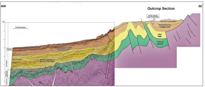
Figure 6: Onshore and offshore geological seismic section West Sulawesi Fold Belt (modified after Isis, 2005); location of section shown on Figure 2 as line A-B.
extensive geological, petrologic, geochemical, and isotopic investigations (Polvé et al., 1997; Elburg et al., 2003;
Maulana et al., 2015, 2016; Jaya et al., 2017). A notable feature of the Late Cenozoic igneous rocks is that they have an almost exclusively potassic to ultra- potassic composition. They can be subdivided into a shoshonitic to ultra- potassic (HK) series and a high-K calc- alkaline (CAK) series and are interpreted to have formed in a post-subduction (extensional) tectonic setting (Elburg et al., 2003).
The most significant Cu–Au mineralization is at Sassak which occurs in a quartz syenite intrusion of shoshonitic affinity; K–Ar dates of nearby related rocks range from 10.6 to 11.9 Ma (Priadi et al., 1994). The Sassak Cu–Au porphyry is located within the Walanae fault zone (Soeria- Atmadja et al., 1999).
West Sulawesi Fold Belt
The West Sulawesi Fold Belt (WSFB;
Figures 3, 6 & 7), first mentioned by Coffield et al. (1993) was described in some detail in the offshore area adjacent to the Lariang-Karama region of western Sulawesi by Fraser et al.
(2003). The Lariang-Karama region covers the central and southern onshore parts of the WSFB and was described by Calvert and Hall (2003).
The WSFB lies immediately west of the Palu-Koro Fault, a major crustal lineament initially set up by spreading within the Celebes Sea during the Eocene, and part of the greater Sorong fault system.
Figure 6 is a composite seismic and geological section through both the
offshore and onshore sectors of the WSFB and shows the basement involved tectonics onshore near the basin margin and the intensity of the deformation decreasing towards distal parts of the fold belt where deformation appears to be ongoing.
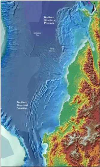
The offshore WSFB (Figure 7) is not a single fold belt and is divided into three structural provinces based on seafloor characteristics, subsurface deformation, and in particular the character and position of the deformation front: the Southern Structural Province (SSP) a west-verging thinned-skinned fold-and-thrust belt
Figure 7: Composite bathymetric and SRTM image of West Sulawesi Fold Belt.
with thrust faults detaching on different decollement layers; Central Structural Province (CSP) with less deformation;
and the Northern Structural Province (NSP) strongly deformed where folding, thrusting, and detachment layers are difficult to interpret (Puspita et al., 2005). It is considered there is similar contraction in all three areas, but compression in the CSP did not ramp up into a Tertiary detachment as it did in SSP and NSP and all the offshore compression was taken up by basement-involved thrusting onshore (Figure 6).
The age of folding is well-constrained onshore where continental alluvial plain and marine deposits of the Plio- Pleistocene Pasangkayu Formation
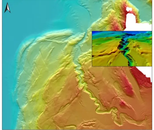
(“Celebes Molasse”) formed in response to uplift of the hinterland. Continuing deformation is recorded on offshore seismic sections and syn-depositional folding of younger parts of the Pasangkayu Formation (Calvert and Hall, 2003; Fraser et al., 2003). A spectacular canyon, no longer active, eroded into the WSFB by the paleo-Palu depositional system (Baillie et al., 2008) is shown as Figure 8.
The Neck and North Arm
The section describes the land portion of Sulawesi north of the western part of the Palu-Koro Fault system and comprises the Sulawesi Neck and the North Arm (Figures 2 & 3).
Figure 8: Bathymetric image of northern sector of West Sulawesi Fold Belt showing prominent Palu Canyon shown as oblique view inset (after Baillie et al., 2008).
The North Arm is varied and complex with volcano-plutonic, sedimentary and metamorphic suites present in an intra- oceanic arc of tholeiitic to calc-alkaline composition built on Eocene oceanic crust Two distinct geochemical provinces are present (Elburg et al., 2003; van Leeuwen and Muhardjo, 2005). Porphyry Cu-Au and Mo mineralisation is associated with magmatic processes in the North Arm: a lower crustal source for Mo and Au-rich porphyry systems independent of the nature of the crust and derived from mantle sources has been suggested (Soeria-Atmadja et al., 1999).
Geochemical and isotopic data indicate that the North Arm was part of an arc system between 51 and 18 Ma, with eruption and intrusion of subduction- related magmas of continental affinity in the western part of the area and of oceanic affinity in the east (Elburg et al., 2003). High-K magmatism in the west started around 14 Ma, and its isotopic signature can only be explained by a source with a long and varied geochemical history, probably located within the Australian subcontinental lithospheric mantle.
Volcanic activity in the region is a consequence of dual subduction of the Molucca Sea, west beneath North Sulawesi and east beneath Halmahera.
Paleocene to Pliocene magmatism shows a progression from an Older Series with calc-alkaline /tholeiitic signatures (51–
17 Ma) to a Younger Series of mafic- intermediate high-K magmas (14–5 Ma) and felsic K-rich calc-alkaline magmas (9–2 Ma). The isotopic and geochemical compositions of the Older Series samples indicate that the more westerly
samples have been generated in a continental arc setting and the more easterly samples in an oceanic arc (Elburg et al., 2003).
The North Sulawesi subduction zone has been active since about 8 Ma (Hall, 2011), located to the north of an earlier Tertiary volcanic arc (Hall, 2012b). Age dating of calc-alkaline rocks associated with subduction from the north took place 2.35 Ma (Pliocene) age (Perello, 1994). Ten active volcanoes overlie the subduction zone which underlies North Sulawesi and the Sangihe Islands. The Tondano caldera, immediately south of Manado (Figure 2), is a 15x30 km NE- SW elongate caldera formed by large volume explosive eruptions and caldera collapse. It contains small inactive post- caldera volcanoes and an active geothermal system and is ringed by weakly welded and intensely dissected ignimbrite deposits (Kushendratno et al., 2012).
Low-temperature thermochronology on apatite from granitoid rocks in the Neck reveals rapid exhumation rates of 0.75–
0.9 mm/yr that indicate removal of around 2 km of upper crust since the Middle Pliocene (Hennig et al., 2014).
Two significant metamorphic complexes are present in the Neck and North Arm and provide information on the high speed at which tectonic processes, including magmatism, exhumation, and reworking into a sediment, must have occurred (Hennig et al., 2017).
The Palu Metamorphic Complex (Figure 3; van Leeuwen et al., 2016) represents a medium-P metamorphic belt, ranging from chlorite to staurolite grade metamorphism, which is exposed immediately adjacent to the Palu Fault.
Its lithologies are dominated by biotite gneiss and schist, with subordinate amphibolite, granulite, migmatite, peridotite, calc-silicate rocks and meta- granitoids. The metamorphic rocks are strongly deformed, and some were partially melted to form migmatites.
Metamorphic rocks of the PMC have yielded Early to Late Pliocene cooling ages. Intruded S-type granites have similar Pliocene ages. Both show very fast cooling rates, indicating rapid exhumation of the complex (Hennig et al., 2017).
The Malino Metamorphic Complex (Figure 3; MMC) is in the western part of the North Arm and consists predominantly of quartzo-feldspathic schist and gneiss, with intercalations of
quartzite, graphite schist, marl and amphibolite. Greenschists form a discontinuous selvage around the complex. The MMC is interpreted as a metamorphic core complex which underwent lithospheric extension during the Early–Middle Miocene.
Exhumation took place during a second phase of extensional uplift was accommodated by brittle faulting from the Late Miocene-Pliocene onwards.
Preliminary zircon dating and isotope analysis indicate that their igneous and sedimentary protoliths were old continental crust, probably of Australian derivation. Reconnaissance dating indicates that the MMC rocks were metamorphosed in the mid- Miocene (23–11 Ma) (Advokaat et al., 2017).
Figure 9: Bathymetric image of north-western sector of North Sulawesi Fold & Thrust Belt;
prominent N-S lineament on western edge of mage is the Palu Fault.
North Sulawesi Fold & Thrust Belt The North Sulawesi Fold & Thrust Belt (NSFTB) occurs offshore of the North Arm in the southern part of the Celebes Sea (Figure 3). It is bound to the north by the North Sulawesi Trench.
Deformation is related to Palu-Koro fault zone movements and subduction of the Celebes Sea beneath the North Arm.
Seismic evidence in the northern Makassar Strait shows the presence of major flower structures between the present day Mangkalihat Peninsula and Sulawesi representing periods of transpression developed along the Palu- Koro fault system “structural freeways”
(Fraser et al., 2003).
Seafloor bathymetry (Figure 9) shows the characteristic fold-and-thrust belt geometries as well as several ovoid basins immediately north of the North Arm which appear to be extensional (or perhaps transtensional), related to the rollback of the southward subducting Celebes Sea since the Pliocene (Advokaat et al., 2017, Tiranda and Hall, in prep). The continuation of the Palu- Koro fault system forms a prominent lineament against the Mangkalihat Peninsula, there is no evidence of faults crossing from Sulawesi into Borneo.
Deformation in the NSFTB is interpreted to have occurred from the latest Miocene or Pliocene to present with subduction of Celebes Sea at the North Sulawesi Trench and movement on the Palu-Koro Fault (Tiranda and Hall, in prep).
Gorontalo Bay
Gorontalo Bay (Figure 2; also known as the Gulf of Tomini) is a deep, inter-arm
sea, bounded by the mountainous North Arm on the north, central Sulawesi and the East Arm on the south and bounded by to the west by the narrow Sulawesi Neck. It is surrounded by mountains up to 2–3 km high formed by metamorphic complexes and granitoid intrusions that can be traced from the Central North Arm to the Neck and further south into mid Central Sulawesi (Hennig et al., 2014). A thick depositional succession within the bay exceeds ten kilometres in thickness (Jablonski et al., 2007).
Pholbud et al. (2012) recognised a three- part stratigraphy: basement is proposed to be Sundaland continental crust, below a major unconformity interpreted to be either Mid Eocene or Early Miocene in age; above the unconformity is a sequence up to 6 sec TWT divided into a lower part interpreted as quartz-rich marine sediments, with little volcanic debris, derived from granites and continental basement of western Sulawesi and an upper shallow-water carbonate succession. At the top of the succession and imaged beautifully on bathymetric data (Figure 10A, for location see Figure 3) are submerged reefs and pinnacle reefs which mark rapid subsidence which began at about 5 Ma and are partly buried by Pliocene–
Recent deep-water deposits in the basin centre. Initiation of subsidence has been related to rollback-driven extension from the North Sulawesi Trench (Cottam et al., 2011; Hall, 2011, 2012a; Hennig et al., 2014).
Rapid subsidence began at about 5 Ma and rates of subsidence eventually exceeded rates of carbonate production, killing all the reefs except for rare pinnacles and close to the present
coastlines, and exceeding rates of clastic supply, so that they are now between 1800m and 2000m deep in their deepest parts.
Una-Una (Figures 2 & 3) is an isolated active calc-alkaline shoshonitic volcano (Sendjaja et al., 2018). Broom-Fendley et al. (2011) have proposed that Una- Una and the nearby Tongian Islands (~2 Ma) are the product of young extension of Gorontalo Bay due to slab roll-back.
East Arm
Central Sulawesi comprises metamorphic rocks of the former accretionary margin of Sundaland (Parkinson, 1998), which are over- thrusted by a complete, but dismembered, ophio- lite exposed in the East Arm (Parkinson, 1998;
Kadarusman et al., 2004). The ophiolite belt extends from central Sulawesi to the east and southeast arms, in- cluding Buton and Muna Islands.
The East Sulawesi Ophiolite (ESO), one of the three largest ophiolites in the world, is a tectonically dis- membered full suite of ophiolite lithologies and comprises, from base to top, residual mantle peridotite and mafic–
ultramafic cumulate through layered to iso- tropic gabbro, to sheeted dolerites and basaltic volcanic rocks of normal mid-oceanic-ridge basalt (MORB) composition (Parkinson, 1998;
Kadarusman et al., 2004). Trace element data on the lavas and dolerites, and particularly their depletion in Nb compared to neighbouring incompatible elements, suggest a subduction zone environment for their origin (Monnier et al., 1995).
It is intercalated with Cretaceous or Mesozoic pelagic sedimentary rocks
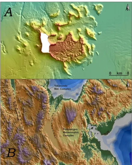
Figure 10: Evidence of extension in and around Gorontalo Bay. (A) Bathymetric image of prominent submerged carbonate complex, Gorontalo Bay. Base of the complex around 1300m water depth, central part of the complex 600–800m, pinnacle tops 400–500m. (B) SRTM image of northern Central Sulawesi showing metamorphic complexes.
A
B
Metamorphic ages (28–32Ma;
Parkinson, 1998) from rocks overthrust by the East Sulawesi Ophiolite suggest emplacement of this ophiolite sequence occurred during or after the middle to late Oligocene. The geochemical variations and disparities for both peridotite and basalt and the non- cogenetic relationship between crust and mantle sections in several locations suggest that the ESO may have been formed at one tectonic setting and was later overprinted by magmatism in different environments through its birth to emplacement. A possible Cretaceous origin of an oceanic plateau has been suggested (Kadarusman et al., 2004).
The Central Sulawesi metamorphic belt is confined to the central part of the eastern arm of the island and is considered to have resulted from collision between fragments of Gondwana origin and the active Asian margin in the Late Oligocene or Early Miocene. It consists of sheared metamorphic rocks including the Pompangeo schist complex and a melange complex (Parkinson, 1998), as well as an ophiolite terrane (Lamasi Complex) (Polve et al., 1997). This region has been interpreted to represent an accretionary complex that was formed during Cretaceous and Paleogene times, as a suture between the western and eastern parts of Sulawesi (Hamilton, 1979; Parkinson et al., 1998).
Obduction did not involve westward thrusting of a piece of Australia on the Eurasian margin but was more likely emplaced by north-to-south obduction of the margin of the Eurasian plate, represented by the Celebes Sea, over the basement of eastern Sulawesi, probably
of Australian origin (Monnier et al., 1995)
Southeast Arm
The Banggai-Sula islands lie offshore to the east of the East Arm, whilst Tukang- Besi, Buton and the surrounding islands are located to the southeast of the tip of the Southeast Arm (Figure 3).
On the Banggai-Sula islands Permo- Triassic slate, schist, and gneiss are intruded by Permo-Triassic granitoids.
These metamorphic and igneous rocks, which comprise the basement complex, are microcontinental fragments of Australian origin were previously considered to be separate fragments sliced from New Guinea and carried west along the Sorong Fault system (Hamilton, 1979; Garrard et al., 1988).
They are now interpreted as part of the Sula Spur that collided with the North Arm in the Early Miocene and subsequently fragmented (Spakman &
Hall, 2010; Hall, 2011).
The Mesozoic and Tertiary successions of Buton and Tukang-Besi are similar to those on Banggai-Sula and considered to have Australian affinities (Pigram &
Panggabean, 1984; Garrard et al., 1988).
To the east of the Southeast Arm, large gravitational collapse structures in the the Tolo Trough are interpreted to be caused by the regional exhumation of Sulawesi (Rudyawan and Hall, 2012;
Titu-Eki and Hall, 2020). Abundant normal faults in the area are due to extension related to subduction rollback in the Banda Sea (Spakman and Hall, 2010; Titu-Eki and Hall, 2020)
Bone Bay
Bone Bay (or Gulf) is located between the South and SE Arms of Sulawesi and is the site of a thick undeformed synrift Neogene section with carbonate buildups on both basin flanks and deeper marine sediments in axial parts.
The main basin trends N-S and is divided into several sub-basins and highs. Based on modern 2D seismic and multibeam bathy-metry we suggest that
the basin is largely transtensional in origin: some seismic sections show classic half-graben geometry (Figure 11) others show a “bath-tub” section with steep sides to both the west and east.
A prominent channel system is present in the centre of the basin with the main channel having a width of up to 3 km (Figure 11). The channelling is only present above a marked probable Early Pliocene unconformity. This event records major uplift of Sulawesi and subsi- dence of Bone Gulf with resultant major influx of clastic sedi-ments from the north, development of a southward - flowing canyon system, and back-stepping and drowning of carbonates at the basin margins (Camplin and Hall, 2014).
It is suggested that the prominent channel is formed by density flows initiated by large volumes of water fed into the gulf by annual rains (Baillie et al., 2008). The climate of Sulawesi is tropical with two seasons: “dry” from March to September, and “rainy” from October to February.
The city of Makassar, located to the west of Bone Bay on the South Arm average rainfall
around 1,000–
1,500mm per year;
Figure 11: Bone Bay bathymetric and seismic images. (A) bathymetry image of Bone Bay. (B) seismic image of basin infill, location of line shown as line C-D on Figure 2 (C) detailed bathymetric image of main channel. (D) Seismic image showing channel
development of main channel.
orographic rain is significantly higher in higher areas.
SYNTHESIS AND TECTONIC EVOLUTION
While the broad details of its geology have long been known, the tectonic evolution of Sulawesi is very complex, remains controversial, and not fully understood.
Until the last decade, there had been consensus that Sulawesi was largely the product of contractional and strike-slip tectonics and consequent rotation. For example, Katili (1978) regarded Sulawesi as the result of early Pliocene collision of Sulawesi and the Australian- New Guinea plate, transforming Sulawesi into an island with its convex side turned towards the continent, at the same time causing obduction of ophiolite in the eastern east of the island. Similarly, Silver et al., (1983) postulated that Sulawesi had been shaped and deformed because of collision with the Sula platform and that the collision had resulted in rotation of the North Arm and the development of the North Sulawesi Trench.
In a landmark paper, Pigram and Panggabean (1984) recognised detached continental fragments of Australian origin in Eastern Indonesia, including parts of Sulawesi, and proposed a model of tectonic transport by seafloor spreading – colloquially known as the
“salami slicer” model. It became generally accepted that collisions in Sulawesi had been driven by terrane from the east.
That model began to be questioned in the past 15 years or so as the result of the huge amount of new information becoming available from GPS measurements, SRTM, satellite and bathymetric imagery, advanced radiometric dating, seismic imaging carried out by the petroleum exploration industry, seismic tomography, and importantly, the field-based work of Professor Robert Hall and his students at Royal Holloway, University of London.
Figure 12 is a series of tectonic reconstructions (after Hall, 2012b) is used to illustrate the tectonic development of the Indian Ocean–
Indonesia region at selected time intervals since 120 Ma (that is, Early Cretaceous).
There are two main periods of activity, (a) a Mesozoic and Paleogene period of formation of the main tectonic “blocks”
which would eventually comprise Sulawesi, and (b) Neogene moving and interaction of the blocks to build Sulawesi.
Rotation
Internal rotation of fragments within Sulawesi is thought to have been achieved via a linked system of strike- slip and thrust faults (Hamilton, 1979;
Silver et al., 1983). This rotation is related to the accretion of microcontinental fragments onto eastern Sulawesi and to the subduction of oceanic crust of the Celebes Sea southwards down the North Sulawesi Trench (Hamilton, 1979; Silver et al., 1983; Parkinson, 1998). To accommo-
Figure 12: Montage of tectonic reconstructions of Indian Ocean - Indonesian region at selected times (after Hall, 2012b). (A) 120 Ma: East Java–West Sulawesi (EJWS) and Southwest Borneo (SWB) have moved away from Australia and closing on Sundaland margin. (B) 65 Ma: EJWS and SWB part of Sundaland; brief episode of NW-directed subduction marked by volcanic activity in West Sulawesi.
(C) 45 Ma: Celebes Sea spreading in a back-arc setting; Ceno-Tethys subducted northwards from Sumatra to Halmahera. (D) 25 Ma: Sula Spur about to contact the North Arm volcanic arc. (E) 10 Ma:
Subduction rollback of the Celebes Sea caused spreading of the Sulu Sea in a back-arc setting;
rollback into Banda Embayment caused extension of the Sula Spur to form the North Banda Sea. (F) 5 Ma: Molucca Sea subduction was almost complete, Halmahera and Sangihe arcs about to collide;
Sulawesi amalgamation almost complete.
date this movement, linkage of a splaying fault system across Sulawesi has been suggested (Hamilton, 1979;
Silver et al., 1983; Parkinson, 1998).
Socquet et al. (2006) showed that ongoing deformation of Sulawesi is largely confined to the region north of the Paul-Koro and Lawanopo fault systems (Figure 2) and can be reasonably described by a small number of rapidly rotating crustal blocks (Figure 13). Relative to the Sunda Plate, the southwestern part of Sulawesi rotates anticlockwise at 1.4°/Myr. The north- eastern part of Sulawesi comprises three blocks rotates clockwise at 2.5–
3°/Myr. South of the Palu-Koro fault system, GPS observations showed that the relative motion between Sundaland and Sulawesi is small (<2 mm yr−1), but north of the fault system accommodation rates varied from 11 to 42 mm/year (Socquet et al., 2006). The authors noted that Sulawesi provides a primary example of how collision can be accommodated by crustal block rotation instead of mountain building.
Wrench Faulting
The sinistral wrench systems are the western extremity of one of the most important and longest structural elements in the Western Pacific and Southeast Asia. The eastern end is the Sorong fault system (SFS), the southern boundary of both the Molucca Sea and the Philippine Sea plates with the Australian Plate (Hall and Wilson, 2000). The SFS, initiated no later than the early Miocene and still active, the result of oblique convergence of Australia and the Philippine Sea plates, has been responsible for translating continental fragments from the
northern margin of the Australian Plate (i.e., the Bird’s Head of New Guinea) into the outer edge of Sundaland (Pigram and Panggabean, 1984; Hutchison, 1996). There is no evidence that the Sorong fault system extends into Sulawesi beyond the Sula islands;
instead, there is a highly extended continental margin north of the North Banda Basin which is underlain by Middle Miocene–Pliocene (12.5–7.3 Ma) oceanic crust (Rudyawan and Hall, 2012).
During the Pliocene, prior extensional settings in the Makassar Strait became compressional as the Sulu Spur collided with the south-eastern corner of Sundaland. This collision not only helped assemble Sulawesi into its current (ephemeral) K-shape but also formed the WSFB, progressively obscuring the original Eocene rift system in the Makassar Strait (Fraser et al., 2003).
The WSFB is the direct result of transpression and collision, resulting from movements on the Paul-Koro fault system. Walsperdorf and Vigney (1998) reported five years of GPS measurements across the Palu-Koro fault showing left lateral strike-slip of 3.4 cm/yr with a small normal component of 0.4 cm/yr.
Wrench faulting is important in the Bone Bay area and has produced multiple depocentres and structural highs (Camplin and Hall, 2014). We believe a sinistral strike-slip fault system extends in a general north- northwesterly direction from Bone Bay through the South Arm and is responsible for the formation of the
thick, transtensional depocentre in Bone Bay.
Fission Tack and Fault Kinematics Fault kinematic and fission-track analyses show that the Late Cenozoic central Sulawesi deformation results from three successive tectonic regimes:
1. A Late Miocene–early Pliocene WNW-trending shortening characterized by transpressional deformation along the Palu-Koro Fault. This resulted from the collision between the Sula Spur with Sulawesi and produced locally a transpressional regime because of the northward extrusion of the Central Sulawesi block limited by the Palu-Koro Fault. Soon after 25 Ma the Sula Spur began to collide with the North Sulawesi volcanic arc, and this is the first Australia–SE Asia collision. Ophiolites were thrust onto the continental crust, derived from the ocean north of the Sula Spur and probably from the North Sulawesi fore-arc (Hall, 2011).
2. A Pliocene collapse tectonic regime associated with W-trending extension. Coeval with these events regional cooling and exhumation took place.
3. A Quaternary transtensional regime resulting from the combined effects of the Central Sulawesi block northward motion, and extension related to back- arc spreading behind the North Sulawesi sub- duction zone (Bellier et al., 2006).
Figure 13: Sulawesi rotation. (A) GPS velocities and interpreted blocks, East Indonesia (after Socquet et al., 2006; Hall, 2011) (B) rotational part of the inferred velocity field relative to the Sunda Plate, error ellipses indicated (after Socquet et al., 2006).
Neogene Extension
Through the latter part of the 20th century and the early part of the 21st, Sulawesi has generally been interpreted as the product of convergence in the Cretaceous and Cenozoic; more recent studies have indicated that extension has played a significant role in its Neogene evolution. For example, high mountains in west Central Sulawesi have been considered the product of magmatism and metamorphism related to Neogene collision; however, new dating of metamorphic and granitoid rocks has identified protoliths and sources of melts and indicates an important role for extension (Hennig et al., 2016).
Late Miocene magmatic flare-up in West Sulawesi and coeval regional extension in eastern Indonesia are attributed to a resumed episode of Banda slab rollback (Zhang et al., 2020). Neogene extensional tectonics has also been recognised in southwest Sulawesi where widespread block-faulting and the onset of potassic volcanism commenced around 14–13 Ma. It reached its peak about one million years later with the juxtaposition of the Bone Group against the Salokalupang Group along the Walanae Fault Zone. Potassic volcanism continued up to the end of the Pliocene, and locally into the Quaternary (van Leeuwen et al., 2010).
Widespread Neogene extension, driven by subduction, has also been recognised as important in the northern part of Sulawesi from central Sulawesi, though Gorontalo Bay and beyond the North Arm where extension exhumed the deep crust in onshore metamorphic core
complexes at the same time as subsidence in Gorontalo Bay.
Analysis of SRTM data for central Sulawesi reveals two grooved, dome-like massifs that form the northern end of the Tokorondo Mountains in the northwest and the Pompangeo Mountains in the southeast (Figure 10B). Each massif extends from near sea level to ~2.5 km elevation. The larger, southeastern corrugated landform, centred on the Pompangeo Mountains and extending over ~2000 km2, consists primarily of marble, phyllite, quartz-mica schist, and meta- conglomerate (Parkinson, 1998). The landforms are interpreted as the denuded footwalls of extensional detachment faults with aerially extensive, topographically smooth footwalls similar to those at other active core complexes (Spencer, 2010, 2011).
The North Arm is deforming in response to gravitational potential energy contrasts. Subduction of the Celebes Sea beneath the northern arm of the island initiated at 8 Ma (Hall, 2011) with the rollback of the slab causing back-arc extension and rapid subsidence of Gorontalo Bay. Rapid uplift and exhumation metamorphics and synchronous rapid subsidence offshore in Gorontalo Bay (Pholbud et al., 2012;
Pezzati et al., 2014) has been interpreted to be linked to northward rollback of the southward-subducting Celebes Sea under the North Arm during the Pliocene to present-day (Hall, 2011).
GPS data show rapid northward motion of the North Arm with respect to the Celebes Sea, indicating that this process is ongoing at present day (Advokaat et al., 2017).
Greenfield et al. (2021) analysed earthquakes around Sulawesi to study the active deformation and suggested that the accretionary wedge above the subducting Celebes Sea is being deformed in response to gravitational potential energy contrasts, spreading from a region of high gravitational potential energy to a lower one. The hot and weak continental fragment is spreading out under its own weight with deformation is driven by stresses transmitted though the lithosphere, rather than tractions on the base of the lithosphere caused by circulation in the underlying mantle.
The importance of the role of extension has become more apparent in recent years and it may be that many more features previously thought to be contraction will be reassessed as due to extension or hyper extension. For example, the Seram–Kumawa shear zone is a newly recognised major Neogene structure within the Australian continental margin of the Banda embayment (Hall et al., 2017). Figure 14 shows a cartoon summary of the major structures during the Early Pliocene development of this structure, and it may be that the continental fragments were dispersed by extension rather than multiple collisions.
Figure 14: Early Pliocene reconstruction of the northern and eastern Banda arc in the Early Pliocene (after Hall et al., 2017): areas shown in light pink were highly stretched by the Early Pliocene and further extended since
CONCLUSIONS
Sulawesi comprises a series of disparate tectonic terranes, developed under a variety continental and oceanic settings, brought into juxtaposition while sedimentation continued and undergoing continuing deformation. The processes involved in that juxtaposition include strike-slip and extensional processes and occurred at very fast rates.
Early Miocene collisions in eastern Sulawesi did not cause orogeny in western Sulawesi. It was only during the Pliocene that the character of sedimentation across the whole of western, central and eastern Sulawesi changed significantly (Hall et al., 2017).
The final juxtaposition of tectonic elements occurred between the Pliocene and the present day. Internal rotation and juxtaposition was achieved via a system of linked faults, the linkage and displacements along faults is still contentious (Wilson and Moss, 1999).
Neogene evolution of the northern Sulawesi involved initial westward subduction and associated magmatic activity followed by collision of the arc with the Sula microcontinent, which resulted in clockwise rotation of the north arm, back-arc thrusting, and inception of southward subduction along the North Sulawesi trench. Rapid uplift on land with contemporaneous subsidence offshore is interpreted to have resulted from extension driven by clockwise rotation of the North Arm associated with northward rollback of the North Sulawesi subduction zone.
ACKNOWLEDGEMENTS
The authors thank Alfend Rudyawan for his thoughtful review of this paper. We also thank the Government of Indonesia for its support for the various projects we were involved with over a number of years. We also acknowledge the numerous colleagues with whom we worked and collaborated, in particular, Robert Hall (Royal Holloway, University of London), Phil Teas, Dan Orange and Ian Longley.
REFERENCES
Advokaat, E.L., Hall, R., White, L.T., Watkinson, I.M., Rudyawan, A. and BouDagher-Fadel, K., 2017. Miocene to recent extension in NW Sulawesi, Indonesia. Journal of Asian Earth Sciences, 147, 378–401.
Baillie, P., Teas, P.A., Decker, J. Orange, D. and Widjanarko, 2008. Contrasting deep-water sediment feeder systems, Sulawesi, Indonesia. Presentation to 2008 Hedberg Conference “Sediment Transfer from Shelf to Deepwater – Revisiting the Delivery Mechanisms”, Ushuaia, Patagonia, Argentina, March 3-7, 2008 (unpublished).
Bellier, O., Sebrier, M., Seward, D., Beaudouin, T., Villeneuve, M. and Putranto, E., 2006. Fission track and fault kinematics analyses for new insight into the Late Cenozoic tectonic regime changes in West-Central Sulawesi (Indonesia). Tectonophysics, 413, 201–220.
Bergman, S.C., Coffield, D.Q., Talbot, J.P. and Garrard, R.A., 1996. Tertiary tectonic and magmatic evolution of western Sulawesi and the Makassar
Strait, Indonesia: evidence for a Miocene continent–continent collision. In: R. Hall and D. Blundell (Eds), Tectonic Evolution of Southeast Asia. Geological Society Special Publication, 106, 301–
429.
Broom-Fendley, S., Thirlwall, M.F., Cottam, M.A. and Hall, R., 2011.
Geochemistry and tectonic setting of Una-Una volcano, Sulawesi, Indonesia.
Goldschmidt Conference Abstracts. In:
Mineralogical Magazine, 2011, 585.
Calvert, S.J. and Hall, R., 2003. The Cenozoic geology of the Lariang and Karama regions, western Sulawesi: new insight into the evolution of the Makassar Strait region. Proceedings Indonesian Petroleum Association 29th Annual Convention, Jakarta, October 14-16, 2003, 501–518.
Calvert, S.J. and Hall, R., 2007.
Cenozoic evolution of the Lariang and Karama regions, North Makassar Basin, western Sulawesi, Indonesia. Petroleum Geoscience, 13, 353–368.
Camplin, D.J. and Hall, R., 2014.
Neogene history of Bone Gulf, Sulawesi, Indonesia. Marine and Petroleum Geology, 57, 88–108.
Coffield, D.Q., Bergman S.C., Garrard, R.A., Guritno, N., Robinson, N.M. and Talbot, J., 1993. Tectonic and stratigraphic evolution of the Kalosi PSC area and associated development of a Tertiary petroleum system, South Sulawesi, Indonesia. Proceedings of the 22nd Annual Convention, Jakarta, Indonesia, 679– 706.
Cottam, M.A., Hall, R., Forster, M., Boudagher-Fadel, M., 2011. Basement
character and basin formation in Gorontalo Bay, Sulawesi, Indonesia:
New observations from the Togian Islands. In: R. Hall, M.A. Cottam, M.E.
Wilson (Eds.), The SE Asian Gateway:
History and Tectonics of the Australia- Asia collision. Geological Society of London Special Publication 355, 177–
202.
Elburg, M., van Leeuwen, T., Foden, J.
and Muhardjo, 2003. Spatial and temporal isotopic domains of contrasting igneous suites in Western and Northern Sulawesi, Indonesia.
Chemical Geology, 199, 243–276.
Fraser, T.H., Jackson, B.A., Barber, P.M., Baillie, P. and Myers, K., 2003.
The West Sulawesi Fold Belt and other new plays within the North Makassar Straits – a prospectivity review.
Proceedings Indonesian Petroleum Association 29th Annual Convention, Jakarta, October 14-16, 2003, 431–450.
Garrard, R.A., Supandjono, J.B. and Surono,1988. The geology of the Banggai-Sula microcontinent, eastern Indonesia. Proceedings Indonesian Petroleum Association, 17th Annual Convention, 23–52.
Greenfield, T., Copley, A.C., Caplan, C., Supendi, P., Widiyantoro, S. and Rawlinson, N., 2021. Crustal Deformation and Fault Strength of the Sulawesi Subduction Zone. Tectonics, 40,
https://doi.org/10.1029/2020TC0065 73
Guritno, N., Coffield, D.Q. and Cook, R.A., 1996. Structural development of the Central South Sulawesi.
Proceedings of the Indonesian
Petroleum Association. 25th Annual Convention, October, 253–266.
Hall, R., 1996. Reconstructing Cenozoic SE Asia. In: R. Hall and D. Blundell (Eds.) 1996. Tectonic Evolution of Southeast Asia, Geological Society of London Special Publication No. 106, 153–184
Hall, R., 2002. Cenozoic geological and plate tectonic evolution of SE Asia and the SW Pacific: computer-based reconstructions, model and animations.
Journal of Asian Earth Sciences, 20, 353–431.
Hall, R., 2011. Australia-SE Asia collision: plate tectonics and crustal flow. In: R. Hall, M.A. Cottam, M.E.J.
Wilson (Eds.), The SE Asian Gateway:
History and Tectonics of the Australia- Asia collision. Geological Society of London Special Publication 355, 75- 109.
Hall, R., 2012a. Sundaland and Wallacea: geology, plate tectonics and palaeogeography. In: D.J. Gower, K.G.
Johnson, J.E. Richardson, B.R. Rosen, L. Ruber and S.T. Williams (Eds.), Biotic evolution and environmental change in Southeast Asia, 32–78.
Hall, R., 2012b. Late Jurassic–Cenozoic reconstructions of the Indonesian region and the Indian Ocean. Tectonophysics, 570-571, 1–41.
Hall, R., Clements, B. and Smyth, H., 2009. Sundaland: basement character, structure and plate tectonic development. Proceedings Indonesian Petroleum Association Thirty-third Annual Convention, Jakarta, May 2009, Paper IPA09-G-134.
Hall, R., Patria, A., Adhitama, R., Pownall, J.M. and White, L.T., 2017.
Seram, the Seram Trough, the Aru trough, the Tanimbar trough and the Weber Deep: a new look at major structures in the Banda Arc.
Proceedings Indonesian Petroleum Association Forty-first Annual Convention, Jakarta, May 2017, Paper IPA17-91-G.
Hall, R. and Wilson, M.E.J., 2000.
Neogene sutures in eastern Indonesia.
Journal of Asian Earth Sciences, 18, 781–808.
Hamilton, W., 1979. Tectonics of the Indonesian Region: US Geological Survey Professional Paper 1078, United States Government Printing Office, Washington, D.C.
Hennig, J., Advokaat, E., Rudyawan, A.
and Hall, R., 2014. Large sediment accumulations and major subsidence offshore; rapid uplift of land:
consequences of extension of Gorontolo Bay and Northern Sulawesi.
Proceedings Indonesian Petroleum Association Thirty-Eighth Annual Convention, Jakarta, May 2014, Paper IPA14-G-304.
Hennig, J., Hall, R. and Armstrong, R.A., 2016. U-Pb zircon geochronology of rocks from west Central Sulawesi, Indonesia: Extension-related metamorphism and magmatism during the early stages of mountain building.
Gondwana Research, 32, 41–63.
Hennig, J., Hall, R. Forster, M.A., Kohn, B.P. and Lister, G.S., 2017. Rapid cooling and exhumation as a consequence of extension and crustal thinning: Inferences from the Late
Miocene to Pliocene Palu Metamorphic Complex, Sulawesi, Indonesia.
Tectonophysics, 712-713, 600–622.
Hutchison, C. S., 1996. South-Eastern Oil, Gas, Coal and Mineral Deposits.
Oxford Monographs on Geology and Geophysics Volume 36. xv + 265 pp.
New York, Oxford: Oxford University Press.
Isis Petroleum Consultants (Perth, Australia), 2005. West Sulawesi geoseismic sections. Report 2005/33 (unpublished).
Jablonski, D., Priyono, P., Westlake, S.
and Larsen, O.A., 2007. Geology and exploration potential of the Gorontalo Basin, Central Indonesia – eastern extension of the North Makassar Basin?
Proceedings Indonesian Petroleum Association 31st Annual Convention, Jakarta, May 2007, Paper IPA07-G-083.
Jaya, A., Nishikawa, O. and Hayasaka, Y., 2017. LA-ICP-MS zircon U–Pb and muscovite K–Ar ages of basement rocks from the south arm of Sulawesi, Indonesia. Lithos, 292-293, 96–110.
Kadarusman, A., Miyashita, S., Maruyama, S., Parkinson, C. C. and Ishikawa, A., 2004. Petrology, geochemistry and paleogeographic reconstruction of the East Sulawesi Ophiolite, Indonesia. Tectonophysics, 392, 55–83.
Katili, J.A., 1978. Past and present geotectonic position of Sulawesi, Indonesia. Tectonophysics, 45, 289–
322.
Kushendratno, Pallister, J.S., Kristianto, Bina, F.R., McCausland, W.,
Carn, S., Haerani, N., Griswold, J. and Keeler, R., 2012. Recent explosive eruptions and volcano hazards at Soputan volcano—a basalt stratovolcano in north Sulawesi, Indonesia. Bulletin Volcanology, 74, 1581– 609.
Liu, J., Zhang, J., Hsia, J., Xian, W.W., Yin, C., Djoko, F.X., Cheng, C., Zhoa, C., Liu, X., Chen, Y. and Yang, X., 2020.
Late Miocene to Pliocene crustal extension and lithospheric delamination revealed from the ~5 Ma Palopo granodioritic intrusion in Western Sulawesi, Indonesia. Journal of Asian Earth Sciences, 20, 1–16.
Maulana, A., Christy, A.G., and Ellis, D.J., 2015. Petrology, geochemistry and tectonic significance of serpentinized ultramafic rocks from the South Arm of Sulawesi, Indonesia. Chemie der Erde, 75, 73–87.
Maulana, A., Imai, A., van Leeuwen, T., Koichiro, W., Yonezu, K., Takanori, N., Boyce, A., Page, L. and Schersten, A., 2016. Origin and geodynamic setting of Late Cenozoic granitoids in Sulawesi, Indonesia. Journal of Asian Earth Sciences, 124, 102–125.
Maulana, A., Brockker, M. and Dan, W., 2020. Petrogenesis and geochronology of Cenozoic intrusions in the Poboya and Sassak gold and copper districts in Western Sulawesi, Indonesia:
Implications for the mineralization processes and magma sources. Journal of Asian Earth Sciences, 193, 104303;
https://doi.org/10.1016/j.jseaes.2020.
104303.
Metcalfe, I., 2010. Tectonic framework and Phanerozoic evolution of
Sundaland. Gondwana Research 19, 3–
21.
Monnier, C., Girardeau, J., Maury, R.C.
and Cotton, J., 1995. Back-arc basin origin for the East Sulawesi ophiolite (eastern Indonesia). Geology, 23, 851–
854.
Nugraha, A.M.S. and Hall, R., 2018.
Late Cenozoic palaeogeography of Sulawesi, Indonesia. Palaeogeography, Palaeoclimatology, Palaeoecology, 490, 191–209.
Parkinson, C.D., 1998. An outline of the petrology, structure and age of the Pompangano Schist Complex of central Sulawesi, Indonesia. Island Arc, 7, 231–
245.
Parkinson, C.D., Miyazaki, K., Wakita, K., Barber, A.J., Carswell, D.A., 1998.
An overview and tectonic synthesis of the pre-Tertiary very-high pressure metamorphic and associated rocks of Java, Sulawesi and Kalimantan, Indonesia. The Island Arc 7, 184–200.
Perello, J.A., 1994. Geology, porphyry Cu-Au, and epithermal Cu-Au-Ag mineralization of the Tombulilato district, North Sulawesi, Indonesia.
Journal of Geochemical Exploration, 50, 221–256.
Pezzati, G., Hall, R., Burgess, P. and Perez-Gussinye, M., 2014. The Poso Basin in Gorontalo Bay, Sulawesi:
Extension related to core complex formation on land. Proceedings Indonesian Petroleum Association Thirty Eighth Annual Convention, Jakarta, May 2014, Paper IPA14-G-297.
Pholbud, P., Hall, R., Advokaat, E., Burgess, P. and Rudyawan, A., 2012. A new interpretation for Gorontalo Bay, Sulawesi. Proceedings Indonesian Petroleum Association 36th Annual Convention, Jakarta, May 2012, Paper IPA12-G-029.
Pigram, C.J. and Panggabean, H., 1984.
Rifting of the northern margin of the Australian continent and the origin of some microcontinents in Eastern Indonesia. Tectonophysics, 107, 331–
353.
Polvé, M., Maury, R.C., Bellon, H., Rangin, C., Priadi, B., Yuwono, S., Joron, J. L., Soeria-Atmadja, R., 1997.
Magmatic evolution of Sulawesi:
constraints on the Cenozoic geodynamic history of the Sundaland active margin.
Tectonophysics 272, 69–92.
Priadi, B., Polve, M., Maury, R. C., Bellon, H., Soeria-Atmadja, R., Joron, J.L. Cotton, J., Sopaheluwakan, J., Barber, A.J. and Utomo, E.P., 1994.
Tertiary and Quaternary magmatism in Central Sulawesi: Chronological and petrological constraints. Journal of Southeast Asian Earth Sciences, 9, 81–
9
Puspita, S.D., Hall, R. and Elders, C.F., 2005. Structural styles of the offshore West Sulawesi Fold Belt, North Makassar Straits, Indonesia.
Proceedings Indonesian Petroleum Association Thirtieth Annual Convention, Jakarta, August 2005, 519–542.
Rudyawan, A. and Hall, R., 2012.
Structural reassessment of the South Banggai-Sula area: no Sorong fault zone. Proceedings Indonesian Petroleum
Association Thirty-Sixth Annual Convention, Jakarta, May 2012, paper IPA12-G-030.
Sendjaja, P., Suparka, E., Abdullah, C.I.
and Sucipa, E., 2018. Characteristic of the Mount Colo Volcano, Una-Una Island, Central Sulawesi Province:
Tectonic Evolution and Disaster Mitigation. IOP Conference Series: Earth and Environmental Science 589, 1–7, doi:10.1088/17551315/589/1/012005 Silver, A.A., McCaffrey, R. and Smith, R.B., 1983. Collision, rotation and the initiation of subduction in the evolution of Sulawesi, Indonesia. Journal of Geophysical Research, 88(B11), 9407–
9418.
Socquet, A., Simons, W., Vigny, C., McCaffrey, R., Subarya, C., Sarsito, D., Ambrosius, B. and Spakman, W., 2006.
Microblock rotations and fault coupling in SE Asia triple junction (Sulawesi, Indonesia) from GPS and earthquake slip vector data. Journal of Geophysical Research: Solid Earth, 111, 1–15.
Soeria-Atmadja, R., Priadi, B., van Leeuwen, T.M. and Kavalieris, I., 1999.
Tectonic setting of porphyry Cu-Au, Mo and related mineralization associated with contrasted Neogene magmatism in Western Sulawesi Arc. The Island Arc, 8, 47–55.
Spakman, W. and Hall, R., 2010.
Surface deformation and slab-mantle interaction during Banda arc subduction rollback. Nature Geoscience 3, 562–566.
Spencer, J.E., 2010. Structural analysis of three extensional detachment faults with data from the 2000 Space-Shuttle
Radar Topography Mission. GSA Today 20, 8, 4–10.
Spencer, J.E., 2011. Gently dipping normal faults identified with Space Shuttle radar topography data in central Sulawesi, Indonesia, and some implications for fault mechanics. Earth and Planetary Science Letters 308: 267–
276.
Sutadiwiria, Y., Hamdani, A.H., Sendjaja, Y.A., Haryanto, I. and Yeftamikha, 2018. Biomarker composition of some oil seeps from West Sulawesi, Indonesia. Indonesian Journal on Geoscience, 5(3), 211–220.
Tiranda, H. and Hall, R., In prep.
Structural and stratigraphic development of Offshore NW Sulawesi, Indonesia. Non-peer reviewed preprint submitted to EarthArxiv.
Titu-Eki, A. and Hall, R., 2020. The Significance of the Banda Sea: Tectonic Deformation Review in Eastern Sulawesi. Indonesia Journal on Geoscience, 7(3), 291–303.
van Leeuwen, T.M. and Muhardjo, 2005.
Stratigraphy and tectonic setting of the Cretaceous and Paleogene volcanic- sedimentary successions in northwest Sulawesi, Indonesia: implications for the Cenozoic evolution of Western and Northern Sulawesi. Journal of Asian Earth Sciences, 25, 481–511.
van Leeuwen, T.M., Susanto, E.S., Maryanto, S., Hadiwisatra, S, Sudijono and Prihardo, M., 2010.
Tectonostratigraphic evolution of Cenozoic marginal basin and continental margin successions in the Bone Mountains, Southwest Sulawesi,
Indonesia. Journal of Asian Earth Sciences, 38, 233–254.
van Leeuwen, T., Allen, C. M., Elburg, M., Massonne, H-J., Palin, J. M. and Hennig, J., 2016. The Palu Metamorphic Complex, NW Sulawesi, Indonesia: Origin and evolution of a young metamorphic terrane with links to Gondwana and Sundaland. Journal of Asian Earth Sciences, 115, 133–152.
Walsperdorf, A. and Vigny, C., 1998.
Monitoring of the Palu-Koro Fault (Sulawesi) by GPS. Geophysical research Letters, 25(13), 2313 --2316.
White, L.T., Hall, R. and Armstrong, R.A.
2014. The age of undeformed dacite intrusions within the Kolaka Fault zone, SE Sulawesi, Indonesia. Journal of Asian Earth Sciences, 94, 105–112.
White, L.T., Hall, R., Armstrong, R.A., Barber, A.J., Fadel, M.B., Baxter, A.
Wakita, K., Manning, C. and Soesilo, J., 2017. The geological history of the Latimojong region of western Sulawesi, Indonesia. Journal of Asian Earth Sciences, 138, 7 –91.
Wilson, M.E.J., 1999. Prerift and synrift sedimentation during early fault segmentation of a Tertiary carbonate platform, Indonesia. Marine and Petroleum Geology, 16, 825–848.
Wilson, M.E.J. and Bosence, D.W.J., 1996. The Tertiary evolution of South Sulawesi: a record in redeposited carbonates of the Tonasa Limestone Formation. In: R. Hall and D. Blundell (Eds), 1996, Tectonic Evolution of Southeast Asia, Geological Society Special Publication 106, 365–389.
Wilson, M.E.J. and Moss, S.J., 1999.
Cenozoic palaeogeographic evolution of Sulawesi and Borneo. Palaeogeography, Palaeoclimatology, Palaeoecology, 145, 303–337.
Zhang, X., Tien, C-Y., Chung, S-L., Maulana, A., Mawaleda, M., Chu, M-F.
and Lee, H-Y., 2020. A Late Miocene magmatic flare-up in West Sulawesi triggered by Banda slab rollback.
Bulletin Geological Society of America, 132, 2517–2528.