Statistical methods and Pearson's correlation were used to monitor the meteorological conditions in the basins. The suitability of water for irrigation was determined by calculating sodium adsorption coefficients (SAR), sodium percentage (Na%), sodium solubility percentage (SSP) and exchangeable sodium percentage (ESP). The chemical composition is a decisive indicator of the suitability of water for irrigation of agricultural crops (Normatov et al., 2021).
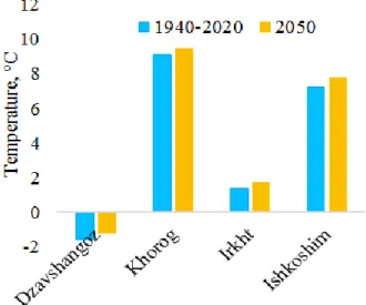
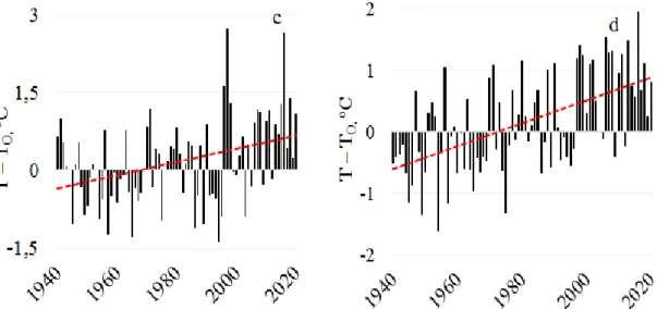
The hydrochemical characteristics of water indicate the climate and environment of the area where the river flows. The Pyanj River is a transboundary river (on the border between the Republic of Tajikistan and Afghanistan) left tributary of the Amu Darya in Central Asia. The dynamics of temperature changes in the Pjanj river basin according to the meteorological station of the basin for the period 1940-2020 is shown in Figure 2.
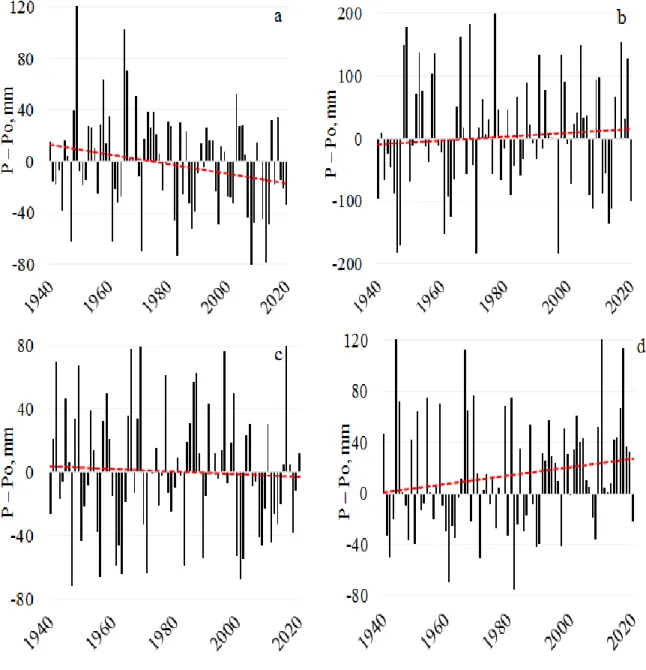
The average annual temperature of the Pyanj River Basin for the period 1940-2020 and by 2050 according to the river basin monitoring stations. The dynamics change to atmospheric precipitation according to the river's meteorological stations Dzavshangoz, Khorog, Irkht and Ishkoshim. The decreasing trend in atmospheric precipitation in the eastern part is believed to be due to the dry air mass inflow.
The relative contributions of the four different water sources in rivers are likely to change in the future.
Formation and dynamics of changes in the hydrochemistry of the Gunt and Pyanj rivers
Precipitation patterns will change and temperatures will rise, which will reduce the contribution of snowmelt and especially glacier melt. Although more than 50% of the glacial ice volume will remain, they will be at higher elevations, so melting will be lower. Based on the assessment instruments developed for the regions, the total demand for water in the Amu Darya basin will increase by about 4%-5%.
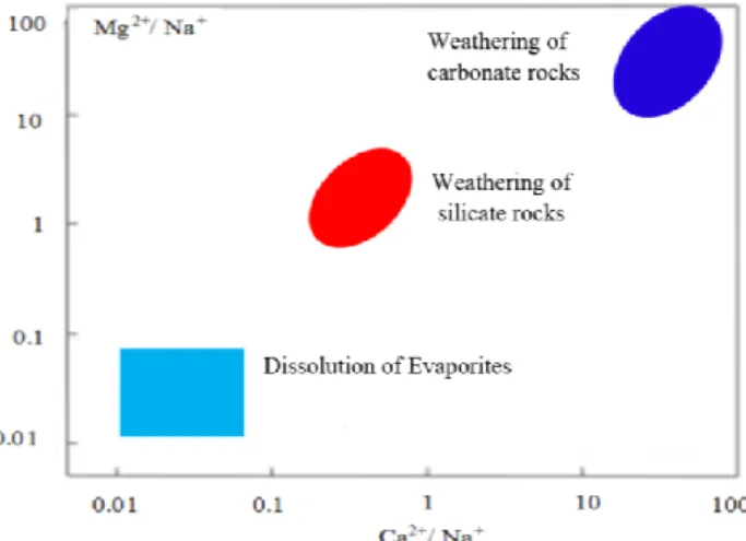
Salinity of irrigation water can lead to the accumulation of salts in the soil layers above the threshold level and the impact on crops of osmotic and ion toxic effects (Rengasamy, 2018). Irrigation of soils with saline water leads to a high level of adsorbed sodium in soils and deterioration of the soil structure with a decrease in infiltration and water movement and insufficient aeration (Munns et al., 2008). The rocks' contribution to the chemical composition formation of natural waters is regulated by the criterion according to which the dominance of the carbonate rocks weathering, i.e.
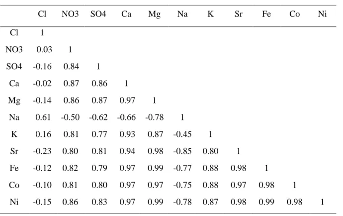
According to the results presented in Table 1, it becomes obvious that the formation of the chemical composition of the Grunt River is due to the weathering of silicate rocks. Rock weathering and evaporite zones correspond to the area of the diagram where the Na+/(Na++Ca2+) ratio is about 0.5 and high, respectively (Neogi et al., 2017). The results of studies of the ratio of cations and anions in the Gunt and Panj rivers, summarized in Table 2, show that SO42-, Ca2+ and Mg2+ have positive correlations (R> 0.66).
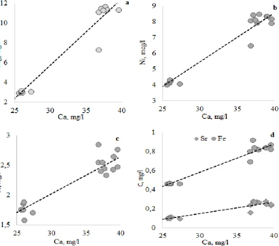
DOI: https://doi.org/10.7454/jessd.v5i1.1086 37 Table 2 also shows that there are many positive mutual correlations between the water composition elements of the Pyanj River and its tributary, the Gunt River. Correlation of magnesium (a), nickel (b), potassium (c), strontium and iron (d) cations with the content of calcium cations in the Gunt and Pyanj rivers. An indicator for determining the contribution of each of the three factors of rock weathering (silicate, carbonate and evaporite dissolution) is the Ca2+/Mg2+ ratio, a high value of which indicates the predominance of bicarbonate weathering (Pandey et al., 1999). .
Dominance areas of the chemical elements input sources to rivers depending on the ratio between Ca2 + and. Using the Gunt River alkali and alkaline earth cation concentrations in the table. Since bicarbonate weathering, which follows from fig. 7, is observed at the values of Ca 2+ /Na + and Mg 2+ /Na + ratios greater than 10, indicates the dependence obtained in fig. 8, that the chemical composition of the Gunt river water occurs due to weathering of the silicate rocks.
The applicability indices of the Pyanj and Gunt rivers water for irrigation
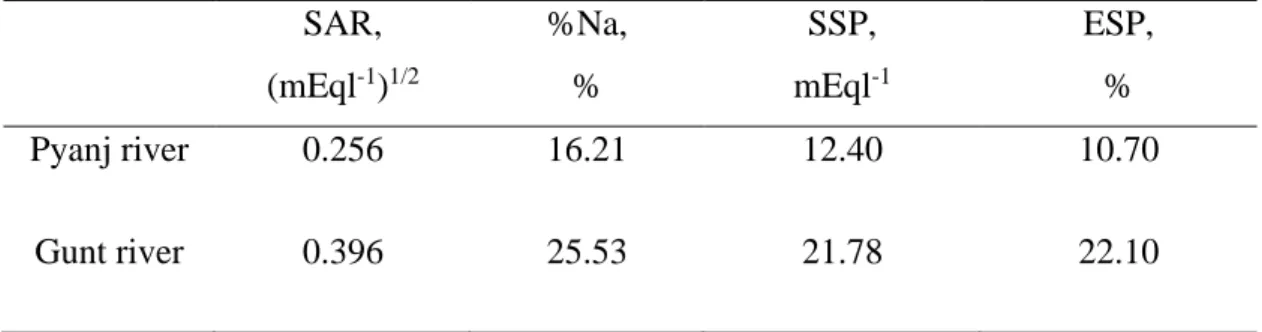
The results of calculation of SAR, %Na, SSP and ESP for the Pyanj and Gunt rivers are summarized in Table 3. Comparison of the results with the classes of the irrigation water quality classes SAR, %Na, SSP and ESP shows that the natural waters of the rivers belong to the "excellent" category. Irrigation water quality SAR, %Na, SSP and ESP for Pyanj and Gunt rivers SAR,.
Conclusion
The results of the calculations and their comparison with the irrigation water quality classes showed that natural river waters belong to the category favorable for irrigation. The authors would like to thank Abulkosim Muminov, Head of the Agrometeorology Department of the Hydrometeorology Agency of the Republic of Tajikistan, for providing data and consultation. Inom Normatov - formulation of goals and ideas, research methodology, theoretical interpretation of results, preparation of the paper writing scheme and discussion of results Akobir Karimzoda - management of literature search and compilation of literature review on the topic of the article, provision of chemicals, participation in discussion of results.
A new approach for the assessment of groundwater quality and its suitability for irrigation: a case study of the Korba coastal aquifer (Tunisia, Africa). Water quality, potential conflicts and solutions—an upstream-downstream analysis of the transnational Zarafshan River (Tajikistan, Uzbekistan). Impact of irrigation management practices and water quality on maize production and water use efficiency.
Application of water quality and dissolved oxygen indices as indicators for river water classification and urban impact assessment. Hydrochemical composition and potentially toxic elements in the Kyrgyz part of the Chu Talas transboundary basin, Central Asia. Introducing a water quality index for the assessment of water for irrigation purposes: A case study of the Ghezel Ozan River.
Social and ecological aspects of water resources management of transboundary rivers of Central Asia. Monitoring of extreme water factors and study of anthropogenic load of industrial facilities on water quality in the Zeravshan river basin. Changes in the hydrological parameters of the Zeravshan River and its tributaries depending on meteorological conditions.
Application of chemical and isotopic methods to assess the risk of pollution of the main tributaries of the transboundary Amudar River. Assessment of the impact of climate change on snow and ice resources and the hydrology of Pamir mountain rivers. Hydrochemistry of the mountain Pamir: Tributaries of the cross-border river Pjanj and the use of their water for irrigation.
A study on groundwater geochemistry and water quality in the stratified aquifer system of Pondicherry region, Southeast India. To investigate the effects of point source and non-point source pollution on the water quality of the East River (Dongjiang) in South China.