ATOLL RESEARCH BULLETIN NO. 379
ISSUED BY
NATIONAL MUSEUM OF NATURAL HISTORY SMITHSONIAN INSTITUTION
WASHINGTON, D.C., U.S.A.
JANUARY 1993
8
A R A B I A N G U L F
2 5' G U L F O F O M A N
0
P o y r n o n i y o t I s s .
0 M A N
S A U D I A R A B I A I 1
\
\ D h o f a r ( Z u f o r )
\
i
A R A B I A N S E A18
K u r ~ o M u r ~ o I s s
Figure 1. Sultanate of Oman and surroundmg waters. After the topographic map of Shell NIarltets (Middle East) Ltci., 1977, scale 1: 1,000,000. Mountains (hatched areas) only shown for Oman.
Plate 1. Satellite-derived sea surface temperature (SST) fields off Oman. (a) Eastern- most Arabian Peninsula with a marked SST gradient along the Gulf of OmadArabian Sea boundary; (b) Masirah Island with high SSTs in Masirah Channel and the northern Gulf of Masirah. An SST scale ("C) is provided with each image. [P.W. Glynn]
ONSOONAL UPWELLING AND EPISODIC ACANTHASTER PREDATION AS PROBABLE CONTROLS OF CORA
BY
PETER W. GLYNN
Fringing and patch cord reefs are present on ian Persian) Gulf shores of northern Oman (Musandam) and in the man, notably off the Daymaniyat Islands and in the Capital (PiIuscat) area. Coral reefs are generally absent from the Arabian Sea coast of southern Oman, most likely a result of monsoon-induced upwehng. However, fringing reefs are present on the northwest (leeward) side of Masirah Island and on the mainland opposite, both areas that are partly sheltered from open coast upwehng.
Aeartthaster plan& was observed ir, the coral rich Gulf of Oman only, where it caused widespread and selective coral mortahty during a population outbreak. Starting in 1978-79, with duninishicg effects to 1982, coral reefs
~ 4 t h high acropoiid coral cover experienced high mor ies with virtually a l l Acropora spp. eliminated on any reefs. Reefs high p ocillop o ~ i d coral cover largely escape y redation, probably use dcanthaster
ulties in traversing continuous stands of this cord: the ts and the presence of symbiotic crustacean guards deter the starfish. Thus, w re en-~ronmental conihtions are suitabl
development, sporadrc, igh level Acan thasier redation can rno
community structure through the rvival of coral prey and hence lead to the development of Acanthaster resistant reef types.
*
Division of Marine Biology and Fisheries, Rosenstiel School of Marine and Atmospheric Science, University of Mzami, 4600 Rickenbacker Causeway, Miami, Florida 33 149- 1098.Manuscript received 17 November 1992; revised 27 Januaq 1993
INTRODUCTION
This paper grew out of surveys conducted in t h e Sultanate of Oman to assess damage to coral reefs caused by the starfish corallivore Acanthaster p l a n c i (Linnaeus). The Ministry of Agriculture and Fisheries (NL4.F) received reports during 1978-1980 indicating t h a t population outbreaks of A. p l a n c i were causing high mortalities among reef corals in the Daymaniyat Islands and along the coast near Muscat (Gulf of Oman), also known as the Capital area (Figure 1). Since so little was known of the extent of coral community development and the distribution of A. p l a m i in Oman at t h a t time, the MAF decided to extend the survey to four other areas in Oman, i n c l u h n g (1) the Musandam Peninsula a t the southern end of the Arabian (Persian) Gulf, (2) Ra's al Hadd (east of Sur), which borders the Gulf of Oman and Arabian Sea, (3) Masirah Island, and (4) the coastal area of Dhofar (Zufar), the latter two areas in the Arabian Sea.
When the present field stucbes were conducted in 1982 the only information available on Omani corals was t h a t in Rosen (1971) and Cornelius et al. (1973), both of whom reported on corals in the Musandam Peninsula region. Fifteen reef-coral genera were listed by Rosen (1971), and Cornelius et al. (1973) claimed that 'true reefs', i.e. structures with significant framework development, were absent from this region. Stoddart's (1971a) synoptic map of the distribution of coral reefs in the Indian Ocean shows coral reefs present only in the Capital area and along the Arabian Sea coast of Oman.
Several important s t u h e s on the corals and coral reefs of Oman have appeared since the early 1980s. In the UNEPJlUCN (1988) handbook of Coral Reefs of the World (vol. 2), 11 s t u h e s were listed that dealt with reef corals fro111 the coastal areas of Oman. These papers were published mainly as technical reports between 1983-1986. The s t u h e s of Green and Keech (1986), Glynn (1987), Shcppard (1988), and Sheppard and Salm (1988), generally more accessible than the technical reports, provide information on the general biology, systematics and ecology of Omani corals and coral reefs.
More recently, Shepyard et al. (1992) present a general account of coral reef ecology i n the Arabian region, and the following article by Salm (1993) in this issue offers new information on various hsturbances to coral reefs a n d the extent of reef development along the Arabian Sea coast of Oman.
Coral communities and coral reefs in the Gulf of Oman a n d Arabian Sea experience upwelling. Strong upwelling impacts corals and restricts reef development. For example, coral reef development is limited or absent i n upwelling areas in the eastern Pacific (Dana, 1975; Glynn and Wellington,
1983), Marquesas Islands (Ladd, 1971; Sournia, 1976), a n d off equatorial west Afiica (Laborel, 1974) and the Venezuelan coast (Antonius, 1980).
When sea water temperatures fall below about 18°C for a n extended period (2-4 weeks or longer) corals suffer partial or total tissue death (Glynn a n d Stewart, 1973; Birkeland, 1977; Glynn and D'Croz, 1990) a n d can be competitively displaced by mauoalgae, which usually show accelerated growth as a result of increased nutrients. The elevated nutrient concentrations in upwelled waters around coral reefs (Sournia, 1976), as well a s in waters bathing many high latitude reefs (Johannes et al., 1983;
Hatcher, 1985, 1991; Coles, 1988), favor the growth of phytoplankton a n d macroalgae. Although the monsoonal upwelling system of the Arabian Sea coast of Oman h a s been well known in general terms (Currie et al., 1973;
Bruce, 1974), only during the past decade have s t u h e s revealed detailed patterns of coastal upwelling (Elliott and Savidge, 1990; Savidge et al., 1990;
Brock and McClain, 1992; Brock e t al., 1992). This study contrasts thermal environments in the Gulf of Oman and Arabian Sea, derived from long-term ship measurements and recent remote sensing observations, to reveal the influence of upwelling on the spatial distribution of Omani coral reefs.
Several recent studies have demonstrated a strong effect of Acnr~thnster predation on Indo-Pacfic coral communities, especially a t high corallivore population densities (Fotts, 1982; Moran, 1986; Glynn, 1990a).
The effects of Acnr~tlznster on corals in Oman were unknown before the 1980s. I observed relatively large numbers of Acnr~tlinster in the Gulf of Oman in 1982, evidently the remnants of a population outbreak t h a t occurred there between 1978-50. From observations of extensive, recently killed corals and the feedulg activities of Acaizthnster, this predator can exercise a strong influence on coral survivorship i n some areas of Oman.
Further, prey selectivity data revealed t h a t Acn?~tJznster also can have a significant effect in altering the species composition of coral communities (Glynn, 1987). In this payer, I will evaluate the relative importance of upwelling and predation respectively i n regulating coral community structure and in controlling the &stribution of c o r d reefs under upwellrng and non-upwelling conhtions.
METHODS
The coastal surveys in Oman, from the Musandam Peninsula i n the north to the Dhofar Province in the south (Figure l), were conducted from 20 September to 25 October, 1982. Coral habitats were located with the help of personnel from the MAF, by local fishermen and sports hvers, from
hydrographic charts, by surveying shorelines from elevated sites
(hill
tops a n d towers), a n d by aerial reconnaissance. Work underwater was carried out by surface &ving and scuba during daylight hours from small boats t h a t could be maneuvered near shore. The nat ur e a n d extent of coral cover, a n d t h e physical &mensions of coral framework construction were determined a t each station. Only crude estimates of reef framework thickness were obtained. On small, t hi n reefs t h e thickness of coral buildups was estimated visually a n d by modest surface excavation. On larger reefs, the depth range of vertical buildups was estimated from the depth differences of t h e reef crest or reef flat and the reef base, measured with a standard, cahbrated depth gauge. Bottom areas were measured with a chain marked a t I m intervals.Field sketches of some reefs were made, which emphasized coral zonation a n d vertical relief. Reef hme ns ions also were estimated from near-vertical aerial photographs taken a t 600 m elevation. The sizes of reef features i n t he aerial photographs were determined from ground-truth measurements a n d with reference to &stance scales on hydrographic charts.
Wainwright's (1965) &stinction between coral communities a n d structural coral reefs was followed i n this study. T h a t is, coral formations were recognizecl as t rue reefs when i t could be determined t hat corals, calcareous algae a nd other associated organisms were actively contributing to t h e accumulation of interlocking framework structures. These structures form significant topographic features, which result from t h e skeletal accuinulation of modern calcifying organisms (Stoddart, 1969). No Pleistocene reef structures were found i n this study. The recognition of coral reefs by Sheypard a n d Salm (1988) was more restrictive t h a n t he above, requiring the presence of a "...characteristic reef topography of a horizontal reef flat at low tide and a reef slope.". I prefer Wainwright's (1965) definition because several relatively large coral buildups observed i n this study ( thick, 1-2 ha) lacked obvious reef flats, but otherwise would qualify as true structural reef lorinations.
Coral species composition and percent live cover were d e t ~ r m i n e d from ain transects a n d frorn 0.25 1n"oint quadrat counts. Chain transects (with 1.4 cm links) were positioned along isobath contours in all coral zones (Porter, 1972a). Chain transect sampling intervals of 5, 10 a n d 15 m were used depenchng on reef widths. Also, G to 7 transects (with 710 sampling points each) were sampled on each reef. Adht ion a1 sampling on reefs was performed with quadrats, each with 16 uniformly spaced sampling points (Glynn, 1987). Usually each reef zone was sampled with 10 haphazardly located quadrats. Species chversity, employing t he Shannon-Wiener index (II', see Pielou, 1977), was calculated for each zone.
Coral species and colony conchtion (i.e., live, eaten, recently dead, etc.), a n d the general substrate type (i.e., algae, sponge, soft coral, bryozoans, sand, rock, etc.) were recorded. Voucher speci~neils of questionable os unknown
5 species were collected for later identscation (see Table 1). John W. Wells identiGed all specimens except Acropora spp. and this collection was donated to the U.S. National Museum, Smithsonian Institution, Washington, D.C.
Carden C. Wallace identdied Acropora species and these were deposited i n the collections of the Queensland Museum, North Queensland Branch, Townsville, Australia. A total of 75 sites were surveyed in this study. Their locations, enumerated chronologically, are shown i n Figures 2-7. Site 2 4 (Ra's a s S a w a h ) was located about 85 km west of Muscat. Surface sea water temperatures were measured with a cahbrated mercury thermometer a t Arabian S e a sites, and horizontal water visibility a n d sea state also were noted.
Adult Acar~thaster were located by swimming over coral substrata and searching under corals and in other cryptic habitats. The search effort was intensified in areas with presumed feeding scars. No other corakvore was f o ~ m d in Oman that produces a f e e h n g scar similar to that of Acanthaster.
An
effort was made to find juvenile Acarlthnster by searching with scuba inFigure 2. Location of sites surveyed on the Musandam Peninsula, northern Oman. From chart of Oman and United Arab Emirates (Kumzar), scale 1:100,000, series I(668, e h t i o n s 4-GSGS and 2-GSGS. Director of Mditary Survey, Ministry of Defence, United Kingdom, 1975.
Table 1. Zooxanthellate scleractinians identified from voucher specimens collected a t the various localities indicated. M, rn Musandam; C, Capital area; R, Ra's Abu Da'ud to h ' s a1 Hadd; MR, Masirah; D, Dhofar.
Locali tv
Family Species M C R MR D
Thamnasteriidae Psammocora contigua (Esper) Pocilloporidae Pocillopora damicornis (Linnaeus)
Stylophora erythraea von Marenzeller Stylophora pistillata (Esper)
Stylophora pistillata (Esper) mordax (palmata) form Stylophora subseriata (Ehrenberg)
Acroporidae
Agariciidae Siderastreidae
Acroporn aspera (Dana) Acropora cytherea (Dana) Acropora glauca (Brook) Acropora cf glauca (Brook)
Acropora haimei (Milne Edwards & Haime) Acropora nasuta (Dana)
Acropora pharaonis (Milne Edwards & Haime) Acropora cf selago (Studer)
Acropora valida (Dana) Acropora sp.
Astreopora myriophthalma (Lamarck) Montipora cristagalli (Ehrenberg) Montipora effusa (Dana)
Montipora foliosa (Pallas) Montipora gracilis Mlunzinger Montipora laevis Bernard Montipora scutata Bernard Montipora tuberculosa (Lamarck) Montipora venosa (Ehrenberg) Montipora cf. M. multiformis Bernard Montipora cf. M. solanderi Bernard Pavona angularis Mlunzinger Pavona cnctus (Forskaal)
Anomastrea irregularis von Marenzeller Coscinarnea aonile (Forskaal)
Siderastreidae Poritidae
Faviidae
Table 1 - continued M C R MR D
Siderastrea lilacea H u n z nger
+
Goniopora savignyi Dana Porites cylindrica Dana Porites columnaris Klunmnger Porites solida (Forskaal) Porites cf. P. cocosensis Wells Cyphastrea chalcidicum (Forskaal) Cyphastrea nicrophthalma (Lamarck) Cyphastrea serailia (Forskaal)
Echinopora hirsutissima Milne Edwards & Maime Echinopora lamellosa (Esper)
Favia favus (Forskaal) Favia pallida (Dana)
Fauites abdita (Ellis & Solander) Fauites conplanata (Ehrenberg) Fauites pentagona (Esper)
Favites cf. di: spinosa (Klunzinger) Leptastrea transversa Klunzinger Platygyra rustica (Dana)
Platygyra sinensis (Milne Edwards & Haime) Plesiastrea versipora (Lamarck)
Merulinidae Mussidae Pectiniidae
Hydnophora exesa (Pallas)
Hydnophora microconos (Lamarck) Acanthastrea echinata (Dana)
Symphyllia radians Milne Edwards & Haime
Oculinidae Galaxea astreata (Lamarck)
+
Echinophyllia aspera Ellis & Solander Oxypora lacera (Verrill)
Dendrophylliidae Turbinaria crater (Pallas)
+ +
Turbinaria peltata (
+
Turbinaria cf. 7'. calicuJaris Bernard
+
4
38 .
f',
', shoal,.
I 82
7u M
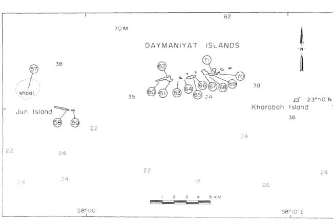
D A Y M A N I Y A T I S L A N D S
- N
I
Jun lslond2 2
K h o r a b a h lslond
Figure 3. Location of sites surveyed i n the Daymaniyat Islands, Gulf of Oman. Map sketched and enlarged from chart published by D Survey, scale 1:100,000, Ministry of Defence, United f i n g d o m , 1971. Soundmgs (in from marine chart 2851, Masirah to Ruus al Jibal, Admiralty, London, 9 May
1952.
the small cavities of live and dead cords, by searching i n coral rubble, a n d by hfting and examining t h e undersurfaces of large, live a n d dead corals. The search effort was recorded in man-hours. Starfish t h a t could be H i e d from t h e substrate were measured i n a relaxed state with a cm rule. Both total (arm tip to arm tip) and d s c h a m e t e r s were measured. Coral species prey were noted a n d 80 point counts of potential prey i n the vicinity of feedmg Acar~thaster were recorded as described in Glynn (1987).
Sea surface temperature (SST) data from Nansen casts, spanning the period 1933-1979, were obtained from the National Oceanographic Data Center (NOAA), Washington, D.C. The temperature measurements were generally recorded to the 0.01 place a n d probably have a minimum precision of
*
O.l°C. Monthly SST plots were constructed by manual contouring.I
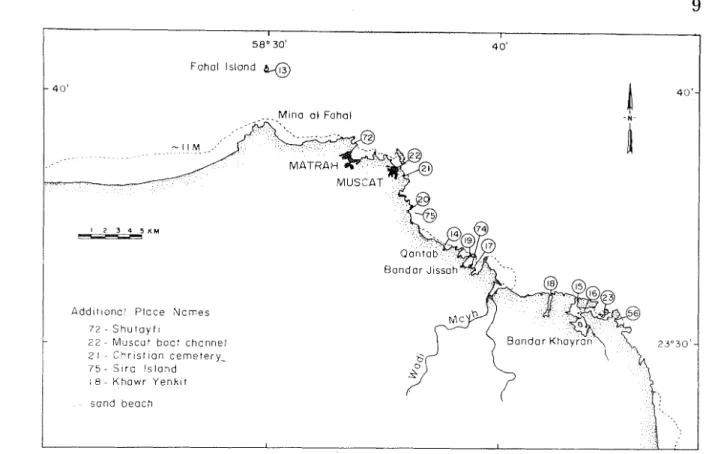
Fahal Island %Figure 4. Location of sites surveyed in the Capital (Tvluscat) area, Gulf of Oman. Dark patches a t Matrah and Muscat i n h c a t e areas of high population density. After Admiralty Chart 3522, Gulf of Oman, London,
1967.
Satellite infra-red data from 1988 and 1989 were analyzed to reveal near-shore SST patterns and the location of thermal fronts during the summer monsoon season. The time series includes observations from late May to late September, obtained from the Advanced Very High Resolution Radometer (AVHIZR), Local Area Coverage (LAC) data. SST was calculated using a multispectral algorithm described by McClain et al. (1985). These data are archived in the Division of Meteorology and Physical Oceanography, Rosenstiel School of Marine and Atmospheric Science. The NOAA satelhte carrying the A W R R was located in a sun-synchronous polar orbit with ascenhng passes a t approximately 0300 and 1500 (* 50 min.) local s u n time.
The early morning passes usually provided the clearest images.
All
SST imagery was mapped to a fixed geographic grid covering the area 55-64"E,18-26"N with a spatial resolution of approximately 2 km. Detailed analyses were confined to 1" square grids centered over Masirah Island and the Muscat area, and a 6" rectangular grid centered over the Gulf of Oman-Axabian Sea boundary [see Remote sensing data (1988, 1989) below].
L E G E N D M o u n t a ~ n s
CZB 2 l,OOO M
eza 2 2 , 0 0 0 M
- N -
Fig-ure 5. Location of sites surveyed from Ra's Abu Da'ud t o Ra's a1 Wadd, Gulf of Oman. From charts of IQuscat and Sur, scale 1:250,000, series 1501, e h t i o n s 3-GSGS. Director of Military Survey, Ministry of Defence, United Kingdom, 1975.
Excludmg periods of high cloud cover, the analysis included 47 days each over Muscat and Masirah in 1988 and 58 and 6 1 days respectively over Muscat a n d Masirah in 1989. The total number of images analyzed over the boundary zone was 42 in 1988 and 58 in 1989. Color transparencies were obtained from the SST color images and the positions of thermal fronts a n d upwelling areas were mapped from these onto acetate film overlays.
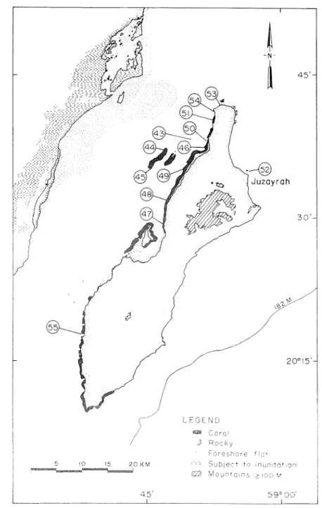
Figure 6. Location of sites surveyed a t Masirah Island, Arabian Sea. From chart of A1 Masirah, scale 1:250,000, series 1501, edition 2-GSGS. Director of Milit m y Survey, hlinistry of Defence, United Ihngdom, 198 1.
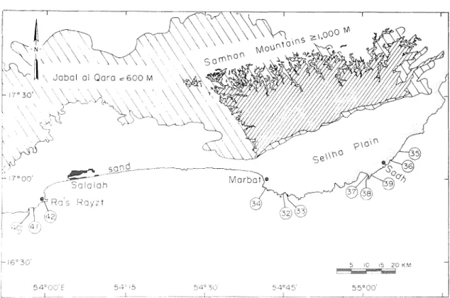
Figure 7. Location of sites surveyed i n the Dhofar area, h a b i a n Sea. Dark patch a t Salalah indicates ar ea of high population density. From chart Salala (= Salalah), scale 1:250,000, series 1501, e k t i o n 2-GSGS. Director of hhhta ry Survey, Mii1istl.y of Defence, United Kingdom, 1980. Elevation of al Q ara Mountains from Map of Oman, The Sultanate of Oman (2nd ed.
revised, 1983), ?Malt Tntemational, P.O. Box 8357, Beiru4, Lebanon).
Distribution and Natu1.e of Coral Communities and C o l d Reefs
Esancla~n. Iiamose and table Acropora species predominated i n the areas investigated i n the Musandam, although Pavorzcr, Porites, Gorziopora, Mor~tipor*a, and Pocillopora species also were patchily abundant. The occurrence of coral formations was sporadx, b u t where preseilt live coral cover tended to be high (often
r
60%). Zoosanthellate corals ranged in depth from about the estreme low water tidal datum to 10-12 in. Numerous coral species were present a t five sites (1, 3, 6 , 10 and l l ) , but no reef development was evident. IZecf fmme construction, ranging between 2 a n d 4 m (masimum) in relief, was observed at sites 2, 4, 5, 7, 8, 9 and 12 (Figure 2). Aminimum of 22 reef-building coral species were present a t t he 12 sites (Table 1) -
A small, b u t well developed fringing reef was present on the east side of the bay a t Khasab (site 2). The water was turbid, due to wind-generated waves t h a t suspended fine calcareous s e h m e n t s , with maximum lateral visibihty of 5 m. Massive Porites colonies dominated coral cover on the reef flat a nd from surface views seemed to contribute importantly to reef slope construction a s well. The majority of the Porites colonies on t h e reef flat were dead, a n d these were interspersed with live species of Platygyra, Favia a n d Fauites. Many of the corals on the reef flat were covered with fine sediment.
Species of Acropom, Goniopora, Plcrtygyra, a n d Stylophora pistil1ata"ere present on the reef slope. A few large (1-2 m hamet er ) colonies of Acropora cytherea were present on the upper reef slope. Corals thinned out a t 4 rn depth on a gently sloping s a n d bottom. XiIaximum relief of this reef was between 3-4 m.
Coral cover was high within the inner reaches 01 the fjord-like inlets (sites 4-6, 11 and 12) where winds and wave action were reduced a n d water visibility increased to about 10 m. F r i n ~ 4 n g reefs were present a t sites 4 and 5 with m a s i ~ n u m reef frame relief of 2-3 111. The reef flats were only 4-5 m i n width and bordered deeply notched (1-2 m), limestone cliffs. The notches were a t mid-tidal elevation a nd presumably formed by lithophagine bioerosion a n d s a n d scouring (Cornehus et al., 1973). Corals were h s t r i b u t e d sparsely on no st reef flats with t he following genera observed:
Cyphastrea, F a ~ l i a , Fauites, Go7tiopora, Pavoua, P l a t y g 2 ~ a , a n d Porites. The forereefs in this area exhibited 80-190% cover of Pauona cactus, and this cox.al was a b u n d a n t fi,om the uppey reef slope (2 m) to 10-12 an depth. Some branching Acropora species also n-ere present on the upper reef slope.
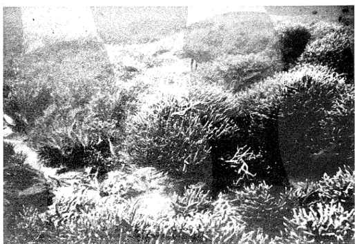
Coral species cichness appeared highest a t sites 7-63 (Goat Island or Jaz ira t el Ghanam). Branching and tabular Acropora spp. were abund ant (Figures 8 a nd 9). Several
-4.
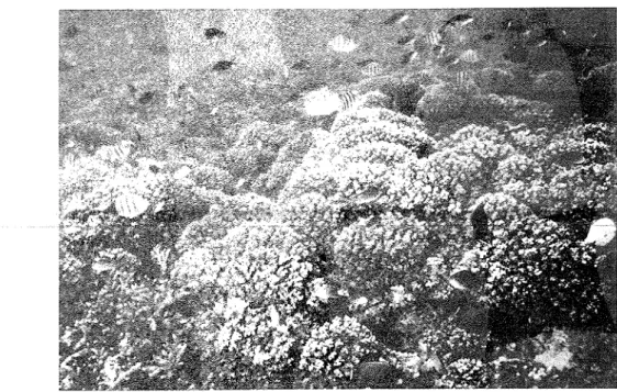
cytherea colonies 1-1.5 m in h a m e t e r were observed a t site 7. Some massive Porites colonies attained 4 m in height. At site 8, monogeneric thickets of branching Acropom s11p. formed 1-3 m thick coral franleworlis (Figure 8). Also a t site 8, virtually monospecific stands of Pocillopora damicor7lis formed reef frameworlis t h a t were 3-4 111 thick (Figure 9). A few scattered colonies of Porites solida were present within the pocilloporid patch reefs. The acroporici a n d pocilloporid reefs, usually centered between 1 ancl 5 111 clepth, covcred about 0.5 h a each. Deudrophyllia*The authors of the scientific names of coral species identified in this study are provided in Table 1.
Figure 8. Underwater view of Acropora spp. corals, Musandam Peninsu%a, site 8 (Fig. 2), 4 111 depth (2 1 September 1982).
Figure 9. Underwater view of a dominantly PocilLopora darnicorrtis build-up, Musandam Peninsula, site 8 (Fig. 2), 4 m depth (21 September 1982). This patch reef was approximately 0.5 h a a n d h a d a maxin1um reef frame thickness of 3-4 111.
micra,l.tlza (Ehrenbeihg), a nd other azooxanthellate~corals, were abundant on partially shaded liinestone boulders a t 1-3 m depth. Numerous species of reef corals continued down slope to a s a n d bottom a t 10-12 m depth.
No Pocillopora spp. were seen a t sites 1-6, b u t numerous colonies of P.
darnicornis were present i n several coral communities a t sites 7-12. Several of t h e latter &splayed conspicuous bleached (whitened) branch tips.
Occasionally a few colonies of Pocillopora uermcosa (Ellis & Solander) with stout branches a nd h s t i n c t verrucae also were found.
Coral coininunities a t sites 7, 9, 11 a n d 12 appeared to have been subject to repeated rock slide (listurbances. Large sections of steep limestone cliffs bordering the shoreline often collapsed, resulting in rock piles t h a t covered the adjacent submarine shelf. Inspection of the undersides of rocks revealed crushed corals. Some of the older blocks were overgrown by corals, inchcat ing successful recolonization and growth following rock slide events.
Schools of hcri3ivoi'ous fishes (e.g., scarids, acanthurids and liyphosids) or large I.nvei~tebrate p d a t o r s (e.g., tetraodontids, &odontids and baiistids) were conspicuously absent. Large numbers of small predators, e.g. labrids, pomacentrids and haeinulids, were abundant (Figures 8 and 9). A few large Eztcidaris metrr,la~ia (Lamarcli) occasioilally were observed on the live bi*anches of .4crcpora corals, but there was no indication that they were fee&ng on coral tissue. h!licrofila~nentous algae comprised the chief ep ibenthic plant cover, which are characteristic of reef habitats with reduced herbivory and low nutrient levels (e.g., Hatcher, 1983; Littler and Littler,
3984; Berner; 1990).
i l 1 . 5 J c f o,~iot~c. :;l.loi~ t ~ ~ i o r t r , I'oczllopom and Porites
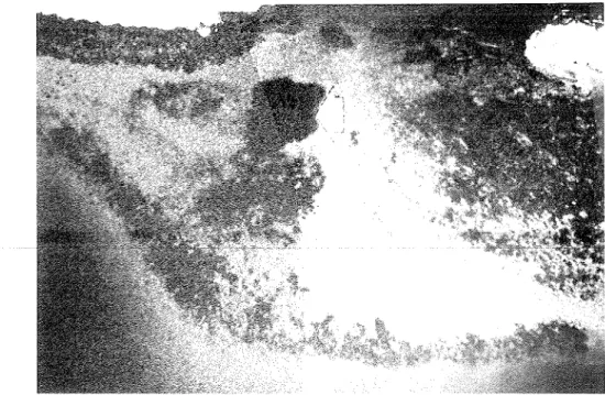
q~e:.lc>ci o c c u r ~ c d ; ~l jwirImt lj at mobt s ~ i e s in t hcl Dayinaniyat Islands (Figure 3). =-'icropc~,~a c j ~ i l z ~ w l d - 2 tn t b ameter colomcs, ~ v e w prominent yet dl of these large culomes wcre dead (Figuws 10-13). The majority of these corals tvere in 1101~111al growth position and were overgrown with niicrofilamentous algae, hytlroids, alcyonaceans and bryozoans. Poc~llopo?-a danzicornis often was observed gron-ing on the upper surfaces of dead A. cytllerea (Figures 10 and 13). Also seen on dead -4croporct were small (< 30 cnl &aineter) colonjes of St~'Lop1lom sp ., P o r ~ t e s sp., I I C ~ O ~ O I T Z SP. and S y ~ n p l z y l lia r a d i a n s . The only notable large colonies t h a t still exhibited patches of living tissue were Porites, n-hich were tentatively identified as Porites solida (Figure 10).
Where Acro,uorcr corals p~edoniinated, live cover was low (I 1%). Most bottom areas where Pocillopom and Poritc's p r e d o m i n a t ~ d exhibited relatively few dead colonies and showed high live coral cover ( 2 50%, Fig-ure 13). m x e d ,4o~opo~~t~-Pocillo~1o~~ci colnnlunities, with nearly all Acropora dead and all
Figure 10. Underwater view of a dead, redominantly A c r o p o m spp. c o r d community, Daynaaniyat Islands, site 58 p i g . 3), 4 na depth (20 October 1982). Note live Pocillopora darnicomis colony resting on top of a dead Acropora coral (center c;f photog~apla).
Figure 11. Near-vertical aerial view of leeward side of J u n Island, site 58 (Fig. 3), Daymaniyat group (ca. G O O 111 elevation, 18 October 1982). Dark, broken patches along shelf edge (bottom) and elsewhere represented mostly dead A c r o p o m spp. communities. Dark, solid, trapezoidal patch (arrow) was a live Pocillopora dctr~licorxis build-up.
Figure 12. Near-vertical aerial view of island east of J u n Island, site 59 (Fig.
3), Daymaniyat group (ca. 600 m elevation, 18 October 1982). Dark patch on shelf edge (ar1,ow) was a live Pocitlopora d a r a i c o m i s build-up, dark patches on shelf coilsisted predominantly of dead A c r o l ~ o r n spp. communities.
Pocilloporn alive, indicated a marked hsproportionately higher mortality of acroporid species.
Live corals occurred at a maximum depth of about 15 m, where light levels were high. Underwater visibihty was high a t all sites, approximately 20 m laterally. Patch and fringing reefs were well developed along t h e lee (south) sides of t he island chain (Figures 11 and 12). Fringing reefs were present a t sites 58 a n d 70. Massive Porites sp. were most abundant on t h e reef flats a n d shallow sections of these reefs, whereas Pocillopora darnicornis tended to predominate on the deeper slopes to a calcareous s a n d bottom a t 5-6 m depth. A shallow (1-2 m de th) moat between the leeward reef flat a n d shoreline was populated with Platygyra, Stylophora, branching Porites, Mon,tiporn, a nd Acropora a t site 58. The framework relief of fringing reefs was approximately 4-5 m.
The dead A C ~ , O ~ O K L patch reefs were present a t s h a l l o w depth (2-5 m).
Their vertical franleworli construction was slight, from about 1 to 3 m only, suggesting a poutllful stage of development. These dead reefs, each covering several thousands of square meters of bottom, were observed at sites 58, 60, 63 and G S . Porltes fringing reefs showed a vertical relief of 4-5 m, a n d t he larger pocill oporicl patch reefs ap eared to have a relief of 6-7 m. The p ocillop orid reef's, virtually monospecific stands of Pocillopora clamicornis, were present on insular shelves (Figure 11) or a t shelf-slope boundaries (Figure 12). Some of t he pocillopoiid reefs were elongate a n d paralleled t he leeward shelf 4-5 m isobath. Such reefs were well developed at sites 59, 61, 66, 67, 68 and 69. Some pocilloporid reefs were elongate and appeared to follosv the 4-5 nl isobaths along the shelf edge. The shelf-edge pocilloporid r e e k descencled gradually into deeper water where they stopped abruptly on a gently sloping calcareous sand glain a t 10-12 m depth. The black balistid I ' I ~ ~ I L C ~ L ~ ~ ~ S ' S i ~ l d i c i i s Itandall & Jilaitsewitz was abundant where holes were
Although wef'building was no , coral comnlunities were we developed at sites 57, G2 and 71. Scattered coi~al knolls constructed by massive I'oritps occurred at site 57. Numerous species occurred a t sites 62 a nd 71 on the north sides of the islands. Wave action there stirred up sediments alld rcducetl lateral visibility to about 10 m. Site 64 was a flat rock bot t 0111 wit 11 scatt el-ecl dead colsal cover.
Cay~t211-are~l. Nearly all of the reef-building coral species present i n
-
the LiIusanclanl and Daymaniyat Islands also were founcl in the Capital area (Figure 4). 'l'lie chief reef frame builders also were similar in the three regions.
A group of rocky islands located immediately offshore of Ra's a s S a w a h , about 85 km west of Muscat on t he southern A1 Batinah coast, was the location of site 24 (Figure 1). The abundant, genera i n this turbid (2-5 m lateral visibility) environment were Acropora, Pocilloporn and Porites.
Acroporn cytheren and Plntygyrn also were observed. Patch reefs composed of branching A c r o p o m a n d Pocilloporn d n n ~ i c o r n i s were present around some of the small islands. The maximum depth of these reefs reached only about 8 m, and maximum vertical relief was 1-2 in. A drying reef flat was present on t h e nlainland coast, composed mainly of massive Porites colonies.
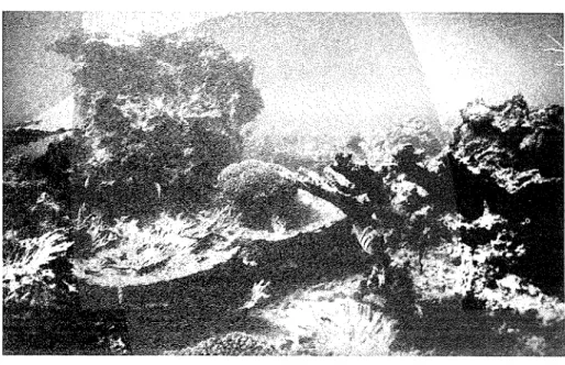
Pocilloporid reefs were well developed a t Fahal Island (site 13) and nea r Muscat (sites 21 a nd 22), where they were present i n areas relatively sheliered fi'oin dwect wave assault. Lateral water visibility ranged between 10-20 m duitng the surveys. These reefs demonstrated high live coral cover (80-100%), were constructed primarily of Pocilloporn dcrrnicorrzis, a n d h a d maximum relief of 6-8 111 (Figures 14 a n d 15). hfaximuin reef depths ranged between 9-10 in.
The yocilloporid reef on the south side of Fahal Island was a t least 1 h a in planar view. The shallowest reef surnmits, with 100% live coral cover, were 3-4 in below sea level and appeared not to have been exposed a t low water. Massive Porites sp. colonies, 2-3 m high, were interiningled vr.ith P.
d n r ~ ~ i c o ~ , , ~ i s framework in some areas. The basal margins of some of the Porites sp. were overgrown by P. d n r n i c o r ~ ~ i s , and a few coloiiies were nearly completely overt,opyed by pocilloyorid f ia~nework. Several large Dindenla s e t o s u ~ ~ ~ Leske n7eue present at. the reef base. The rnainlancl pocilloporid reefs :vex app~oximat.el.>r 0.5 (site 21) a nd 0.8 (site 22) h a in planar vi.ew. The reef flab 011 both ~.eef,s re~,eal.ed considei.abie dead coral, mostly in growth.
position, probably intfj.cat:ive of' exposures a t low tides. Much of this dead coral was overgl,on-n by c r u s t o x corall.ine algae and rilicroG1aiilcntou.s algae.
This was reilecrctl. in the xlat.ivc.!y low percent live E'oocilloporcr cover on r e e f flats c o m y a r ~ d 15-ill1 the seaward slope zone (Figures 16
species chversity was highest at the reef base a t site 21 (HI
occurrence of species of A 4 o ~ ~ t i p o r n , ACT-oporcr, Gor~ioporn, Porites, Psnmrnoco?a. F n ~ ~ i t e s , and Astreopora (Figure 16). The highest H' index a t site 22 (HI = 0.77) was observed 011 the reef flat, where a few Acroporn colonies were present (Figure 17). In general, these reefs revealed sparse pocilloporid rubble at the reef base or on adjacent sand plains. Large D.
setosuru were common at the reef base.
Figure 14. Oblique aerial view of -$lie Christian cemetery embayment, site 2 1 (Fig. 4) (ca. 600 m elevation, 18 October 1982). Dark patch (right of center) is the same pocilloyorid patch reef shown in Fig. 15. Other linear patches skirting t h e shoreline are incipient fiG~ging reefs composed of a variety of coral species.
Figure 15. Unclei*water view of fring-ing pocilloporid reef, Capital area, n ear Christian cemetery, site 21 (Fig. 4), 2 111 depth, 15 October 1982. A school of the Arabian But terflyfish, Chaetodon ~nelnpter.us, is visible in the foreground feednlg on live Pocillopora dcr~rricornis.
s e a w a r d slope
*
basement
'
?1
r o c kI
n o n - p o c i l l o p o r i d corals
Figure 16. Cross-section sketch of a pocdloporid reef near the Christian cemetery (site 21, Fig. 4) from shoreline to off-l-eef s a n d plain (above).
Sampling areas across the reef are denoted by arrows. a n d the corresyondmg p r r c m t live Poc~lloporn dcbnlicorxis cover a n d coral species diversity (
mrlicated m the gya (below). S.1. is a ~ p ~ o x i m a t e l y mean sea level. Data from chain transect sampling performed on 15 October 1982.
Chaetodor~ ~nelcrptcrus Guichenot. the Arabian Butterflylish, often was observed f e e h n g on live P. danzicornis colonies on lnainland pocilloporid reefs ((Figure 15). They appeared to be removing polyps a s do other butterflyfkhes in kfferent areas of the Pacific Ocean (Hourigan et al., 1988).
Only two porcupinefish, Diodorz hystrix Linnaeus, were seen during the entire survey (at site 21). Several other fishes t h a t commonly frequented pocdloporid reefs included: unidentified benthic pomacentrids a n d schools of Abzrdefdzrf saxcltilis (Linnaeus) (Pomacentridae); Cephalopholis miniatzrs
(Forsskal) a n d Cephalopholis argzis Bloch & Schneider (Serranidae);
Ostrclciorz. tuberculatus Linnaeus (Ostraciontidae); R h i n e a c a r ~ t h u s aculeatus (Linnaeus) (BAstidae); Zebrasoma xarlthur-urrr (Blyth) (Acanthuridae);
C a r a r ~ ~ o i d e s fillvoguttatus (Forsskal) (Carangidae); Herziochus acurrzirzatus
s. 1 . r e e f f l a t
Figure i 7. Cross-section sketch of a pocilloporid reef off Jazirat Muscat n e a r the Sultan's Palace (site 22, Fig. 4) from shoreline to off-reef s a n d plain (above). Sampling areas across the ~ e ar e denoted by arrows, a n d t h e f corresp o n h n g percent live Pocillopora da,rnicon~is cover a n
diversity (HI) a re laachcated on t he graph ow), S.I. IS appr sea level. D a t s h o n l quarter meter q sampling 11 O c t o b e ~ 1982.
(Linnaeus) (Chaetodontidae). However, large schools of herbivores (e.g., parrotfishes, acanthurids, kyphosids) were not seen.
Small patches (5 X 20 and 10 X 20 n ~ ) of live P. damicorr~is were present a t Bandar I<hayran (site 1G). These patches were thin with maximum vertical buildups of 1-2 111. Two dead pocilloporid formations were observed a t Bandar Jissah. The larger of these (site 19, between north island a n d the mainland, see hlap 1 in Salm, 1985), about 0.8 h a and 3-4 m high, was broken a p a r t with coral rubble widely scattered. Large sections of this reef were overgrown with microfilamcntous and macroalgae, a n d alcyonaceans. The second dead pocilloporid patch (site 74, south side of island in the central branch of the main bay, Salm, 1985) was i n growth
position. Another dead pocilloporid formation, observed by B. Speck (pers.
comm.) in a bay to the south of Bandar Khayran, was not visited during this study.
Small Acropora patch reefs, usually with a maximum vertical buildup of 1-2 m, were observed immediately west of Qantab (site 14), inside Bandar Khayran (site 16), and in the central branch of the main bay a t Bandar Jissah (site 17). Lateral water visibhty was about 10 m a t these sites.
Acropora cytherea, with larger colonies 2-2.5 m in hameter, predominated a t sites 14 and 17. Most of these corals were dead with several colonies observed being eaten by Acartthaster plarzci (Figure 18). Goniopora sp ., about 1 m hametea. colonies, were also present and h d not show signs of predation by A c n ~ l t h a s t e r . Acropora thickets, with up to 100% Live cover of branching species, were present a t site 16.
Coral reefs with other than acroporid a n d pocilloporid species psedominant weye seen a t four sites. A fringing reef composed of numerous
Figure 18. Underwater view of' Aca~ltlzaster plrrmi resting on a tabular colony of Acroporn cj'tllerecr, 5 m depth, Bandar Jissah, site 17 (Fig. 4), 15 October 1982. Approsirnately one-third of this 1.5 m dmmeter colony h a d been eaten by the three Acrrl~thcrste~. present between the tabular branches.
genera, e.g. Stylophora, Pocillopora, Acropora, Goniopora, Porites and Pavona, extended along the western shore of the large island a t Bandar Khayran (site 15). This reef displayed a vertical buildup of 2-3 m, but the framework ended abruptly a t 5-6 m depth. Several aggregations of Diadema, with 25 to 50 indmiduals each, were present a t the reef base. Thickets of branching Montipora sp. covered 10s of square meters inside Bandar Khayran at site 16. A Porites sp. fainging reef was developed i n turbid water (1-2 m lateral visibility) at Khawr Yenkit (site 18). This reef h a d a relief of 2-5 m. Most of the coral was dead a t 1 m depth. A small, monospeci£ic Goniopora sp. patch reef was present in a sheltered cove a t site 23. This reef covered a 50 X 20 m area, exhibited 100% live cover, and h a d a maximum reef frame relief of 3-4 m.
No reef development was observed a t sites 20, 56, 72, 74 and 75.
However, species rich coral communities characterized sites 56, 74 a n d 75,
dl
of which were subject to rent levels of Acanthasfer edation. The most abundant genera a t site 56 were Pocillopora, StyEopho Porites (incluchng itic and massive species), and an encrusting Aorztipora sp.Acropora were predominant a t site 74, and Pocillopora and Porites a t site 7%.
Ra's Abu Da'ud to Ra's al Hadd. Lateral water kisibhty was only 3-6 m a t sites 25-31 (3-4 October 1982). Plankton blooms were evident at most sites, including large numbers of brown, stinging jellyfish. Few corals were seen a t sites 25-27, northwest of S u r (Figure 5). Species belonging to the genera Pocillopora, Stylophora, Acropora, Porites and Platygyra were observed scattered on cob$
A small patch reef was present just inside e west bay entrance at hCElor al Hair (site 28). This reef was only 2-3 p, and was constructed dominantly of assive Porites and, to a s degree, Gon iopom.
Alcyonaceans clominated sites 2 -31. A few corals belonging to the genera Pocillopora, StyEophora, Acropora, Porites, Gorziopora and Platygyra also were seen. Large encrusting alcyonacean colonies were observed overgrowing and killing some of these corals (Figure 19).
Environmental con&tions changed dramatically a t Ra's Abu Da'ud with clear water (10-12 m visibility) and well developed coral communities prevalent, similar to those reported in the Capital area. Pocillopora dcrmicornis reef buildmg was evident in two areas between an island and the mainland shore. Maximum framework development ranged between 1-3 m.
Bot,h of the pocilloporid reefs contained large dead sections with surfaces t h a t appeared to have been planed. These leveled surfaces were colonized mostly by Acropora spp. and P. damicorrzis, but small colonies of Stylophora,
Figure 19. Underwater view of 'soft corals' (alcyonaceans) i n s p r e a h n g over the substratu and overtopping reef cor
Gor~iopora sp . , 4 m dep t east of Sur, site 30 (Fig. 51, 4 October 1982.
Morztipora and Platygyra also were present. P. darrzicorrzis dominated large sections of the dead reef frame with 100% live cover. In other areas, Acropora spp. were predominant with mangT examples observed of branching and table Acr*oporca overtopping Pocillopora and Stylophora. Some 20-30 cm h a m e t e r gseihlo orid colonies were 1111 erneath and completely s
the acropoxids.
I s l a ~ ~ t J , Reef corals were abuiidant a t Ibasira Bslai~d and the coral ccomn~unities %-ere h ~ s n d along t e northwestern coast (Figure 6). Pocillopora danzicorr~is and Mon,tipor*cr foliosa were among the more abundant species with the following genera also well represented at several sites: Stylophom, Porites, Fauia, Favites, Leptoria, Platygyra, and Acarzthastrea. Relatively few Acropora spp. were seen a t Masirah compared with the Musandam, Daymaniyat Islands and Capital area. The water was highly turbid, with 1-3 m visibhty, at most sites. This was caused by S W winds that continued for several days (maximum velocity 7 knots during site visit), and wave action over the shallow shelf, which resuspended fine carbonate sehments.
Few corals were present a t sites 43 a n d 44, which were inhabited more by macroalgae (e.g., P a d i l ~ a a n d Caulerpa) a n d zoanthids (Palythoa). While a species rich coral community was found a t site 45, most of this patch t h a t is designated a s a coral bottom on the nautical chart (Figure 6) contains few corals. On the west side of Masirah, corals also were sporadically abundant a t sites 47, 48 and 55, but seagrasses and macroalgae (e.g., Caulerpa and Sargassunz) predominated.
Fringing coral reefs dominated t h e coastline from site 49 north to site 54, i n c l u h n g sites 46, 50 and 51 (Figure 6). These reefs were shallow, ranging between 1.5-5 m depth, with maxinlunl vertical framework relief of 3-4 m. Pocillopora damicornis and Morztipora foliosa, either alone or together, were the chief reef-builhng species (Figure 20). Acropora reefs were not observed a t Masirah Island as enoneonsly attributed by Sheppard e t al. (1992) to Glynn (1983a). On reef exposures where internal structures were visible: P. clanlicomis contributed disproportionatcly to the framework with mostly lil-e colonles of M. foliosa populating the dead pocrlloporid framework at the su~i'ace. A 4 foliosn contributed prcdoininantly to the hve
Figure 20. Underwater view of live Mo7~tipora foliosn buildup, incipient fringing reef, 3 ln depth, Masirah Island, site 54 (Fig. G ) , 12 October 1982.
- ' O I
Pocil l o ~ o r o _
-
- -H' I - - - \
\
I \A I
fl\
\ I \
I I \ I \
Figure 2 1. Cross-section sketch of a dominantly pocdloporid reef off t h e west side of Masirah Island (site 46, Fig. 6) from shoreline to off-reef s a n d plain (above). Sampling areas across the reef are denoted by arrows, and t h e correspon&ng percent live Pocillopora damicornis cover a n d coral species diversity (H') are i n d x a t e d on t he graph (below). S.1. is approximately mean sea level. Data from quarter meter quadrat sampling performed on 12 October 1982.
cover a-t sites 49, 50 a-nd 51. At sites $6 and 54,
P.
clnmicornis also was abundant,, especially on t h e seaward slope (Figure 21). t h e r coral genera (e.g., Styloplzora, Acropora, Cyphnstrea, Fnvin, Fnvites, a n d Acnnthnstren) were largely restricted to reef flats where pocilloporid a n d montiporid cover was low. The reef flats i n this area a re exposed during extreme low water (M.A. Al-Barwani, pers. comm.). Large numbers of rock scallops were attached between t he basal branches of live Pocillopora i n the slope zone a t site 50 (Figure 6). The reef framework abruptly ended in a thick carbonate s a n d bottom with few live, intact corals or broken fragments a n d rubble a t the reef base (Figure 2 1).Chnetodon melapterus were observed on most fringing reefs a n d were seen feeding on live Montiporn foliosa, although i t could not be determined w ha t the butterflyfish were feedmg on (e.g. mucus, coral tissues). Schools of
large fish grazers or large invertebrate predators were not observed a t Masirah Island.
At site 55, Sargassum spp. occurred as dense beds a t 0.5-1 m depth, with 1-1.5 m long blades forming a thick canopy. Numerous scattered corals were attached to the dead coral boulders beneath the canopy, i n c l u h n g Psammocora, Stylophora, Montipora, Goniopora, Porites, Cyphastrea, Favia, Favites, Galaxea, Acanthastrea, and Turbinaria. At 1.5-2 m depth, between 100-200 m from the shoreline, the mixed macroalgal/coral community was replaced by crustose corahne algae, which were growing on a thin (0.5-1 m) framework of Montipora. This fringing reef was only sparsely populated by corals, chiefly Montipora foliosa. Farther seaward the unbroken fringing reef became separated into isolated blocks, which eventually thinned out and chappeared.
Coral communities intermixed with macroalgae and seagrasses were observed a t sites 47 and 48. Among the common genera observed were Stylophora, J4orztipora, Porites, Favia, Favites, Leptoria, Platygym and Acanthastrea. The summits of many large colonies of the massive genera (e.g., Porites, Leptoria, and Platygym) were partially covered with carbonate sand. SST and water visibhty decreased markedly around the north end of Masirah, from site 53 to site 52. Only scattered colonies of Stylophora pistillata were observed a t site 53 and Favia and Favites a t site 52.
Macroalgae were predominant a t these sites.
Dhofar. The rocky coast from M a r b a t t o s ghtly east of S a
populated with lu nities of frondose macroalgae (Figure 7). Species of Sargassaceae ta) were especially abundant, their buoyant blades forming a canopy with a dampening effect on approaching swells.
Other abundant brown algae included Bifurcaria s , Cystoseira sp., the kelp Eckloaia radiota (C. Ag.) el. Agar*, P a d i r ~ a s n i urbinaria sp. The red alga Hyprzea rnu,sciforrrzis (Wulfen) mhodophyta) als bundant along with the green algae Caz~lerpa spp. and Ulva sp. (Chlorophyta). For more information on the algal communities and rocky shore fauna in this area, consult IUCN/ROPME/UNEP (1984).
Water visibihty was only 3-5 m a t sites 32-34 near Marbat.
Macroalgal cover was near 100% from the mid-intertidal zone to 3-5 m depth.
Associated with the algae were abalones (Haliotis marine Wood), sea urchins (Echinometra, Stomopneu,stes, Echinostrephus) and unidentified starfish.
Only a few corals were seen shallower than 5 m (Figure 22). Corals increased in abundance between 5 and 10 m with a concomitant decrease in macroalgal cover. Most colonies were small. However, some large colonies
Figure 22. Underwater view of macroalgae surrounding a reef-builhng coral (Platygyra, center), 3 m depth, east of Marbat, site 32 (Fig.
77,
6 October 1982.were present i n c l u h n g species from t he genera Acropora (40 cm diameter tables), Astreoporn (80 cm hameter), Porites (35 cm high massive colonies), Fauites (50-60 cm, longest t h e n s i o n ) , and T u r b i m r i a (75 cm hameter).
Stylop1zor.a pistillcita was common, b u t Pocillopora was rarely seen.
The n-ater coiidrtions and shallow marine community composition near S a d h (sites 35-39) were similar t o those a t &$arbat. Quantitative sampling of the epibenthos to 11 m depth (sites 35 and 39) revealed primarily macroalgal communities. At site 35, Ulun was the predoniinant alga with occasional Sargassum plants also present. Both crustose and articulate coralline algae were often present under the macroalgal canopy. Corals (Acropora a n d Stylophorn) occurred only between 8 and 11 m depth. Sargassurn spp. were the most abundant macroalgae a t site 39. Corals were more common below 5 n~ with Acroporcr, Fcrvites a nd Cyphastrea present to 11 m depth.
r o c k y p l o t f o r m '
\
0 5 I O K M
Figure 23. SST ("C) g ~ a h e n t around the north end of Masirah Island.
Measured between 0850-1 140, 12 October 1982. The southernmost temperature was measured at Juzayrah, about 15 km south of Ra's Qudufah.
Base map from Everts et al. (1983).
Thermal Environments and Seasonal Variations
Shore-based sea temuerature observations (1982). Sea water temperatures were measrared a t various sites on the Arabian Sea coast during a transitional warming period following the 1982 SW monsoon season. SSTs ranged between 28.2"C and 30.8"C (10-12 October) at all sites on the west side of Masirah Island. The high temperature (30.8"C) was measured nearshore at Qa' ad Kalban (site 55) at 1415; 20 m offshore SST was 28.8"C at 1422.
A well defined thermal front was evident along the north end of Masirah (Figure 23). SST was 28.8"C over a fringing reef off the NW corner of the island. A steady decline in SST occurred around the north end of the island with a 3°C ddference (26.3"-23.3"C) evident over a 1.2 km stretch off the NE corner of the island. The lowest SST (23.0°C) was observed at Juzayrah Island (site 52), about 12 km south of Ra's Qudufah.
SSTs observed off the Dhofar coast (6-9 October) generally were similar to those reported for t he east coast of Masirah. Relatively high SSTs occurred nearshore a t two sites between Marbat a n d Sadh: 27.0°C (site 32) a n d 25.0°C (site 37). These temperatures, measured in bays i n the lat e morning a n d early afternoon, probably reflect some surface warming t h a t occurred i n ar eas with heavy macroalgal canopies. The bottom (4 m) temperature a t site 32 was 24.5"C. SSTs offshore (about 1 km) of site 37 ranged between 22.8" a nd 24.0°C. The lowest nearshore temperatures occurred a t site 35, where SST was 22.5"C; 22.0°C was recorded a t 8 m depth.
SSTs were somewhat higher west of Rat s Rayzt with nearshore temperatures t h a t ranged between 25.5"-26.7"C.
Nailsen cast data (1933-1979). To amplify t he temperature records obtained in 1982, a long-term data base from Nansen casts was analyzed for geographic a n d seasonal trends. During t h e NW monsoon (December-February), characterized by onshore water movement a n d downwelling along the Arabian S e a coast, SSTs ar e relatively high (24"-25°C) (Figure 24). SSTs are low in the Gulf of Oman i n t h e winter season a nd high i n the summer (Figure 24). I n contrast, summer SW monsoon SSTs were low along the Arabian S e a coast, a reflection of strong upwelling in this season (Figure 25).
S S T isotherm plots along the Arabian S e a coast of southern Oman similarly reveal relatively warm con&tions during the NW monsoon (Figure 26) and cool upwelling con&tions during the SW monsoon (Figure 27). A strong SST g r a h e n t (19"-23°C) is evident along the SE side of Masirah Island i n July with the lowest temperatures nearshore. Lower S S T isotherms (2 1"-22°C) also are closest to coastal areas near Marbat, suggesting t h a t active up~velling occurs very close to shore andlor upwelled water is preferentially retained there.
The synoptic seasonal variations i n SST illustrate well the contrasting thermal environments in the Gulf of Oman and Arabian Sea (Figure 28). I n both regions, SST increases from March through J u n e with maximum annua l mean temperatures in June . Notably high extreme SSTs of 36"-37°C occurred in J u n e i n both regions. I11 the Gulf of Oman, mean SST remains high (30"-31°C) through September a nd then decreases through February.
Monsoon-induced upwelling in the Arabian Sea causes summer temperatures to fall suddenly i n July with mean S S T remaining relatively low (24"-25°C) through September. A 2 month post-monsoon increase in S S T occurs i n t h e autu mn, to be followed by lower mean temperatures from December through February. Extreme low SSTs were nearly 2°C lower i n the Arabian S e a (July) t h a n i n the Gulf of Oman (February).
L
RA'S A L HADD
Figure 24. hlean monthly isotherms constructed from Nansen cast data from Gulf of Oman and Arabian Sea waters, northern region of Oman, February (1933- 197'3).
Figure 25. M e a n monthly
SST
isotherms constructed from Nailsen cast d a t a from Gulf' of Onlan a n d Arabian Sea waters, no~.thelm ~ e g i o n of O m a n , J u l y (1933-1979).i
A R A B I A N S E A,
2 5 2 6 26Figure 26, Mean monthly SST isotherms constructed from Nansen cast, data from Arabian Sea waters, southern region of Oman, February (1933-1979), K E monsoon.
Becaust? the Nansen cast measurements typically isrere made i n shipping lanes, these data chd not reveal information on nearshore temperature structures t ha t influmce coral co~nmunities.
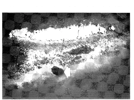
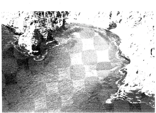
Remote s e n s i ~ g data (1988, 1989). Analysis of S ST fields from satellite imagery provided details of nearshore t empel~ it ure con&tions and variations during the SW monsoon. The grids analyzed are shown in Figure 29. The images in Plate 1 reveal a thermal front off Ra's a1 H a d d in July 1989 (a), and w;irm pools on the NW side of Masirah Island and a t Bar r a1 I-Iikman, across RIasirah Channel on the mainland coast, i n August 1988 (b).
SSTs on t h e south side of Ka's a1 Hadd were 24"-25"C, and increased to 27"-28°C around the point towards the NW (near Sur). The temperature change was more abrupt a t Masirah Island, with SSTs of 23"-24°C a t easterly exposures and 27"-28°C towards the west.
S S T ("C) GULF OF
MASIRAH 19 21 20
2 8
22
I A R A B I A N S E A
24 2 4 25 26
1
5 4 55 56 57 58 5 9 I 6 0 IFigure 27. Mean monthly SST isotherms constructed from Wansen cast data from Arabian S e a waters, southern region of Oman, July (1933-1979), SW monsoon.
The Muscat a n d Masirah Island areas are compared in Figure 30 i n tclms of seasonal upwc~lling activity and persistence of t h e w a r
respectively. Only a single, weak upwelling plume was detected off
i n 1988 (Figure 30 A), in early July, whereas large areas experienced upwelling i n 1989, most llotably in August a n d September (Figure 30 13).
Warm pools covered extensive areas along t h e west side of Masirah Island a n d a t Barr a1 Iliklnan in 1988 (Figure 30 A; Plate 1). The mean area of the warm pool in 1988 was 1,001 square nautical miles (= 1,855 km2). Warming was not as evident in 1989 (Figure 30 13); the warm pool then h a d a mean area of only '738 square nautical miles (= 1,368 krn2).
The seasonal advection of cool, upwelled waters into the SW sector of the Gulf of Oman i s i n h c a t e d i n Figure 31 for 1988 a n d 1989. I n both years, t h e onset of cooling began in late May. Coastal cooling began a s early a s June-July in 1989, but not until August in 1988. The penetration of cool,
G U L F OF O M A N
I I u
J F M A M J J A S O N D
Figure 28. Seasolla1 SST variations in the Gulf of Oinan (above) a n d Arabian S e a (below) constructed from Nailsen cast d a t a , 1933-1979. Horizontal lines denote monthly meall values, bars the 95% confidence intervals of means a n d vertical lines t h e inaxilnuin a n d ininimunl temperatures. Numbers of observations are indicated fbr each month.
A R A B I A N
S E A
Figure 29. . h e a s stucbed for SST patterns from 1958 a n d 1989 (satellite infia-red data). Location of 1" grids over the Muscat-Daymaniyat Islands (Capital) a n d Masirah Island axeas, and t h e G" grid over the Gulf of O m a n - h a b i a n Sea boundary off Ra's a1 Hadd.
upwelled water from the Arabian Sea into the Gulf of Oman was greater i n 1989 t h a n i n 1988, a n d the cool front off Ra's a1 Hadd persisted 2-3 weeks longer in 1989 t h a n in 1988. Synoptic plots illustrating the percentage occupancy of cool fronts also reveal a greater spatial penetration into the Gulf of Oman in 1989 compared with 1988 (Figure 32).
i,oco
-
M u s c a t a r e a
-
800
-
2 9 M a y - 15 S e p 1 9 8 8
600 - -
400 -
: u p w e l l i n g p l u m e
200 - , 1
.
1 I *.
. a a eM a s i r a h I s l a n d ,
-
800
-
$I I -I "L 0
400 - /'-\\ *
w o r m pool -
I I - .- 1--
Jun Jul A u g S ~ P
M u s c a f a r e a
3 0 M o y - 3 0 S e p 1 9 8 9
Figure 30. Upwelling activity in the Muscat area and persistence of a coastal warm pool along the lee side of Masirah Island during the monsoon season.
The thermal changes are expressed in terms of sea surface area per 1"
geographic quadrant for 1988 (A) and 1989
(B).
Both plots in 1988 are based on 47 days each, and in 1989 on 58 days (Muscat) and 61 days (Masirah).29 M a v - 3 Jun ( n = 4)
6 Jun - 2 5 Jul ( n = 17)
1-15 S e p ( n = IO!
r - ' - - - 7
3 0 M a y - 4 J u n ( n = 3 )
I
2 4 0 N5 Jun - 3 0 J u l ( n - 1 % )
4 A u a - 14 S e p ( n - 2 7 )
1 5 - 3 0 S e p ( n = lo!
2 3"
2 2"
159" 60" 62"
Figure 31. Devcloyment and spread of' cold fronts near Ra's a1 Hacid during the sunliner 111011~0011 periods in 1988 and 1989. Diagonal line patterns in&cat e the masiniuin penetration of cool Arabian Sea waters into the southern Gulf of Oman. Constructecl from satellite SST images with observation dates and number of days examined i n h c a t e d in each panel.
F ~ g u r e 32. I'erccntagc occupancy by area of t h e leacling ( n o r t h e ~ l y ) SST cold fronts off'12a1s a1 I-lacicl during the summel. 111011soo11 season i n 1988 and 1989.
Plotted i n 0.5" q u a d r a n t s from the niinimuni curve grid interpolation algorithm witll a maximum absolute error of 0 005 a n d 500 iterations (Surfer. Golden Software, Inc.).