Project Dissertation submitted to the Civil Engineering program of Universiti Teknologi PETRONAS in partial fulfillment of the requirement for. In order to reduce the problems, it is recommended to establish a pedestrian network in UTP to provide a more convenient environment for students to walk, making walking inside the campus more attractive than driving. Thus, one approach in achieving the university's goal is to improve the study environment in UTP by offering modern infrastructure and excellent facilities to students so that students can adapt to the environment and improve themselves.
The growth of the student population at UTP is increasing year by year, which is why the number of students who come to the university with their own vehicles is growing rapidly. Based on the circumstances, it is recommended that a walking network be established in UTP to provide a more convenient walking environment for students and thus make walking on campus more attractive. For example, the University of Oxford aggressively promotes walking as a substitute for using a car [1].
The main objective of the study is to propose a walking network in UTP that will provide better pedestrian facilities especially to the students. Pedestrian route networks should be free of gaps and connected to the main points where pedestrians start or complete their journeys.
Shared walkway and cycle trackin Japan
Sidewalk in Putrajaya
Covered walkway
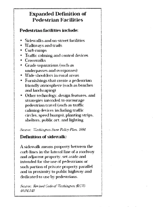
Meanwhile, the 1994 Washington State Policy Plan recognizes that "pedestrian facilities" are far more comprehensive than the simple definition of a sidewalk as defined by Washington law. People may be forced to walk in the road, leading to increased pedestrian/motor vehicle collisions. Not providing a durable and safe place to walk ignores the needs of people who rely on walking as a means of travel.
Establishing policies to ensure that safe places to walk are developed is a good starting point in making a community more walkable. Some technical information on the design of sidewalks and walkways from the Pedestrian Facilities Directive, prepared by Otak, can be referred to Appendix A. Decisions on the most appropriate type of measure are therefore usually determined by the existing characteristics of the street or area in question, but There are variants of options depending on the extent to which vehicles can or should be excluded.
Appropriate exemptions (in addition to those of emergency services, etc.) where vehicular intrusion is permanently restricted, footpaths can often be widened and in these circumstances provision must be made for vehicles to minimum standards consistent with safety. For aesthetic reasons, this should be kept to a minimum in accordance with legal requirements and driver understanding.
Pedestrian prioritized area
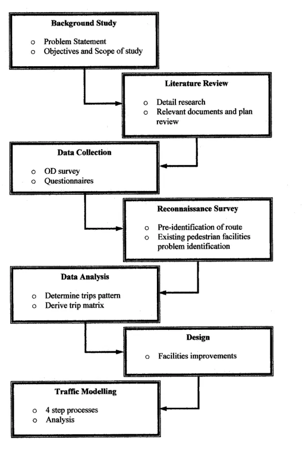
METHODOLOGY
PROCEDURE IDENTIFICATION
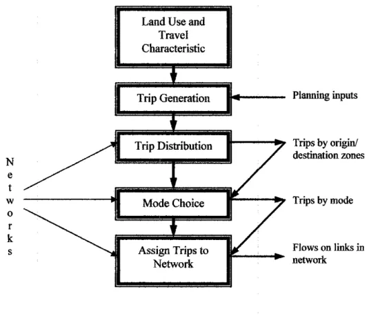
- Trip Generation and Trip Distribution
Reconnaissance is conducted to identify and assess physical features in the study area. In addition, an assessment of the walking environment in UTP and observation of existing facilities for pedestrians is also carried out. Problems with existing facilities are identified and what changes need to be made to improve the existing ones.
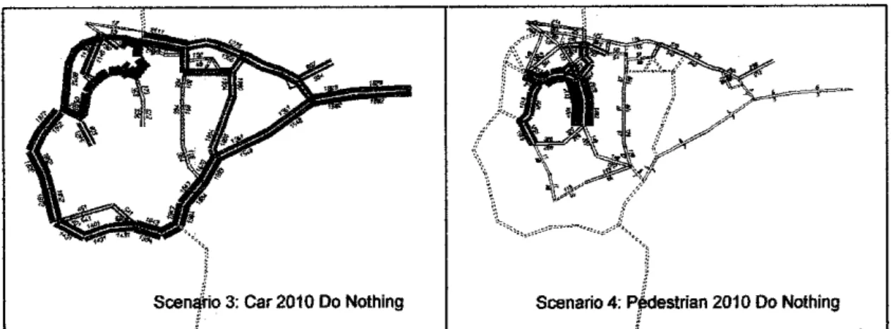
Crosswalks should be proposed at certain points to ensure pedestrian safety when crossing the street. This software package is considered the most suitable analytical tool due to its transparency, in the sense that all key functions and assumptions of the computer model are user-friendly and can be easily checked and replicated. 2010 do nothing (no changes to facilities) o UTP is assumed to be fully developed.
The total student population of UTP in the starting year 2005 is 4,400 students, and for the year 2010, by which time UTP is fully developed, it is estimated at 6,600 students. Thus, the population growth factor is 1.5, which means that the student population increases by 50% in 5 years. The first part of the questionnaire asks about students' information about travel per hour based on their typical day.
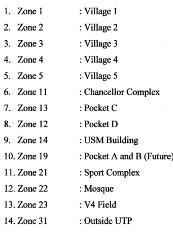
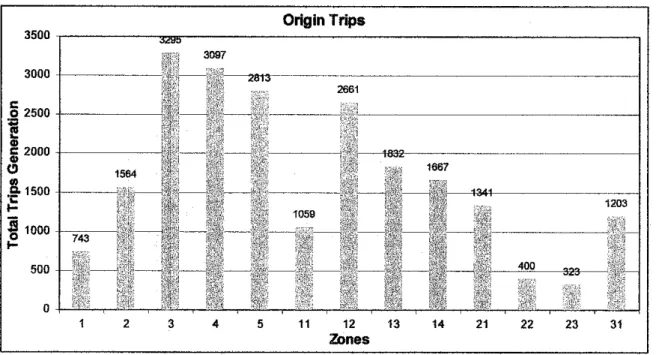
From the table, most of the trip generation was done from zone 2 and zone 5, because most of the successfully collected questionnaires were from these two zones. But the travel attraction model can be considered because from the observation made during the weekdays, most of the students went to academic buildings instead of going out. However, for the purpose of this study; Questionnaires were distributed to 20% of the student population who are from village 1, village 2, village 3, village 4 and village 5.
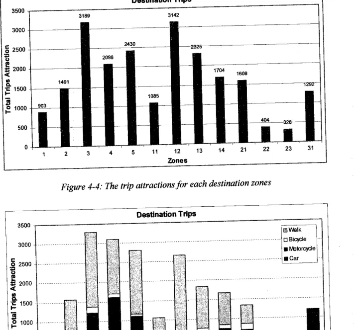
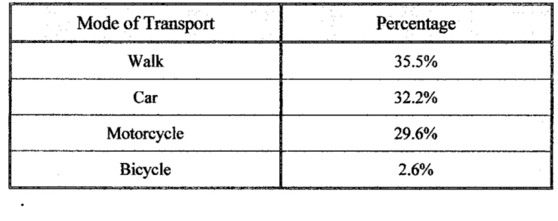
When asked which mode of transportation suits them best, most students choose walking with a motorbike, 29.6% choose driving a car and the remaining 2.6% choose riding a bicycle. 2010 do nothing (no changes to facilities) o UTP is assumed to be fully developed o Pedestrian connections are not 100% guaranteed. The increase in demand for walking in 2010 will be based on an analysis of questionnaires on how many students are willing to change their mode of transport from car, motorcycle or bicycle to walking if sufficient and improved pedestrian options are provided.
The survey shows that the total number of students who are willing to change their mode of transportation if well-designed pedestrian facilities are provided is 72.6%, while the remaining number of students who are not willing to change is 27.3%. In base year 2005, the current scenario where the pedestrian is available but does not cover the entire area, Figure 4-6 shows that on a typical day;
Improper surfacefor pedestrian near Village 3
Improper surface at the New Campus blocks
Sidewalkalong the roadfrom Village 2 to Village 4 which is notproperly provided
Discontinuity ofwalkway near Village 3
Discontinuity ofpedestrian route at theNew Campus blocks
Environmentalfactor also contributes to modal choice
Some students still prefer to walk rather than riding vehicles
The Institution of Highways and Transportation and The Department of Transport
States of America, available at. http://www.bts.gov/programs/onmibus_surveys/targeted_sun^ey/2002_national_su rvey_ofj)edestrian_and_bicyclist_attita^.
Highway Capacity Manual 2000, Transportation Research Board, National
Jalal, BSc (Hons) Eng., MSc (Transport), MIHT; Senior Transport Engineer,; Department of Roads and Highways; Jurutera Perunding Zaaba Sdn. The cities, towns, counties, and other jurisdictions within the central Puget Sound region should consult the following guidelines when planning new bicycle and pedestrian infrastructure and programs. This would ensure an integrated, seamless regional cycling and pedestrian system that meets the needs of the greatest number of people and enables the greatest possible growth of cycling and walking in the future.
Types of Bicycle and Pedestrian Facilities
In addition to the above types of linear on- and off-road transportation facilities, there is a wide variety of complementary facilities that further support effective and convenient pedestrian and bicycle travel. Choosing the type of facility to locate depends on a host of factors and considerations, including the destination to be served, existing infrastructure, right-of-way issues, and many others. This document provides summary guidance to help begin planning for the locations and general types of bicycle and pedestrian facilities that may be desired for inclusion in a community's or jurisdiction's transportation plan element.
For more specific details on siting a particular type of facility, including design and safety specifications, see The Guidefor the Development of Bicycle Facilities (AASHTO, 1999) and the Pedestrian Facilities Guidebook (Washington State Department of Transportation, 1997).
Type of Place-Geographic Classifications
They provide parking so people can drive in, park their car and transfer to the bus.
Facility Development Guidance
The area around regional transit stations is often targeted for high levels of mixed use that includes both commercial and residential. Both sides of the street within a half-mile radius (ten-minute walk) of urban centers, activity areas, regional transit stations, regional park-and-rides, major parks and other recreational destinations, as well as colleges and universities. Both sides of all streets within a quarter mile radius (five minute walk) of bus stops.
Every major intersection and/or every other blocks within a Vz mile radius of urban centers, activity areas, regional transit stations, regional park-and-rides, major parks and other recreational destinations, and colleges and universities. At every major intersection and/or every other block within a radius of 1.5 km from transit routes. At every major intersection and/or every other block within a XA mile radius of elementary, middle, and high schools.
At regional transit stations, people often leave their bikes unattended for hours, even overnight. For this reason, it is recommended that bicycle lockers be provided. It is also desirable to supply bike lockers in other high demand locations such as regionally important car parks, regional shopping centers and colleges. Facilities such as benches, water fountains, toilets and garbage receptacles should be available in sufficient quantity where there are many pedestrians and cyclists.
In addition to parks and public squares, street furniture should also be present in urban centers, areas of regional transit stations, activity areas, large park-and-rides and at bus stops. Proper lighting should be provided at every transit stop, in urban centers, at regional transit stations, park-and-rides, commercial districts, and community attractions. In streets where there is a lot of cycling and walking in urban centers, regional public transport stations and activity areas.
In the Puget Sound region, designated biking and hiking trails must be marked, making them easily recognizable. Common destinations such as tourist attractions, universities and colleges, and retail districts should also be signed to guide pedestrians and cyclists. In addition, maps depicting bicycle and pedestrian routes should be produced, regularly updated and made available to the public.
For the origin and destination, citizens near the village 1 Village 2 Village 3 Village 4 Village 5 USMN Construction Sport Complex Kanselor Complex XhepiC XhepiD. What is your most preferred mode of transport to travel to UTP. If the pedestrian facilities in the UTP are improved with well-designed facilities (eg covered walkways etc.), would you consider walking as your main mode of transport in the UTP?.