AirTransit Trip Planner Application
By
Muhamad Hafiz Mughni bin Azhar Dissertation submitted in partial fulfillment of
the requirements for the Bachelor of Technology (Hons)
(Information and Communication Technology)
JANUARY 2013
Universiti Teknologi PETRONAS Bandar Seri Iskandar,
31750 Tronoh Perak Darul Ridzuan
ii
CERTIFICATION OF APPROVAL AirTransit Trip Planner Application
By
Muhamad Hafiz Mughni bin Azhar A project dissertation submitted to the Information & Communication Programme
Universiti Teknologi PETRONAS in partial fulfillment of Bachelor of Technology (Hons)
(Information and Communication Technology)
Approved by,
___________________
(SAIPUNIDZAM BIN MAHAMAD)
UNIVERSITI TEKNOLOGI PETRONAS TRONOH, PERAK
January 2013
iii
CERTIFICATION OF ORIGINALITY
This is to certify that I am responsible for the work submitted in this project, that the original work is my own except as specified in the references and acknowledgements, and that the original work contained herein have not been undertaken or done by unspecified sources or persons.
MUHAMAD HAFIZ MUGHNI BIN AZHAR
iv
ABSTRACT
The number of flight on transit passenger in Kuala Lumpur International Airport (KLIA) had been recorded almost 35 million of people in 2010. This passenger on transit will spend their time at the airport while waiting for the next flight without any planning to visit tourism places nearby due to short period of time and much information needed to plan a short trip. This is such a waste because they actually can boost countries’ economy in the tourism sector if they spend their time to visit some tourism places nearby the airport. Because of that, AirTransit Trip Planner aims to help these passenger on transit by planning a short trip to the nearby tourism places within the transition hour they have.
AirTransit Trip Planner is using a mathematical algorithm in order to calculate and suggest how many nearby tourism places a user can visit based on their flight transition time. The algorithm also need to consider the distance of the tourism places from user’s current location and also time taken to go there. Besides the mathematical algorithm used for sorting, AirTransit Trip Planner also using Google Map API as a map to guide user and Google Places API as a data center to grab all the tourism places and its details. The output of this calculation is a suggestion of short trip planner for the user (passenger on transit). The trip planner will list down the tourism places user can visit within their flight transition hour, the distance to go there and also time taken to go there. Indirectly, this AirTransit Trip Planner application also helps to boost economy in the tourism sector of a country
v
TABLE OF CONTENT
CERTIFICATION OF APPROVAL ii
CERTIFICATION OF ORIGINALITY iii
ABSTRACT iv
TABLE OF CONTENT v
LIST OF FIGURE vii
LIST OF TABLE vii
CHAPTER 1: INTRODUCTION 1
1.1 Background of Study 1
1.2 Problem Statement 2
1.3 Objectives 2
1.4 Scope of Study 2
1.5 Relevancy and Feasibility of the Project 3
CHAPTER 2: LITERATURE REVIEW 4
2.1 What is Android smart phone and Android application. 4
2.2 Tourism Mobile Application 5
2.3 Context-Awareness Application 5
2.4 Development 6
2.5 Comparative Study 7
CHAPTER 3: METHODOLOGY 10
3.1 Research Methodology 10
3.1.1 Data Gathering : Survey and Interview 10 3.1.2 System and Software Design : Flow of the
system and Graphical User Interface (GUI) 11
3.1.3 Usability Testing. 12
3.1.4 Implementation 12
3.1.5 Submission of report 13
3.2 Project Activities 13
3.3 Tools Required 13
CHAPTER 4: RESULTS AND DISCUSSION 15
4.1 Results and Analysis of the Survey 15
4.2 System Flow 18
4.3 Mathematical Algorithm for Sorting 20
4.4 Early Draft and Final Design of the User Interfaces 21 4.5 Results and Analysis of the Usability Test 26 CHAPTER 5: CONCLUSION AND RECOMMENDATION 32
5.1 Conclusion 32
5.2 Recommendation 32
vi
REFERENCES 33
APPENDICES 34
vii
LIST OF FIGURES
Figure 3.1: Rapid Application Development (RAD) Based Method 10
Figure 4.1: Respondents’ age 15
Figure 4.2: Respondents’ occupation 16
Figure 4.3: Respondents’ yearly flight transit 17
Figure 4.4: Respondents’ percentage of having tour 17
Figure 4.5: Feedback on AirTransit Trip Planner Application 18 Figure 4.6: Flow Chart of The AirTransit Trip Planner Application Flow 19 Figure 4.7 (a). Early Design of Main Interface to Capture User Transit Hour 21 Figure 4.7 (b). Final Design of Main Interface to Capture User Transit Hour 21 Figure 4.8 (a). Early Design Interface to List All Suggested Tourism Places 22 Figure4.8 (b). Final Design Interface to List All Suggested Tourism Places 22 Figure4.9 (a). Early Design Interface to Show the Details of Tourism Place 23 Figure4.9 (b). Final Design Interface to Show the Details of Tourism Place 23
Figure 4.10: Interface of Map to Show All Locations 24
Figure 4.11: Pop Up When User Click Each Mark On the Map 24 Figure 4.12. Direction Between User Location and Destination 25 Figure 4.13. Global Positioning System (GPS) Navigation Interface 26
Figure 4.14. Respondents of Usability Test Age 27
Figure 4.15. Respondents of Usability Test Occupation 28 Figure 4.16. User Feedback On Application’s Interface Design 28 Figure 4.17. Respondents’ Feedback on Reliability of the Application 29 Figure 4.18. Respondent’s Answer When Being Asked to use the Application 30 in Future
LIST OF TABLES
Table 2.1: Comparison of Other Tourism Application Avalaible With AirTransit
Trip Planner 8
viii
ABBREVIATIONS AND NOMENCLATURES
API Application Programming Interface
App Application
GUI Graphical User Interface
KLIA Kuala Lumpur International Airport RAD Rapid Application Development SDK System Development Kit
OS Operating System
1
CHAPTER 1 INTRODUCTION
1.1 Background of Study
In this emerging world, daily tasks require us to go to few far places for tasks’
completion. With the aid of evolving transportation nowadays, it makes the travel process becomes easier for the society to reach their desired destination. The most accommodating transportation to reach far places in shortest time would be the airlines.
However, far distance of destination has led to a flight transit at some airports in which the better proposed solution suggest, to make a halt. On the other thought, people on transit sometime ended to have to spend almost half of the day at the airport doing nothing. They are unable to travel around the nearby places as they do not know the information of the location. Thus, AirTransit Trip Planner application is implemented to assist people on transit to make decision.
AirTransit Trip Planner application is a mobile application build on Android platform.
Mobile application which also known as mobile app is software that runs on Smartphones or mobile phones. The world of mobile apps is evolving at a blistering pace [1]. Few would have predicted the phenomena of mobile apps explosion since 3 to 4 years ago.
Mobile application platform varies according to different type of mobile’s operating systems such as iOS (Apple), Windows, Symbian, Android and many more. However, compared to the other operating system, Android has been used widely worldwide because it is an open source platform and it allows the developers to change the codes according to people preference. It is easy to handle, easy to implement.Besides, Android is the most compatible mobile development platform.
2 1.2 Problem Statement
The gap between arrival and next flight if someone undergoes flight transit are commonly around 4 hours to 12 hours. Some even did take more than 12 hours. Most of the time, travelers missed out to plan what they should do at the transit-airport, before arriving at their final destination. Due to the plenty of time, flight passengers feel bored and do not know where and how to get around the place while waiting for their next flight. A one- time question asking to information center might be anticipated, but there is nobody to guide them every minute to where they are heading and too much question need to be asked if they want to plan a short trip. For that reason, an application need to be created specifically to cater the needs for exploring the new place independently and the application also need to be intelligent where it can detect user location and suggest some tourism places nearby to be vested within the flight transition hour. .
However, the root cause found to this problem is there is minimum or no proper channel for information gathering regarding the nearby tourism places and due to the short period of time passenger on transit cannot plan their short trip well thus they decided to stay at the airport.
1.3 Objective of the Project
The objective of this project is to develop an Android Mobile Application which enabled to plan a short trip for passenger on flight transit.
1.4 Scope of Study
The scope of the study will be on creating the mathematical algorithm which actually can help to calculate how many tourism places can be visited by flight passenger on transit within the transit period they have. Besides, the calculation also should be able to come out with time duration to visit at each tourism places. In the other hand, the study also will be focusing on the best method to calculate the distance. Since this report had been
3
prepared, the best method to calculate distance is by using Google Maps API which is using Metric (kilometer), and yet this method still need to be finalized in order to find its efficiency. In the term of coding for development will be using Android Programming Language, which is enhanced from the Java Programming Language and it should be no problem to do the coding since Java is in the category of high level programming language. This application also will be developed based on Kuala Lumpur International Airport first before expanded to be used worldwide. The tourism places also will be set around 40km radius of the airport. Overall, the outcome from this study will be implemented in the application development and the result from the application testing will be evaluate and validate.
1.5 Relevancy and feasibility of the project
AirTransit Trip Planner application have no doubt will be useful to the flight passenger on transit. This is because flight passenger on transit sometime feel bored at the airport, and with this application it will help them to plan a short trip to nearby tourism places nearby. From the previous research had been done, most of the flight on transit stay at the airport because they cannot plan a short trip within their transit period well, thus with this application it will solve this problem.
This project will be divided into two phase. The first phase will be focusing more on data gathering, literature review, technical learning and research. This phase will be completed in 11 weeks. The second phase will be focusing on the development, testing, implementation and final documentation. The second phase is estimated to be completed in 14 weeks. Hence, the total of project duration is 25 weeks and this should be enough to complete this project.
4
CHAPTER 2
LITERATURE REVIEW
2.1 Android Smart Phone and Android application
Since Steve Jobs and Apple had launched iPhone in June 29, 2007, the current trend of handheld mobile devices had changed drastically. iPhone being categorized as smart phone, which means a phone with operating system and have capability of advanced computing and connectivity. But iPhone spark a new advancement in Smartphone industry when Google and Open Handset Alliance had publicly launch Android platform in 2007.The Google-inspired OS known as Android, which is open-source, which mean any vendor or third party can use Android as an OS for its devices [2]. Nowadays, the number of android smart phone user is much higher compare to iPhone due to it provides more free applications and also user can buy it with much lower price. Only in China, Tao Zhou stated that the number of Android smart phone user had reach 277 million and this proved that Android smart phone has high demand in the market [3].
The Android platform consist of handheld mobile phone software stack including an operating system, middleware, key application and it also an open source operating system. Come with android operating system is the Android Market or Google Play.
Google Play is a website which user can download application to their smart phone. What is exactly android smart phone application? Android smart phone application is an application being developed by any third party and they are allowed to use System Development Kit (SDK) and all the libraries [4]. Google actually had design Android OS to be easy and reuse thus more people can developed app by using Android Platform.
Because of this open source OS, Android had surpass iPhone in the mobile application market.
5 2.2 Tourism Mobile Application
Smart phone had brought a new culture to the world, and tourism sector also used this latest technology in order to boost economy in the tourism sector. Before this, people who are travelling depending on maps or brochure which they can get at the tourism booth in the air port. But nowadays, people with smart phone only used Google Maps on their devices and not relying more on paper map. Luciana Bordoni wrote with the advanced technologies of computer science and propose the outline of a technological infrastructure to promote, develop, and exploit cultural tourism of the country [5]. It is true that with the technology, is actually help people to travel more because they can easily find information and guide. Here in Malaysia, Ministry of Tourism had invested in smart phone application such as Go2HomeStay and also TrulyAsia.Tv [6]. Ministry of Tourism Malaysia also provides funding for people who are interested to develop smart phone application, and this clearly showed that the government also realized the effectiveness of smart phone application to boost tourism sector.
2.3 Context-Awareness Application
In the past few years, the advancement of the mobile application had lead to the development of context awareness mobile applications. Context-aware is an applications because they are sensitive to a user’s context. Same goes to the mobile tourism application, the application can be describe as a context-awareness application because they are designed to be aware of the tourist’s location and interests [7]. Actually, there are so many value which a user can get by this context-aware tourism application but there are also some challenges in the context-aware mobile application and all this will be discuss more in the next paragraph.
Actually, the tourism application is aim to help user to plan their trip faster and reduces the human effort. By using the application, a user will automatically exchange or get knowledge from the server. The knowledge is actually the information which the user need such as where are the tourism places they should visit and the distance of the tourism places from their current location. Christos Tatsiopoulos and Basilis Boutsinas stated in the knowledge exchange is being called Ontology-based knowledge
6
engineering. From this journal also the definition of Ontology-based knowledge engineering is designing, developing, maintaining and sharing ontologies, is an emerging knowledge engineering process [8]. It allows the information organization into taxonomies of concepts, represented by attributes, and relationships between concepts.
Thus, it is clearly shown that tourism mobile application is actually give value to the user in the context of knowledge and help the user to get information in short period of time.
Moreover, context-aware mobile tourism application also perceived ease of use and perceived usefulness to the user. This is the main factor why user wanted to use context aware tourism application. In order for the application to do decision making, the user interface of the application itself need to be easy to use and the output must be very useful (accurate, reliable, responsiveness, assurance and empathy to the user [9].For the user, when they gain the value when they find out this context-aware mobile tourism application is easy to us it will automatically provide trust, which mean the user trust the application and they will use it again and again. Trust reflects a user’s positive expectations of mobile service providers’ future behaviour. Trust often includes three beliefs: ability, integrity and benevolence. In a simple word, Tao Zhou trying to said that the application must be able to cater user enquiries, provide enough information to the user and also the application providers are concerned with users’ interests rather than themselves. If mobile sites are difficult to use, users will associate them with low utility.
In addition trust will affect perceived usefulness. Trust enables users to believe that mobile service providers have enough ability and integrity to provide expected utility to them. Thus, trust provides a guarantee that users will acquire positive outcomes in the future.
2.4 Developments ( Eclipse IDE, Google Map API and Google Places API)
The main platform used to develop this application will be Eclipse IDE. Eclipse IDE is a programming software for Java. It also an open source software which allow user to add plug in of other project development tool such as Android. Besides, Eclipse IDE also help novice programmer and expert to develop complex user interface easier, and it also allow user to install plug in to create more advance user interface [10]. By utilizing all
7
functions of Eclipse IDE and also install Android System Development Kit (SDK), this platform will be the perfect platform to develop this application.
Besides Eclipse IDE, the main tool needed in developing this application is Google Map API and also Google Places API. Google API is a programming interface developed by Google, and Google allow programmer to use their programming interface for free [11].
Google products which are Map and Places will be used in order to get user current location, tourism places and also pinned all the location on the map. By using Google API, this application will be easier to develop because all the database will be gathered from the Google API.
The technology on maps on these day become more advanced day by day, and most of the user depend on online map. For Android Users, Google Map will be the most suitable map since Android Operating System also developed by Google . Hence by using Google Map API and allow user to use Google Map, this will put this application on the current trend and probably will help people to easily locate tourism places nearby.
2.5 Comparative Study
Based on the research had been done, there are three Tourism Android Application available on Google Play which could be almost the same with AirTransit Trip Planner.
The application are TripPlanner, Europe Trip Planner and Kuala Lumpur City Guide.
Although these application might have some similarities with AirTransit Trip Planner, but still it do not plan a trip for a certain user’s free hour just like AirTransit Trip Planner.
Table 2.1 below show the comparison had been made.
8
TABLE 2.1. Comparison of other tourism application avalaible with AirTransit Trip Planner
Elements/App lication
Trip Planner Europe Travel Guide Kuala Lumpur Guide
AirTransit Trip Planner
User Interface Good. But not interactive.
Just Nice. It is interactive but do not have any picture of tourism places.
Good. Have maps, and also picture of tourism places
Good. Will have map with user current location on it.
Ease Of Use Not easy to use because mostly it in Japanese Language. N
Easy to use Easy to use Very easy to use.
Human Computer Interaction
User need to type if they wanted to search the tourism places they going to visit. No context-aware concept applied.
User need to choose the country they wanted to visit and all
information will be provided.
No context-aware applied.
The information will be provided only on Kuala Lumpur, user just open the app and read it.
Context-aware applied only for using GPS to guide to desire places.
User just need to choose how many free hour they have based on their flight transit hour. Then the application will suggest tourism places they can visit within the time they have.
Context-aware concept mostly applied.
Information Content
Less information on worldwide, but its provide more content on Japan.
Good. Provide more information.
Good. Provide more accurate, precise and reliable information.
Good. Provide more accurate, prcise and reliable information. It also provide the distance of the tourism place from user current location.
Plan Tourist For A Trip
No. Just provide basic information.
No. Just provide basic information.
No. Just provide basic
information.
Yes.
Main Feature/
Functionality
Provide information user wanted based on keyword user entered.
Provide information on country basis
Provide all information of tourism places in Kuala Lumpur.
Plan a short trip for flight transit passenger based on their free time.
9 Working
Offline/Online
Online Online Offline/Online Online
Target User Tourist/Travller/Backp acker
Tourist/Travller/B ackpacker
Tourist/Travller/
Backpacker
Flight transit passengers
10
CHAPTER 3 METHODOLOGY
3.1 Research Methodology
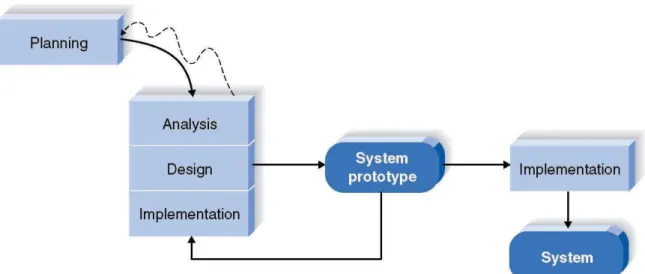
This project will be developed according to Rapid Application Development (RAD) based methodology (refer figure 3.1 below). This methodology had been choose because it rely on rapid prototyping and allow developer to test the prototype rapidly. Then after testing the developer also can redo all the coding to the prototype if needed. This RAD method also cheap and create multiple iterations of rapid prototyping models. This model is the most suitable usage due to the time frame and the nature of the project.
FIGURE 3.1. Rapid Application Development (RAD) Method
3.1.1 Data Gathering : Survey and Interview
The data gathering process will be done by questionnaire survey (see appendix 2). The propose of this survey is to know user experiences and the possible activities that the user would like to carry out during the flight transit period. The survey will be conducted to
11
the targeted user who usually use airplane to travel or attend any official matters abroad.
In the questionnaire also, there will be a section which suggest to the user about AirTransit Trip Planner and the user need to give their responds regarding the idea of developing AirTransit Trip Planner application. The survey will be conducted into two phase, the first phase will be conducted to professional workers such as lecturers, doctors, corporate employees and etc. This profesional workers had been choose because they actually travel a lot by using air plane to attend seminar, workshop, meeting or conferences in the overseas. While the second phase will be conducted at the airport, and the respondent will be the actual flight passengers who are having their flight transit period. By having the result from this survey, further analysis can be done regarding significance of the project to the targeted user and also concrete data can be gain to fulfill the system requirements.
Next, the data gathering process also will be done by constructed interview with the Ministry of Tourism Department. The propose of this interview is actually to know about the acceptance of the Ministry of Tourism Department regarding this AirTransit Trip Planner application which actually can help to promote tourism. Besides, more data requirement can be gathered from ministry perspective such as which tourism places should be AirTransit Trip Planner suggest to the user. Probably the ministry want to increase cultural tourism sector or suggesting any popular tourism places. By having this interview, a solid list of tourism places can be gathered and ready to be used to be implemented in the application development.
3.1.2 System Development and Software Design : Flow of the system and Graphical User Interface (GUI)
The system aims to be user friendly and provide ease of use to the user. Moreover the system also will be develop based on content-aware concept which enabled it to automatically detect user current location and suggest a list of possible tourism places which user can visit within their flight transition hour. The flow of the application starts with auto detection of user location when user launches the apps using their Android
12
Mobile Phone. After that, the user needs to key in their transit hour and click button OK.
Then, the system will calculate all possible variables (time and distance) and suggest how many tourism places the passenger can visit during their transit hour. Figure 4.6 in Chapter 4 for the first draft of the AirTransit Trip Planner application flow.
Coding for this AirTransit Apllication will be done by using ECLPISE IDE software. The programming language will be used is Android Programming Language which is actually the enhancement from Java Programming language. The coding algorithm will focusing more on the main output and the flow of the coding will also based from Figure 4.6 in chapter 4. The AirTransit Trip Planner application probably will have only five main graphical user interface (GUI). The user interface will be discussed in details in Chapter 4.
3.1.3 Usability Testing
The usability testing will be conducted by simulating the situation of flight transit passenger who are having their flight transit period at the airport. Several volunteers will be selected and the simulation will be done at Penang International Airport. First of all, these volunteers will be divided into three group of two or three people. Each respondent will be provided AirTransit Trip Planner application in order to help them plan their short trip. After that, all respondents will go to the suggested places listed by the application and need to get back to the airport to catch their next flight. At the end of the test, the respondents need to answer the questionnaire regarding this application. By having this test, the objective of the AirTransit Trip Planner can be clearly observe whether it meets the objective or not. Moreover, user also can give feedback regarding the application whether it meets their requirement or not. By having this data, further improvement can be done to the application.
3.1.4 Implementation
After done some further improvement, the AirTransit Trip Planner application will be uploaded to Google Play for user to download it. The implementation here means, the application is ready to be download by the user and use it in the real situation to help user
13
plan their short trip. In order to encourage more people who are having their transit period at the airport to download it, the help from Tourism Malaysia is needed. Banner, brochure or pamphlet can be provided to the people who are having their transit period from Tourism Malaysia booth at the airport.
3.1.5 Submission of report
When all the previous phase had successfully done, it is time to prepare the documentation for the AirTransit Trip Planner. The documentation will be the final report which consist of Abstract, Introduction, Literature Review, Methodology, Result and Discussion, Conclusion and Appendix. Besides that, technical report also need to be prepared based from the final report which had been done. By submitting these two reports, this project will be officially ended.
3.2 Project Activities
This project will be done in two phases, the first phases is for data gathering and research which consist of 11 weeks period. The second phase will be the application development which consist of 14 weeks period. Hence, the total number of weeks required for the project to be completed is 25 weeks. See appendix 1 for the grant chart and mile stone of this project.
3.3 Tools Required
Tools required is divided into two aspects which are the tools for research and tools for application development.
3.3.1 Research i. Internet ii. Laptop iii. Printer iv. Google Docs
v. Journal / Emerald Insight vi. Google Play
3.3.2 Application Development i. Eclipse IDE
14 ii. Java Development Kit
iii. Android SDK
iv. Android Device Manager v. DroidDraw
vi. Adobe Photoshop vii. Google Maps API viii. Google Places API
ix. Android Devices (tablet / mobile phone)
15
CHAPTER 4
RESULTS AND DISCUSSION
4.1 Results and Analysis of the Survey
A survey had been conducted (appendix 2) to the targeted user in Universiti Teknologi PETRONAS (UTP) and also in Kuala Lumpur International Airport (KLIA). The questionnaire is structured (refer appendix) and the demographic data also being captured in order to see the pattern of respondents’ answer. Below are the results and the analysis of this survey.
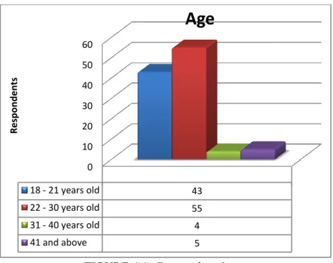
FIGURE 4.1. Respondents’ age
The survey questions have been answered by 107 respondents. The respondents are divided to few range of age which are 18 – 21 years old, 22 – 30 years old, 31 – 40 years old, and 40 years old and above. Figure 4.1 shows that people age 18 – 21 years
0 10 20 30 40 50 60
18 - 21 years old 43
22 - 30 years old 55
31 - 40 years old 4
41 and above 5
Respondents
Age
16
old and 22 – 30 years old has the highest number, which both bring 91% of the total respondents. Respondents aged 31- 40 and 41 above contents of 4% and 5%
respectively. This demographic data is important to better understand the preferences of respondents in below question which relate to how they would like to spend their time during the transit.
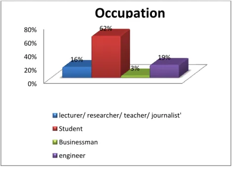
FIGURE 4.2. Respondents’ occupation
Respondents has also been identified by their occupation. Refer figure 4.2 above, 16% of respondents are lecturers, researchers, teachers and journalist. The highest number of respondents belong to students, which is 62%. The rest, 3% are businessman and 19% were answered by engineers. Relevancy underlying this demographic statistics is it also tell the reason of their preferences during how they want to spend the time. One of the concrete sample that is captured is people travelling due to business purposes prefer to stay in the airport or rest. For the purpose of this analysis, respondents who have never experience flight transit are excluded.
0%
20%
40%
60%
80%
16%
62%
3%
19%
lecturer/ researcher/ teacher/ journalist' Student
Businessman engineer
Occupation
17
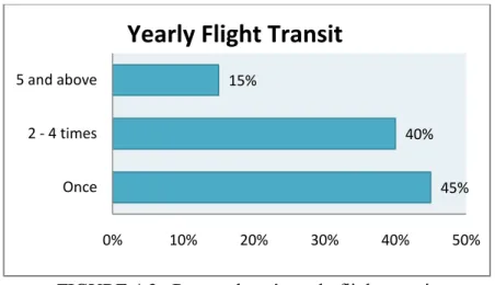
FIGURE 4.3. Respondents’ yearly flight transit
Another question being asked to the respondents is regarding their frequency of having flight transit in a year. Based on figure 4.3 above, it is found that 40% of them experiences around 2 – 4 times flight transit in a year. 45% tell us that they experience it once a year, 15% says they travel and have to undergo flight transit for more than 5 times.
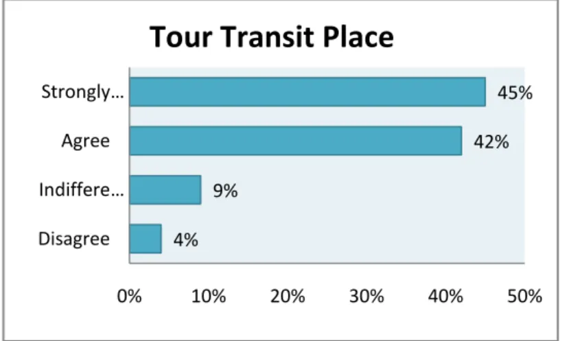
FIGURE 4.4. Respondents’ percentage of having tour
Diagram 4.4 shows that 45% of the respondents strongly agree to tour around nearby transit-airport place (outside airport). 42% of them stated that they agree to this.
Overall, this contributes 87% which say if they are on transit, they prefer to travel and explore around their reachable places. The other 9% say they are indifferent to take
45%
40%
15%
Once 2 - 4 times 5 and above
0% 10% 20% 30% 40% 50%
Yearly Flight Transit
4%
9%
42%
45%
Disagree Indiffere…
Agree Strongly …
0% 10% 20% 30% 40% 50%
Tour Transit Place
18
tour. 4% of the respondents mention that they disagree. However, the results might not be very appropriate as the gap of their flight during transit is not being asked in this survey.
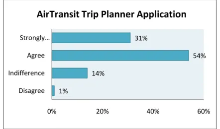
FIGURE 4.5. Feedback on AirTransit Trip Planner Application
The last question asked in the survey interpreted 54% of the respondents (referring figure 4.5) agrees to have the location directory assistance application for a tour within their time frame. 31% of the respondents strongly agreed with the suggestion. Meanwhile 14%
of them are indifference in this application suggestion. On the whole, it shows only 1% of the respondents disagree with the suggestion of implementing the application. From the result, it is applicable to implement AirTransit Trip Planner Application as it is strongly supported by total of 85% of total sample.
4.2 System Flow
The system flow of this application aims to minimize the user input. Figure 4.6 below is the flow chart of the system flow.
1%
14%
54%
31%
Disagree Indifference Agree Strongly …
0% 20% 40% 60%
AirTransit Trip Planner Application
19
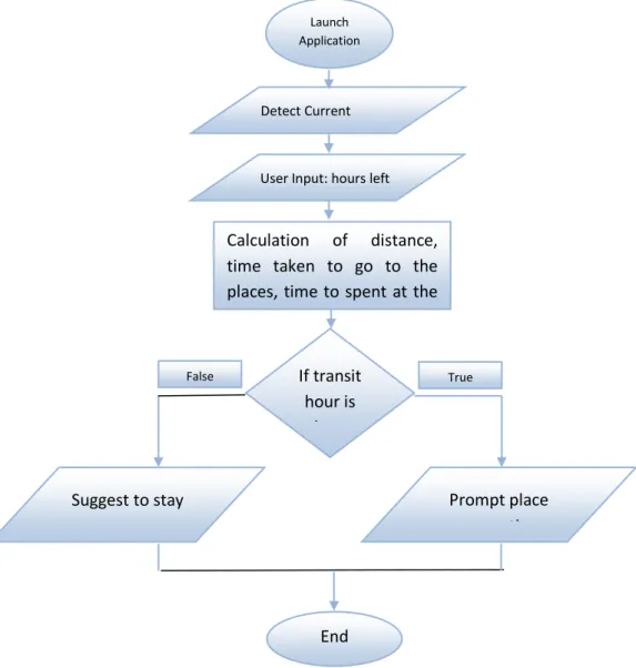
FIGURE 4.6. Flow Chart of The AirTransit Trip Planner Application Flow
Based on figure 4.6 above, when the user launch the application it will automatically detect user current location by using GPS or Google Map Location. After that user need to key in their transit hour, arriving time and also departure time.
Then, the system will use user’s transit hour to calculate how many nearby tourism places the user can visit within the transit hour he/she has. The nearby tourism places will be around 40km radius from user’s current location. If the transit hour is long enough, the system will prompt the suggested tourism places to the user else it will suggest the user just to stay at the airport.
True False
Launch Application
Detect Current Location
User Input: hours left
Calculation of distance, time taken to go to the places, time to spent at the places and time taken to go back to airport.
Prompt place suggestion If transit
hour is long enough Suggest to stay
End
20
The calculation for sorting how many tourism places a user can visit will be used a mathematical algorithm which will be explain on the next sub topic in this chapter.
4.3 Mathematical Algorithm for Sorting
In order to suggest how many nearby tourism places users can visit within their transit hour, a mathematical algorithm had been developed to solve this problem. This algorithm will be using user’s transit hour, duration to go to the destination, time to spend at each places, and one hour reserved to get back to the airport. In the algorithm, 60 minutes will be allocated to spend at each tourism places and last 60 minutes will be reserved for the user to go back to the aiport.
Let say the user input is 4 hour and in the Google Place database there are three places, Place A, Place B and Place C. The duration to go to these places will be 30 minutes, 15 minutes and 10 minutes respectively. The duration to get to Place A is calculated from the user current location which is the airport, and duration to get to Place B will be calculated from Place A and Place C will be calculated from Place C. The calculation will start by converting 4 hour into minutes.
4 * 60 = 240 minutes.
Then, this 240 minutes will minus the duration to go to places A and the time to spend there.
240 – 30 – 60 = 150 minutes.
Since 150 minutes is greater than the 60 minutes reserved time, hence the system will suggest Place A to the user. Then it will proceed the calculation for Place B.
150 – 15 – 60 = 75 minutes.
Since 75 minutes is greater than the 60 minutes reserved time, hence the system will suggest Place B to the user. Then it will proceed the calculation for Place C.
75 – 10 – 60 = 5 minutes.
21
5 minutes is lower than 60 minutes reserved time, hence the system will not suggest Place C.
So, in the User Interface only two tourism places will be suggested to the user based on this scenario. And this user also have 75 extra minutes to get back to the airport to catch his/her next flight.
4.4 Early Design and Finalized Design of User Interface of Air Transit Trip Planner Application
AirTransit Trip Planner Application will have five main user interfaces, plus the other one interface is the pre-installed navigation apps developed by Google. In the early design, the interface being developed for only three features which are to list all of the tourism places, the details of the places and to locate each places on the map. But during the real development, and after realizing the important of new features, more interface design were being developed in order to add features to list all of the tourism , locate each places on the map, the details of the application, draw direction on the map based on transportation mode and also GPS navigation. The early and finalized interfaces design are as follows:
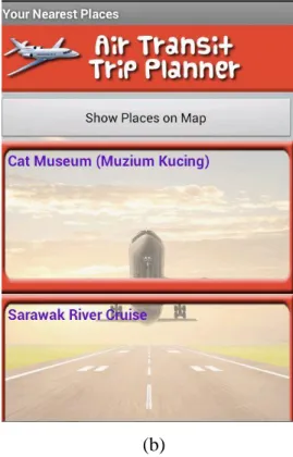
(a) (b)
22
FIGURE 4.7 (a). Early Design of Main Interface to Capture User Transit Hour FIGURE 4.7 (b). Final Design of Main Interface to Capture User Transit Hour
Figure 4.7 above is the first interface user will see when they launch the application. In the background when this interface prompt, the system actually will automatically detect user current location by using GPS or Google Places. If no internet access or GPS is turn off, the system will prompt a pop up asking the user to turn on GPS or connect to internet. But if everything is fine, user just need to key in their transit hour and departure time then click enter.
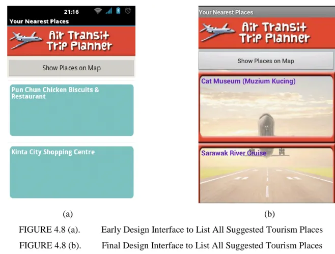
(a) (b)
FIGURE 4.8 (a). Early Design Interface to List All Suggested Tourism Places FIGURE 4.8 (b). Final Design Interface to List All Suggested Tourism Places After that, the system will calculate how many tourism places the user can visit within the transit hour they have by using the algorithm. Then, the system will direct to new user interface with scrollable list view (figure 4.8). In this interface, user can scroll to see how
23
many places they can visit. Each places on the list view is actually a button. When the user press each places it will prompt a new interface with the details of the location (figure 4.9). On top of this interface also it have a button to display all map. When the user press this button a pop up will appear to display map with user location and all tourism places location pinned on the map (figure 4.10).
(a) (b)
FIGURE 4.9 (a). Early Design Interface to Show the Details of Tourism Place FIGURE 4.9 (b). Final Design Interface to Show the Details of Tourism Place
24
FIGURE 4.10. Early and Final Design Interface of Map to Show All Locations, Red Mark is User’s Location and Blue Mark is Tourism Places Location
FIGURE 4.11. Early and Final Design Interface of Pop Up When User Click Each Mark On the Map
25
In figure 4.11 above, this is the pop up interface when user click each mark on map.
When the user click the mark, the pop up will show the address of each location.
In the next following interfaces, it is the new interfaces being added to the application. In the early design, these interfaces being considered to be developed in future. But by realizing the important of it, then it is must be implemented earlier than expected.
FIGUR 4.12. Direction Between User Location and Destination
This interface is a Google Navigation interface which being called via code by AirTransit Trip Planner application. This interface showed the direction between user location and the tourism places they wanted to visit. By calling this Google Navigation interface, it allows user to choose the transportation mode and the direction will be draw based on the transportation mode choose by the user.
26
FIGURE 4.13. Global Positioning System (GPS) Navigation Interface
Figure 4.13 will be open when user click the navigation button from the Direction Interface (Figure 4.12). This navigation interface is using satellite and it is implementing context awareness concept where it will direct user to their destination. This interface also have voice navigation which will help the user to hear the navigation while driving rather than looking at the map continuously.
4.5 Results and Analysis of the Usability Test
A usability test of AirTransit Trip Planner Application had been conducted in Universiti Teknologi PETRONAS and also in Penang International Airport. The aim of this test is to collect data on users’ feedback regarding functionality of the application and the usefulness (user interface) of the application. Based from the data, a conclusion can be made whether this application is reliable enough for users to use in order to plan their short trip.
In order to conduct this survey, the application had being installed in each respondents’
mobile devices. Then they are given only 4 hour time to plan their short trip by using the
27
application. After that, each respondents need to have a visit to each tourism places listed by the application. At the end of the visit, the respondent will answer a structured questionnaire ( see appendix 3). The demographic data of the respondents also being captured in order to know the pattern of users’ answer.
FIGURE 4.14. Respondents of Usability Test Age
The survey questions have been answered by 15 selected respondents. The respondent being selected based on their time constraint because we do not want to disturb the respondents’ precious time. The respondents are divided to few range of age which are 18 – 21 years old, 22 – 30 years old, 31 – 40 years old, and 40 years old and above. Figure 4. shows that people age 22 - 30 years old and 31 – 40 years old has the highest number, which both bring 80% of the total respondents. Respondents aged 18-21 and 41 above contents of 16.6% and 8.3% respectively. This demographic data is important to better understand the preferences of respondents in the questionnaire which relate to how their feeling and experiences while using the application.
0 2 4 6 8 10
Age
Age
18 - 21 22 - 30 31 - 40 41 and above
28
FIGURE 4.15. Respondents of Usability Test Occupation
Respondents has also been identified based on their occupation. Refer figure 4.15 above, 36% of respondents are lecturers, researchers, teachers and journalist. The highest number of respondents belong to businessman, which is 40%. The rest, 4%
are others (labour, engineer and etc) and 20% were answered by students. Relevancy underlying this demographic statistics is it also tell the reason of their feedback regarding the usbality of the application.
FIGURE 4.16. User Feedback On Application’s Interface Design
20 3640
4
Occupation (in percentage)
Student Lecturer / Teacher / Journalist / Resercher Businessman Others
0% 10% 20% 30% 40% 50% 60% 70% 80% 90%
Interface Design
Very Difficult to use Difficult to use Just Nice Good Very User Friendly
29
One section of the question being asked in the question is to know the ease of use of the application interface. The interface being design as simple as possible yet attractive in order to make this application user friendly and easy to use by all level of ages. Based on figure 4.16 above, 80% of the respondents said that the interface is really easy to use and it is a user friendly interface. Meanwhile 15% of the respondents said the interface is good and the other 5% of the respondents said the interface is just nice. On the other hand, there was no respondents said that the interface is really hard to understand and really difficult to use. Based from this data, a concrete conclusion can be made, it is proved that AirTransit Trip Planner interface is user friendly and easy to use.
FIGURE 4.17. Respondents’ Feedback on Effectiveness of the Application
In the questionaire, one question being asked in order to captured users’ feedback on the reliability of the application. Based on figure 4.17 above, 78% of the respondents said the application is very reliable and it helped them to plan their short trip well.
Moreover, 15% of the respondents said that the application is reliable and it just meet
0% 10% 20% 30% 40% 50% 60% 70% 80% 90%
Effectiveness of the Application
Not Effective Need More Improvement Just Nice Effective Very Effective
30
their expectation. 1% of the respondents said it just nice, and the other 6% of the repondents said the application need more improvement. Although there were 6% of the respondents said this application need more improvement, but there was no respondents said that this application is not reliable. Hence, the conclusion can be made here is the application is reliable and further improvement can be made in order to enhance it to become more practical to be used in future.
FIGURE 4.18. Respondent’s Answer When Being Asked to use the Application in Future
The last question being asked in the questionaire was aimed to captured respondents feedback whether they would like to use AirTransit Trip Planner Application as their trip planner in future. By referring figure 4.18 above,we can see there were 83% of the respondents said they definitely would like to use this application as their trip planner in the future. While, 8% of the respondents just said yes and they would like to use this application in future. Moreover 6% of the respondents are in between whether to use it or probably not depend on the situation. The other 3% said they
0% 10% 20% 30% 40% 50% 60% 70% 80% 90%
Would you use this application as your trip planner?
No Probably In between Yes Definitely
31
probably will not use it. Eventhough there are 3% of the respondents probably will not use this application in future, but by having 88% of the respondents said they would use this application it means that the respondents are satisfied and this application had meet the main objective which is to help passengers on transit to plan their short trip within the transition hour they have.
32
CHAPTER 5
CONCLUSION AND RECOMMENDATION
5.1 Conclusion
The AirTransit Trip Planner Application intended to help flight passenger who are on flight transit period to plan short trip to the nearby tourism places within the time limit they have. It is proved that with the algorithm implemented to sort the data gathered from Google Places API, it can helps passenger on flight transit to plan their short trip. By fully utilizing Google Map API and also Google Places API, it had make this application smaller in size and also fast to detect user current location. Besides, it also can direct user to see the nearby tourism places on the map. Overall, this application is simple to use and it also very effective for any kind of people who travel by using air plane.
5.2 Recommendation
There are still some improvement and features can be added to AirTransit Trip Planner application in future in order to make it more reliable and effective to plan short trip for passenger on air transit. Also by having data collected from usability test, there are some recommendation being made by the respondents in order to improve the quality of the application. The improvement, recommendation and new feature can be added in future are as follows:
i. Alarm Reminder ii. Saved button
iii. Picture of the tourism places
33
REFERENCES
[1] Schwinger, W., Grün, C., Pröll, B., Retschitzegger, W., & Schauerhuber, A.
(2005). Context-awareness in mobile tourism guides–A comprehensive survey.Rapport Technique. Johannes Kepler University Linz.
[2] Grøtnes, E. (2009). Standardization as open innovation: two cases from the mobile industry. Information Technology & People, 22(4), 367-381.
[3] Grøtnes, E. (2009). Standardization as open innovation: two cases from the mobile industry. Information Technology & People, 22(4), 367-381.
[4] Curwen, P. (2010). Is your smartphone smarter than mine?. info, 12(2)
[5] Bordoni, L. (2011). Technologies to support cultural tourism for Latin Latium.Journal of Hospitality and Tourism Technology, 2(2), 96-104.
[6] Ministry of Tourism Malaysia [Online]. Available:
http://motour.gov.my/en/mobile/smartphone.html
[7] Tan, E. M. Y., Foo, S., Goh, D. H. L., & Theng, Y. L. (2009, November).
TILES:classifying contextual information for mobile tourism applications.
In Aslib Proceedings (Vol. 61, No. 6, pp. 565-586). Emerald Group Publishing Limited.
[8] Tatsiopoulos, C., & Boutsinas, B. (2010). Automatic knowledge exchanging between tourists via mobile devices. Journal of Hospitality and Tourism Technology, 1(2), 163-173.
[9] Zhou, T. (2011). Examining the critical success factors of mobile website adoption. Online Information Review, 35(4), 636-652.
[10] [10] Murphy, G. C., Kersten, M., & Findlater, L. (2006). How are Java software developers using the Elipse IDE?. Software, IEEE, 23(4), 76-83.
[11] van Hage, W., Katrenko, S., & Schreiber, G. (2005). A method to combine
linguistic ontology-mapping techniques. The Semantic Web–ISWC 2005, 732-744.
34
APPENDICES
29 APPENDIX 1 : Grant Chart
No. Details/Weeks 1 2 3 4 5 6 7 8 9 10 11 12 13 14 15 16 17 18 19 20 21 22 23 24 25 26 27 28 Planning Phase
1. Research on Preceding Studies 2. Identify Problem
and Propose Solution 3. Clarify Scope,
Goal and Objective 4. Identify
Milestone and Grant Chart 5. Submission of
Extended Proporsal Analysis Phase 6. Prepare System
Requirement 7. Conduct survey 8. Analyze System
Requirement 9. Analyses user
needs from survey 10. Developed
system flow
11. Proposal Defense Design Phase
30 12. Design the User
Interface 13. Start coding to
Implement Google Map API 14. Start coding to
Implement Google Places API 15. Coding to get
user input 16. Implement
mathematical algorithm for sorting the result 17. Implement
screen capture function
Implementation Phase
18. Usability Testing 19. Functionality
Quality Assurance 20. Pre-SEDEX 21. Enhance
functionality if required 22. Viva
23. Documentation 24. Submission of
Dissertation Launch Phase
31 25. Upload into
Google Play Store 26. Post
implementation analysis
27. Upgrading
Is project my milestone. All activities in each phase must finished before reach each milestone.
Is milestone set by FYP coordinator.
32 APPENDIX 2 : Survey Question
General Question:
1. Gender o Male o Female 2. Age
o 18 – 21 years old o 22 – 30 years old o 31 – 40 years old o 41 and above 3. Occupation
Please state:
Flight transit is where a change of aircraft or stopover happens before continuing fly to your final destination.
i. In a year, how many times do you undergo flight transit?
i. Once ii. 2 - 4 times
iii. 5 times and above iv. Never
ii. How do you prefer to fill your transit-hour with?
i. Sleep
ii. Window shopping at the airport
iii. Find café/fast food restaurant for food and rest iv. Shopping at reachable location
v. Other, please specify:
33
iii. Would you like to tour around and get to know the transit-place?
i. Strongly agree ii. Agree
iii. Indifference iv. Disagree
v. Strongly disagree
iv. What is your source of location directory information while at the airport? (e.g asking for place to eat, shopping outside airport, nearby hotel)
i. Information centre counter ii. Brochure
iii. Electronic ads at airport iv. Asking local people v. Other, please specify:
v. Airport’s information broadcast on location directory is efficient and helpful. (this case: Kuala Lumpur International Airport).
i. Strongly agree ii. Agree
iii. Indifference iv. Disagree
v. Strongly disagree
vi. A personalized application which assist to suggest places to go and activities to do within limited timeframe is very useful while in transit.
i. Strongly agree ii. Agree
iii. Indifference iv. Disagree
v. Strongly disagree
34 APPENDIX 3 : Usability Test Questionnaire General Question:
4. Gender o Male o Female 5. Age
o 18 – 21 years old o 22 – 30 years old o 31 – 40 years old o 41 and above 6. Occupation
Please state:
AIR TRANSIT TRIP PLANNER APPLICATION 1. How do you find the ease of use of the application?
i. Very Easy ii. Easy
iii. Indifference iv. Difficult
v. Very Difficult
2. Does the interface of the application user friendly?
i. Very User Friendly ii. Good
iii. Just Nice iv. Difficult to Use
v. Very Difficult to Use
35
3. Do you find this application effective to help you plan a short trip within the time limit you have?
i. Very Effective ii. Effective iii. Just Nice
iv. Need more improvement v. Not Effective
4. Would you like to use this application to help you plan your short trip in future?
i. Definitely ii. Yes
iii. In between iv. Probably
v. No
36 APPENDIX 4 : Technical Paper
AirTansit Trip Planner Application
Muhamad Hafiz Mughni bin Azhar
Final Year Project, Universiti Teknologi PETRONAS Bandar Seri Iskandar, 31750 Tronoh, Perak, Malaysia
Keywords: Context Awareness, Android Application, Tourism Application, Google map API, Google places API
Abstract. The purpose of this paper is to present the idea of developing an Android Application entitled AirTransit Trip Planner which aims to help flight passenger on transit to plan a short trip to the nearby tourism places within the transition hour they have. AirTransit Trip Planner is using a mathematical algorithm in order to calculate and suggest how many nearby tourism places users can visit based on their flight transition time. The algorithm also need to consider the distance of the tourism places from user’s current location and also time taken to go there. Besides the mathematical algorithm used for sorting, AirTransit Trip Planner also using Google Map API as a map to guide user and Google Places API as a database center to grab all the tourism places and its details.
By using Google API, it provides easy access to spatial and cultural information, customizable map features and dynamic presentation tools found in Google Maps and Google Earth make each one an attractive option for someone wanting to teach geographic information or make customized maps [1]. The output of this calculation is a list of suggestion of short trip planner for the user (passenger on transit). The trip planner will list down the tourism places user can visit within their flight transition hour, the distance to go there, time taken to go there, and also time they can spend at the tourism places.
Introduction
In this emerging world, daily tasks require us to go to few far places for tasks’
completion. With the aid of evolving transportation nowadays, it makes the travel process becomes easier for the society to reach their desired destination. The most accommodating transportation to reach far places in shortest time would be the airlines.
However, far distance of destination has led to a flight transit at some airports in which the better proposed solution suggest, to make a halt. On the other thought, people on transit sometime ended to have to spend almost half of the day at the airport doing nothing. They are unable to travel around the nearby places as they do not know the information of the location. Thus this paper purpose to develop AirTransit Trip Planner application which is implemented to assist people on transit to make decision.
AirTransit Trip Planner application is a mobile application build on Android
37
platform. Mobile application which also known as mobile app is software that runs on Smartphone or mobile phones. The world of mobile apps is evolving at a blistering pace [2]. Few would have predicted the phenomena of mobile apps explosion since 3 to 4 years ago. Mobile application platform varies according to different type of mobile’s operating systems such as iOS (Apple), Windows, Symbian, Android and many more. However, compared to the other operating system, Android has been used widely worldwide because it is an open source platform and it allows the developers to change the codes according to people preference.
Literature Review
No Literature Review
Android Application 1. The Google-inspired OS known as Android,
which is open-source, which mean any vendor or third party can use Android as an OS for its devices, and allow to develop applications [3].
Android apps allowed people to maximize and fully use the Android OS without any license and fee. This is why most of the developer choose to develop Android apps compared to other such as iOS app.
2. Android smart phone user had reach 277 million and billion of apps being downloaded every weeks. This proved that Android smart phone has high demand in the market [4]
Open source had been the most important things why people choose Android. It have more free apps, and 100% customizable phone. More free app encourage more people to use android.
Tourism Application 3. With the advanced technologies of computer
science and propose the outline of a technological infrastructure to promote, develop, and exploit cultural tourism of the country [5].
Expert believe that with the advancement of technology, it actually can helps in promoting tourism. For example, Google change the use from paper Map to Google Map. This technology indirectly help in promoting tourism.
Context Awareness 4. Context-aware is an applications because
they are sensitive to a user’s context. They are designed to be aware of the tourist’s location and interests [6].
By using context awareness, it will minimize the user input. In other words, this application just need low input from user and the rest it will be done automatically based on user setting. This will also provide ease of use to the user.
Comparative Studies Elements/App
lication
Trip Planner Europe Travel Guide Kuala Lumpur Guide
AirTransit Trip Planner
User Interface Good. But not interactive.
Just Nice. It is interactive but do
Good. Have maps, and also
Good. Will have map with user current