Special Economic Zones and Local and Indigenous Communities
Evaluating the Clark Special Evaluating the Clark Special Economic Zone
Economic Zone
Eduardo C. Tadem
PROGRAM ON ALTERNATIVE DEVELOPMENT
UP CIDS DISCUSSION PAPER • 2022-01
ISSN 2619-7448 (PRINT) ISSN 2619-7456 (ONLINE)
POLITICAL ECONOMY PROGRAM
Special Economic Zones and Local and Indigenous Communities
Evaluating the Clark Special Evaluating the Clark Special Economic Zone
Economic Zone
Eduardo C. Tadem
PROGRAM ON ALTERNATIVE DEVELOPMENT
UP CIDS DISCUSSION PAPER • 2022-01
COVER IMAGE CREDITS: UP CIDS Program on Alternative Development
and Local and Indigenous Communities
Evaluating the Clark Special Economic Zone
Eduardo C. Tadem
1ABSTRACT
Special economic zones (SEZs) are enclaves within a country’s boundaries where normal business rules and regulations are suspended and are more free market–oriented than prevailing modes. Utilizing the framework of enclave-type economies within the context of land grabs and contradictory government policies and laws, this paper examines SEZs’ concept and practice through industrial-manufacturing locators, as typified by the Clark SEZ in the Pampanga–Tarlac provinces. It encroaches on three rural villages long occupied by indigenous Ayta and lowland settler communities. Despite the government’s formal recognition of the Ayta community’s ancestral land rights via a Certificate of Ancestral Domain Title (CADT) covering thousands of hectares, the Clark Development Corporation (CDC) asserted authority over the area as part of its SEZ. It then entered into a skewed joint management agreement (JMA) with the tribal association that effectively gave the state-run corporation control over the awarded tribal lands.
Other SEZ-related issues discussed include the lack of integration
1 Eduardo C. Tadem, Ph.D. is Convenor, Program on Alternative Development (AltDev), University of the Philippines Center for Integrative and Development Studies (UP CIDS) and Professorial Lecturer in Asian Studies, UP Diliman.
with local economies, human rights violations via land grabbing, displacement of agriculture, prevalence of low-skilled labor, and foregone government revenues.
KEYWORDS
special economic zones, indigenous peoples, peasantry, ancestral lands, settler communities, rural development
Introduction
The Clark Special Economic Zone (CSEZ) was created on April 13, 1993 through a presidential proclamation after an enabling law was passed a year earlier, providing for the creation of such a zone in lands formerly occupied by the Clark military reservation.
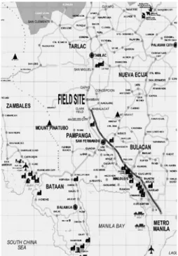
Three rural villages were covered by this proclamation San Vicente and Santo Niño in the town of Bamban, Tarlac; and Calumpang in Mabalacat, Pampanga in the Central Luzon administrative region (see figure 1). The CSEZ was formerly the home of the giant American military complex, Clark Air Base, where the United States (U.S.) 13th Air Force stationed itself (until it was forced to close down in 1992). As tracked in this article, the story of these villages begins in the early 1950s up to the present. Within this time frame, the community’s brief history can be roughly divided into six parts (Tadem 2005).
From the early 1950s to early 1960s, lowland farmers established and built a settled community in the area and occupied the best agricultural lands, oftentimes “purchasing” these from Ayta inhabitants in highly unequal transactions.2 The area was technically under the jurisdiction of the Clark Air Base, but since it lay outside the latter’s main perimeter, it was rarely monitored by the
2 Indigenous Ayta communities have lived and worked in the area since precolonial times. But being natural nomadic hunters and food gatherers, their ancestral lands encompassed a much larger area than that occupied by the three villages.
American military. In the early 1960s, a sugar boom in the country saw “capitalists” contract farmers to grow cane sugar, thereby introducing commercializing agriculture. Food crops such as rice and corn were supplanted in the process. The late 1960s–1970s was the period of left-wing insurgencies as guerrilla forces under the Communist Party of the Philippines – New People’s Army (CPP- NPA) entered the relatively isolated villages and converted them into a “red zone.”
FIGURE 1. Location of the three villages marked “Field Site”
From the 1980s to the early 1990s, the Ministry of Human Settlements (MHS), under then–First Lady Imelda Romualdez Marcos, spearheaded an intensive state intervention program through an integrated area rural development project. It was at this stage that the three villages collectively became known as Sacobia.
From 1991 to 1992, the Mt. Pinatubo eruptions devastated the area and ended the rural development project. The eruptions also caused
the evacuation and eventual relocation of the residents, including the Ayta communities, to resettlement areas in the lowlands.
When the eruptions abated, however, most of the residents returned to the three villages. From 1996 onward, the area was incorporated by the CSEZ.
What are Special Economic Zones?
Special economic zones (SEZs) are “demarcated geographic areas contained within a country’s national boundaries where the rules of business are different from those that prevail in the national territory” (Farole and Akinci 2011, 2). The rules and national laws that are differentiated have to do with “investment conditions, international trade and customs, taxation, and the regulatory environment.”
Effectively, SEZ rules and regulations are more free market–
oriented than prevailing national and subnational prescriptions, the latter being suspended within the SEZ’s confines. They include generous tax holidays on income taxes and as much as a 100-percent reduction on import and export duties, unrestricted repatriation of profits, government provisions for infrastructure including roads, bridges, utilities, and factory buildings. In return for these incentives, governments usually merely require the payment of a minimal percentage, e.g., 5 percent, of an SEZ investor-locator’s gross income. As a further incentive, governments normally relax laws protecting workers’ rights and welfare.
As outlined by Farole and Akinci (2011, 4) SEZs’ single most important feature and reason for being is to attract foreign direct investment (FDI). Secondly, they are meant to serve as “pressure valves” to alleviate large-scale unemployment and joblessness in traditional economic sectors. In many cases, they have remained enclaves of employment amid a sea of joblessness. Thirdly, as enclaves, SEZs support an economic reform strategy in the context
of a national export-oriented development policy often sluggish because of the maintenance of protective barriers. Fourth and last, SEZs act as experimental laboratories for the application of new policies and approaches related to “foreign direct investment, legal, land, labor, and even pricing policies […]” before being applied to the rest of the economy.
Concerns Over SEZs
SEZs have their advantages and disadvantages. Tandel (2011, 44–
56) cites the advantages of attracting FDI, generating employment opportunities, promoting exports, developing infrastructure facilities, and transferring technology. As to their disadvantages, Tandel also cites the loss of government revenue, the degeneration of agriculture and livelihood concerns, uneven regional development, employment of low-skilled labor, e.g., basic assembly and manual work, misuse of land for real estate development, and discrimination against existing industries.
A 2001 report by the United Nations Conference on Trade and Development (UNCTAD) uncovered that zones “created expressly to attract FDIs in export-oriented industries […] had often proved to be a constraint on the development of linkages”
(UNCTAD 2001, 15). Meanwhile, a World Bank study on SEZs emphasized that “maximizing the benefits of zones depends on the extent to which they are integrated with their host economies”
via the development of backward and forward linkages and not as enclaves where their economic impacts are suppressed (World Bank Foreign Investment Climate Advisory Service [FIAS]
2008, 50–51). Furthermore, it is recommended that economic impacts from integration with host economies be accompanied by “countrywide economic policy and structural reforms that enhance the competitiveness of domestic enterprises […].”
The Economist (2015a) writes that, in addition to the foregone tax revenues, SEZs also “create distortions inside economies, […] (and) are increasingly a haven for money-laundering through, for instance, the misinvoicing of exports.” Farole and Akinci (2011, 4), argue that although some SEZs “have been successful in generating exports and employment and come out marginally positive in cost-benefit assessments,” others, however, turn into virtual “white elephants.”
As such, investors are “taking advantage of tax breaks without producing substantial employment or export earnings,” becoming unsustainable because of rising labor costs or loss of preferential trade access, and failing “to extend benefits outside their enclaves or to contribute to upgrading of skills and the production base.”
A 2017 World Bank review of SEZs looked at 346 zones in 22 countries and questioned “whether SZEs have achieved their objectives.” It observed that “the majority of research has focused on the most successful cases,” thus raising “questions about the validity of generalizing the factors behind the success of a specific SEZ, which is embedded in specific economic, social, political, and legal contexts (World Bank 2017, 1).
Utilizing nightlights data through remote sensing technologies “as a proxy for economic activity,” the World Bank’s “results of the analysis have unveiled three significant findings” (World Bank 2017, 5):
(1) SEZs in the data set have a nondistinct economic trajectory relative to that of the countries in which they are located. Rather than catalyzing economic development, in the aggregate, most zones’ performance has resembled their national average.
(2) Zone growth is difficult to sustain over time. Generally, the economic dynamism of the most successful zones happens in their early years and slows over time, leading to the zones’ economic performance becoming similar to that of their surrounding areas.
(3) The majority of SEZ program features have had little bearing on zone performance. Features include incentive packages, and ownership and management schemes designed to attract and facilitate the dynamism of firms to/in the zone. The provision of corporate tax breaks has been of marginal importance, as have most nonfiscal benefits, such as the availability of national one-stop-shops and the independence of zone regulators. (World Bank 2017, 5)
Moberg (2014) argues that success indicators for SEZs must be redefined. The normal parameters of “employment, FDI, export, and production growth” and comparing these “to previous trends and to the rest of the country” are simply not adequate and may be too narrowly focused. Moberg then argues that “the existence of economic activity in an SEZ does not make it a net positive to the economy.”
Further validation of the above assessments of SEZs was provided by the 2019 UNCTAD World Investment Report, which devoted a whole chapter to SEZs. The report stated that “the performance of many zones remains below expectations, failing either to attract significant investment or to generate economic impact beyond their confines” and that “the continued enthusiasm for SEZs among governments around the world belies the impact of these zones, which is often mixed” (UNCTAD 2019, 3–4). It then further noted that although “there are many examples of highly successful SEZs [in] developing economies that followed export-oriented development strategies [and] played a key role in industrial transformation, […] examples abound, […] even in those economies, […] of zones that did not attract the anticipated influx of investors or did so only late” (UNCTAD 2019).
In latecomer countries, there are many more cases of zones that, once established by law, remained un- or underdeveloped for decades, and today’s stock of SEZs includes many underutilized
zones. Even where zones have successfully generated investment, jobs and exports, the benefits to the broader economy—a key part of their rationale—have often been hard to detect; many zones operate as enclaves, with few links to local suppliers and few spillovers (UNCTAD 2019, 3).
The UNCTAD Report not only expresses “doubts about the economic benefits of SEZs” but also questions the “very concept of establishing a regulatory regime distinct from—and in many respects laxer than the rest of the economy.” Concerns include environmental impact, social standards and labor conditions, with the latter focusing on “precarious employment arrangements and the discouragement of unions.”3
SEZ Operations as Land Grabs
SEZs’ takeover of large tracts of often productive agricultural lands can also be viewed within the context of the global phenomenon of land grabbing, which has come to characterize land transformations in recent years, including the conversion of peasant-controlled lands for commercial plantations and biofuel production. The term
“global land grab” has emerged as a “catch-all phrase to refer to the explosion of (trans)national commercial land transactions and land speculation in recent years…” (Borras and Franco 2012, 34).
These institutionalized forms of land grabbing are political in nature because they are essentially “control grabbing,” referring to the “capturing of power to control land and other associated resources like water, minerals, or forests, in order to control the benefits of its use” (Transnational Institute [TNI] 2013, 3).
3 The UNCTAD report, however, notes that “some studies also highlight the formal nature of jobs in SEZs and the often relatively high wages compared with those in the surrounding economy.”
Land grabbing needs to be seen in the context of the power of national and transnational capital and their desire for profit, which overrides existing meanings, uses and systems of management of the land that are rooted in local communities.
The global land grab is therefore an epitome of an ongoing and accelerating change in the meaning and use of the land and its associated resources (like water) from small-scale, labor- intensive uses like peasant farming for household consumption and local markets, toward large-scale, capital-intensive, [and]
resource-depleting uses (TNI 2013, 3).
Land grabs, however, are not just a matter of transferring control from local communities to state and corporate players. In fact, they also entail a “transformation of the social relations of nature,”
shifting from “small-scale agriculture, shifting cultivation and different forest products, and often regulated by customary laws” to large-scale corporate production systems As such, new and “different social relations of nature” emerge, which are “characterized by new social classes (capital and proletariat) and “the production of new political ecologies” (Pye, Radjawali, and Julia 2017, 379).
Rural Development Strategies
As SEZs of the industrial manufacturing and tourism-related types are located in rural areas, it is also instructive to view SEZs within the context of rural development strategies. In general, rural development programs may be classified according to three major categories: (1) growth-oriented and productivity-centered programs, also known as the technocratic model, (2) equity-oriented and redistributive programs, or the radical strategy, and (3) the reformist model (Sajogyo 1979, 109–138; Griffin 1979, 203–206;
Inayatullah and Wanasinghe 1979, 413–429).
The productivity and growth model falls under the overall rubric of “modernization,” in which rural development in developing countries is based on transforming the traditional, rural social structure through external linkages. With this, new attitudes and skills can be diffused among rural people, which would in turn
“support and generate impulses for development in the rural areas”
(Inayatullah 1979, 7–8). This model also includes the process of foreign capital intrusion in the agro-industry (de Janvry 1981, 225). In this context, one might look at the technological changes being conceived, mediated, and implemented by the state as being undertaken hand in hand with the penetration of capital in the rural areas. The model’s ultimate aim, then, is to transform noncapitalist and subsistence-oriented areas and bring them to the modern, market-oriented, and technologically advanced world.
The equity-oriented or radical approach is also known as the “human development model,” in which the redistribution of resources and popular empowerment are the major goals, and a high level of state intervention is often required (Sison and Valera 1991, 14–15; Inayatullah and Wanasinghe 1979, 21). Borras (1999), however, urged that the state’s role must be complemented by grassroots initiatives coming from autonomous rural organizations and other social movements based in the countryside. Ideologically, this strategy has its roots in noncapitalist and socialist views of development and is averse to relying on unregulated market forces.
The reformist strategy lays somewhere between the above two opposite poles of development strategies. This model attempts to show that the goals of equity and productivity are not mutually exclusive. In fact, they can coexist within a given national agrarian development plan or comprise dual components of a single rural program, such as resettlement projects or integrated rural development (IRD) programs. However, in the developing world, given the balance of social forces in rural areas and in cities where national policies are crafted, the two goals often run into conflict
with each other. Additionally, in the context of the modernization paradigm, the productivity-oriented approach has been the dominant rural model.
Griffin (1979) pointed out that governments adopting this compromise model often develop contradictory and inconsistent policies and programs. In attempting to “reconcile greater equity with faster growth,” the results were often “partial, fragmented, incomplete, and concentrated in certain regions to the exclusion of others.” In the end, a “dualistic and bi-modal” agricultural sector is the unfortunate outcome, benefiting mainly the well-to-do rural and urban elites, as well as foreign capital.
In the Philippines, the development of what would eventually be called SEZs began with the establishment of industrial estates (IE) on agricultural lands.
Sixto K. Roxas (1990b) believes that the IE strategy is harmful to the overall development of the Philippine economy, because it is being planned and implemented at the expense of agricultural development.
He suggests using "the community with a distinct ecological zone as the unit of organization."
Roxas looks at the issue of land use that goes “beyond the social scientists’ utility types...” He views it as one that will “be a total systemic economy or household based [...] (and where) community based lines project should start from the grassroots level, then to the national level [...] based on the criteria of highest and best use of the land...” Roxas (1990a and 1990c) then proposes that the “…the appropriate [...] agrarian reform module is precisely the organization and construction of such modern, agro-industrial communities built on smallholder owner operated, intensive, and diversified agriculture.”
SEZs in the Philippines
Philippine SEZs were established through Republic Act (R.A.) No. 7916, otherwise known as “The Special Economic Zone Act of 1995”, as amended by R.A. 8748. They are administered by the Philippine Economic Zone Authority (PEZA), which is attached to the Department of Trade and Industry (DTI). Incentives granted to business establishments operating within Philippine ecozones include:4
(1) Income tax holidays;
(2) Zero-percent duty on importation of capital equipment, spare parts, and accessories;
(3) Exemption from wharfage dues and export tax, import, or fees;
(4) Simplification of customs procedures; and,
(5) In lieu of all other taxes, businesses are required to pay only five percent of their gross income to the national government.
Philippine SEZs have gone beyond SEZs’ original intent to attract foreign investments in industrial and manufacturing activities.
They now include information technology parks, tourism ecozones, retirement and medical tourism economic zones, and warehousing/
logistics facilities—almost any “normal” business activity allowed in the country as a whole.5 This means that local investors can also
4 These incentives are found in the Omnibus Investments Code of 1987 and the SEZ Act of 1995. In 2018, however, the second package of the government’s tax reform program, the Corporate Recovery and Tax Incentives for Enterprises Act (CREATE) proposed the
“rationalization” of tax incentives that would effectively impose the normal corporate tax and abolish other tax holiday incentives in SEZs. In spite of this, successful lobbying by PEZA and big business groups resulted in the retention of the status quo in the CREATE law that was signed by President Duterte on March 26, 2021 (Ibanez 2020, Unciano 2021).
5 More of the Philippine Economic Zone Authority (PEZA)’s issuances on ecozone development can be seen here: http://www.peza.gov.ph/index.php/
pezaissuances/10-issuances/ecozone-development
be locators in Philippine SEZs. As of November 30, 2017, a total of 379 SEZs are operating in the Philippines.6 Information technology parks lead the list with 262, followed by manufacturing economic zones with 74. Agro-industrial zones have 22, tourism economic zones have 19, whereas medical tourism zones have two. This study focuses on SEZs of the original industrial–manufacturing type, as other kinds of SEZs will require a separate analysis and critique.
True to SEZs’ record in other parts of the world, the experience of Philippine SEZs have had mixed results. Manasan (2013, 4–5) outlines both the positive and negative outcomes.
On the positive side, PEZA improves the competitiveness of the country’s investment climate through its one-stop–shop model, which reduces the cost of doing business. FDIs in the country, as a whole, declined by 13% from 2006 to 2010, but FDIs in SEZs grew by 23% yearly in the same period. Thus, manufactured exports from SEZs grew annually by 5% from 2001 to 2009, whereas manufactured exports from non-SEZ firms declined by 9% yearly in the same period. Employment-wise, SEZ workers increased by 10% yearly from 2001 to 2010—or from 289,548 to 735,672. A rise in skill levels among SEZ workers was also noted, particularly in the electronics industries, especially with the rise in design- and research-related jobs.
On the negative side, Manasan notes that SEZ performance has been found to be deficient, as forward and backward linkages remain at a low level, thus preventing any “dynamic economic benefits.”
Additionally, locator investments have also been overly concentrated in the electrical and electrical machinery sectors with the decline of garment and textile manufacturing. This increases the country’s
6 As of March 2021, this is the latest tally posted by PEZA on its website: http://www.
peza.gov.ph/index.php/economic-zones/list-of-economic-zones
vulnerability to external shocks. Ninety percent of the top SEZ exporters are concentrated in these sectors.
The import-dependent nature of SEZ firms resulted in low value-added electronic products, which are mainly in the assembly of electronic components—given that the processes and designs of original manufactured products are done by the foreign- based mother company. Manasan observes that Filipino firms in the electronics sector are merely subcontracted to undertake low technology and low value-added operations.
As with other SEZs in Masan, South Korea; Jakarta, Indonesia;
Penang, Malaysia; Sri Lanka; and Shenzen, China; Manasan (2013, 6) concludes that for Philippine SEZs, the “costs […] outweigh their benefits,” as exemplified by the Bataan Export Processing Zone (BEPZ) and the Aurora Pacific Economic Zone and Freeport Authority (APECO), in which “costs (consisting primarily of infrastructure development costs) exceeded the benefits (as) measured in terms of employment and associated wage income of workers in the ecozone, exports and associated foreign exchange earnings, local input purchases by ecozone enterprises, and government revenues”
(Manasan 2013, 6).
Manasan also pointed out that it was not surprising that the number of locators in BEPZ, now called the Authority of the Freeport Area of Bataan (AFAB), in 2011 did not increase from the 1989 number.7 As for APECO, there were only ten approved locators as of April 2013. From this, only three of them have started doing business (APECO 2021). As of March 2021, APECO’s website identifies only
7 AFAB reports that the number of approved locators increased from 39 in 2010 to 163 in 2018, or a 236% rise. It is, however, difficult to ascertain the value of this information, as AFAB does not indicate how many have started operating nor does it provide a list of locators and their respective business activities (AFAB 2018).
two locators—J-PEC Development Corporation and Indus Pacifica Realty Corporation—about which no information is given.
As a tool for spurring and encouraging regional development, SEZs have also “been, almost without exception, a failure,” especially in geographical areas located far from developing regions and are of low economic density (Manasan 2013, 7 citing Farole 2011).
Worse, some SEZs have become conduits for smuggling in used automobiles and illegal gambling activities, such as the Subic Bay, Cagayan province, and Clark freeport zones. This has cost the Philippine government in lost taxes, e.g., duties, excise, and value- added tax (VAT), the amount of PHP 58 billion from 2007 to 2009 alone. In the case of car smuggling, this issue has also provided unfair competition to the local automobile industry (Manasan 2013, 7 citing Aldaba 2013).
The social costs of Philippine SEZs have also been disturbing.
The “broad structural-institutional context,” where land conversions and transformations are taking place, are now “driven by the anticipated commercial returns of large-scale land-use change of agricultural and forest lands (Cruz, Juliano and La Viña 2015, 3).
Aggressive giant property developers and SEZs in almost all regions are leading this drive, particularly as these have now become the most prominent form of land conversions and transformations.
Over the past years, there have been increasing reports about the displacement of Filipino rural communities from their inhabited lands, which is typically accompanied by human rights abuses, such as intimidation, forcible evictions, and killings. These all suggest that a more aggressive drive for commercially linked land seizures is underway (Cruz, Juliano and La Viña 2015, 3). Tadem (2014) points out that these activities are “destructive of agriculture and family farms,” displacing peasant households and depriving the latter of their sources of livelihood.
OXFAM International cites the specific case of APECO, in which “thousands of farmers, fishermen, and indigenous people have been challenging the project […] since 2007. Research indicates that APECO has violated these marginalized groups’ basic rights:
stripping them from the land, livelihoods, and ancestral ties that they have cultivated for generations and threatening massive environmental damage” (OXFAM International 2013). The APECO case illustrates the land grab phenomenon involving SEZs as described above.
Creating the Clark Special Economic Zone8
The Clark Special Economic Zone, located in Pampanga province in Central Luzon, illustrates the issues and concerns depicted above. On September 13, 1991, the Senate rejected the proposal to renew the RP- US Military Bases Treaty (Drogin 1991). The treaty’s extension was a hotly debated topic in Philippine politics. The United States (U.S.) government wanted its military forces to remain in the country, a position supported by then-President Corazon Aquino, who herself led public rallies in support of the U.S. position. However, the Senate, led by a known nationalist and opponent of U.S. military presence, Senate President Jovito Salonga, rejected the proposed renewal of the military agreement. The following year, American forces at both Clark Air Base and the Subic Naval Base left the country, ending 94 years of American military presence in the Philippines.
Despite pushing for the bases’ retention, the Philippine government had been, for many years, actually working on plans for alternative uses for the U.S. bases, even providing funds of this purpose. When the Senate voted against the bases, the government lost no time in
8 This section is excerpted with revisions from Tadem, Eduardo C. 2005. “Peasants and Outsiders: Change and Continuity in Three Rural Villages in the Philippines.” Unpublished PhD Dissertation submitted to the National University of Singapore, Southeast Asian Studies Program.
enacting legislation on bases conversion. On March 3, 1992, President Aquino signed into law Republic Act (R.A.) No. 7227, otherwise known as the Bases Conversion Development Act, “to accelerate the sound and balanced conversion into alternative productive uses of the Clark and Subic military reservations and their extensions (and) for the development and conversion to productive civilian use of the lands covered under the 1947 Military Bases Agreement between the Philippines and the United States of America.” To oversee this conversion and development process, the same law created a Bases Conversion and Development Authority (BCDA) as a government- owned and controlled corporation (GOCC).
R.A. 7227 also provided for the creation of a Special Economic Zone “covering the lands occupied by the Clark military reservations and its contiguous extensions” located within Angeles City, Mabalacat, and Porac, Pampanga; and Capas, Tarlac. Accordingly, President Fidel Ramos issued Proclamation No. 163 on April 13, 1993, creating the Clark Special Economic Zone (CSEZ) under the BCDA. Executive Order No. 80 further created the Clark Development Corporation (CDC) to manage the CSEZ. Meanwhile, an earlier Executive Order No. 62 issued on February 1993 stated that Clark Air Base is to be developed as an SEZ, with incentives and privileges similar to those granted to the Subic Special Economic and Free Port Zone.
The CDC’s initial “core area” of development covered 4,440 hectares, which corresponded to the actual Clark Air Base area.
However, provisions were added that allowed the CDC to extend its jurisdiction over the “contiguous areas” of the military reservation area, covering an additional 23,600 hectares.9
9 The core area would be divided into a civil aviation area (1,620 hectares); industrial area (1,020 hectares); new town area (1,000 hectares); and an institutional area, which covered universities, hospitals, and others (800 hectares). An expansion phase, with a total of 23,600 hectares, was earmarked for light-to-medium industry and agro-industrial development.
In the meantime, the Sacobia Development Authority (SDA) was removed from the Office of the President and transferred as an attached agency to the Department of Agriculture (DA) through Executive Order No. 292.10 However, it was not until June 14, 1996 that then-President Ramos issued Proclamation No. 805,
“redefining the Clark Special Economic Zone to include therein the 5,724 hectares (sic) property” in Bamban, Tarlac; and Mabalacat, Pampanga—“more commonly known as Sacobia.”11
On the same day, Ramos also issued Executive Order No. 344, which abolished the SDA and transferred its powers and functions to the CDC. This order effectively handed over jurisdiction of the entire Sacobia area to the CDC. The SDA became the Sacobia Development Department (SDD) under CDC. In 2002, it was later further downgraded to be part of the Sub-Zone Development Department.
Proclamation No. 805 envisioned Sacobia to be an area for agribusiness investments, as well as “a food basin for the CSEZ, the Central Luzon region, and the country in general with its abundant produce feeding other parts of the world to generate dollars for the economy.” This is an incredibly ambitious goal. Not even Imelda Marcos conceived of such a grandiose role for Sacobia when her MHS first conceived the IRD project. After all, the 1979 Sacobia Human Settlements Report had determined that of the 5,612 hectares covered by the IRD project, only 785 hectares (14%) were suitable for agricultural crop production.
10 This was a provision of Book IV, Chapter 6, § 47 of Exec. Ord. 292, the Administrative Code of 1987. What is surprising is that the mandated attachment of SDA to the Department of Agriculture was not implemented until after the 1992–1993 Mount Pinatubo eruptions.
11 This redefinition was necessary as R.A. 7227, in its delineation of the “contiguous extensions” of the Clark military reservation, excludes the town of Bamban, Tarlac in which two of the Sacobia barangays are situated.
The CDC would soon realize the impossible mission cut out for it. Subsequently, plans for Sacobia were scaled down to whatever potential investors would be willing to set up in the area. The first investor was an orchid farm that took up several hectares of productive farmland and encroached on existing family farms.
This generated resentment and protests from the affected farmers, prompting the investor to hire private armed guards. Chemicals used in the orchid farm also affected adjoining rice farms and soil fertility. Adding to the villagers’ hostility, most of the orchid workers were brought in from another province, leaving only two employment slots for Sacobia residents.
Executive Order No. 344, on the other hand, contained the ominous provision that “communities and permanent residents of Sacobia may be transferred and resettled by the CDC, at the expense of the BCDA, to give way to development projects in Sacobia.” This was, however, made contingent on “existing legal rights and valid ancestral domain claims.”
Attempting to exercise its presidentially mandated jurisdiction over the three villages, the CDC issued rules and regulations on housing and land use. These were, however, conveniently ignored or deliberately violated by the residents. Exasperated by the settlers’
refusal to cooperate, verbal threats were issued by CDC officials that the corporation would soon displace the settlers to make way for its unnamed plans and projects.
CDC Annual Reports
As of December 2020, the 2020 CDC Annual Report placed the number of locators at 1,226, 34 less than the 2019 number of 1,260 locators (see Figure 2). This constituted a drop of 3 percent (34 locators) from the 2019 total of 1,260 locators. Based on the 2019 annual report, commercial establishments made up 28.73 percent of the locators, followed by service providers (25.4%), industrial
firms (13.41%), information and communications technology (ICT) industry (11.83%), tourism (5.4%), logistics (4.4%), institutional (3.65%), aviation-related (3.02%), developer (2.38%), utility (1.51%) and agro-industrial (0.24%).12
FIGURE 2: Clark SEZ Locators
Source: Figure taken from Clark Development Corporation
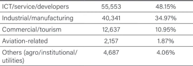
Total 2020 revenues of PHP 2.6 billion was 11% lower than 2019’s PHP 2.93 billion. The annual average revenue from 2016–2020 is PHP 2.32 billion. Meanwhile, the net income for 2020 was PHP 0.84 billion, 52% lower than the 2019 net income of PHP 1.75 billion. As of December 31, 2020, the total labor force of 115,375 workers was distributed as follows:
12 The author used the 2019 categories for locators as it is more detailed than the 2020 categories, the latter having lumped together agro/institutional/utilities in one category.
TABLE 1. Total labor force distribution (n = 115,375)
ICT/service/developers 55,553 48.15%
Industrial/manufacturing 40,341 34.97%
Commercial/tourism 12,637 10.95%
Aviation-related 2,157 1.87%
Others (agro/institutional/
utilities) 4,687 4.06%
Based on the reported number of workers in 2019 of 136,418, the Clark SEZ suffered a loss of 21,043 jobs (a 15% drop). This represented the first job reduction in six years. The reduced number of locators, incomes, and workforce could, of course, be accounted for by the COVID-19 pandemic’s effects.
Exports in the January–December 2020 period amounted to USD 8.15 billion, with 90% (USD 7.335 billion) accounted for by only three ICT corporations—Sfa Semicon, Texas Instruments, and Nanox—the same as in 2019. This reveals a skewed distribution system and unequal development among Clark locators, particularly as the remaining 1,223 locators accounted for only for 10% of exports (USD 815 million). Imports from January to December 2020 totalled USD 5.53 billion, with 87% of this accounted for by the same three ICT companies. Therefore, the net value from foreign trade was USD 2.62 billion.
Evaluating the Clark SEZ
Undoubtedly, the Clark SEZ has generated investments (both local and foreign) and generated income for the Philippine government in terms of total revenues (PHP 20 billion in 2020), accumulated earnings (PHP 8.78 billion in 2020), cash position (PHP 5.2 billion in 2020), and cash dividends (PHP 500 million in 2020 and PHP 1.1 billion in 2019) (CDC 2019; 2020). These numbers on locators, exports, and imports also show a thriving economic environment.
The question, however, is whether such monetary benefits affected the surrounding communities and local economies. This is a necessary and essential question to raise, especially given the above evaluations of SEZs’ overall performance with respect to contiguous geographical and demographic areas. To determine this impact, one must be appraised of the economic nature of Pampanga and Tarlac, the two provinces hosting the Clark SEZ.
For its main industries, the Pampanga economy has the following: (1) fishing, i.e., fishponds and lakes producing tilapia, mud fish, cattle fish, prawns, shrimps and crabs; (2) farming, i.e., rice, sugar cane, and corn; (3) food processing, i.e., pork and chicken tocino, hot dogs, hams, corned beef, carabeef tocino, tapa (seasoned dry meat), longganisa (sausages), and native sweets; and (4) cottage industries, e.g., wood carving, furniture, guitars, quilts, Christmas lanterns (parols), and other handicrafts.
On the other hand, the Tarlac economy is dominantly agricultural, producing rice, sugar cane, corn, coconut, vegetables, i.e., eggplant, garlic, and onions; and fruits, i.e., mango, banana, and calamansi. Secondarily, there is also fish production through fishponds; forest products (as Tarlac shares a boundary with Zambales); mineral reserves, i.e., manganese and iron; rice and corn mills, sawmills, and logging outfits; large sugar centrals; cottage industries, e.g., ceramics from clay, ylang-ylang products; and food processing, e.g., chicharon, muscovado products.
To date, there has been no shift from the above-mentioned economic activities to an SEZ’s supposedly more manufacturing and industrial-oriented thrusts.
The Clark SEZ remains an enclave, where aside from utilizing local labor, no forward or backward linkages exist with the local communities. Little upgrading of labor skills is therefore noted.
Employment benefits might also even be exaggerated as many workers come from outside the Central Luzon region where the two provinces are located and even from Visayas and Mindanao.
According to the Philippine Statistics Authority’s (PSA)
“Labor Force Participation, Employment, and Underemployment Rates” survey as of October 2020, the Central Luzon Region had an unemployment rate of 9.6% and an underemployment rate of 8% (PSA 2020). Given the regional labor force of 8.7 million, the above percentages translate into 834,336 unemployed and 495,280 underemployed persons, or 1.5 million without jobs or work less than what is needed to support themselves and their families.13 The Clark SEZ has, obviously, made little impact on the surrounding employment situation.
On the issue of foregone government revenues, the minuscule 5% corporate income tax on gross revenues meant that for 2019, taxes accruing to the national government amounted to a mere PHP 146,000 for 2019 and PHP 130,000 for 2020. On the other hand, if the regular non-SEZ tax rate of 30% was used, collected taxes would have amounted to PHP 879,000 for 2019 and PHP 780,000 for 2020.
Foregone revenues therefore amounted to PHP 733,000 for 2019 and PHP 650,000 for 2020 or PHP 1.383 million for two years alone.
This does not include the foregone revenues from the exemptions on export and import duties and wharfage
Ancestral Domain Claims
The CDC’s jurisdiction over the area, however, was seriously challenged by an unlikely protagonist: the Ayta indigenous communities of Sacobia belonging to the Magantsi subgroup. The 1987 Philippine Constitution provided for the recognition and
13 These official employment figures are thought to be gross underestimates of the real situation, particularly given PSA’s definition of employment, which referred to those who have worked at least one hour in the week previous to the survey (PSA 2021). The Social Weather Stations (SWS) rejects this definition. In its own survey of “joblessness,”
it calculates the rate for Luzon (outside of Metro Manila) to be 32.7% (SWS 2021). If the latter indicator is used, the estimated jobless persons in Central Luzon in 2020 could be as high as 2.8 million.
promotion of “the rights of indigenous cultural communities within the framework of national unity and development” (Const. art. II, § 22) and recognized the “prior rights […] of indigenous communities to their ancestral lands in the “disposition or utilization of […] natural resources” (Const. art. XIII, § 6). Republic Act No. 7586, otherwise known as the National Integrated Protected Areas System (NIPAS) Act, promulgated on June 1, 1992, provides for “due recognition of ancestral lands and customary rights […] within protected areas” and authorized the Department of Environment and Natural Resources (DENR) to “prescribe rules and regulations to govern ancestral lands” (Rep. Act No. 7586, 1992, § 13).14
Following these mandates, on January 15, 1993, DENR issued Administrative Order No. 2 (Series of 1993) prescribing the “rules and regulations for the identification, delineation, and recognition of ancestral land and domain claims” and defining ancestral domain as:
…lands and natural resources occupied or possessed by indigenous cultural communities, by themselves or through their ancestors, communally or individually, in accordance with their customs and traditions since time immemorial, continuously to the present except when interrupted by war, force majeur, or displacement by force, deceit, or stealth. It includes all adjacent areas generally belonging to them and which are necessary to ensure their economic, social, and cultural welfare (DENR Adm.
Order No. 2, 1996).
On June 15, 1995, the Bamban Ayta Tribal Association (BATA) filed an application claiming the area occupied by the villages of
14 The law further provided that the “DENR shall have no power to evict indigenous communities from their present occupancy nor resettle them to another area without their consent” and “that all rules and regulations, whether adversely affecting said communities or not, shall be subjected to notice and hearing to be participated in by members of concerned indigenous community.”
San Vicente, Sto. Niño, and Calumpang (the entire Sacobia area) as its ancestral domain with the DENR Indigenous Community Affairs Division. This claim was supported by the Office of Northern Cultural Communities (ONCC) and a legal support nongovernmental organization (NGO), Panlipi.
Upon being appraised of this claim, in August 1996, CDC wrote to the Tarlac Provincial DENR Head (PENRO), asserting that all ancestral land claims should be addressed to the development corporation. In later submissions, it argued that only areas actually occupied by indigenous peoples (IPs) should be included in the ancestral claim, and that its projects and plans for the Sacobia area should be respected.15
But following a series of consultations and investigations, including ocular surveys by a DENR Provincial Special Task Force on Ancestral Domains (PSTFAD) and presentation of proof and evidence by concerned Ayta communities,16 on September 23, 1997, the DENR Region III Executive Director endorsed a recommendation to grant the BATA application to the DENR Secretary. On November 21, 1997, or two years and four months after the claim was made, then–DENR Secretary Victor Ramos approved the issuance of Certificate of Ancestral Domain Claim (CADC) No. 107 to the Ayta Abelling tribe, covering 5,515 hectares in the three barangays.17
15 Such plans included the development of an “Entertainment City” in Sacobia to be dubbed as the “Las Vegas of Asia,” featuring casinos, hotels, theme parks, and golf courses (Gaillard et al. 2001, 6).
16 Sacobia Ayta tribal leaders presented historical accounts of their claim and documentation of traditional landmarks, including rivers, trees, hills, mountains, stone formations, hunting grounds, and their local names.
17 A CADC is preparatory to the issuance of a Certificate of Ancestral Domain Title (CADT) or Certificate of Ancestral Lands Title (CALT). The DENR order excluded 97 hectares of the original Sacobia area, which meant that this was the only part that CDC could retain for its plans and projects.
The Indigenous Peoples’ Rights Act
In the meantime, a landmark new legislation, the Indigenous Peoples Rights Act (IPRA) was signed into law on October 29, 1997. In its
“General Provisions”, aside from protecting the rights of indigenous cultural communities (ICCSs)/IPs18 their ancestral domains, the law also ensured “their economic, social and cultural well-being”
and recognized the “applicability of customary laws governing property rights or relations in determining the ownership and extent of ancestral domain” (Rep. Act No. 8371, ch. 1, § 2b). Furthermore, IPRA also provides that:
The State “shall recognize, respect and protect the rights of ICCs/IPs to preserve and develop their cultures, traditions and institutions. It shall consider these rights in the formulation of national laws and policies.” (Rep. Act No. 8371, ch. 1, § 2c)
“Respect for the cultural integrity” of IPs is repeatedly asserted in the IPRA’s general provisions, along with the assurance that “the State shall institute and establish the necessary mechanisms to enforce and guarantee the realization of these rights, taking into consideration their customs, traditions, values, beliefs, interests and institutions, and to adopt and implement measures to protect their rights to their ancestral domains” (Rep. Act No. 8371, ¶ 2)
IPRA also provides a unique concept of ancestral lands/domains, stating that these “shall include such concepts of territories which cover not only the physical environment but the total environment including the spiritual and cultural bonds to the areas which the ICCs/IPs possess, occupy and use and to which they have claims of ownership” (Rep. Act No. 8371, ch. 3, § 5) The law also stipulates IPs’ responsibilities to their ancestral domain, which includes the maintenance of ecological balance and the duty “to preserve,
18 IPRA uses the terms ICC and IP, interchangeably.
restore, and maintain a balanced ecology in the ancestral domain by protecting the flora and fauna, watershed areas, and other reserves”
(Rep. Act No. 8371, ch. 3, § 9a). Additionally, IPRA also provides that
“the Government shall take measures to prevent non-ICCs/IPs from taking advantage of the ICCs/IPs customs or lack of understanding of laws to secure ownership, possession of land belonging to said ICCs/IPs” (Rep. Act No. 8371, ch. 3, § 10).
The law also provides that “the State recognizes the inherent right of ICCs/IPs to self-governance and self-determination and respects the integrity of their values, practices and institutions”
(Rep. Act No. 8371, ch. 4, § 13). It also recognizes the IPs’ “right to participate in decision making […] in matters that may affect their rights, lives, and destinies through procedures determined by them” (Rep. Act No. 8371, ch. 4, § 16). IPRA also provides that IPs
“shall have the right to determine and decide their own priorities for development affecting their lives, beliefs, institutions, spiritual well-being, and the lands they own, occupy or use” and that “they shall participate in the formulation, implementation and evaluation of policies, plans and programs for national, regional and local development which may directly affect them” (Rep. Act No. 8371, ch.
4, § 17).
Chapter VI elaborates on the concept of “cultural integrity”
of IPs, reiterating that “the State shall respect, recognize and protect the right of ICCs/IPs to preserve and protect their culture, traditions and institutions” and that “it shall consider these rights in the formulation and application of national plans and policies”
(Rep. Act No. 8371, ch. 6, § 29). The chapter includes sections on IP rights with respect to educational systems, cultural diversity, community intellectual rights, religious cultural sites and ceremonies, indigenous knowledge systems and practices, biological and genetic resources, sustainable agrotechnical development, and on archaeological and historical sites.
The law created a new body, the National Commission on Indigenous Peoples (NCIP) as the “primary government agency responsible for the formulation and implementation of policies, plans and programs to recognize, promote, and protect the rights of ICCs/
IPs […] and the recognition of their ancestral domains” (Rep. Act No.
8371, ch. 7, § 38) The NCIP thus took over the DENR’s functions regarding ancestral lands, including the issuance of Certificates of Ancestral Land Domain (CADC) and Certificates of Ancestral Domain Titles (CADT), as seen in the following provisions:
SECTION 59. Certification Precondition. — All departments and other governmental agencies shall henceforth be strictly enjoined from issuing, renewing, or granting any concession, license or lease, or entering into any production-sharing agreement, without prior certification from the NCIP that the area affected does not overlap with any ancestral domain.
Such certification shall only be issued after a field-based investigation is conducted by the Ancestral Domains Office of the area concerned: Provided, That no certification shall be issued by the NCIP without the free and prior informed and written consent of ICCs/IPs concerned: Provided, further, That no department, government agency or government- owned or -controlled corporation may issue new concession, license, lease, or production sharing agreement while there is a pending application for a CADT: Provided, finally, That the ICCs/IPs shall have the right to stop or suspend, in accordance with this Act, any project that has not satisfied the requirement of this consultation process (Rep. Act No. 8371, ch. 8, § 59).
Disputes on the Ancestral Domain Claim
The Sacobia Aytas’ case, however, was weakened by an oversight regarding the CADC’s issuance. It was discovered that the certificate was issued in the name of the wrong Ayta tribe, the Abelling, rather than the actual residents, the Magantsi (or Maganchi) tribe. This
was confirmed by a survey conducted in the area by a joint agency team, which showed that 94 percent of the Sacobia Aytas indeed belonged to the Magantsi tribe, with only 2 percent Abelling.
CDC then seized upon the above error to pursue its adverse claim against CADC. A resolution purportedly signed by the “Indigenous People of Sacobia and the Council of Elders” and relayed by CDC President Romeo David to President Fidel Ramos on April 20,1998 called for the cancellation of CADC No. 107 and for a new CADC to be issued in the name of the Magantsi tribe “covering an area that is sufficient to their need and appropriate to their capabilities.” 19
Following this representation by CDC, on February 18, 1998, the Office of the President formed a joint action team (JAT) to resolve issues and disputes regarding the Sacobia CADC.20 The memorandum to this effect ordered the maintenance of the status quo in the area, i.e., no cancellation of CADCs and no new CADCs, and that “the CDC may pursue its project development” but with
“proper coordination with the indigenous people” (Gaillard et al.
2001). After several meetings, the JAT “confirmed the limits of the ancestral domain and sustained the indigenous people’s previous claims” and that “the Aytas have priority in the choice of lands for their communities” (Gaillard et al. 2001, 7). The CDC rejected the JAT’s recommendations and pursued the case with the Office of the President.
Although the issue was still pending, the CDC continued to treat the area as part of its jurisdiction and openly invited business interests to invest in the place. In 2001, the agency planned to build
19 Gaillard et al. (2001) say that this move was the result of CDC’s maneuvering among the Magantsi community to agitate it against the DENR.
20 The JAT was composed of the regional director of the Department of Trade and Industry as chair, a CDC representative, the DENR regional director, barangay chairmen in the area, and one representative each from the academe, i.e., historians, in Tarlac and Pampanga. Later, NCIP was included in the team.
a resettlement center for Aytas on the banks of Sapang Marimla.
This was, however, rejected by the Aytas who came down from the mountains to hold a protest rally at the CDC offices (Gaillard et al., 2001, 7).
In an undated document, former San Vicente Brgy. Captain P.B. Ledda reported on what he calls “irregular and unprofessional activities” by CDC in the Sacobia area (Ledda n.d.). In 1999, Brgy.
Calumpang put up a billboard stating that 5,515 hectares of the 5,612-hectare Sacobia had been awarded to the Aytas through a CADC. The billboard was then stolen. The barangay put up a concrete structure instead. On June 18, 1999, CDC attempted to put up its own billboard in Brgy. Calumpang, but this was resisted by the residents—majority of whom were Aytas armed with bows and arrows. CDC was able to erect one in San Vicente, but it was dismantled on June 20, 1999.
Ledda says that CDC illegally deployed security guards, which
“saturated a peaceful barangay” with seven posts manned for 24 hours—“a show of force that is used for harassment.” Billboards with “no trespassing” signs have been erected, which “limits [sic]
movements of residents within the barangay community.” He also reported that CDC prevented farmers from “tilling idle and/or vacant lands in San Vicente and Sto. Nino and “seized the former Bureau of Plant Industry area with its 200 fruit-bearing mango trees, denying management its harvest rights.”
Non-Ayta Settlers
The CADC dispute left non-Ayta families of the three villages wondering about their own future. They asked whether they will be deprived of their lands if and when the CADC is enforced, and a title is finally granted to the Ayta community in Sacobia. The JAT had asked this question in a formal letter to the DENR, but the reply sent by the DENR’s Office of the Undersecretary for
Legal and Legislative Affairs was ambiguous and open to various interpretations. It, however, left open the possibility that non-Aytas could be beneficiaries of a CADC. 21
However, lowlander settlers have their own gripe against CDC.
The threat of CDC’s expropriation hangs over their heads. In addition, land encroachments by CDC infrastructure projects and the orchid investor soured relations between the two parties. In an interview, former San Vicente Brgy. Captain Roberto Gonzales reported that the situation of the land issue became worse now than during the SDA days. Also, if CDC had tried to dispossess the farmers of their lands, there would be resistance, and violence could ensue—perhaps not against persons but against equipment.
Somehow, the threat of dispossession of the Sacobia farmholders was brought to the attention of the lower house of Congress. The House Committee on Agrarian Reform held hearings on March 19, April 21, and June 4, 2003. About 80–100 residents (including some from Macapagal village) went in three minibuses to Manila. San Vicente resident Manuel Cortez said that during the hearing, CDC Vice President Douglas Yballe could not reply to a question about where farmers’ rights end and CDC’s begin. A Committee member admonished him: “Kayo yung may heavy equipment. Kahit saan pwede kayo. Bakit yung may mga tao, kinukuha niyo?” (“You have the heavy equipment. You can reach anywhere. Why choose areas which people have already developed?”)
In 2007, the Sacobia area was renamed Clark Freeport Philippines and entitled investors to the same tax-free and other duty-free privileges enjoyed by their counterparts at other special
21 In his May 4, 1998 letter to the JAT, DENR Undersecretary Santiago Rodriguez said that a CADC could apply to non-Aytas so long as they are “recognized by the whole community, in accordance with its customs and traditions” and “shares the same language, customs, traditions, and other distinctive traditional cultural traits of that community.”
economic zones. Later, the area was further renamed Clark Special Economic Zone.
The CADT and the “Joint Management Agreement”
The much-awaited CADT, dated April 17, 2009, was finally released in the name of the Bamban Ayta Tribal Association (BATA) to 10,323.31 hectares of the Clark subzone (NCIP 2009). This superceded the earlier CADC and formalized the Aytas’ right to their ancestral land. The CADT issuance came five years after the NCIP had issued a resolution on November 10, 2004 approving the issuance of the title. What is surprising is that the original land area of 5,600 hectares covering the three villages of San Vicente, Calumpang, and Sto. Nino and the Ayta villages of San Martin, Burog, and Sta. Rosa had been expanded almost two-fold to 10,323 hectares.
CDC officials are unable to explain this discrepancy except to say that they simply accommodated the Ayta tribal leaders’ demands.
This question was later responded to by then–NCIP Regional Director Salong Sunggod, who, in an interview on May 15, 2008 at his office in San Fernando, Pampanga, said that the increase in CADT area was the result of a resurvey conducted on Ayta ancestral lands in the area.
Two years before the CADT issuance, however, on December 6, 2007, a joint management agreement (JMA) was signed between three parties: the Clark Development Corporation (CDC), the NCIP, and “Tribong Ayta.” The latter was represented by BATA Chair Oscar Rivera.
JMA Provisions
Was the JMA between the CDC and the Ayta tribal association an agreement that protected the ancestral land rights on an indigenous community that had possessed legal title to the lands in question?
Under “I. Layunin ng Kasunduan (Objectives of Agreement),” the following provisions are stated:
(a) Kilalanin ang Karapatan ng mga Tribong Ayta upang maitaguyod at maiangat ang kanilang pang-ekonomiya at panlipunan na kalagayan alinsunod sa programa ng pamahalaan para sa mga katutubo sa Pilipinas (Recognize the rights of the Ayta tribe in order to advance and upgrade their economic and social conditions in accordance with government programs for the indigenous in the Philippines);
(2) Magkaloob ng maayos na pagpapaunlad at pamamahala ng lugar na sakop ng Kasunduan na ito alinsunod sa layunin ng pamahalaan at tulong-tulong na pagunlad (cooperative development) at Plano ng Pagpapaunlad ng CDC para sa CSEZ (CDC Master Development Plan) at ng lupaing ninuno (Undertake an orderly development and administration of the area under the Agreement’s scope in accordance with the objectives of the government and cooperative development and the CDC Master Development Plan and of the ancestral land);
(3) Matiyak ang epektibo at tuloy-tuloy na pagpapaunlad ng ekonomiya at seguridad sa panlipunang kalagayan, katulad ng trabaho at ibang pang-ekonomiyang pangkaunlaran, para sa Tribong Ayta (Ensure the effective and continuing economic development and security of social conditions, such as employment and other economic development for the Ayta tribe) (CDC, NCIP, and Tribong Ayta 2007).
The above provisions seem to pay mere lip service to the recognition of the Aytas’ rights to develop their ancestral lands, as this is hampered by the conditionality that this be tied to government and CDC plans and programs. Rather than the innocuous reference to “government programs,” the JMA could have been strengthened by direct reference to the IPRA provisions that includes the all- important provision for “respect for the cultural integrity” of ICCs/
IPs and their customary laws and practices in crafting any IP- related development plan.
Was the JMA an agreement that granted equal rights to the Aytas vis-à -vis the CDC, and did it really provide for “joint management”
of the ancestral land? The author consulted a lawyer affiliated with the Free Legal Assistance Group (FLAG) and got this response:
The JMA is skewed against the IPs in the area and in favor of CDC and the investors it serves. The IPs are reduced to “beneficiaries”
of whatever jobs investors in ancestral lands may generate in a CDC-planned and CDC-driven initiative, rather than equal partners in development. This is paternalism that is used to cloak a virtual land grab of ancestral domain lands.
To support his conclusion, the FLAG lawyer cites the JMA provisions that are in “II: Pagpapaunlad ng Ekonomiya at Panlipunan na Kalagayan (Development of Social and Economic Conditions)”:
II. A.b. Ang pamamahala ng anumang plano ukol sa turismo, komersyal, industriyal, pang–agro-industriyal at iba pang uri ng pagpapaunlad sa lugar ay isasailalim sa epektibong pamamaraan at implementasyon ng CDC (The administration of any plan on tourism, commercial, industrial, agro-industrial and other development plans in the area will be under the effective system and implementation of the CDC); and
II. A.d. Siguraduhin na ang lahat ng benepisaryo ng Kasunduan na ito ay siyang pangunahing mapagkakalooban ng karampatang trabaho sa anumang proyekto na itatayo sa lugar (Ensure that all the beneficiaries of this Agreement will be granted priority for appropriate employment in any project that will be set up in the area) (CDC, NCIP, and Tribong Ayta 2007).
An important feature of the JMA is the stipulation that 20 percent of income from any lease agreements on the land covered by the CADT will be given to the Ayta association, i.e., BATA.
Meanwhile, the remaining 80 percent will be retained by CDC.
The income accuring to BATA will be used for development and livelihood projects among the Ayta communities according to an approved plan. The FLAG lawyer, however, observes that:
The 80–20 split is obviously not pro-IP. More than this, it is a split of the net income, reckoned only after deducting from gross incomes all “maintenance expenses” incurred by investors. This is open to abuse especially as they are unaccompanied in the Agreement by strong audit and transparency standards and mechanisms.
To add to the FLAG lawyer’s evaluation, the JMA also contains the provision that “any development plan or project that will be established in the area covered by this Agreement should be in accordance with the CDC Master Development Plan and the Ancestral Domain Sustainable Development and Protection Plan (ADSPP). (Ano mang plano ng pagpapaunlad o proyekto na ipapatayo sa lugar na sakop ng Kasunduan na ito ay dapat ayon sa Plano ng Pagpapaunlad ng CDC sa CSEZ at Ancestral Domain Sustainable Development and Protection Plan [ADSPP]) (CDC, NCIP, and Tribong Ayta 2007).
The ADSPP was supposed to be drawn up with CDC personnel’s technical assistance, but as will be shown below, no such plan ever came into being. Early on, a CDC official was informally notified of his designation as coordinator but did not receive a formal order and was thus unable to initiate any planning process. An initial plan was drawn up for the utilization of an amount of PHP 1 million, but the items included mainly vehicle purchases and per diem expenditures rather than actual development and livelihood projects.
II.B.a. is the provision for the formation of a Joint Development Committee (Komite ng Sama-Samang Pagpapaunlad) that will govern the JMA. This committee is also empowered to “examine or evaluate, approve, implement, and monitor all projects in the area covered by the Agreement” (susuri o gagawa ng ebalwasyon,
mag-aapruba, magsasagawa at magmomonitor ng lahat ng proyekto sa sakop na lugar ng Kasunduang ito). The JDC is composed of one representative each from the CDC, NCIP, and the Ayta tribe.
The FLAG lawyer, however, laments that only one seat in the JDC is given to the Ayta tribe, “despite the fact that they own the sole resource subject of the Agreement and are identified as its beneficiaries.” The JDC also sets the policies for the use of the Ayta Development Fund (ADF), in which the IPs’ 20-percent share is to be deposited, thus limiting the management of the ADF by the Ayta Development Committee (ADC).
The Aytas are further marginalized, and the CDC is privileged by its abrogation of the role of “development administrator” authorized to build infrastructure on ancestral lands, and with power over all rental, land use licensing, concessions, and all other income- generating activities in the ancestral lands while merely being
“obliged” to ensure employment for the IPs (§ III. 1a and b; CDC, NCIP, and Tribong Ayta 2007).
Strangely, the JMA grants the NICP unusual authority that further undermines the Aytas’ ancestral land ownership while favoring CDC’s interests. The FLAG lawyer notes in this regard that:
The NCIP, on the other hand, is empowered to interfere with, or undermine, arrangements organic to the IPs, in the service of CDC priorities. These organic IP arrangements which the NCIP may lawfully work to subvert under the JMA range from community leadership and representation structures, and the IP community’s autonomous initiatives with regard to the use of their own communal lands (§ III. 2; CDC, NCIP, and Tribong Ayta 2007).
The NCIP appears to have seriously considered the JMA provisions when it granted the Aytas the CADT two years after the agreement was drawn up. Thus, the CADT contains this limiting