50 Figure 37 Street grid of Al-Bsateen and Al-Balad, made by the author with the program space sentax. 52 Figure 40 Street orientation of Al-Bsateen and Al-Balad made by the author using space syntax.
LIST OF TABLES
Introduction
The main cause of the urban heat island effect is the change of land surfaces. Mitigation of the urban heat island effect can be achieved through the use of urban heat island green roofs.
This study also considers the factors of urban fabric, to know which one is in relation to factors influencing urban heat island. The methodological framework for this study followed a series of key steps to investigate the relationship between the urban fabric and the urban heat island.
Research structure
Types and impacts of urban heat islands, also an examination of strategies to reduce urban heat island impacts. City size, urban morphology and geographic location in Jeddah and connecting them to the urban heat island.
Introduction
A city with few tall buildings may have a weaker heat island than a city with many tall buildings. A city in a distinctly coastal sea breeze zone may generally, but not always, have a weaker heat island than a city further inland.
Phenomenon
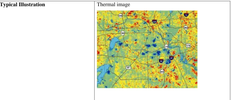
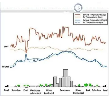
Surface Urban Heat Islands
The Surface Urban Heat Island has also been referred to as the remotely sensed Urban Heat Island as a result of the Urban Heat Island typically the knowledge of infrared mishandling that enables obtaining land surface temperatures has been discovered. Urban surface heat islands are generally present during the day and night; however it tends to be stronger throughout the night. The urban surface heat island varies seasonally and is typically largest in summer, due to changes in incoming radiation and the drier weather conditions associated with summer in most regions.
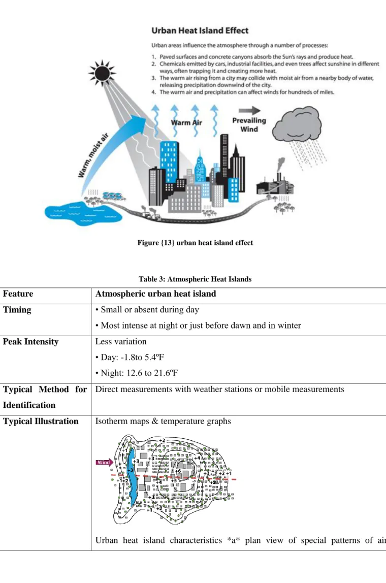
The urban heat island usually refers to the increase in temperature measured in the air near the surface within a settlement compared to the undeveloped environment. In urban areas, the hotter air compared to the cooler air near the countryside defines the region's urban heat islands. Figure {12}: Urban heat island effect in calm weather (left) and windy (right) . 2) Urban Heat Islands Boundary Layer: This layer starts from the upper lateral level and extends to the target where urban landscapes now have no impact on the atmosphere.
Influences of urban heat island
Urban heat islands (UHIs) have the potential to become one of the most important issues related to the urbanization and manufacturing of human civilization, as the inflated temperatures associated with urban heat islands tend to increase the threats to aggravating human health exhibited by thermal stress. As a result, the urban heat island has been a central theme among climatologists, and has been well documented in various metropolitan areas around the world. Urban Heat Island can increase energy demand for cooling and additional pressure to be dependent on the electricity grid, which can be attributed to most buildings and homes using cooling systems to scale down the indoor air temperature, especially during extreme heat events.
It is necessary to separate urban heat islands from the consequences of global warming, and at the same time perceive how these different phenomena move. The urban heat island additionally affects the availability and safety of water, as the lower water level and higher water temperature in the source, where there is too much drink, will increase the risk of contamination. Urban heat islands and high temperatures directly: reduce human health and well-being, reduce air and water quality, shorten the life cycle of infrastructure, and indirectly increase energy and water consumption (Gartland Harlan et al., 2006; EPAd, 2012). .
Strategies to Reduce Urban Heat Island Influences
Many communities are taking action to reduce urban heat islands using five main strategies: (U.S. Environmental Protection Agency, 2008). Installation of green roofs: The growth of a vegetative layer (plants, shrubs, grasses and/or trees) on a top reduces temperatures of the roof surface and also the nearby air and improves storm water management. The study (Cleare) investigates the relationship between the urban environment and the urban climate description of the three different types of heat islands and their relationship to the urban atmosphere.
In the city of Los Angeles, California as a model, the environmental factors associated with heat islands are described in detail including the effects on energy use, environmental pollution, and the overall health of the city's resident population. As the Los Angeles model illustrates, there are many steps that can be taken to reduce urban heat islands. The results of this study illustrate that building envelope greening is an efficient method to address urban heat island effects (Alexandria and Jones 2008).
Introduction
The two main variations within the climate of Saudi Arabia are often felt between the coastal areas and also the interior. A slight decrease in precipitation (less than 0.1 mm/day) is projected over northern Saudi Arabia by the turn of the twenty-first century. An increase of 0.1 mm/day is expected at the turn of the twenty-first century within the average annual surface evaporation for much of the Kingdom of Saudi Arabia, apart from a slender tang extending from north to center of Kingdom of Saudi Arabia extends.
Saudi Arabia is classified as a developing country in the United Nations climate talks, but with its GDP per capita among the highest in the world, the world's richest countries do not want to help them from an economic point of view. This is the reason why Saudi Arabia is now playing a more active role in implementing local policies towards a less carbon-based economy. We asked some of Saudi Arabia's delegates what they could tell us about climate policy in this country and the first thing Paul Movermann (17) from the Cité Scolaire Internationale said was that,.
Rapid Population Growth in Jeddah
Informal settlements quickly sprang up on major roads east of Jeddah and close to the airport in the north during a sprawl pattern (Aljoufie et al, 2013). These informal settlements have influenced the spatial growth, spatial structure and also the installation of Jeddah and presented huge challenges to Jeddah. These dramatic changes in Jeddah's land use have put a strain on transportation, public services and utilities.
Jeddah witnessed a dramatic increase in abstraction throughout this period, while also witnessing a vital infill development pattern on the northern and eastern sides of Jeddah. In all cultures studied so far, women who have completed at least some high school have fewer children on average and have children later in life than women with less education. Women who can own, inherit and manage property; divorce; to obtain credit; and participate in civic and political affairs on equal terms with men, they are more likely to defer.
City Size, Urban Morphology and Geographical Location
This, however, reflects an inevitable part of the green built in the city of Jeddah. All at the same time, the facts and figures of built-up land cover hold great promise to advance urban design in the city of Jeddah. Finally, if the design of the city government in Jeddah, the goal is to realize the various causes for the change of the built village and to realize productive design devices, the mitigation of the sense of isolation should be considered.
The document will help guide the evolution of the city's urban fabric in terms of commercial development and streetscape. Jeddah, on the east coast of the sea, is the second largest city in the Kingdom of Saudi Arabia. Since the earliest times, Jeddah has been a vital trading center and used to be the diplomatic capital of the region.
Reason for choosing the site
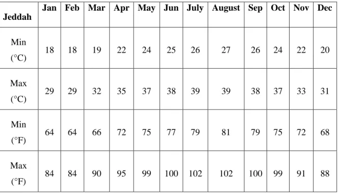
The winter temperature is relatively mild throughout the months of December and the Gregorian calendar month, which can vary from 15°C in the dead of night to 25°C in the afternoon. The leading common variety of downfall is that in the course of thunderstorms, which typically fall throughout the winter season as well as spring and fall. Jeddah has a wet climate and solar heat in the old city; all buildings are solved in a sustainable way to reduce heat and humidity.
They also have a system to store cold air in winter and reduce it in summer, revealing sustainable architectural features on the building. In al-balad, negative solar heating is better applied to the buildings they use for cooling in their buildings, to reduce heat, but towards the cretin of the building, which solves this problem, on the east and west sides, especially because of the direction of the sun. At the entrance to Souq al-Alawi in al-Balad district, Jeddah (Heat Islands).
Zone Two: al Basateen
The narrow side streets contain many bends and changes designed to achieve maximum shade. The most beautiful neighborhood of Jeddah "Al Basateen", the Emir of the Mecca region, contains the palace of Prince Khalid Al Faisal, where the Al Basateen district is characterized by many special entrances. Al-Basateen Neighborhood 2: Reality North of Verse Square West of Kubri Royal Hall.
Al-Basateen Neighborhood 3: The orchard district has special entrances and a unique layout design, covering an area of 21.5 square meters.
Introduction
Data Analysis
- The Characteristic of the Urban Planning of Al- Balad
- Comparison Between Al- Balad, and Al- Basateen in Terms of Different Micro-Climates Micro-Climates
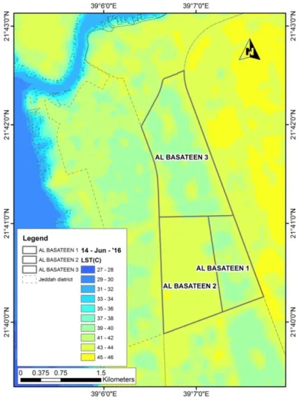
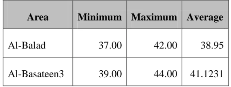
Al-Basateen is located in the northern part of Jeddah, which represents the modern urban layout of Jeddah. Comparison between Al-Balad and Al-Basatene in terms of different microclimates Microclimates Microclimates. Figure {54}: Distribution of the average temperature trend in the Al-Basateen 3 region (created by the author using the SPSS version 22 program).
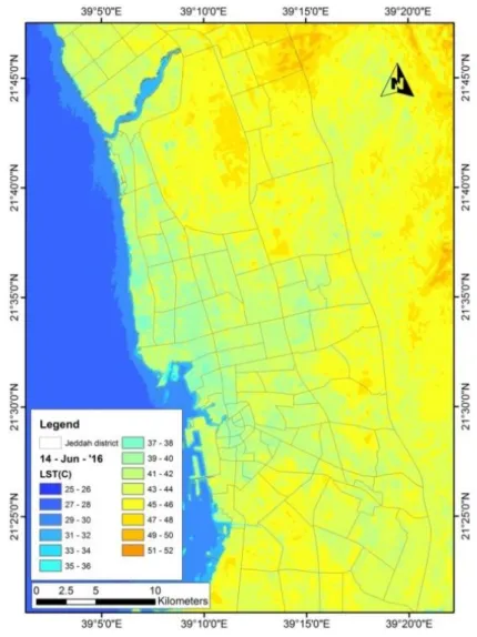
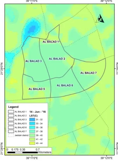
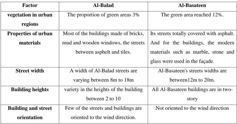
The study found a clear variation between the temperatures in Al-Balad and Al-Basateen district on 14 June 2016 at 13:00. The results of the mapping indicate that most rooms in Al-Balad and Al-Basateen exhibit lower temperatures than other areas; this can be seen in figures 33-34. In the case of Al-Basateen, it was calculated the proportion of green areas through the AutoCAD program, where it reached 12%.
Al-Balad streets are narrower than Al-Basateen streets, their width varies between 8m and 18m, or Al-Basateen varies between 12m and 20m. The buildings in the Al-Basateen area are designed in the form of two-story villas and have wide streets that cannot be overshadowed by the height of two stories. On the other hand, Al-.
Conclusions and Recommendations
Conclusions
ENVIRONMENT DESIGNER" solutions for the urban heat island Use of light-colored concrete and white roofs. Plants on the roof are excellent insulators during the summer and reduce the overall urban heat island effect. Green parking lots use green infrastructure strategies to reduce the impact of urban heat- island effect.
Urban Heat Island in Erbil City, Department of Physical Geography and Ecosystem Science, Lund University. The Impacts of Green Areas on Mitigating Urban Heat Island Effect: A Review (Published in 2014), the International Journal of Environmental Sustainability, Vol. The Current and Future Urban Heat Island Effect and Potential Mitigation Strategies in Greater Newark, New Jersey Region.