Any ground cover that includes natural permanent woody vegetation of any condition or age; except scrub fynbos or karoo. Canopies of the forest vegetation layer cover less than 75% and more than 35% of the land surface. Open woodland Natural woody vegetation of any height other than Fynbos or Karoo scrub.
Canopies of the forest vegetation layer cover less than 35% and more than 10% of the land surface. Canopies of the forest vegetation layer cover less than 10% and more than 5% of the land surface. lt;average tree height 20 m Medium rare. Differences in scale are known to affect the latter operation; however, part of the aim of this study would be to explore ways to overcome these challenges so that a sufficiently accurate and precise result can be obtained.
The purpose of including the mentioned categories is to add utility to the assessment in relation to estimating woody biomass yields that may have value in the form of wood fuel, carbon storage, etc. It is accepted that some of the geodata layers that will be applied to the primary remotely sensed data, will be of less accuracy. The result will be that some of the data tables will have a lower accuracy rating than others.
For different columns in the different tables it will therefore be necessary to qualify the level of accuracy of the reflected numbers.
IPCC Main Land Categories for LULUCF / AFOLU
Proposed land use change hierarchy for the NFRA
Main Land Use Land use Sub-categories
Definitions / descriptions
Buildings and facilities within/associated with built-up areas that serve the various public services of the community; including places of worship, schools, medical facilities, gathering places, parks, etc. Altered land within / associated with built-up areas, including any physical infrastructure that serves the purpose of sports and recreation; e.g. Parts of a built-up area or specific structure outside predominantly built-up areas in rural areas which serve primarily retail and business purposes - all developed areas (e.g. car parks) are included.
Parts of a built-up area, or defined areas outside primarily built-up areas that serve purposes of bulk storage of products or processing and manufacturing – including any associated transformed footprint areas. Built-up land with formal or informal structures of any density and associated footprint areas ("yards"), which are primarily used for and associated with human habitation Residential - Farm estate Farm yards, farm workers' houses. Lifestyle Estates and Smallholdings: the part of a smallholding/estate mainly related to residence (house, outbuildings and garden);.
Residential - formal suburban suburban built-up land primarily used for normal formal residential purposes (detached houses and associated yards >700m2). Built-up land used primarily for higher density residential purposes (detached or attached) on individual stands < 700 m2 (e.g. townhouses, apartment groups, low-cost regulated housing or self-built low-cost housing areas). Attached and/or stocked residential complexes and surrounding communal grounds (e.g. apartments and associated parking lots and open spaces).
Housing – Informal (rural) Self-built housing and associated land holdings typically in areas where property rights are governed under traditional systems. Built-up spaces and associated transformed footprint areas that serve temporary accommodation and leisure purposes (eg resorts and cottages). Communications Land transformed and managed for communications infrastructure: eg: masts and towers (total footprint area included).
Waste Disposal Land transformed and managed for waste disposal eg: incinerators, landfills etc. Defense and security Land transformed for defense and security development and maintenance. Disposal - Overburden Land area transformed and used for mining waste disposal and overburden or topsoil stockpiling. Disposal - Tailings Land area transformed and used for the disposal of tailings from mining activities Disposal - Water Land area transformed and used for the disposal of water from mining activities Buildings and infrastructure All areas occupied by buildings and other structures associated with mining and.
A DDENDUM II
T EMPLATES FOR A REA D ATA O UTPUT
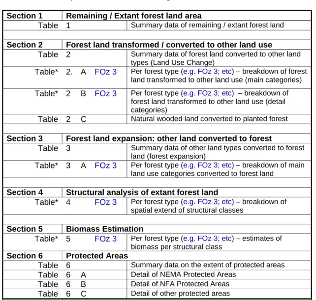
Structure of output data and numbering of tables
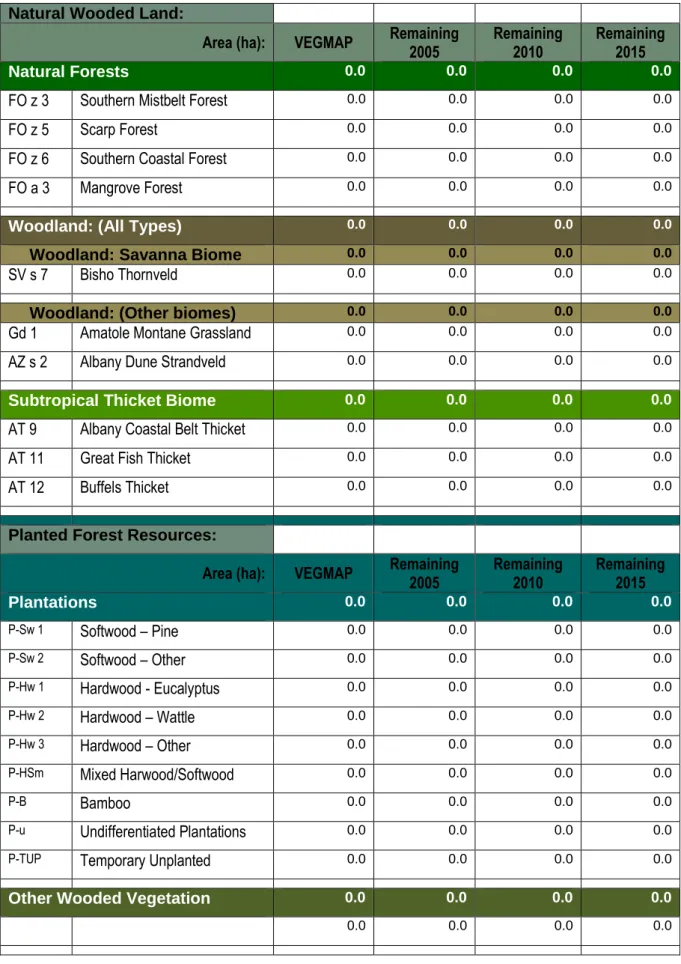
Remaining / Extant forest land area
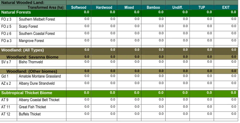
Forest land transformed / converted to other land use
Structural analysis of extant forest land
Biomass Estimation
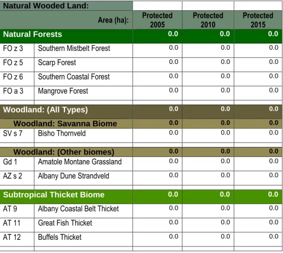
Protected Areas
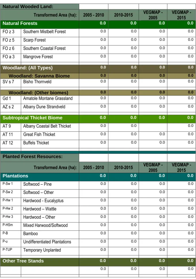
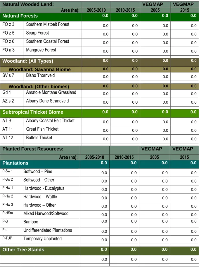
Natural Wooded Land
Area (ha): VEGMAP Remaining
2005 Remaining
2010 Remaining 2015
Planted Forest Resources
2005 VEGMAP - 2015
Agricultural production (perennials) Agricultural production (intensive systems) Agricultural livestock (planted pastures) Agricultural livestock (natural grazing) Agricultural livestock (intensive systems) Agricultural livestock (fish culture) Agricultural infrastructure. Settlements - Utility settlements - Sports and recreation settlements - Business and commercial settlements - Industrial and warehouse settlements - Residential settlements - Tourism. Infrastructure – Water Infrastructure – Electricity Infrastructure – Transport Infrastructure – Communication Infrastructure – Waste Management Infrastructure – Defence, Safety and Security.
Different land – drifting sand. Different land – erosion. Different land – bare soil. Different land – bare rock. Main forest resource category (e.g. natural forests;) Type 1 (specific type according to Annex I) Transformation classes Transformation classes. Residential – Formal (medium density) Residential – Formal (high density) Residential – Mixed formal and informal Residential – Informal (dense).
![Table 2 A [*Type – e.g. FOz 3 ]: F OREST L AND T RANSFORMED TO O THER L AND C LASSES](https://thumb-ap.123doks.com/thumbv2/pubpdfnet/8968013.41970/21.1262.87.1206.138.760/table-type-foz-f-orest-ransformed-ther-lasses.webp)
Total
Note: The "EXIT" category refers to plantation areas that have been taken out of production as part of the commercial forestry exit strategy or areas that have been cleared as part of invasive control eradication programs.
Specific floristic type as per Addendum I)
Note: (1) In the case of natural forests, the categories: "Dense", "Open" and "Sparsely Wooded" may actually occur on the ground; in that case, we are dealing with a degraded natural forest. 2) In the case of forest, the contiguous category may actually occur on the ground, in which case we may be dealing with encroached forest - depending on the specific forest type.
![Table 5 [*Type – e.g. FOz 3 ]: E STIMATION OF B IOMASS FROM R EMOTE S ENSING PER F OREST](https://thumb-ap.123doks.com/thumbv2/pubpdfnet/8968013.41970/29.892.151.808.149.872/table-type-foz-stimation-iomass-emote-ensing-orest.webp)
Area (ha): Protected
2005 Protected
2010 Protected 2015
Area (ha): National Park
Nature Reserve
Protected Environment
Area (ha): Forest Nature
Area)
Protected
Woodland* State Forest*
Area (ha): World Heritage
Areas
Mountain Catchment
Areas Act
A DDENDUM III
O UTLINE OF F INAL R EPORT
Main Part Subject / Headings Content Front Front Cover;
Climate
2. Elevation
Soil types
Forest Resources - 2005; 2010 and 2015 (natural forests)
Forest Resources - 2005; 2010 and 2015 (woodlands and thicket)
Forest Resources - 2005; 2010 and 2015 (plantations)
Forest Land Protected - 2015
A DDENDUM IV
D ATA S PECIFICATIONS AND D ATA I NPUTS P ROVIDED BY THE D EPARTMENT
S PATIAL D ATA S TANDARDS
Projections
Data Formats
Data acquisition and data management
Meta data summary information
Standard for Reporting Metadata (SANS 1878)
Spatial Representation Type
Keywords
Vertical Extent
Vertical Datum
Temporal Extent
Ellipsoid parameters
Projection parameters
Publication Date
Postal address Physical address
Data maintenance and update frequency
Distribution and constraints
I MAGERY A VAILABLE TO S ERVICE P ROVIDERS
Range
Resolution Reference year 2005
A DDENDUM V
A CCURACY A SSESSMENT R EPORT
I NPUT D ATA L IMITATIONS
Spatial raw data (Vector)
Other input data
S OURCES OF E RROR - D ATA A NALYSIS
M ITIGATION M EASURES
F INDINGS OF F IELD V ERIFICATION Sampling
Results
O VER - ALL A SSESSMENT OF A CCURACY
![Table 2 B [*Type – e.g. FOz 3 ]: F OREST L AND T RANSFORMED TO R ESIDENTIAL – DETAIL ANALYSIS](https://thumb-ap.123doks.com/thumbv2/pubpdfnet/8968013.41970/23.1262.84.1183.153.446/table-b-type-foz-orest-ransformed-esidential-analysis.webp)
![Table 3 A [*Type – e.g. FOz 3 ]: O THER L AND C LASSES C ONVERTED TO F OREST L AND](https://thumb-ap.123doks.com/thumbv2/pubpdfnet/8968013.41970/26.1262.180.1150.92.707/table-type-foz-o-ther-lasses-onverted-orest.webp)