This study examined the interactions between the social and physical environments as manifested in urban areas. The objective of this study was to examine the conditions of the park by focusing on the degree of influence of the social and physical environment on the area, the causes and consequences of the deterioration, and the solutions to the problem. The findings of the survey showed that Albert Park faces major problems, including crime, drug abuse and vagrancy, and that there are currently no adequate measures to prevent these problems.
From observations and conducted interviews, it was clear that the conditions in Albert Park are the result of low incomes of its residents, as well as vagrants. Therefore, Albert Park needs further research on appropriate planning and control measures to prevent the escalation of these poor conditions and achieve a sustainable urban area.
INTRODUCTION
- Background
- Location of the study area
- Motivation
- Hypothesis
- Research Problem
- Research Objectives
- Subsidiary Objectives
- Main research questions
- Subsidiary Questions
- Research Methodology
- Research Process
- Design of the study
- Land Use study
- Data sources
- Secondary Data Sources
- Sampling Procedure
- Data Collection
- Data analysis
- Problems encountered in the field
- Validity, Reliability and Rigour
- Dissertation Structure
- Summary
Albert Park suffered from serious mismanagement due to the lack of maintenance skills of the locals (Ibid). Albert Park is located in the south-east of the Durban Central Business District (CBD), a predominantly residential area characterized by medium and high-rise housing, with small formal and informal businesses operating along the roads (see Map 1 on page 3). The degeneration of Albert Park's built form is a function of physical and socio-economic dynamics.
Furthermore, it was looked at to what extent humans play a role in the degradation of the area. Observational research was conducted in Albert Park to gain a better understanding of the study area.
LITERATURE REVIEW
- Introduction
- Sustainable Development and Urban form
- The history of Urban Regeneration and Urban Form
- Urban Regeneration and Legislation in South Africa
- Interventions towards Urban Regeneration
- Inner City eThekwini Regeneration and Urban Management Programme (ITRUMP)
- Responses to urban Decay in South Africa
- Johannesburg
- Cape Town
- International cases dealing with urban regeneration
- Conclusion
This chapter presents a summary of the results and analysis, as well as recommendations for the study and sustainable urban form through urban regeneration. The first chapter describes the background of the research study which focused on Albert Park, eThekwini Municipality. The literature review is guided by the research objectives within this study such as the theories and knowledge of the topic.
The researcher explored the relevance of these concepts in the analysis of the built form in Albert Park. The decentralization of city management and administration, more specifically the establishment of metropolitan municipalities. ITRUMP was originally established to respond to the urgent need to industrialize inner city regeneration as a key priority.
These are two of the vital key elements proposed in previous crime prevention policies. According to the official website of the City of Johannesburg (2015), the provincial government is primarily one of the largest landowners in the Central Business District (CBD) occupying a large number of office blocks that were once an area occupied by the private sector. . Promoting private sector investment is a vital part of the regeneration strategy within the City of Johannesburg.
According to the Community Survey (2007), Cape Town, also known as Kaapstad, is the second most populous city in South Africa after Johannesburg and is the provincial capital and main city of the Western Cape. According to Engelbrecht (2004), it is argued that trends in globalization have intense implications for the restructuring of cities' urban form and sustainability. The chapter identified and compared different perceptions of authors in relation to the history, legislation, interventions and approaches of urban form and urban renewal literature.
CONCEPTUAL AND THEORETICAL FRAMEWORK
- Introduction
- Concepts informing this study
- Urban Regeneration, Gentrification and Urban renewal
- Blight and urban decay
- Sustainability
- Community Participation and Economic Development
- Theoretical Framework
- Structure of cities
- Models relevant to case study
- Theories governing urban renewal
- Collaborative planning
- The political economy
- Predicaments of urban renewal
- The role of planning policy in urban renewal
- Conclusion
McCarthy and Jones' arguments show that urban regeneration can help boost the economic, social and environmental aspects of the city. It is the "transformation of a working-class or vacant area of the central city into middle-class residential or commercial use" (Read 2008: xv). As a result of the many vehicles using that road, harmful pollutants as well as noise levels and disturbance lead to the decrease in the quality of life for the residents in the area (Whinston, 1966).
Another reason for economic weakening appears from the fall in the threshold of the commercial area. Poorly maintained properties then become vacant, resulting in the land use of the land being degraded (Smith, 1996:346). This can be seen on the outside of the buildings, which are not in good condition.
The concentric zone model is a model of the internal structure of the city, where the area is spatially arranged according to social groups in a series of rings. This makes renting closer to the city center cheaper than renting on the outskirts of the city. The name Multiple Nuclei is derived from the reasoning that it creates nodes or nuclei in other parts of the city in addition to the CBD.
It is concluded that renewal procedures worsen the socio-economic conditions of the poor and lower income groups (Squires, 1996). There are also cases where regeneration has increased the economic competitiveness of central business districts. According to Kihato (1999), policies aimed at encouraging the decentralization of the industries away from the city center.
THE CASE STUDY AREA
- Introduction
- Orientation to the case study area
- History and background of Albert Park
- Albert Park Today – Location
- Analysis of Albert Park
- Zoning of Albert Park
- The Existing Land-Use in Albert Park
- Land use within the study area
Albert Park is located in the south-east of the Durban CBD, this area is primarily a residential area characterized by medium and high-rise apartments, with small formal and informal businesses operating on roadsides. See Map 1 showing site maps of Albert Park as a study area in the context of Durban city centre. Albert Park is bounded by Russell Street to the west (see map 1 on page 3), Broad Street to the east, Smith Street to the north and St.
The analysis of Albert Park will primarily focus on the study's land use, which gives an insight into which part of the land is designated for which purpose. Finally, the area was observed in relation to the surrounding area within the framework of the Albert Park study area. Albert Park is located in the inner city of the CBD, which is situated to the south-east of the Durban CBD.
People were also forcibly removed and evicted from the apartments due to the Group Housing Act, but they intervened against these evictions; which led to Albert Park being unofficially one of the first integrated urban spaces (Mohamed, 1999: 6). The zoning in Albert Park is the intended land use that was to be carried out in the area and utilized for the relevant activities (see map 3 – Zoning map on page 44). The zoning of Albert Park is predominantly residential, General Residential 5 consists mostly of medium to high density residential apartments.
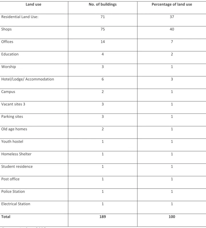
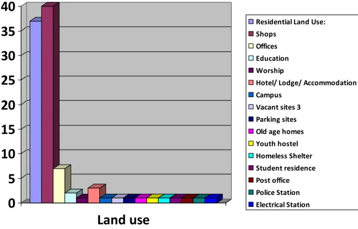
This enabled the researcher to determine if this was a contributing factor to the urban decay in Albert Park. The land use study also looked at whether the residents of Albert Park have access to basic infrastructure and services, this helped to evaluate whether relevant and necessary land use requirements are properly met to meet the needs of the people. Albert Park is therefore predominantly a residential area which is seen as an area that supports a wide range of mixed land uses such as schools, nursery schools and offices (refer to bar chart 1).

SUMMARY OF FINDINGS, CONCLUSIONS AND RECOMMENDATIONS
Introduction
Summary of findings
- Aesthetic environment
- Economic opportunities
- Socio-economic
- Quality of life
- Transport and Accessibility
- Sustainability
Over time, the appearance of the city had deteriorated and the nature of business and commerce had transformed (ibid). Photo 1.4: There is a small shop on Diakonia Avenue Photo 1.5: The salon located on Park Street 5.2.3 Socio-economic. It was noted that although there is a mixed number of racial groups within the CBD, Albert Park represented a very narrow demographic base.
The demographics of the area have since changed as less affluent non-white South African citizens now use the city centre. Photo 1.6: Predominant race group in Albert Park Photo 1.7: Citizens walking through the CBD 5.2.4 Quality of life. This was based on the observed poor living conditions, crime in the area and the aesthetic value of the neighbourhood.
One of the owners reported that the biggest problem in the area was that there were too many young people or students within the area causing trouble and noise pollution. The visibility of the police station and cameras was reported to have improved security within the area. Some of the residential buildings have camera inside the entrance to monitor people entering and exiting the building as well as fingerprint entry to enter the building improving security and fighting crime.
The Durban CBD is the most important transport hub in KwaZulu-Natal, as most users of the city's public transport travel to the CBD first and then proceed to their destination. 80% of the residents interviewed agreed that there is access to various modes of transport that enable movement to and from. This is therefore not sustainable for the environment, as it destroys the area and leads to the degradation of the area.
Results from Questionnaires with residents
Residents Opinions on Albert Park
Results from Questionnaires with Landlords and Tenants
50% of landlords surveyed indicated that crime was a major factor and as a result, cameras were installed at the entrance to the flats and fingerprint scanners were installed to prevent these activities.
Conclusion
Recommendations for the Renewal of Albert Park
Diamond, J and Liddle J, 2005, Management of Regeneration, Routledge, USA and Canada Elnokaly, A and Elseragy A 2011, Sustainable urban regeneration of historic city centers - lessons learned. 2011, Density & Sustainable Urban Development, Eco-city Summit Library Kihato, C, 1999, A Site for Sore Eyes: Johannesburg's Decay and Prospects for Renewal, Center for Policy Studies, Johannesburg. E, 2011, Place, race and belonging: a case study in Albert Park, Durban, University of KwaZulu Natal, Durban.
Prestige projects and urban renewal in the 1980s and 1990s: an overview of the benefits and limitations, planning practice and research. Mohamed, S I, 1999, Report on the Tenancy Survey and Building Profile in Albert Park, Organization of Civic Rights, October. An inner-city crime project implemented by the Organization of Civic Rights and Durban's CBD Crime Watch Co-.
S, 2003, Analysis of a decaying urban area and recommendations for its regeneration, a case study of South Beach, Durban, University of KwaZulu Natal, Durban. Squires, G.D., 1996, Partnership and the Pursuit of the Private City, in Fainstein, S and Campbell, S, Readings in Urban Theory, Blackwell Publishers Inc, Massachusetts, USA. Urban Task Force, 1999, Towards an Urban Renaissance: Final Report of the Urban Task Force chaired by Lord Rogers of Riverside (London: E and F. N Spoon).
Press, Massachusetts Institute of Technology Cambridge, Massachusetts and London, England Wyse, S.E., 2011, What is the difference between qualitative research and quantitative research?, Snap Surveys Ltd, UK. Young, A, 1993, United Nations Guidelines for Land Use Planning, Food and Agriculture Organization, Rome, Italy. What is your perception of the decay in the area and how would you advise reducing this in the area.