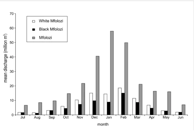
Flow in the Mfolozi River has been characterized as highly variable compared to the rest of the globe. The Simangeliso Park Authority, who gave us access to the protected part of the Mfolozi River floodplain.
Background to research
Generally, these environments are created along the drainage network, where flow is concentrated, and as such, wetlands in southern Africa can best be investigated using methods of fluvial geomorphology. The research described in this thesis aimed to develop a broad understanding of the origins of bottom-valley wetlands and floodplains in southern Africa and the biophysical factors influencing their sustainability.
Background to study area
Physiographically, the floodplain is bounded inland by the incised meanders of the Mfolozi River cut into rhyolite rocks of the Lebombo Group, and to the east by the Indian Ocean. Of these four models, three are represented in the Mfolozi floodplain, providing a unique opportunity to study the interactions between the models and increase understanding of the models themselves.
Aim and objectives
Structure of thesis
This is followed by an analysis of local scale geomorphology and sedimentology of the Mfolozi River floodplain (Chapter 4). Tributary drowning through trunk channel deterioration: the evolution of Lake Futululume on the Mfolozi River floodplain, KwaZulu-Natal, South Africa.
Irrigation Department Minutes on the History of the Canalization of the Umfolozi Swamp and St. Suspended particles and dynamics of the Mfolozi Estuary, Kwazulu-Natal: Implications for environmental management.
Systems, geomorphic thresholds and dynamic equilibrium as essential elements of understanding wetland formation and
Introduction and context
The placement of the Neogene axis resulted in the eastern regions of southern Africa rising approximately 200m, while the western region rose less, approximately 150m. The study of the geomorphology of wetlands therefore makes full use of the scalar and binding properties of system theory.
General systems theory and earth science
A simple system is one in which its future and past can be predicted using mechanical laws. A complex disorganized system is one in which many system components interact in a non-linear, seemingly random manner.
Process-response and nonlinear systems
Essentially, when a system is unstable, a small change can result in the system 'switching' to another endpoint that would be difficult, if not impossible, to predict (Phillips 2003). First, the parts of the system that undergo the most rapid change tend to be centralized.
Concepts of geomorphic equilibrium
This corresponds to the most fundamental equilibrium assumption, namely that the input of matter and energy must balance the output. Systems theory and equilibrium concepts can therefore be used to further improve the explanation of avulsion events.
Systems theory and wetland geomorphology
What is important is that the system must be close to the threshold for the change to occur at all. After such a bifurcation, different parts of the system may take different time to adjust.
Conclusion
Alluvial fans in the floodplain are more complex in terms of equilibrium history and tendency. This does not seem to be an adequate reason to assume that there is no tendency for equilibrium in alluvial fans.
Avulsions, channel evolution, and floodplain sedimentation rates of the anastomosing upper Columbia River, British Columbia, Canada. Middle and late Holocene avulsion history of the Rhine River (Rhine-Maas delta, The Netherlands).
Introduction
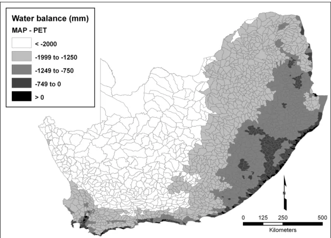
In addition, potential evapotranspiration is also high, with the result that large parts of the region experience a negative water balance (Figure 2). The macroscale analysis of climate and geomorphology in the region suggests two things about wetland formation on the subcontinent.
Methods
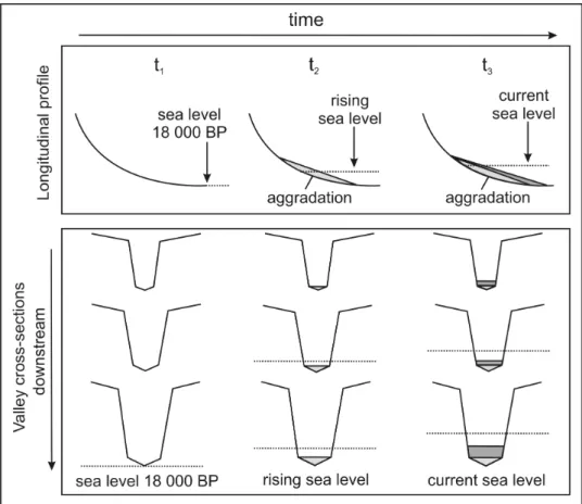
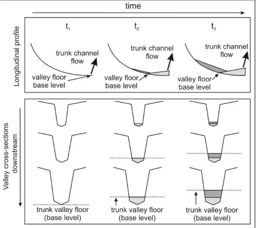
Deposition not only allows the formation of a certain geohydrological environment conducive to the development of wetland systems, but also causes adjustments to the longitudinal profile of the drainage line on which the wetland happens to occur. As sediment accumulates at the local base level, the slope at the upstream end of the depositional node is reduced, while conversely the slope steepens at the toe of the wetland system.
Results
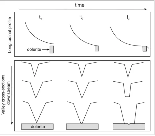
In the case of the Stillerust Vlei (section 3.1.1), the floodplain owes its origin to the rate at which the erosion of the soft shale from the Tarkastad Formation is stopped by the creation of an erosion-resistant dolerite dike downstream. The Futululu Wetland, a minor tributary to the Mfolozi floodplain, owes its origin to aggradation on the Mfolozi floodplain (a tribal-dominated tribal-tributary relationship) (section 3.1.3).
Discussion
Interception of the dolerite sill along the drainage line results in a resistive layer that acts as a local base level and momentarily interrupts incision. Thus, the development and maintenance of the local base level is the result of the further expansion of the valley on the slope, which is extremely uniform. Gradients are steep along the drainage line as the stream passes through the dolerite sill at the top of the wetland.
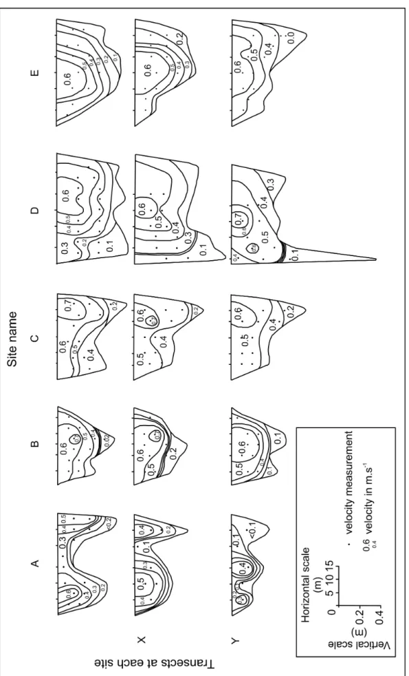
In the case of the Mfolozi floodplain, this latter process appears to be incomplete. During the erosion phase, the base level of the Futululu stream would have been determined by It turned out that erosion in the smaller drainage line wetlands was related to the location of the main channel in the valley.
Trunk-branch relationships are usually described in the context of the tributary's influence on the trunk's behavior. In the case of the Spitskop, the flow features of the Blood River appear to be covered with sediment. As the river enters the floodplain and flows on the prograding area of the fan, the slope is reduced to 0.04%.
Conclusion
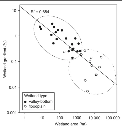
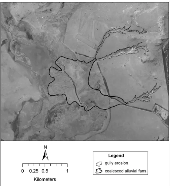
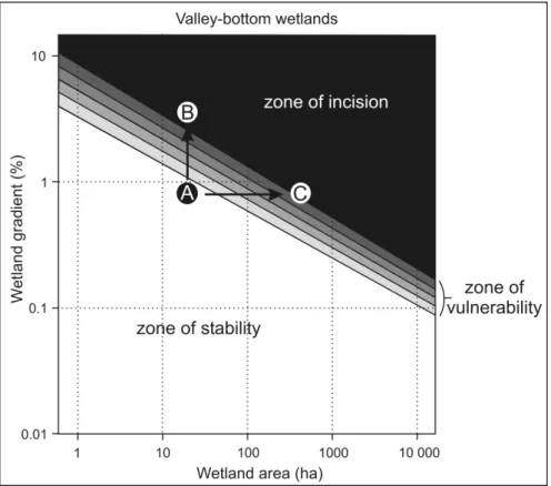
In general, gully stabilization will be most effective and economical during the early phases of degradation. Mapping gradients and wetland areas can therefore investigate which currently unincised wetlands are most vulnerable to future incision. These wetlands could be more closely monitored and their catchments managed on a precautionary basis, resulting in a more proactive approach to wetland restoration and management by being able to intervene before an erosion problem has become impractical.
In this way, the concept of a geomorphic threshold can be used to prioritize which wetlands should be monitored most closely, thereby reducing the cost of remediation should it become necessary. This is particularly useful when budgets are limited and specific wetlands need to be prioritized. However, the most likely way to cause the slope threshold to be exceeded is by increasing the size of the catchment discharge.
Since wetland area is an indirect measure of watershed discharge, an increase in discharge to a wetland is similar to an increase in wetland area, thereby moving the wetland from position A in Figure 19 to position C. Changes in watershed use, for example from agriculture to cities, can result in wetland incision with by creating runoff discharges that are too large for the slope of the wetland. The climate since the last ice age has become warmer and wetter, which is equivalent to moving from position A to position C in Figure 19.
The Wetlands of Natal (Part 3): the location, status and function of the priority wetlands in Natal. An analysis of the distribution of plant species on the floodplain of the Okavango River, Namibia, with respect to impacts of possible water extraction. Ellery WN, Grenfell MC, Kotze DC, McCarthy TS, Tooth S, Grundling PS, Grenfell, SE, Beckedahl H and Ramsay L.
The origin and evolution of two wetland systems in the KwaZulu-Natal Drakensberg foothills: implications for rehabilitation. Damming in a tributary valley by developing a river trunk floodplain: a case study from the Drakensberg foothills of eastern South Africa. Subsurface vegetation-induced carbonate precipitation as an aggradational process in the perennial wetlands of the Okavango fan (delta), Botswana.
Facies architecture and depositional dynamics of the Upper Permian Rangal Coal Masses, Bowen Basin, Australia. Geological controls on the behavior of alluvial rivers: a comparative study of three rivers in the South African Highveld.
Variable rivers: a new geomorphology? Case of the Mfolozi River, South Africa
Conclusions
The absence of peat in floodplain areas can be largely attributed to the highly seasonal nature of flood flows, and even to the irregularity of floodplains in the floodplains. Furthermore, there is evidence that the Mfolozi River floodplain has adapted geomorphically to the highly variable flow regime, and that the river's morphology is not in equilibrium with normal flow conditions. It appears that irregular large floods may be responsible for the majority of geomorphic changes in the upper and middle floodplains, causing avulsions and massive deposits.
The development of the floodplain also differs significantly from the dominant model of floodplain development in southern Africa by Tooth et al. The Mfolozi floodplain is an area of sediment filling and aggradation rather than lateral erosion and long-term incision. Channel migration and meandering curvature in the lower Mississippi River before major human alteration.
Organic matter deposition in the Saskatchewan River floodplain (Cumberland Marshes, Canada): effects of prograding avulsions. Controls on channel form and channel change in the Bell River, Eastern Cape, South Africa. Tributary drowning by trunk channel aggradation: the evolution of Lake Futululu in the Mfolozi River floodplain,.
Tributary drowning by trunk channel aggradation: the evolution of Lake Futululu on the Mfolozi River Floodplain,
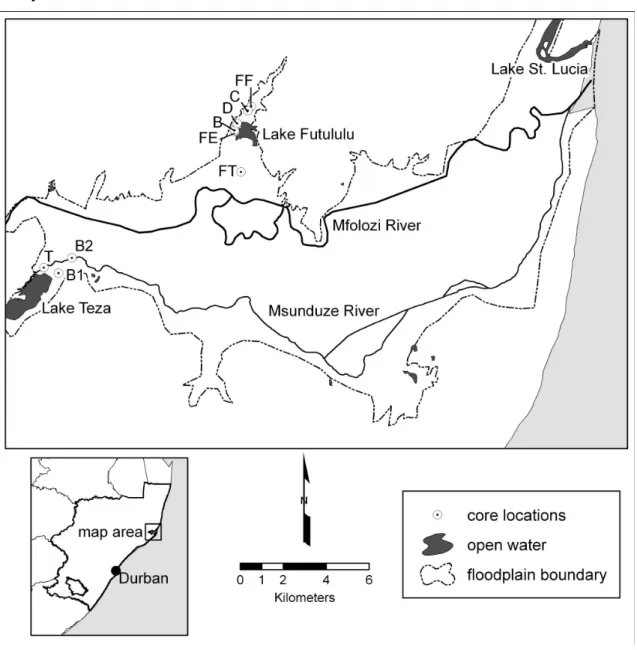
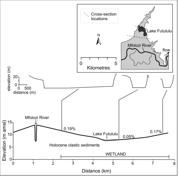
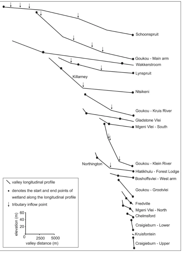
The chapter focuses primarily on the formation and development of a floodplain lake, Lake Futululu, in the floodplain of the Mfolozi River, north coast of KwaZulu-Natal. A longitudinal profile of the Futululu Valley (Figure 5, inset) illustrates the position of the valley in relation to the Mfolozi River. The embankments of the Mfolozi River are 6.4 m above the lowest point of the valley (core B in the inset of Figure 5).
The stratigraphy and organic content of the 6 Futululu cores are illustrated in Figures 5 and 6 respectively. An upward fine sand layer with an organic content of less than 6% marked the base of the core. The water table also sloped away from the center of the mound, towards the Mfolozi River in the north and Lake Teza in the south.
The sedimentology and organic content of the three cores associated with Lake Teza are illustrated in Figure 7. In contrast, the upper 1.9 m of the core was a coarse-to-upper sequence of very fine to medium sand. The base of the core was a 1.5 m deep fine-to-top sequence that graded from coarse silt to fine silt.