isprs annals IV 4 W3 21 2017
Teks penuh
Gambar
Garis besar
Dokumen terkait
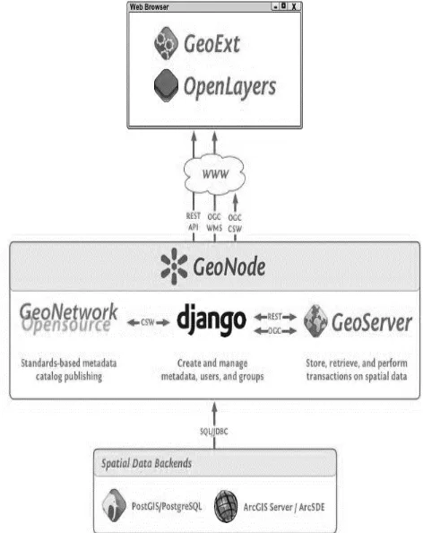
The concept of plug-ins to interact amongst themselves from one framework to another makes the integration of SDI and sensor web possible (Fig. The web enablement is shown
ISPRS Annals of the Photogrammetry, Remote Sensing and Spatial Information Sciences, Volume IV-4/W1, 2016 1st International Conference on Smart Data and Smart Cities, 30th UDMS,
ISPRS Annals of the Photogrammetry, Remote Sensing and Spatial Information Sciences, Volume IV-4/W1, 2016 1st International Conference on Smart Data and Smart Cities, 30th UDMS,
The histograms in Figure 9 show the derived errors to the ground truth poses. Figure 9.a and 9.b show the spatial errors of our VGG16-Net respectively SqueezePoseNet to ground
ISPRS Annals of the Photogrammetry, Remote Sensing and Spatial Information Sciences, Volume IV-2/W3, 2017 International Conference on Unmanned Aerial Vehicles in Geomatics,
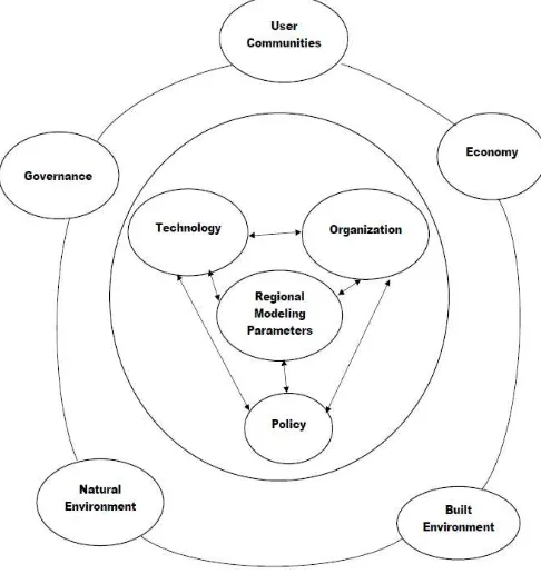
proposed by the EU initiative “smart islands” for the development of a road map of actions towards the smartification of an island. We have classified in those key
The enhanced smart point cloud developed model allows to bring intelligence to point clouds via 3 connected meta-models while linking available knowledge and classification
The International Archives of the Photogrammetry, Remote Sensing and Spatial Information Sciences, Volume XLII-4/W3, 2017 2nd International Conference on Smart Data and Smart
