isprsarchives XL 4 W5 25 2015
Teks penuh
Gambar
Dokumen terkait
The International Archives of the Photogrammetry, Remote Sensing and Spatial Information Sciences, Volume XL-4/W4, 2013 ISPRS Acquisition and Modelling of Indoor and
The rest of the paper is structured as follows: section 2 gives an overview of the system architecture and main functions; section 3 describes the approaches to integrate
The texture distortion features such as the slant, tilt and the curvature parameters are calculated from the 2D image by means of affine transformation measured between the
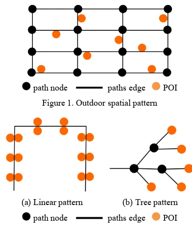
In this work, we describe a multi-step deviation process including semantic cleaning, walkable features extraction, Multi-Storey 2D Mapping and S-MAT implementation to
The results of vehicle detection and counting and also speed estimation is totally related to the quality of imaging, specifically the spatial resolution of the
At the end of 2011, OSM launched IndoorOSM, which is a tagging schema for indoor mapping following OSM The International Archives of the Photogrammetry, Remote Sensing
Findings from studies and research on spatial evaluation of regional landfills for infectious wastes in Hormozgan province are presented in this section including prioritization
All in all, in this study the following objectives discussed: 1- Extraction of spatial information which is embedded in Web documents: Spatial documents include spatially
