A PHOTOGRAMMETRIC APPRAOCH FOR AUTOMATIC TRAFFIC
ASSESSMENT USING CONVENTIONAL CCTV CAMERA
N. Zarrinpanjeh a, F. Dadrassjavan b, H. Fattahi c*
a Islamic Azad University of Qazvin - [email protected] b University of Tehran - [email protected] c Tehran Traffic Control Company - saran_hf @yahoo.com
KEY WORDS: Photogrammetry, Automatic Traffic Assessment, CCTV Camera
ABSTRACT:
One of the most practical tools for urban traffic monitoring is CCTV imaging which is widely used for traffic map generation and updating through human surveillance. But due to the expansion of urban road network and the use of huge number of CCTV cameras, visual inspection and updating of traffic sometimes seems to be ineffective and time consuming and therefore not providing real-time robust update. In this paper a method for vehicle detection accounting and speed estimation is proposed to give a more automated solution for traffic assessment. Through removing violating objects and detection of vehicles via morphological filtering and also classification of moving objects at the scene vehicles are counted and traffic speed is estimated. The proposed method is developed and tested using two datasets and evaluation values are computed. The results show that the successfulness of the algorithm decreases by about 12 % due to decrease in illumination quality of imagery.
* Corresponding author
1. INTRODUCTION
Acquiring reliable information about traffic condition in urban road network is crucial for traffic monitoring and management. One of the most practical tools for such task is the use of conventional closed circuit cameras (Song 2006). As transportation flow is monitored by visual inspection the current situation of traffic is assessed and then updated. But due to the expansion of urban road network and the use of huge number of CCTV cameras, visual inspection and updating of traffic sometimes seems to be ineffective and time consuming and therefore not providing real-time robust update. On the other hand traffic monitoring tools such as speed detectors, mechanical vehicle counter and radar based tools are found successful for such purposes but they are so expensive compared to conventional CCTV cameras to be installed in each and every corner of urban area. In this paper an automated approach suitable for conventional CCTV camera is proposed to evaluate road traffic to decrease the influence on human surveillance. The proposed method is focused on counting the number of moving vehicle and also estimating the instant speed of the traffic flow in specific periods of time (Ferrier etal., 1994).
In this paper, reviewing methods of road traffic assessment a camera based approach for road traffic assessment is presented. The proposed method is tested and evaluated using real CCTV imagery.
2. A REVIEW ON ROAD TRAFFIC MONITORING
There are many operational systems to facilitate the process of road traffic monitoring. These methods are designed and
developed to measure the road traffic condition in terms of vehicle counting and speed estimation. In general all traffic monitoring systems could be divided into two categories of active direct measurement systems and passive vision based optical measurement systems. Active Direct sensor consider mechanical, electrical or beam emitting tools to detect vehicle on the road. Solutions in this category require installation of specific tools at the place of surveillance and as a result are considered as expensive solutions. On the other hand camera based system use indirect approaches
2.1 Active Direct Systems
One of mostly used tools for traffic control for past few decades are Magnetic loops (Dhar, 2008). These devices are installed inside each traffic lane and counting vehicle passing over them. Some variants of the magnetic loop have been used to classify vehicles as well. Another efficient tool for traffic monitoring is microwave radars. Microwave radars detect vehicles through direct measurement procedures. Most microwave radar use the Doppler principle to detect vehicles. According to the Doppler principle the difference in frequency between the transmitted and received signals is proportional to the speed of the vehicle.
Laser based systems are for reliable counting, classifying and measuring speed of vehicles. On the other hand, Ultrasonic sensors consider sound waves to determine the presence or distance of an object. By measuring the time taken for the sound echo to return the distance of an object could be computed. The International Archives of the Photogrammetry, Remote Sensing and Spatial Information Sciences, Volume XL-1/W5, 2015
2.2 Passive Optical
Camera based systems are able to detect, count and classify vehicles. These systems use video image processors to identify vehicles and their traffic flow parameters by analysing imagery through image processing algorithms. Moreover, passive infrared detectors do not transmit energy but use an energy sensitive photon detector located at the optical focal plane to measure the infrared energy emitted by objects in the detector's field of view. Thus, when a vehicle enters the detection region of the device, it produces a change in energy which is sensed by the photon detector. This system can only detect the presence of vehicles and is not able provide any information regarding the speed of the vehicle. Change in weather conditions such as fog, rain or snow results in performance degradation of these systems.
3. PROPOSED PHOTOGRAMMETRIC APPROACH
FOR TRAFFIC MONITORING
In this study a vision based system based for traffic monitoring is proposed. A general overview of the algorithmic flow is present in figure 1. The algorithm starts with video stream reception and verification. At the first step the camera is initialized in terms of definition of the scene, object coordinated system and area of interest. The information is provided by user to the algorithm to initially construct image object transformation. The algorithm tries to keep the initialization configuration and restore it in case of violation. At the next step stability of the camera is verified. Any abrupt change in camera position and rotation angles is not tolerated and speed detection is stopped until camera stability is stablished. Then the illumination status is analysed which defines the acquisition exposure condition in order to tune vehicle detection parameters. The next step is dedicated to scene coordinate restitution. The algorithm constantly verifies if the xy coordinate systems is still valid so the speed detection precession is guaranteed. At the final step vehicle detection is applied on the verified image frame.
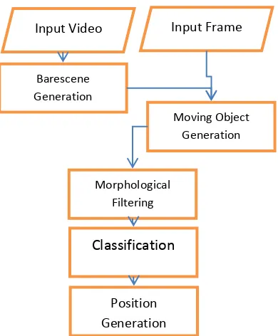
The flowchart of vehicle detection is presented in figure 2. Vehicle detection starts with Barescene generation from video stream. Barescene is defined as the image of road without any moving objects. Barescene is generated through median filtering of frames in different time epochs. Next, camera stability is checked during Barescene generation. Subtracting image frame from Barescene a trace of moving objects is generated. Through morphological filtering, trace of objects turn into detectable and countable entities. These entities are verified and classified with respect to size and area of the detected object. The position of each entity considered as the centre of detected object and is stored along with frame epoch and a view of detected entity. Processing the extracted entities position compared to frame rate the instant speed of vehicles are computed. It is recommended to compute speed from all available frames and consider the average speed as result speed value.
Figure 1: The flowchart of general processing of the algorithm.
Figure 2: Flowchart of vehicle detection using image frames. Input Video
3.1 Challenges of Vehicle Detection
The most challenging issue in the traffic monitoring is that the process of information generation should be applied fast enough to be considered real-time or near real-time. If the process of implication of algorithms is time consuming the results whether robust and reliable are not found suitable for real world applications. Moreover CCTV images usually suffer from low spatial resolution and the effects of compression applied to facilitate image transport and storage which reduces the information content of data and restricts the solutions to be logged. On the other hand CCTV cameras are built for surveillance and monitoring and therefore they are mostly equipped to rotate and zoom. Although these necessary capabilities provide widen monitoring perspectives but they extremely violate photogrammetric geometry in terms of ruining exterior and interior orientation of camera.
In normal situations the process of vehicle detection and traffic monitoring is not too hard to implicate but the problems occur when camera and environment conditions are far from what it is called ideal. Camera angle and more specifically the tilt angle of image acquisition is very important. If camera is set to be vertical with zero tilt angle the traffic assessment and vehicle counting is restricted due to small field of view of the camera. In reverse horizontal acquisition would intensify the scale variation due to tilt angle which is not suitable for geometric computations. On the other hand direct solar radiation at sunrise and sunset which results blooming effect reduces the information content of imagery and violates vehicle detection. This also happens in case of front view of vehicles with light on during the night. Additionally, as illumination intensity decrease during the night, vehicle detection and speed estimation get more sensitive especially in case of camera movement where relation between primary and secondary scene is hard to generate due to low information content of the imagery. In these cases it is recommended to use cameras pre-set option to skip restitution procedure.
Figure 3: Information content reduction due to illumination problems.
Figure 4: Blooming effect of car lights.
4. TESTS AND RESULTS
To test the capability of the proposed method tests are defined and applied using real data from Tehran Traffic Control Company and National Road Traffic Control Organization.
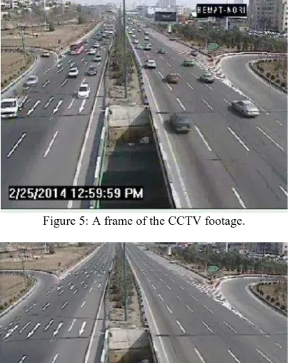
At first image frames are processed to generate Barescene. 11 frames within 10 seconds are chosen and pixels with median values in all 11 frames are assigned to generate Barescene. To avoid mistakes from comment and direction indicators on the screen 25 percent from top and bottom of the image is removed. It should be considered that in case of heavy traffic jams road Barescene generation should be applied on higher numbers of frames. Figure 5 shows a sample frame of the CCTV images. Figure 6 shows the results of Barescene generation on the selected frame.
Figure 5: A frame of the CCTV footage.
Figure 6: Barescene generation using median filtering.
One of the most critical processing of vehicle detection is the establishment of a robust transformation between image and object spaces. For the purpose four GCPs are measured on the screen. The object coordinate of GCPs are measured through field surveying. Assuming that the road surface is smooth enough to be considered planar, 2D projective model is chosen to transform 2D image coordinates into 2D ground coordinate system (equation 1). This enables the conversation of car movement in image space detected by the algorithm in different frame to speed of the vehicle.
(1)
Where X and Y represent object coordinate system and i and j are refer to as image coordinates. Coefficients are computed by the use of GCPs. Figure 7 shows the position of GCPS measured on the bed of the road connected to each other in shape of a foursquare.
Figure 7: Definition of ground coordinate system.
To minimize the computational cost of vehicle detection on the huge data sets especially in case of high definition images, the area of interest is defined and any necessary processing is restricted to the area of interest. Inserting the number of lanes and dividing the area of interest into lane numbers, individual inspection of each lane is possible. As a result over computation are avoided and real time and near real time traffic monitoring is found more feasible.
This also enables the algorithm to monitor multiple lanes even in reverse directions.
Figure 8: Definition of rea of interest and number of lanes.
Figure 9 shows the result of vehicle detection on the selected area. As illustrated 5 objects are detected on the screen and only one item is detected as a robust object for speed estimation. As a matter of fact comparing the extracted objects size and location witch coordinate system and the scale of imagery, besides counting and classifying vehicles, it is decided whether the information is robust enough to compute the speed. As shown in figure 9 only one vehicle is considered for speed estimation. The decision is made via counting the number of pixels with respect to image spatial resolution.
Figure 9: The results of vehicle detection.
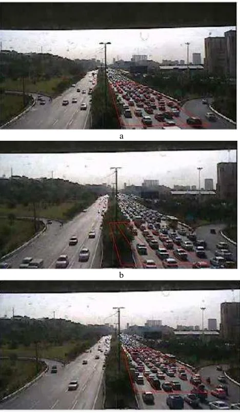
To restore ground coordinate transform in case of changes in camera viewing angle SIFT algorithms are used. Figure 10a
shows the position of ground control points in form of a grid. As shown in figure 10b a change in camera viewing angle induced by human user is detectable. This mostly happens when the camera is not equipped with pre-setting systems. Therefore returning back to initial imaging angle is not executed exactly to the same point. In figure 10c the result of sift algorithm to restore grid position is shown. As tested with different viewing angle the algorithm is successful in restoring position of camera view if compared imageries enjoy more than 50 percent overlap and scene illumination is enough for object detection. In other words the algorithm is not successful images during the night.
a
b
c
Figure 10: the results of camera position restoring. a) Initial image. b) Unadjusted image. c) Restored position.
Visual inspection of results shows that the algorithm is successful to count vehicles and estimate instant speed where the mentioned visual constraints are respected. Image quality reduction by any reason reduces the success of the method. Therefore, an analytical inspection on accuracy of the estimated speed is proposed. Moreover, for factious and figurative evaluation of the efficiency of the proposed method completeness correctness and quality criteria for vehicle counting in different condition are computed and analysed. As shown in table 1 results of evaluation of vehicle counting is presented. Dataset#1 refers to imaging with adequate amount of The International Archives of the Photogrammetry, Remote Sensing and Spatial Information Sciences, Volume XL-1/W5, 2015
light (daylight) and in opposite dataset#2 suffers from low illumination during sunrise and sunset.
As shown in table 1 the algorithm is 92% successful with respect to quality of results for dataset#1. In return due to illumination decrease vehicle detection quality of results has decreased to 80.2 %.
Table 1: Evaluation of results of vehicle counting Dataset Correctness Completeness Quality Dataset#1 96.3 95.1 92.6 Dataset#2 86.9 83.4 80.2
5. CONCLUSIONS
In this paper a method for traffic monitoring of roads is proposed developed and evaluated. According to the specification of the proposed method and the results of evaluation, in conclusion the following items are mentionable.
Vehicle detection using CCTV images is a proper and inexpensive tool for traffic assessment especially in urban areas.
The results of vehicle detection and counting and also speed estimation is totally related to the quality of imaging, specifically the spatial resolution of the imagery, illumination conditions and also angle of image acquisition.
The quality of results especially in case of speed estimation is related to the stability of images, if the camera is not stable the correct state of camera should be restored. On the other hand using proper equipment especially the capability of definition of pre-sets for camera acquisition angles could be helpful to avoid stability problems.
Finally it could be concluded that the proposed method in more successful during the day since the illumination condition is ideal. By the decrease of environmental light the successfulness of this method decreases.
REFERENCES
Dhar, A., 2008. “Traffic and Road Condition Monitoring System”, Technical report, Indian Institute of Technology Mumbai, India,
Ferrier , N., Rowe , S., Blake, A.,1994. “Real-time Traffic Monitoring.” Proceedings of the 2nd IEEE Workshop on Applications of Computer Vision, 1994. 81- 87
Song, K., Tai, J., 2006. “Dynamic calibration of Pan–Tilt–
Zoom cameras for traffic monitoring.” IEEE Transactions on Systems, Man, and Cybernetics, Part B: Cybernetics, 36(5):1091–1103