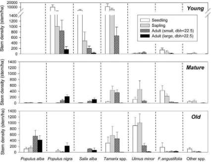
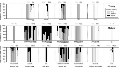
Recent Changes in the Riparian Forest of
Teks penuh
Gambar

Garis besar
Dokumen terkait
the heavy fractions, were found between present and historical forest management types (average total organic carbon (OC) stocks of mineral soil: 9.7 ± 2.3 kg m 2 ; average OC
The mangrove forest is functioning effectively reduces effects of humidity fluctuations at the sea level , so as to ensure the stability of air humidity in the mangrove
Affirmation of adat forests as state forest within territory of adat law people is defined in Article 1.. number
Soils of the East Takaka District Soils of the river floodplain and river flats Well drained Map Symbol Use Rating Takaka soils Tk, Tksh B Imperfectly to poorly drained Harihari
We use a case study of the middle Wieprza River basin to discuss the role of archaeological pre-understanding and the challenging location of sites within a fluvial landscape.. We
To test whether the presence of a riparian reserve influenced community composition we compared three groups of data: sampling points 50 or 100 m away from the river in oil palm sites
Given the potential caused by debris flows that can damage infrastructure along the Krasak River and endanger the community around the border area of the Krasak River, a study of
