-{::#;
- ,-_i"*e#iEre&-++ + -:-:;-I* *$q
. _ .-+ i.-, : -,.
-r
--I
Proceeding Book
rHE
5.hINTERNATIONAL
CONFERENCE OFJABODETABEK STUDY
FORUM
,SUSTAINABLE
M
EGACITIES
:VULNERABILIW,
DIVERSITY
AND
LIVABILITY,,
IPB
lnternational
Convention Center
(llCC)
Bogor,
lndonesia
.
17-18
March 20L5
rrI ll
rrI rl
ProceedinlThe 5th lnternational conference of Jabodetabek study Forum "Su stai nabie Megacities : Vu I ne rabi I ity, D ive rsity a nd Liva bility"
ISBN :978-502-1.M37 -7 -4
CREDIT
Crestpent Press, Bogor, lndonesia
Editor
Dr. Ernan Rustiadi Prof. Dr. Shin Muramatsu
Dr. Alinda FM Zain
Dr. Janthy T. Hidajat
Copyeditor
candraningratri Ekaputri widodo, PhD
Febri Sastiviani Putri Cantika, S.P. Novida Waskitaningsih, M.T
Layout and Cover Design
M. Nurdin
Januar Sena
First edition, April 2015
Copyright O 2015, Crestpent Press. All rights reserved'
Proceeding. The 5th lnternational Conference of Jabodetabek Study Forum
"sustainable Megacities: Vulnerability, Diversity and Livability"
Steering
Committee
-
Dr. Ernan Rustiadi (Bogor Agricultural University)-
prof. Dr. Shin Muramatsu (The University of Tokyo/Research lnstitute for Humanities and Nature)-
Prof. Dr. R. B. Singh (University of Delhi)- ilf.
Dr. Tommy Firman (Bandung lnstitute of Technology)-
Dr. Alinda FM Zain (Bogor Agricultural University)Organizing Committee:
Dr. Janthy T. Hidajat (Chairperson)
Dr. Candraningratri Ekaputri Widodo (Secretary)
Dr.
Ami
A
Meutia;
Dr.
Umar
Mansyur; Kengo Hayashi, PhDc.;Andi
SyahPutra,
M'Si';
RezkyKrisrachmansyah, M.T.; Annisa Hasanah, S.P.; Cindy Aliffla, M.Si; Febri Sastiviani Putri Cantika ,S.P';
Herwita Andriamasari, S.P, Lutfia Nursetya Fuadina, S.P.; M. Nurdin, 5.Kom.;
M.
Ridha lchsan, S.T.; M'yogie Syahbandar, S.T.; Novida Waskitaningsih, M.T.; Nusrat Nadhwatunnaja, S.P.; Yanti jayanti, S.P; Tri
Wahyuni Wulandari, Amd.; Januar Sena, Amd; M. Arifin; SaepulAmri'
5ecretariat:
Center for Regional system Analysis, Planning and Development (CRESTPENT/P4W)
Bogor Agricultural University. IPB Baranangsiang Campus, .lalan Raya Pajajaran, Bogor 16143, lndonesla
Foreword
More than half of the world's population now lives in urban areas. Rapid urbanization in Asian developlng
countries qtrer the past half century has been followed by excessive urban population concentration in
very largeilOrn uggto*erations, so called as megacities. The UN defined megacity as a metropolitan area
(urban agglomeration complex
with
more than 10 million inhabitants. The numberof
megacities in theworld has increased
flom
10 megacitiesin
1990with
153 millionof
populationor 7
percent urbanpopulation of the world
to
become 28 megacities in 2014 with 453 million populationsor
12 percenturban population of the world. The United Nations expected that by 2050 about 66 percent of the world's
population will live in cities (UN, 2014).
The rapid growth, high population density and high consumption rate of residents in megacities has led to
a wide range of local and global socioeconomic and environmental impacts which requires attention from
the global community. Therefore,
it
will significantly affect the future prosperity and sustainability of theworld. The Greater Jakarta
or
Jabodetabekis
experiencing continuous growththat
seemsto
be anunstoppable phenomenon
and
at
the
sameis
facing various problemsthat
maynot
have beenexperienced by other major cities
in the
world. The resultof
many studies showed thatthe
carryingcapacity of the environment, especially land and water in Java lsland where Jabodetabek lies, is already
overshot. However, giverr the relatively rapid grcwth of Mega Urban Jakarta, it is possible that Jakarta will
grow to be the world's largest megacity.
Amid
the
global concernon
the
negative impactsof
the
continuing megacities' growthon
global environment,the
Centerfor
Regional System Analysis Planning and Development (CRESTPENT/P4W),Bogor Agricultural University (tPB) has established Jabodetabek Study Forum since 2001. This Study Forum
has conducted biennial international seminar on complex mega-urban issues on Asian megacities as well
as urbanization and urban-rural linkages in Asian countries. The biennial conference has a tradition of
organizing two types of paper presentations, namely scientific papers and community papers This year's
cor-rference will also open a session
for
local government officials. This proceeding book covers papersfrom nearly all the presentations delivered during the conference.
We hope that this proceeding book
will
be able deliver the aims of the conference:to
recognizemulti-dimentional aspects, perspectives
and
knowledgeon
megacities,to
communicateand
facilitateexperiences, policies, and studies related
to
challengesof
continuing development of labodetabek andAsian Megacities, as well as solutions to address these challenges; and to bring up common understanding
on the development of labodetabek and Asian Megacities'
Bogor, April2015
.?
Contenl
Greeting from Chairperson of Organizing
Comittee
...3 Dr. Jonthy T. fl.idojotGreeting from the Chairman of labodetabek Study
Forum
...5 Dr. Ernon RustiodiGreeting from the Director General of Reseacrh lnstitute for Humanity and Nature (RIHN),
P rot'essor Tetsuzo Yo suno ri
Opening Remark from the Rector of Bogor Agricultural University (lPB)...8 P rofesso r H e rry Suha rdiyonto
Keynote
Speeches....
... 11Towards and lntegrated Jabodetabek
Area...
...13 Ferry Mursytdon BoldanThe Future Jakarta: Planning and
Governance...
...17Sutonto Soehodho
Asia's Megacities will Save the Earth !
-
Megacities andSustainability...
...2.1 Shin MuromotsuSustainable Asian Megacities: Emerging Urban-Rural
1andscapes...
...25 Stephen CoirnsResearch lnstitute for Humanity and Nature
(RIHN)...
... 29Study on Multi-Functionality
of
Urban Lakes (Situ and Waduk) in Jabodetabek - focused onwater purification and flood mitigation
effect
...31.Koshi Yoshido, Emiko Motsumoto, Ryunosuke Horiyo, Kenji Tonoko
Desakota, or Just a Kota? Transformation of Suburban Kompungs in
Jakarta
...40 Tsuguto Yomoshito, Kengo Hoyoshilnvolution: A Strategy of Kinship Based Living Spaces To Deal With High Density Population in
Urban Kompung A Case Study in Kompung Cikini, Jakarta,
lndonesia.
...51Meidesto Pitrio, Yuki Yoshikoto, Akiko Okobe
Determinants of Residential Satisfaction and the Role of Transport Mobility in a Developing
Megacity: Evidence from the lakarta Metropolitan Area
...
...62Ryosuke Abe, Hironori Koto
JABODETABEK Local
Government
...79Setu Front City of Cibinong Raya: An ldea for Protecting and Promoting Urban Development
in Capitalof Bogor
Regenry
...81Syoriloh Sot'ioh, Tiko M. Et'lendi, K. Sepryo Promudtto
Land-Use Cover
Change...
...99Analysis
of
Land Cover Changes lmpactto
The Runoff Coefficient and Peak Discharge inUpper Ciliwung Watershed Using Multi-Temporal
lmages...
...101Ardilo Yononto, Nuril Umom
Analysis
of
Land Use and Cover Changesln
Ciliwung and Cisadane Watershedln
Three.?
Land-Cover Changes Analysis in Ciliwung Watershed Upstream for Flood Risk Reduction...114 Anniso Hasanah, Bombong Sulisryontoro, lndung Sifti Fotimoh
Land Use Change Prediction for Spatial Planning Consistenry in Jabodetabek ...120 Diyoh Novito Kurnionti, Ernon Rustiodi
Land Use Prediction of the Development Potential and Conversion Direction of Agricultural
Land in Bogor
District...
...131Henviio Andriomosori, Wohju Q. Mugnisyoh, Aris Munondor
Delineation
of
Sustainable Paddy Field Areasin
Java CaseStudy:
Bekasi Regency andSuk*mi
Regency
...138Sigit Sontoso, Ernon Rustiadi, Eudi Mulyonto, Kukuh Murtiloksono, Widiotmoko, Noer Fouzi Rochman Peri-Urban Agriculture Dynamics and lts lmpact on Run Offand Soil
[rosion
in JabodetabekMetropolitan
Area...
...1,47Didit Okto Pribodi, Derek Vollmer
Spatial Modelling for Prediction of Built Up Area Development Using Land Change Modeler
Analysis and Land Potential lndex Approach (Case Study Bogor
City)...
...155 Zidni Forhati Silmi, Sri Lestori, Lintong Dwi CondroSpatial Planning Audit of Tugu Utara Village and Tugu Selatan Village, Puncak Area, Bogor
Lutfia Nursetyo Fuodina, Ernon Rustiodi, Lo Ode Syomsul lmon
Spatial Prediction for Build Area lncreasing in Suburban Bogor by Using Cellular Automata ...713 Dvri Sonty Ratnosori ond Puspo Kusumowordoni
Spatio-Temporal Land Use and Cover Change Analysis in Southern Region
of
West Java'sWatersheds
...182thre Wijoyo Aroengbinong ond Koswonto
Understanding Self-Organization, Urban Transformation, and The Spatial Planning System in
Greater Jakarta Area, lndonesia
...
... ...188Yovi Dz ulhijjah R o h m ow oti
Urban
Diversity...
...2C7Significance
of
Betawi Pekarangan as Culturalldentity
Towards Developmentof
MegacityPronowita Korina Nursyirwon, Wohju Q Mugnisjoh, Nurhoyoti H S Arilin
ThePerilsofTourismGrowthinAWorldHeritageSite: TheCaseof GeorgeTown,Penang...2L4
Badaruddin Mohomed, Shido lrwono Omor, Siti Zuloiho Zoinol Abidin
The Use
of
Satellite lmagery Analysisfor
ldentifying Gentrification Phenomenon: A CaseStudy of Tembalang, A Suburb of Semarang City...
...
...224lmom Buchori, Pongi
Community and
Vulnerability...
....235Dialectic of Modernity, Spatial Articulation, Capitalism, and Rationalization of Action of Local
Community (Case Study in The Fringe Area
of
Daya Sub-District and Surrounding Areas,Makassar City)...
..
..,...231Sotaro Suryc
Residential Area in Suburban lndonesia Today: Conflicts and the New Pattern of Residential
Seg regat io n . 251
Pitri Yondri
Role
of
Communityin
Urban Forest Management: Case Studyof
Sangga 8uana, SouthKurnio i,lovionti. Angqo Sisca Rohodion
Small Step toward Wet Organic Waste Management at The Community Level in
8o9or
...277Dormcno Tonrwiryono
The Community Building Codes in High Density Slum Settlement...
..
. .... ... 281The Role of Public Space lmprovement for Enhancing Citizen Happiness Study Case: Bandung
Meta lndriyoni Kurniosori, Hanfie Vondonu, Karimo Nodya Putri Soefulloh
Vulnerability and Adaptability of Traditional Community in Facing
of
Disaster (Case Study:Naga Village in Tasikmalaya
District)
...310lndarti Komalo Dewi
The Climate Change Adaptation and Disaster Risk
Reduction...
... 319Application of Weather Modification Technology for Flood Mitigation in DKI Jakarta...327
|rdilo
Yononto, lbnu Athoilloh, Budi HorsoyoClimate Vulnerability in the Area of Jakarta, Depok and
Bogor...
...332Armi Susondi, Momod Tamomodin, Sout Sogalo, Dodon
Coastal Hydrodynamics and Sedimentation Study of The Jakarta Giant Sea Wa11...338 Velly Asvoliontino, A. Eogyo Widogdo, Widjo Konqko
''7
Coastal Flood in North Jakarta:
Damage Estimation and Adaptation Strategy Due to ClimateAndrion lrwonsyoh, Eko lnton Kumolo Putri, Sahot Simonjuntok
Participation
of
Local Communitiesand
Civil SocietyOrganizations
on
Coping LandSubsidence in
Jakarta
...353Erlis Soputro
Potency of Climate-Related Disasters in The Area of .Iakarta, Bogor and Depok Based on The
Rainfall
Prediction
...370Armi Susondi, Momod Tomomodin
Responding to Changing in Climate: Who act the most in Greater
Jakarta?
...377Syorifoh Aini Dolimunthe, lnton Adhi Perdona Putri
Side Scan Sonar Application
for
Surficial
SedimentCharacterization
and
GeologicalInterpretation at Eastern Jakarta
8ay...
...385Tout'on Wiguno
The Alternative Optimalisation Land Use Planning and Agrotechnology
to
Develop WaterResources at Mahat Hulu
Watershed...
...390Firmon
Hidoyot
'The Use
of
Precast Concrete Systemin
Road and Bridge lnfrastructure as Technologicallnnovation Towards To Green
lnfrastructure...
...401Pingkon Nuryonti
Energy lssues in Spatial
Planning...
.... 409Toward Energy Planning in Jakarta: The Potential Role of Provincial Government... ... ...411
Nusoibo Adzillo, Tesso Tolitho, Delik Hudaloh
lnfrastructure and
Transportation...
...425A
Dynamic Modelof
Environmentally Sustainable Transport:A
Case Studyof
MegacityAhyahudin Sodri, lwo Gorniwo, Roldi Xoestoer
ICT and lt's Role on Transportation Problems Case of Jakarta-Bekasi, lndonesia...
...
...431Rini Rochmawoti, Silvio Shelly Adelino
Management Strategies
of
Public Transportation Systemsin
Bandung Metropolitan Area(BMA): lnstitutional Point of
View...
...444Nondi
Seeking Paths for Transit-Oriented Development in
Jakarta:
Local Perception onStation-Area
Development...
....
. .455Condraningrotri f koputri Widodo, Tetsuo Kidokoro, Tokoshi Onishi
Sustainable Transportation Management for Non-Bus Public Passenger Transport (Angkot) in
Eogor
City
....
....414Globalization, Formal Economy and lnformal
Economy..
...493Foreign Dlrest Investment and Regional Dvelopment in Jakarta Metropolitan Area ...495 Silvonio Dwi Utomi
Linking The Urban Young Middle Class and Megacities Malls in Greater
Jakarta
...506lnton Adhi Perdano Putri, Andini Desito Ekoputri, Vondo Ningrum
Supermarket Pekarangan: Centre
of
Local Agricultural Productsin
Orderto
Advance Economics and Bring Society to Loves Local AgricultureProdusts...
...513 Ade Brion Mustofo ond Sorliyonti S.Planning
,nilor"rnrnce...
...521Analysis Development Of Border Areas ln Kapuas Hulu Regency (Development lndex (bosed on the ovoiloble focilities ond infrostructures) and
Economic)
...523M. Yogie S, Atong Suiondi, Muhomod Ardionsyoh
. _pncept of Tourism Development Strategy in Semarang
Municipality
...531Roy Mcrch Syohodot, Priombudi Trie Putro, Pronowito Korino Nursyirwon, Rizki Alfion, Moh. Sonjivo Ret'i Hosibuan
Factor Determining The Success of Metropolitan lnstitution:An experience from 8KSP...539 Citro Fodhiloh Utomi, lko Puspito Poncowoti
ldentification
of
lnstitutional Condition in Urban Fringe Settlement Area of Jabodetabek toAddress the Degradation of Environment and lnstitutional Fragmentation using lnterpretive
StructuralModelling....
...546lonthy Trilusionthy Hidojot, Sontun R-P. Sitorus, Ernan Rustiodi, Mochlud
Policy Approach
in
Technopoles Developmentas The
Future
Region:
Case StudyTechnopoles in
Peka|ongan...
...555A.Husni Y. Rosodi
Study on Urban Settlement Management in The Central Part of Central Ciliwung Watershed,
Prito lndoh Protiwi, Deboro Eudiyono
The ldentification of Tourist Destination in Jakarta That Related to The Promotion Program,
Moda and Transportation
System
...580Priyend i swo ro Ag usti no Be lo
The Politics of and Leadership in Metropolitan Governance: The Case of Jakarta, lndonesia ...595 Eokti Setiowon
Green City, Green Development and Ecosystem
Service..
...503Availibility of Green Open Space Analysis
to
Create a Sustainable Green City Area in BekasiUsing Remote Sensing
Techniques
...605 Corolino Ajeng Sukmowoti Putri, Nurwidyo Amborwoti, ond Olgo Ayu DewantoriCiliwung Botanical Garden :Restoration of Upstream Ciliwung Based on Agrotourism... ...609 Syoh Devo Ammurobi, Hafizh Abdul Aziz, Kortikasari
Ciliwung River Planning as Green Corridor to Rejuvenate The River for Sustainable Urban Life
(Study Case: Settlements in Lebak Kantin, Sempur-Bogor) ..
...
...614Ri z ky Ro ho d io n R o m d ho ny
Composition of Aquatic Plant and Riparian Vegetation in Several Urban Lakes in Megacity
Rtky Kurnrowon, Cynthio hienny, Ami Meutia
Diversity of Tree Species: A Silver Bullet for Greener Megacities in Java, lndonesia .... ... ....632
Andini Desita tkoputri, lsmoyodi Samsoedin
Dynamics Model of Low Carbon City by Green Building lmplementation ..
...
...640 Mesi Shinto Dewi. Setyo 5. MoerstdikEcologicalApproach for Urban Design in Ciliwung Riparian,
8ogor...
.... ... .650Presti Amelrcwoii, Anggi Mordiyonto
Icological Landscape and House Models at Ciliwung River Side Settlement, Bogor City...659
Greenery and Blue Open Spaces Management in Water Sensitive Cities of Jabodetabek...-..671
Hodi Susilo Arifin, Kaswanto, Nurhoyoti HS Arifin
Native Trees lmprove The Quality
of
Urban Green openspace...
...683 Toti BudiortiPotential of City Parks in Reducing Urban
Pollutants...
...688Rino Dwico Desyono, Emy Junoton Muokhor, Priombudi Trie Putro
Urban Aesthetic Concept Through Structuring
of
Landscape Road Element For ldentity ofSustainable City Case Study: lntersection
of
Bank lndonesiaRoundabout and
HotellndSesia
Roundabout
"""""""'695
Yusi Febrioni ond DoisY Rodnowoti
Urban Resilience : Roadmap Towards Jakarta as Green Metropolis in
2050
"""""'lO4
Rulyon Ali Porinduti
Appendix: Conference
Pictures
""""""727
Greenery
and
Blue Open SpacesManagement
in
Water
Sensitive Cities of JabodetabekHadi Susilo Arifinl), Kaswanto2), Nurhayati HS Arifin3l t)Heod
ol Londscope Monogement Loborotory, Department of Londxape Architecture, Bogor Agriculturol University 'iLandscope Monogement Loborotory, Department of Landscope Architecture, Bogor Agriculturol tJniversity 3tLondscope
Manogement Loborotory, Deportment of Londscope Architecture, Bogor Agriculturo! lJniversiry
hsorifin @ i ob.oc.i d ; ko [email protected]: nuro rif @ iob.oc.id
ABSTRACT
Jakarta-Bogor-O"Ool-rrngerang-Bekasi (Jabodetabek),
as
a
megacityhas
highlygrowth
of
citizenpopulation.
Udan
density has been increased progressively. However, infrastructure development is leftseveral steps behind. Therefore, environmental degradation, such as urban heat, water extreme and
vulnerabilities are held not only in Jakarta, but also in its vicinity. lt's proposed
to
establish two dams inCiawi and Genteng with 36.106 m3 and 25.106 m3 water capacities
to
regulate water debit of Ciliwungand Cisadane rlvers, respectively. Due
to
some ecologically and socio-economically constraints, damconstruction has been delayed. This paper tells some lesson learned regarding greenery and blue open
space management in water sensitive cities of Jabodetabek. Case study was conducted in the scale of
Ciliwurtg Watershed as bioregional. Greenery and blue open space researches are concerned
to
theupper, the middle and the down streams of Ciliwung watershed management. According to the research
results, it's
well
knownthat
land use and land cover are increasingly changingin
Ciliwung watershedduring the latest 30 years. ln order
to
reduce risk of flooding, some alternatives are recommended tomanage greenery and blue open spaces better in the scale of rlparian landscape of Ciliwung. The upper
stream
is
projectedto
developurban
agriculture zone,the
middle
streamfor
agro-biodiversityconservation zone, and
the
downstreamfor
productive landscape zoneof
individualor
communitygardens, such as pekarangan, kebun campuran and talun. As substitution
of
big dams,it's
planned tomaking a lot of ponds and water cascade as small water retention along the river, i.e. situ, embung, danau
etc. Simple simulation could be calculated. Seventy percent
of
777 km Ciliwung river length (c.a.80 km)will be utilized for the project area. Each 1 km distance would be establlshed two ponds in the right and
the
left
sideof
public good riparian landscape. Average sizeof
pond is 50m x 20m x 2m (2.103 m3).Therefore,
total
160 ponds will regulate 32.10 m3. Those water retention ponds could be designed aslandscape services
for
recreation parks, fishing, irrigation, biodiversity conservation, micro-climateamelioration depend on the needs of surrounding communities and governments policies. ln the case of
Ciliwung River, those greenery and blue open spaces must be managed by local government
of
BogorDistrict, Eogor City, Depok City, and Metropolitan Jakarta, respectively based on administrative region.
Kewords: community gordens, embung, pekorongon, riporian londscope, situ, wotershed
INTRODUCTION
One of the main environmental problems in lndonesia cities is water, whether quality or quantity. As a
megacity, Jakarta-Bogor-Depok-Tangerang-Bekasi (Jabodetabek) has highly growth of citizen population.
Jakarta, itself known as the Special Capital Region of Jakarta "Daerah Khusus lbu Kota Jakarta" is one of
the
most populous urban accumulationsin the
world. Basedon
BPS data (December 2012) Jakartapopulation were 9,761,,407. Urban density has been increased progressively. However, infrastructure
development is
left
several steps behind. Urban carrying capacities have not estimated. yet. Therefore,environmental degradation, such as urban heat, water extreme and vulnerabilities are held not onty in
Jakarta, but also in its vicinity.
Jakarta, when it was known as Batavia in the colonial era, was built as a water front city in 1517' Based on
the history, Jakarta had got flooding in 1521, 1554, 1873 and 1918. ln the latest
34
decades, Jakarta wasflooded in 1979, 1996, 1999, 2002,2007 ,2013,2014, and 2015. lt has been known that floods account for
more losses than any other natural disaster in Jakarta both
in
termsof
lossof
lives and damage toproperty and crops. The trend in flood as natural disaster in the world from 1900
to
2008 shows thepeople affected and loss in USD and fatalities total (Fig. 1.). Meanwhile, Asia accounts for >45 percent of
water related disaster facilities and >90 percent of the affected population between 1989 and 2006 (Fig'
2). Asia
pollous
megacities, included Jakarta, located atthe
bankof
river and/orin
a coast' are noexception in terms of being wlnerable to the impending flood-related disasters 1'
Year
Figure 1. Global Natural Disaster Trend in Flood from 1900 to 2008'
Fatahtes p€{cenl rat,o rAsa (a5.6I rAhirx (6a.1) . Arneri:as (7.6) r Europe (0.4) r Oceans (0.3)
Afi€cled peopl€ psrcent talo
rAsra (90)
: Atrix (6)
E ArDer(3s {3)
. Europe (1 )
[image:12.595.27.572.27.670.2]r Ocean8 (0)
Figure 2. The ration o1 u731s1-related fatalities and people affected from 1980 to 20061
Research
of
,.Green and Bluewater
Availability Analysison
Sustainable Landscape Management inCiliwung watershed" was started under budgered by BOPTN (2013-2014)' Micro scale research in some
flooded area in Jakarta has been studied by research collaboration between IPB and ETH Singapore in the
scheme
of
,,Future cities Laboratory". Dissemination and social engineering has been implementedthrough the join research between IPB and Monash University Australia. The theme is "water Sensitive
Cities,, under managed by
the
Australia and lndonesia Centre (AlC) and Directorate General HigherEducation (DGHE). Therefore, this paper shows
the
latest 3 years research of greenery and blue openspaces management in Jabodetabek. The objectives of this paper are: 1' To show the land cover/land uses
changing
from
the
upper-the middle-the downstreamin
Ciliwungwatershed;2' To
showhow
theo
,?j
.g -9
oa
c 6 o
=6 o
o-landscape riparian
to
be managedto
achieve sustainable productive landscape; and 3. To disseminateresearch results through social engineering.
METHODOLOGY
lntensive observation was conducted
in
the
bioregionalunit
of
Ciliwung watershedfrom
the
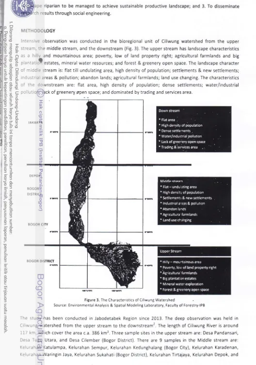
upperstream, the middle stream, and the downstream (Fig. 3). The upper stream has landscape characteristics
as
a
hillland
mountainous area; poverty, lowof
land property right; agricultural farmlands and bigplantatiJiestates, minerat water resources; and forest & greenery open space. The landscape character
of mlddle stream is: flat
till
undulating area, high density of population; settlements & new settlements;industrial areas & pol.lution; abandon lands; agricultural farmlands; land use changing. The characteristics
of the
downstreamare:
flat
area, high densityof
population; dense settlements; water/industrialpollution; lack of greenery,spen space; and dominated by trading and services area.
JAI(ARTA
DEPOX
BOGOR DISTRICT
BOGOR CITY
BOGOR DISTRICT a!M
Figure 3. The Characteristics of Ciliwung Watershed
Source: Environmental Analysis & Spatral Modeling Laboratory, Faculty of Forestry-lPB
The study has been conducted in Jabodetabek Region srnce 2013. The deep observation was held in
Ciliwung watershed from the upper stream to the downstream2. The length of Ciliwung River is around
117 km, which cover the area c.a.386 km2. Three sample sites in the upper stream are: Desa Pandansari,
Desa Tugu Utara, and Desa Cilember (Bogor District). There are
9
samples inthe
Middle stream are:Kelurahan Katulampa, Kelurahan Sempur, Kelurahan Kedunghalang (Bogor City), Kelurahan Karadenan,
[image:13.595.35.563.23.775.2]PEIALffAI PAaa,fiux
O'#----:-'-t-l olscrrf - to-Prgr [-1 ear***
Kelurahan pondok cina (Depok City). The downstream study sites are tocated in Metropolitan
Jakarta, i.e.
Kelurahan Lenteng Agung; Kelurahan Kampung Melayu; and Kelurahan Tanjung Priok (Fig'4)'
\
I3=
[image:14.595.38.570.6.824.2]'*
Figure 4. Study area in Ciliwung Watershed
The macro scale research of green and blue land cover/open spaces changing was conducted in
the level
of bioregional of ciliwung watershed from 197& 1995, and 2010'
lt
was detected using remotesensing
methods with the supervised classification. To know the changes in land cover' it's used Landsat Mss
in
1978, Landsat TM 1995 and Landsat ETM + 20103' Survey method was held in order to
collect
bio-physic-social-economicdatainthemicroscaleof"kelurahan"unit'FocusGroupDiscuSsiOnwithallstakeholders was conducted
to
decide dissemination program media (leaflet, poster/standing banner, and pocketbook). Those media will be used for social engineering to change the mind-set of communities' who are
living close to the riparian landscape'
RESULT AND DSICUSSION
Green and Blue Open Spaces Management
Greenery open spaces and blue open spaces are very important
for
landscape services' especialiy forwaterresourcesmanaSement.Theyarealsofunctionedasbiodiversityconservation,microclimate ameliorationbyCarbonsequestration,andlandscapebeautification'TheformofgreeneryopenSpace can
be
as pekorangonor
home garden, agriculture landscape, orchard, mixed garden,plantation,
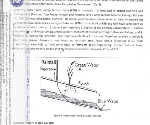
Community Park, City Park, and urban fOrest. Vegetation as land cover can absorb and keep water
in the
soil. A process of evapotranspiration, which produce water in the air' is called "green
water''
Blue openspaces could be found as water bodies (lotic and lentic) of river' canal' situ' embung' lake' dam' pond and
the water penetrated
to
the soil, then percolated to the aquifer layer. Both of surface water and springwhich is exposed as water bodies then it's called as ,,blue wate/, (Fig. 5).
Greenery open space, ruong terbuko hijou (RTH)
in
lndonesia has regulatedin
spatial planning andmanagement lRencano Tata Ruong Wilayoh ond Rencano Tato Ruong Kota/Kobuporen) through the Law
No. 26/2007 regarding Spatial Planninga. However, policy/decision makers have not been interested yet
to
regulate blue open spaces, ruang terbuko biru (RTB) strictly. Both of RTB and RTH have some roles aslandscape services, such as: 1. water basin reservoir; 2. habitat
of
bio{iversity conservation;3. carbonsequestratin and micro-climate amelioration; 4. medium for production of agriculture and fishery; and 5.
Medium
for
serving the amenities, landscape beautiflcation for tourism. Therefore, analysis of green &blue open
spaces changesis
very
importantin
study area. Focus Group Discussion (FGD) with stakeholders were heldto
have some inputto
formulate social engineering. The lastbut not
least,dissemination program to be designed for implementation of sustainabte RTH and RTB.
Rainfall
Green
Water
A
I
Etaporadon
Runof
Blue
Water
Figure 5. Green water and blue water concept
Changing Pattern of RTB and RTH
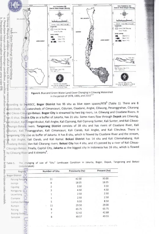
Land cover changing, especially, the RTB landscape in Ciliwung watershed from 1978, 1995, and 2010 was
detected by using remote sensing methods with the supervised classification. To identify the changes in
land cover, it's used Landsat MSS in 197g, Landsat TM 1995 and Landsat ETM + 20103. spatial analysis
result showed significant changes when RTB area in 1978-1995 was decreased approximately 27.62 ha
(0.07%')and 1995 to 2010 declined approximately 56.01 ha (0.77%). The change directions are dominated
by changes RTB
into
settlementsof
a
new townwith
an areaol
1.74.79 ha (16.96%). Furthermore,greenery open space (RTH) was changed in Ciliwung watershed from 1978, 1995
to
2010 significantlyr a [image:15.595.23.545.34.471.2]' ?::l] l€:"]!!t j,:je-*l_ Lcaffi:
f,f r*:<:a.4 -ri ?is oE !G-e
X -sr.f::, 9.* ia''r': fl:>s';1
--/
,
re1!.L**n=:_
-_nc-)<:43q'::
bi {_.;.:.r.;.4 '7.:.)yl- l9r1rt6ry '?-r-d' rr!_i_..iBb5'ks.ar l4 J
Figure 6. Blue and Green Water Land Cover Changing inCiliwung Watershed
in the period of 1978, 1995, and 20103 o
According
to
BBWSCC, BogorDistrict
has 95situ
as blue open spaces/RTBs (Table 1). There are 8watersheds, i.e. watersheds of Cimanceuri, Cidurian, Cisadane, Angke, Ciliwung, Pesanggrahan, Cikarang
and Cikeas-Cileungsi-Bekasi. Bogor City is streamed by two big rivers, i.e. Ciliwung and Cisadane Rivers' lt
has 6 situs. Depok City as a buffer of Jakarta, has 21 situ. Some rivers flow through Depok are Ciliwung,
KaliKrukut, Kali Grogol-Krukut, Kali Angke, KaliCipinang, Kali Cipinang-Sunter, Kali Sunter, and Kali
Cikeas-Cileungsi-Bekasi rivers. Tangerang District consists
of
38 situ and has riversof
Cisadane River, KaliCidurian, Kali pesanggrahan, Kali Cimanceuri, Kali Ciarab, Kali Angke,
and
Kali Cileuleus. There isTangerang City also as buffer of Jakarta.
lt
has 8 situ, which is flowed by Cisadane River and the stream,i.e. Kali Angke, Kali Ciarab, and Kali Kamal. Bekasi District has 14 situ and Kali Cllemahabang, Kali Cisadang-Bekasi, dan Kali Cikarang rivers. Bekasi City has 4 situ, and it's passed by a river of Kali
Cikeas-Cileungsi-Bekasi. Finally, Capital City, Jakarta as the biggest city in lndonesia has 16 situ, which is flowed
by Ciliwung River and it streams6.
Table
1.
The changingof
sizeof
-Situ" Landscape Condition in Jakarta, Bogor, Depok, Tangerang and Bekasi(Ja bodetabek)
Region Number of Situ Previouslv (ha) Present (ha)
I :srjr: €- itu r@f
l** :* rs-.
Bogor District
Parung Panjang
Jasinga Cigudeg
Na nBgu ng
Leuwiliang
Ciampea
Ciomas Darmaga Rumpin
Pa rung
Bojong Gede
Semplak 11 o 2 3 1 1 5 11 9 7 6 42.00 18,05 3.50 4.50 I (n 2.50 9.50 29.50 65.75 52 42 49.57
30.00
18 05 3.50 4.50
2 .50 2.s0
8s0
29.00
65 75
42 88
[image:16.595.31.569.18.810.2]ecosystems. The data were analyzed by classification of horizontal ardvertical
diversity of plant, Shannon
lndex and lmportant Value lndex. Based on the resurt, pekorongon
rrd
forest garden in the top part ofthe middle stream of ciliwung River had
the
hiShest scorefor
diversity (4'45 and 3'9)' But' themixed
gardenhadthehighestscoreinthemiddlepart(3,68).Goodspeciesthatmustbekeptandplantedon
riparian based
on
important valueindex
areZeo
moys' Ceiba pefiondro andFicus e/osticos' Those
ecosystemsaresuitableforagro-biodiversityconservationdevelopmmt(Fic.7).
The downstream study sites are Kelurahan Lenteng Agung; Kelurahan Kampung Melayu; and
Kelurahan
Tanjung Priok. They are located
in the
alluvial floodof
Metropolitan Jakarta Therefore'landscape
management
for
green andblue
open spacesare
addressedto
become productivelandscape as
community gardens,
e.g.
pekoronganlpubltc pekorongon (home gardens/apartmentgardens), kebun
compuron(mixed gardens), and kebun tolun (forest gardens) is depended of the
community needs and
government poliry and decisions. As the rules, riparian landscape should be free from the built up
and
constructed building. Paradigm
of
riverfront
landscape must be implementedthrough re-movement of
slum landed house
to
multi-storey housing (Fig' 8)' Replacement of green openspaces as community
gardens in the riparian is very necessarylo'
:=-tu
.?
Figure 8. ,qnticipative landscape model in alluvial flood riparian landscape:
normal water surface (top), the 3'd early warning (mid), and it's getting flood (bottom) conditionl0.
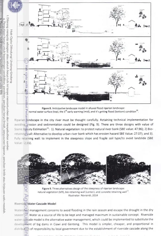
Riparian landscape in the city river must be thought carefully. Retaining technical implementation for
avoiding erosion and sedimentation could be designed (Fig.9). There are three designs with value of
Scenic Eeauty Estimationll: 1). Naturalvegetation: to protect natural river bank (SBE value: 47.961;2)
Bio-retaining wall: Alternative to develop urban river bank which has eroslon hazard SBE Value: 27.07); and 3).
Fully retaining wall:
to
implement in the steepness slope and fragile soiltype/to
avoid landslide (SBEValue: -2,65).
Figure 9. Three alternatives design of the steepness of riparian landscape:
natural vegetation (left), bio-retaining wall (center), and concrete retainrng wall:i. lllustrator: Novia ndi, 201.4
Riverside Water Cascade Model
Watershed management concerns to avoid flooding in the rain season and escape the drought in the dry
season"'.
Wate, as a source of life to be kept and managed maximum in sustainable concept. Riversidewater cascade model is the alternative water management, which could be implemented to substitute the
development
of
big dams in Ciawi and Genteng. This model is simpler, cheaper, and proportional in [image:18.595.33.556.18.782.2]riparian landscape. By the rule, the riparian is belonging to public own or government bnd. By simulation
(Fig. 10 and Fig 11),
it
is assumed that only 70 percentof
117 km Ciliwung river length can be used forconstruction of riverside cascade. C.a. 82 km is suitable. Riverside water cascade will be buih in each km
of both sides in the left and right. 1.64 water ponds will be confirmed, which the size of 5O m length, 25 m
width and
5
m
depth.
One pond has 5,250 m3 water volumes. Therefore,the total
water can bepreserved around 1,025 million m3
or
1,025billion
liters. Asa
productive landscape, riverside watercascade provides water for irrigation, fishery, habitat of wildlife biodiversity conservation, micro-climate
amelioration,Sd recreation object for the communities2' 12.
1l
.rIi
si:
=CASCADE
'j1
; , lr-, -" . i: : ,- t-._ i':_': .
1km
Down stream
More suilable
. i:,
Assumption
For 1
riverside
.,
?
cascadeLength 50 m
Width
25
mDepth
5 m50
:-
Volumeper
1'g
riverside
cascade+A25Om3 There are 2
ponds
riverside
cascade per km (left & riqht)Volume
per km (2 ponds) 6,250m3x
2=
12,500
m'/
kmUp stream Enhance
the
meander'.:.i
Figure 10. Rive. water cascade model for blue open space landscape managementts
llustrator: Noviandi, 2014
Middle
streamMore suitable
i,lot surtab,e fcr riwrsirJe ces.ade
117 km
82 km
Figure 11. The effective landscape for riverside water cascade in Ciliwung ripariants
lllustrator: Noviandi, 2014
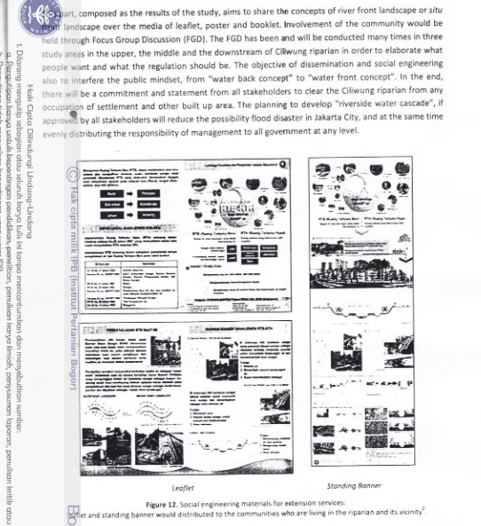
[image:19.595.39.579.73.821.2]This part, composed as the results of the study, aims to share the concepts of river front landscape or situ
front landscape over the media
of
leaflet, poster and booklet. lnvolvement of the community would beheld through Focus Group Discussion (FGD). The FGD has been and will be conducted many times in three
study areas in the upper, the middle and the downstream of Ci[wung riparian in order to elaborate what
people want and what the regulation should be. The objective
of
dissemination and social engineeringalso
to
interfere the public mindset,from
"water back concept"to
"waterfront
concept". ln the end,there will be a commitment and statement from all stakeholders
to
clear the Ciliwung riparian from anyoccuoation of settlement and other built up area. The planning
to
develop "riverside water cascade", if,Orrouil
by all stakeholders will reduce the possibility flood disaster in Jakarta City, and at the same timeevenly distributing the responsibility of management to all government at any level'
--+-.r-a---*F
f+EI
EI+
IEEI
E+E
,,sBrr=e*{€*l
-EbE@-- |HU---**--*a-a *6q5*FE +--hbE--*
n64!-k frbtl-i&xFa
-=:E-EEE
=
EilEEI
Er
a€ric
ffiffi
*--dE---* -.--rE*--b==#===:
ni'.rj-"-
=--:{._
,1:i
[image:20.595.36.578.18.611.2]Leoflet Stonding Bonner
Figure 12. Social engineering materials for extension seryices:
leaflet and standing banner would distributed to the communities who are living in the riparian and its vicinrty2
CONCLUSION
Based on
the
characteristicsof
the
riparian landscape along Ciliwung River,the
proposed landscapemanagement types are: urban agriculture
in
the
upper stream, agro-biodiversity conservation in themiddle stream, and community gardens in the downstream. The regulation that the riparian landscape
should be public green open space should be strongly implementeC. To slow down the river flow and to
utilized more effectively and efficiently the water resources, the n'odel
of
water cascade, canalization, and small check dam are suggestedto
be developed intermittently along ihe river, where the landscape ismanagement in riparian landscape, and the recommendation of landscape management and alternatives
models
to
manage blue open space, were simply explainedin
communication media such as leaflet,poster and video. These media wil! be utilized as community guidance for social engineering. This effort
should be supported by local government to convince the people welfare.
ACKNOWLEDGEMENT
This research
w5
supported by 2O73-2OL4|BOPIN-IPB/DGHE research entitled "Green and Blue WaterAvailability Anallsis on Sustainable Landscape Management in Ciliwung Watershed" and Future Cities
Laboratory-Landscape Ecology
in
Ciliwung River, Puncak-8ogor-Jakarta (ETH Zurich-NUSSingapore-Faperta IPB). And also as the collaboration research of Promoting lnnovative Solutions on Water Related
Problems in the Water Sensitive Jakarta Megacity
-
IPB/DlKTl & Monash Univ./Australia lndonesia Centre.And many thanks for the assistance from supporting researcher of master students:.Azkham HS, Erlinda
Faradilla,
Tri
Utomo Zelan Noviandi;and
bachelor students:Morita
Ayuningtyas Saii,- Novy GitaniSiswanto, Aftian Tyo Saputra, and Aliifah Ghassani.
REFERENCES
t1l
Adikari Y, Osti R, Noro T: Flood-related disaster vulnerability: an impending crisis of megacities in Asia. J of Fbod Risk Management 2010, 3:185-91.t2l
Arifin HS, Kaswanto, Arifin NHS: fulonojemen Lonskop Riporion SunToi Ciliwung Eerbosis Pemberdoyoon Mosyorokot dolom Mengotosi Bonjir di Wiloyoh Hill(Management of Riparian Landscape of Ciliwung River Based on Community Empowerment to Overcome Flood Disaster in the Downstream). Seminar Hasil-hasil Penelitian PPM IPB Desember 1-3,2014. Hotel Pajajar.an Suites Resort & Convention, Bogor Nirwana Residence, Bogor (in Bahasa lndonesia),2074.
l3l
Arkham HS, Arifin HS, Kaswanto: Management of Blue Open Space Landscape in Ciliwung Watershed. Graduate School Seminar of Landscape Architecture Department, Bogor Agricultural University (in Bahasa lndonesia). Bogor, 2014.t4]
Arifin HS: Revitalisasi Ruang Terbuka Biru (RTB) sebagai Upaya Manajemen Lanskap pada Skala Bio-Regional JRisalah Kebijakan Pertanian dan Lingkunga n 2014, 1:172-80.
t51
[BBWSCC]: lnventorisosi Eodon Air Jobodetobek (lnventory of Water Catchment in jabodetabek]: Balai Eesar Wilayah Sungai Ciliwung Cisadane, Departemen Pekerjaan Umum. Jakarta (in Bahasa lndonesia), 2011.t6l
Noviandi TUZ: tnventory of Blue Open Space in Jabodetabek. Bogor: Laporan Topik Khusus Manajemen Lanskap Riparian - Task 1. Graduate School of Bogor Agricultural University (lPB) 8ogor. 2Lp (Unpublished\.2015.t7l
Siswanto NG, Arifin.HS: Green and Blue Open Spaces Management for Potential Revitalization and DevelopmentUrban Agriculture in the Upper Stream of Ciliwung River. Undergraduate Seminar of Landscape Architecture Department, Faculty of Agriculture, Bogor Agricultural University (in Bahasa lndonesia), 2014. p. 10.
t8l
Sari MA, Arifin HS: The Dynamic of Plant Strusture in Riparian Landscape of the Middle Stream of Ciliwung River' Undergraduate Seminar of Landscape Architecture Department, Faculty of Agriculture, Bogor Agricultural University(in Bahasa lndonesia),2014. p. 1"0.
t9l
Saputra AP, Arifin HS: Riparian Landscape Management for Community Garden in the Downstream of CiliwungRiver. Undergraduate Seminar of Landscape Architecture Department, Faculty of Agriculture, Bogor Agricultural University (in Bahasa lndonesia), 2014. p. 10.
tlol
Qing W, Ying F, Risinda N, Susetyo B, Ziegler M, Olas K: Facing the River. Singapore: The Future Cities LaboratoryWorkshop in Jakarta and Singapore, 2013.
t11l
Noviandi TUZ, Mansyur A, Nurwanda A, Danniswari D, Franjaya EE, P FDl, Mulya MR, H NJ, Najmi N, Rejoni R,Wakyudi: Kajian Strategi Pengelolaan Ruang Terbuka Biru (RTB) Kota Bogor (Analysis StrategY of Blue Open Space
Management in Bogor City). Workshop Pengelolaan Kota Bogor, Mata Kuliah Pengelolan Lanskap Berkelan.iutan (ARLs21) Semester Genap TA 2073/2014. Bogor (in Bahasa lndonesia), 2014'
t12l
Arifin HS: Manajemen RuangTerbuka Biru (RTB) untuk Pengendali Banjir. Majalah lndonesiaHousing,2014.pp.42-5.
Arifin HS: Green and Blue Open Spaces Management in Water Sensitive City of Jakarta. lnternational Workshop of lnfrastructure Cluster. the Australia lndonesia Centre in Melbourne,20l5.
0rganized
byCo-orqanrz
&
a4: Erg
ed br Sponsored by