isprsannals II 2 W1 13 2013
Teks penuh
Gambar
Garis besar
Dokumen terkait
The graph shown in Figure 11 shows two types of 3D spatial data sets used in the single object search: CityGML data and 3D spa- tial data with space-filling curve implementation..
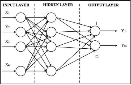
Considering specific metadata about 3D geospatial models, the proposed metadata-set has six additional classes on geometric dimension, level of detail, geometric modeling,
In this paper, we discuss an approach to realise two operators named ’overlap’ and ’meet’ between two 3D planar polygons, using Oracle Spatial operators SDO ANYINTERACT (3D) and
As shown in figure 5, V-world framework is composed of five service and system sectors that are portal service (service support, open API request, 3D map searching,
By generating image tiles using this service, the 3D rendering process is shifted from the client side, which provides major advantages: (a) The complexity of the 3D city model data
From the concepts presented, the requirements for the unified spatial data model: are to construct a 3D geometry capable of representing regular objects (such
The actual data model implies that interior components of a building have only one (geometrically exact) representation, and that the building ’s interior can only be represented
3D city models based on such standards are increasingly used by engineers and urban planners in the environmental and energy sector. Previously 2D, spatial data
