DEVELOPMENT
ASSESSMENT UNIT
Tuesday, 13 October 2020
T O S T R I V E F O R B E T T E R T H I N G S
DEVELOPMENT ASSESSMENT UNIT MEETING 13 OCTOBER, 2020
ITEM SUBJECT PAGE
ITEM-1 CONFIRMATION OF MINUTES
ITEM-2 DA 1616/2020/HA - INSTALLATION OF A TELECOMMUNICATIONS FACILITY (MOBILE PHONE BASE STATION) - LOT 1 DP 402457, NO. 43 CATTAI RIDGE ROAD GLENORIE
6
ITEM-3 DAU REPORT - DA 1135/2020/HA - DETACHED SECONDARY DWELLING PURSUANT TO SEPP AFFORDABLE RENTAL HOUSING 2009 - LOT 32 DP 227396, 5 GREGORY AVENUE, BAULKHAM HILLS
32
ITEM-4 1270/2020/HC – DELETION OF RESIDENTIAL UNITS IN BLOCK F2 AND REPLACEMENT WITH A CHILD CARE CENTRE, INDOOR RECREATION FACILITY, SHOPS AND ASSOCIATED WORKS – LOT 2 DP 1187577, NO.
12-14 BARRY ROAD, NORTH KELLYVILLE
49
DEVELOPMENT ASSESSMENT UNIT MEETING 13 OCTOBER, 2020
PAGE 3 MINUTES OF THE DEVELOPMENT ASSESSMENT UNIT MEETING HELD AT THE HILLS SHIRE COUNCIL ON TUESDAY, 29 SEPTEMBER 2020
PRESENT
Cameron McKenzie Group Manager – Development & Compliance (Chair) Paul Osborne Manager – Development Assessment
Ben Hawkins Manager – Subdivision & Development Certification Angelo Berios Manager – Environment & Health
Craig Woods Manager – Regulatory Services Nicholas Carlton Manager – Forward Planning Kristine McKenzie Principal Executive Planner APOLOGIES
Nil
TIME OF COMMENCEMENT 8.30am
TIME OF COMPLETION 8.43am
ITEM-1 CONFIRMATION OF MINUTES
RESOLUTION
The Minutes of the Development Assessment Unit Meeting of Council held on 15 September 2020 be confirmed.
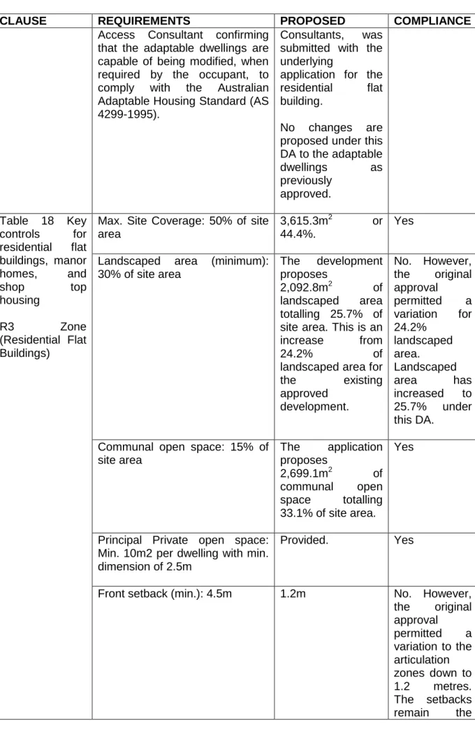
ITEM-2 DA 1102/2018/HA - DEMOLITION OF EXISTING STRUCTURES, SUBDIVISION INTO THREE LOTS, CONSTRUCTION OF 40 TOWNHOUSES IN THREE STAGES AND PARTIAL WIDTH LOCAL ROAD CONSTRUCTION, LOT 84A DP 11104, NO. 21 HYNDS ROAD, BOX HILL
PUBLIC NOTIFICATION OF THE DETERMINATION PURSUANT TO ITEM 20(2)(c) AND (d) OF SCHEDULE 1 OF THE ENVIRONMENTAL PLANNING & ASSESSMENT ACT, 1979
DECISION
The Development Application be refused on the following grounds
Section 4.55 (EP&A Act) – Unsatisfactory.
State Environmental Planning Policy – Building Sustainability Index (BASIX) 2009 - Unsatisfactory
DEVELOPMENT ASSESSMENT UNIT MEETING 13 OCTOBER, 2020
PAGE 4
Box Hill Development Control Plan 2018 - Unsatisfactory
Section 7.11 Contribution: Unable to be calculated.
REASONS FOR THE DECISION
1) The proposal does not include evidence of the consent of adjoining landowners (Nos.
19 and 23 Hynds Road, Box Hill) to enable the partial construction of Ursa Street and Amalthea Street in order to provide access to the development site.
(Section 4.15(a)(iv) and (e) of the Environmental Planning and Assessment Act, 1979).
1) The application, as amended, is not supported by a revised BASIX certificate as required pursuant to State Environmental Planning Policy (Building Sustainability Index: BASIX) 2004.
(Section 4.15(a)(i) of the Environmental Planning and Assessment Act, 1979).
2) The proposed development does not satisfy the requirements of the Box Hill Development Control Plan 2018 with respect to site coverage, cut and fill, adaptable housing, and car parking in Sections 4.1.1 – Cut and Fill, 5.2.8 Garages, Storage, Site Access and Parking and Table 18, 5.5 Adaptable Housing.
(Section 4.15(1)(a)(iii) of the Environmental Planning and Assessment Act, 1979).
3) Insufficient evidence has been provided to demonstrate compliance with the requirements of the Box Hill Development Control Plan 2018 with respect to site coverage controls in Table 18 – Key controls for multi dwelling housing.
(Section 4.15(1)(a)(iii), (b) and (c) of the Environmental Planning and Assessment Act, 1979).
4) The proposal has not demonstrated that a reasonable level of amenity for future residents of the development will be provided in relation to adaptable housing and quality of common open space areas.
(Section 4.15(1)(a)(iii), (b) and (c) of the Environmental Planning and Assessment Act, 1979).
5) The proposed adaptable housing solution is not supported by certification from a suitably qualified Adaptable Housing Consultant to demonstrate compliance with Adaptable Housing Standard (AS 4299-1995).
(Section 4.15(1)(a)(iii) and (c) of the Environmental Planning and Assessment Act, 1979).
6) The proposal has not adequately addressed landscaping, engineering, and waste management concerns.
(Section 4.15(1)(a)(i) and (iii), (b) and (c) of the Environmental Planning and Assessment Act, 1979).
7) The submitted plans are inadequate and contain errors which have prevented a complete assessment of the application.
(Section 4.15(1)(b) and (c) of the Environmental Planning and Assessment Act, 1979).
8) The proposal is not in the public interest as it has not resolved the issue of orderly development by obtaining the consent of the adjoining landowners in order to provide access to the development site and due to its departure from the requirements under the Box Hill Development Control Plan 2018.
(Section 4.15(1)(d) and (e) of the Environmental Planning and Assessment Act 1979).
DEVELOPMENT ASSESSMENT UNIT MEETING 13 OCTOBER, 2020
PAGE 5 HOW COMMUNITY VIEWS WERE TAKEN INTO ACCOUNT IN MAKING THE DECISION The Development Application was notified and no submissions were received.
ITEM-3 DA 1433/2020/LA – FORMALISATION OF UNAUTHORISED WORKS INCLUDING PART DEMOLITION AND RECONFIGURATION OF RETAINING WALLS AND ASSOCIATED EARTHWORKS - LOT 22 DP 703423, 5 YANDIAH PLACE CASTLE HILL
PUBLIC NOTIFICATION OF THE DETERMINATION PURSUANT TO ITEM 20(2)(c) AND (d) OF SCHEDULE 1 OF THE ENVIRONMENTAL PLANNING & ASSESSMENT ACT, 1979
DECISION
The Development Application be refused on the following grounds:
Section 4.15 (EP&A Act) – Unsatisfactory
DCP Part B Section 2 – Residential – Unsatisfactory
1. The proposed development does not comply with the Clauses 2.4, 2.5, 2.14.7, 2.14.9 of Part B Section 2 ‘Residential’ of the Hills Development Control Plan 2012. (Section 4.15(1)(a)(iii) of the Environmental Planning and Assessment Act, 1979).
2. The development is not suitable for the site as it will not provide a satisfactory relationship between the built form and adjoining properties. (Section 4.15(1)(c) of the Environmental Planning and Assessment Act, 1979).
3. The development is considered not to be in the public interest as it contravenes the relevant DCP standards. (Section 4.15(e) of the Environmental Planning and Assessment Act, 1979).
HOW COMMUNITY VIEWS WERE TAKEN INTO ACCOUNT IN MAKING THE DECISION The Development Application was notified and no submissions were received.
DEVELOPMENT ASSESSMENT UNIT MEETING 13 OCTOBER, 2020
PAGE 6
ITEM-2 DA 1616/2020/HA - INSTALLATION OF A
TELECOMMUNICATIONS FACILITY (MOBILE PHONE BASE STATION) - LOT 1 DP 402457, NO. 43 CATTAI RIDGE ROAD GLENORIE
THEME: Shaping Growth
OUTCOME: 5 Well planned and liveable neighbourhoods that meets growth targets and maintains amenity.
STRATEGY:
5.1 The Shire’s natural and built environment is well managed through strategic land use and urban planning that reflects our values and aspirations.
MEETING DATE:
13 OCTOBER 2020
DEVELOPMENT ASSESSMENT UNIT
AUTHOR:
SENIOR TOWN PLANNER AMANDA HAWKINS
RESPONSIBLE OFFICER: MANAGER – DEVELOPMENT ASSESSMENT PAUL OSBORNE
Applicant Lendlease Services
Owner Epsilon Distribution Ministerial Holding Notification 14 days
Number Advised 22 (including the Hills District Historical Society) Number of Submissions 8 (5 objections, 3 in support)
Zoning RU6 Transition
Site Area 2023m2
List of all relevant s4.15(1)(a) matters
Section 4.15 (EP&A Act) – Satisfactory.
SEPP Infrastructure (2007) – Satisfactory.
Local Environment Plan 2019 – Satisfactory.
DCP Part B Section 1 – Rural – Variation, see report.
DCP Part C Section 5 – Telecommunications Facility – Satisfactory.
NSW Telecommunications Facilities Guideline including Broadband – Satisfactory.
Section 7.12 Contribution: $3,372.56 Political Donation Yes
Reason for Referral to DAU 1. Variation to DCP.
2. Submissions received.
Recommendation Approval subject to conditions EXECUTIVE SUMMARY
The Development Application is for a telecommunications facility for the Optus Mobile wireless network. The total height of the facility is 32.8 metres. The applicant has indicated that the facility is necessary to support increasing demand for mobile voice and data services in the suburbs of Glenorie, Kenthurst and Middle Dural as the area was identified as
DEVELOPMENT ASSESSMENT UNIT MEETING 13 OCTOBER, 2020
PAGE 7 an area of poor mobile coverage. The applicant advised that while a number of sites were considered, the subject site was chosen as it best met their criteria.
Eight submissions were received during the notification period which raised issues regarding rural amenity, radiation, visual impact, site selection and impact on property values.
The proposed location of the facility is appropriate in relation to providing a service to the community while minimising any adverse impact on surrounding properties in respect to health, environment and impacts on the visual character of the area.
The application is recommended for approval subject to conditions.
PROPOSAL
The Development Application is for a telecommunications facility for the Optus Mobile wireless network. The proposed facility will provide the area with 3G, 4G and 5G voice and data coverage.
The proposed facility includes the following works:
One new 30m Monopole;
One square headframe mounted on top of the proposed monopole bringing the total height of the structure to 32.8m;
Twelve new Optus panel antennas onto the proposed headframe including the provision of 5G antennas;
One new equipment shelter within a 9.4m x 5m compound area at the base of the proposed facility surrounded by an Optus compound security fence;
The installation of ancillary equipment including but not limited to twenty-six new Remote Radio Units (RRU’s), feeder cables, GPS antenna and cable trays.
The facility is proposed to be located adjacent to the southern property boundary. The facility will be located outside the existing substation fencing to allow for access to the facility as required.
ISSUES FOR CONSIDERATION
1. Compliance with State Environmental Planning Policy (Infrastructure) 2007 The proposed telecommunications facility is permitted with consent on any land under SEPP Infrastructure 2007 (Section 115(1)). A telecommunications facility is defined as:
(a) any part of the infrastructure of a telecommunications network, or
(b) any line, cable, optical fibre, fibre access node, interconnect point, equipment, apparatus, tower, mast, antenna, dish, tunnel, duct, hole, pit, pole or other structure in connection with a telecommunications network, or
(c) any other thing used in or in connection with a telecommunications network.
The proposal complies with the above definition.
Section 115(3) of the SEPP states:
Before determining a development application for development to which this clause applies, the consent authority must take into consideration any guidelines concerning site selection,
DEVELOPMENT ASSESSMENT UNIT MEETING 13 OCTOBER, 2020
PAGE 8 design, construction or operating principles for telecommunications facilities that are issued by the Director-General for the purposes of this clause and published in the Gazette.
The Department of Planning have published the NSW Telecommunications Facilities Guideline including Broadband (2010) which has been considered for this development. This is addressed below in Section 2.
The proposed telecommunication facility is considered satisfactory in regard to the requirements of SEPP Infrastructure 2007.
2. NSW Telecommunications Facilities Guideline including Broadband 2010 The guideline provides principles for the design, siting, construction and operation of telecommunications facilities that apply to proposed telecommunications facilities.
The principles are under the following headings:
Principle 1: A telecommunications facility is to be designed and sited to minimise visual impact
Comment: The proposed facility has been integrated with the existing substation on the lot. The visual impact is minimised through the design and location of the facility. The ancillary equipment will be colour matched to the structure and the ground based equipment will be located adjacent to the monopole and finished in neutral colours. The colours selected complement the existing substation colours to assist in minimising the visual impact.
In addition, existing trees located around the facility will further screen the works as shown in Attachments 6 and 7. The siting and design of the facility is considered to be in accordance with relevant industry guidelines.
Principle 2: Telecommunications facilities should be co-located wherever practical.
Comment: The proposal is not for co-location. The closest facility is 2km north and the site was identified due to existing poor coverage in the area.
Principle 3: Health standards for exposure to radio emissions must be met.
Comment: The proposal has been designed so that the maximum human exposure levels to radiofrequency emissions comply with the Radiation Protection Standard. The proposal has also been assessed by Council’s Senior Environmental Health Officer who raised no concerns with the proposed electromagnetic energy (EME) from the proposed facility. The EME report shows that the maximum radiofrequency signal strength from the facility would equate to 1.21% of the safety limit.
Principle 4: Minimise disturbance and risk and maximise compliance.
Comment: The proposal has been designed to minimise disturbance on the locality where possible. A number of conditions are recommended to control construction activities and minimise disturbance on the locality.
It is considered that the applicant has had regard to the above principles and the development is consistent with the matters outlined within the guidelines.
DEVELOPMENT ASSESSMENT UNIT MEETING 13 OCTOBER, 2020
PAGE 9 3. Compliance with Local Environment Plan 2019
(i) Permissibility
The land is zoned part RU6 Transition under Local Environmental Plan 2019. The proposed telecommunications facility is permissible in the zone.
A telecommunications facility is defined as follows:
(a) any part of the infrastructure of a telecommunications network, or
(b) any line, cable, optical fibre, fibre access node, interconnect point equipment, apparatus, tower, mast, antenna, dish, tunnel, duct, hole, pit, pole or other structure in connection with a telecommunications network, or
(c) any other thing used in or in connection with a telecommunications network.
(ii) Compliance with LEP 2019 – Zone Objectives The objectives of the RU6 Transition zone are as follows:
RU6 Transition zone objectives
To protect and maintain land that provides a transition between rural and other land uses of varying intensities or environmental sensitivities.
To minimise conflict between land uses within this zone and land uses within adjoining zones.
To encourage innovative and sustainable tourist development, sustainable agriculture and the provision of farm produce directly to the public.
Comment:
The subject site currently contains an electrical substation. The proposed telecommunications facility will integrate with the existing development on the lot without interference as it only occupies a small portion of the land outside the area the substation and its associated infrastructure utilises. The proposal will enhance the telecommunication needs of nearby residences.
The proposal is considered satisfactory having regard to the RU6 Transition zone.
(iii) LEP 2019 - Development Standards
The following addresses the principal development standard of the LEP relevant to the subject proposal:
LEP 2019 MAPPING - DEVELOPMENT STANDARDS
STANDARD REQUIRED PROPOSED COMPLIANCE
Building Height 10m (excludes communication devices)
Max. 32.8m
Monopole height: 30m
Yes
The building height definition contained within the LEP building height excludes communication devices, antennae, satellite dishes, masts, flagpoles, chimneys, flues and the like. The definition of a building within the Act can include any structure (which in this case, a mobile tower is considered to be a structure). It is considered that the proposed
DEVELOPMENT ASSESSMENT UNIT MEETING 13 OCTOBER, 2020
PAGE 10 structure functions as a communication device which includes ancillary components listed as exemptions under the building height definition.
It is also noted that certain telecommunication facilities can be approved as complying development under SEPP Infrastructure which can exceed the maximum LEP height standard in certain zoned areas.
(iv) Heritage
The subject site adjoins heritage item I92 ‘House’ in Schedule 5 of the Hills Local Environmental Plan (LEP) 2019. Clause 5.10(4) of the LEP requires the consent authority to consider the effect of the proposed development on the heritage significance of the item or area concerned. An assessment against the objectives of the Clause 5.10 Heritage Conservation is provided below:
(a) to conserve the environmental heritage of The Hills,
The proposed development does not propose any changes to the existing heritage item.
(b) to conserve the heritage significance of heritage items and heritage conservation areas, including associated fabric, settings and views,
The proposal has a building height of 32.8m, and is located within the setback area fronting Cattai Ridge Road.
The heritage curtilage refers to the two timber and stone structures built to the Cattai Ridge Road boundary, and not the surrounding grounds. While the existing vegetation on subject site will partially obscure the proposal from the heritage item, it will likely be visible from private open space within the property. As the private open space does not form part of the heritage curtilage, the proposed works are unlikely to have an impact on the heritage significance of the site.
Notwithstanding this, the existing mix of mature conifer trees and vegetation adjoining the timber and stone barn provide significant screening of the proposal from any eastern facing outlooks within the barn (see Figure 1 below). Likewise, the proposed pole is unlikely to be visible from the cottage due to the extended roof design along the ‘modern’ eastern facing windows. Accordingly, the proposed works are not readily visible from within the heritage item, and are therefore unlikely to impact its heritage significance.
DEVELOPMENT ASSESSMENT UNIT MEETING 13 OCTOBER, 2020
PAGE 11 Figure 1: Heritage Impacts Analysis
(c) to conserve archaeological sites
No items of archaeological significance are identified at the site. Notwithstanding this, any disturbance of an archaeological item or relics will require an excavation permit from the Heritage Council of NSW under the relics provisions of the Heritage Act 1977.
In the event that evidence of the Aboriginal occupation of the site is identified during any phase of onsite works, all works in the affected area should stop, the area adequately protected and OEH informed about the discovery under section 89(A) of the National Parks and Wildlife Act 1974.
(d) to conserve Aboriginal objects and Aboriginal places of heritage significance.
N/A – Item is of European heritage.
As a result, the proposed telecommunication facility is considered satisfactory in regard to the requirements of LEP 2019.
4. DCP Part B Section 1 – Rural
The proposed telecommunications facility has been assessed against the relevant provisions of the Rural DCP and the following non-compliance was identified:
DEVELOPMENT STANDARD
DCP
REQUIREMENT
PROPOSED DEVELOPMENT
COMPLIANCE
Front Setback 10m Nil setback - The
proposed facility is located on the property boundary fronting Cattai Ridge Road
No Barn
Subject Site
Approximate Location of Proposed Works
Mature Screening Vegetation
No. 41 Cattai Ridge Road
(I92)
Cottage
DEVELOPMENT ASSESSMENT UNIT MEETING 13 OCTOBER, 2020
PAGE 12 The objectives of this clause of the DCP are:
The scale, siting and visual appearance of new development maintains the open rural feel of the landscape and preserves scenic and environmental qualities of the area.
The location of new rural/ residential development is to have regard to the potential impacts arising from existing adjacent rural business activities.
Comment:
The proposed facility is located adjacent to the Cattai Ridge Road boundary. Locating the facility within the secure fencing that encloses the substation was not possible as unrestricted access to the proposed facility is required. The location of the facility will not result in the removal of any of the mature trees on the lot that will assist in screening the development.
As detailed in this report, the proposed facility is located on a small portion of a site which currently contains an electrical substation. Locating the proposed facility on the same allotment as the existing substation reduces the proliferation of these services throughout the suburb and therefore assists in maintaining the rural feel of the area and minimises the impact on nearby rural residential properties.
The proposed facility is a permissible form of development in the zone and the proposed location of the facility on the lot is considered to be acceptable in this instance.
5. DCP Part C Section 5 – Telecommunications Facilities
The proposed telecommunications facility has been assessed against DCP Part C Section 5 – Telecommunications Facilities. The development controls relate to visual amenity, co- location, location, heritage, environment, design of the facility and health control requirements. The proposed facility has been integrated with the locality and the visual impact is minimised through the design and location of the facility.
There are currently no existing carrier telecommunications facilities in the vicinity with the required position, height or structural suitability that are potentially capable of providing the service on which the proposed equipment can be co-located.
The facility has been sited within a rural area and is appropriately located. The site is not located close to any sensitive land uses. The facility will be surrounded by a 2.125m high mesh fence to restrict public access. The proposed facility will comply with relevant regulatory health exposure level requirements.
The proposed telecommunications facility is considered to be satisfactory in regard to DCP Part C Section 5 – Telecommunication Facilities.
6. Issues Raised in Submissions
The proposal was notified for 14 days and eight submissions were received. Five of the submissions raised objections to the proposal and the remaining three were either in support or simply provided commentary on the type of development proposed.
The issues raised in the submissions are summarised below.
DEVELOPMENT ASSESSMENT UNIT MEETING 13 OCTOBER, 2020
PAGE 13
ISSUE/OBJECTION COMMENT
The proposed facility is too close to the homes in the area and will negatively impact on quality of life and the natural environment.
The surrounding houses are set on rural 5 acre blocks with an immense amount of bushland and shrubs. The proposed facility will visually impair the area.
The proposed development occupies a small portion of a site which currently contains an electrical substation, a similar essential service. Locating the proposed facility on the same allotment as the existing substation reduces the proliferation of these services throughout the suburb.
The proposed location is considered to be the most suitable in terms of equitable impacts on the surrounding area as it avoids the placement of a telecommunications facility on a residential lot.
I cannot see how the new 32.8m tower with 12 panels which is higher than a majority of all trees in the area can have no visual impact.
It is acknowledged that due to the height proposed, the facility will be visible from
adjoining properties. Mobile
telecommunications facilities are required to protrude above the surrounding landscape in order to function correctly.
If they are allowed to erect this tower it will have a significant visually impact for a minimum of 20 properties.
The applicant has taken several steps to reduce the visual impact of the proposed facility. The lowest height option pole which meets Optus’ Radio Frequency (RF) design solution has been selected. The proposal also includes a slim monopole rather than a bulk lattice tower or mast. In addition, the facility will be able to provide future colocation options for other carriers which will reduce the proliferation of such structures in the area.
The telecommunications tower is taller than anything in its environment and will look like an alien spaceship floating in the sky.
It is acknowledged that the height of the tower exceeds the surrounding tree canopy however as detailed above, the facility is required to protrude in order to function correctly.
There is no other structure that could distract or camouflage this structure and it will be an “eye sore” which hundreds of local residents will drive by on a daily basis as the location is not well concealed.
As detailed above, the applicant has taken steps to reduce the visual impact of the proposed facility however it is required to protrude in order to function correctly.
The structure is out of character and not in line with the environmental considerations that were made when putting up the substation.
The facility is proposed to be located on a site which currently contains an electrical substation, a similar essential service.
Locating the proposed facility on the same allotment as the existing substation reduces the proliferation of these services throughout the suburb.
As detailed in this report, the applicant has submitted an EME Report which demonstrates that the emissions from the
DEVELOPMENT ASSESSMENT UNIT MEETING 13 OCTOBER, 2020
PAGE 14
ISSUE/OBJECTION COMMENT
facility will be well within the parameters set for these facilities.
Proper coloured fencing, green building panels, a structure that sits below the current tree lines, new vegetation and landscaping were done to assimilate the substation into the environment.
This tower contradicts, ignores and does the exact opposite of what was achieved here in the 2011 substation build.
The applicant advised that Optus is willing to paint the structure an alternative colour however they noted that through their experience, standard plain grey colour as a visual mitigation strategy works best. It is considered that a grey facility tends to blend best with the skyline in all weathers, minimising visual impact on the surrounding area.
By adding the new tower structure, this developer will be removing some of the vegetation, placing a chain metal mesh surrounding it and erecting a tower higher that all the existing vegetation and trees.
The proposal does not incorporate any tree removal. However, it is expected that in due course, trees can sometimes encroach onto the facility. In this instance, tree pruning will be required. Presently, only minimal shrub pruning is required. As detailed above, the tower is required to protrude above the tree canopy in order to function.
The photos submitted with the DA are misleading and make it look as though the trees are of similar height to the tower, which they are not.
The photomontages submitted with the Development Application are indicative of how the proposed facility will sit on the subject site when viewed from the road. The proposed height of the tower is clearly detailed on the architectural plans and supporting documentation.
Maybe they could disguise it as a flagpole. This is not possible due to the headframe required for the facility to function.
The EME Report does not appear to consider the frequency of the existing substation and the proposed facility combined. Do they together omit a higher frequency? Is it safe to have the two together on one lot?
It makes more sense to distance the two facilities from each other so residents experience safe levels from each facility.
The proposed EME Report captures the predicted maximum radio frequency emissions of the telecommunications facility.
Mobile Carriers including Optus must operate within the operational standards set by the Australian Radiation Protection and Nuclear Safety Agency (ARPANSA) and regulated by the Australian Communication and Media Authority (ACMA). The operational standards known as the Radiocommunications (Electromagnetic Radiation – Human Exposure) Standard 2014, prepared by ARPANSA are based on international standards set by the International Commission for Non-Ionizing Radiation protection (ICNRP) – an agency associated with the World Health Organisation (WHO).
The applicant advised that electricity powerlines, substations, transformers and other electrical sources such as common
DEVELOPMENT ASSESSMENT UNIT MEETING 13 OCTOBER, 2020
PAGE 15
ISSUE/OBJECTION COMMENT
electrical appliances emit extremely low frequency (ELF) electric and magnetic fields (EMF), these are not governed by the above standard.
The frequencies of both the substation and the proposed facility sit well within the safety parameters set for each facility. Siting the structure on the same property as the substation was a conscious decision by the applicant to reduce the visual impact of the proposal.
Local real estate agents have advised that while the tower may be good from a telecommunication perspective, it will negatively impact property values.
There is no evidence to suggest that approval of the subject application will adversely impact property values. In any event, this is not a consideration in the assessment of a Development Application.
Optus is not the most popular carrier in the area. Telstra is.
If the proposed facility is erected, residents will presumably need to switch carriers to gain better reception.
Council should carry out further research to ascertain if an Optus tower is the best choice for Glenorie.
It is not within the scope of assessment of a Development Application for the consent authority to ascertain demand for a product.
The applicant has advised that there is an ever increasing demand for services in the area.
There is a worldwide stigma in the media regarding 5G towers.
The applicant advised that the Australian Radiation Protection and Nuclear Safety Agency (ARPANSA) have recently addressed this information and stated that:
“Contrary to some claims, there are no established health effects from the radio waves that the 5G network uses……
We urge you to be cautious of claims from anti-5G campaigns. These campaigns are generating unfounded fear and concern within the community. We have seen increasing misinformation about health effects, our role, and 5G or radio waves generally.”
Internet research has revealed that tower like that emit noise.
Noise emanating from the facility is required to comply with the background noise levels prescribed by Australian Standard AS1055.
There is also no written evidence that states the mobile towers will not cause cancer or chronic diseases. I fear that with time investigations by third parties will provide evidence that mobile phone towers become identified hazards to people.
The facility is to be installed, designed and certified by qualified professionals in accordance with all relevant Australian Standards. The standard operates by placing a limit on the strength of the signal (or RF EME) that Carriers can transmit to and from any network base station. The general public health standard is not based on distance
DEVELOPMENT ASSESSMENT UNIT MEETING 13 OCTOBER, 2020
PAGE 16
ISSUE/OBJECTION COMMENT
limitations, or the creation of “buffer zones”.
The environmental standard restricts the signal strength to a level low enough to protect everyone at all times. It has a significant safety margin, or precautionary approach, built into it.
The proposed facility may also impact on wildlife, plants and animals.
As detailed above, the application was accompanied by an EME Report which provided commentary on the predicted and existing maximum radio frequency emissions of the telecommunications facility and substation.
The frequencies of both the substation and the proposed facility sit well within the safety parameters set for each facility.
Until such time as testing of the effects of these frequencies have been done, no approvals should be issued.
The proposed development is a permissible form of development in the zone. The applicant has demonstrated that the proposed facility sits within the current safety parameters.
The facility will result in further health issues for those with EMF hypersensitivity.
As detailed above, the applicant has submitted documentation to demonstrate that the proposed facility sits within the current safety parameters.
Council should refuse the application and press the Federal Government to hold a royal commission into the effects on biological life of these frequencies.
As detailed in this report, the applicant has demonstrated that the proposed facility is an appropriate form of development in the RU6 Transition zone.
Shouldn’t the facility have to be set back from the property boundary?
The Development Control Plan Part C Section 5 – Telecommunication Facilities does not impose a setback requirement for these facilities.
The front setback control for new rural development has been discussed in Section 4 of this report.
The proposed location was selected as it allowed the facility to be constructed on the property without impeding the ongoing function of the existing substation. For security reasons, the proposed facility cannot sit within the Substation Compound.
The facility should be relocated to a less populated area.
This issue has been already addressed in the table above.
Residents were promised nothing further would happen on this property after the substation was built.
The property owner is not prohibited from considering proposals on their land provided they are permitted forms of development in the zone.
DEVELOPMENT ASSESSMENT UNIT MEETING 13 OCTOBER, 2020
PAGE 17 7. Internal Referrals
The application was referred to following sections of Council:
Environmental Health Ecology
No objection was raised to the proposal subject to conditions.
CONCLUSION
The Development Application has been assessed against the relevant heads of consideration under Section 4.15 of the Environmental Planning and Assessment Act, 1979, State Environmental Planning Policy (Infrastructure) 2007, the NSW Telecommunications Facilities Guideline, The Hills Local Environmental Plan 2019 and The Hills Development Control Plan 2012 and is considered satisfactory. The proposal will benefit the broader community and improve the telecommunications network in the area.
The issues raised in the submissions have been addressed in the report and do not warrant refusal of the application.
Approval is recommended subject to conditions.
IMPACTS Financial
This matter has no direct financial impact upon Council's adopted budget or forward estimates.
The Hills Future Community Strategic Plan
The proposed development is consistent with the planning principles, vision and objectives outlined within “Hills 2026 – Looking Towards the Future” as the proposed development provides for satisfactory urban growth without adverse environmental or social amenity impacts and ensures a consistent built form is provided with respect to the streetscape and general locality.
RECOMMENDATION
The Development Application be approved subject to the following conditions of consent:
GENERAL MATTERS
1. Development in Accordance with Submitted Plans
The development being carried out in accordance with the following approved plans and details, stamped and returned with this consent except where amended by other conditions of consent.
REFERENCED PLANS AND DOCUMENTS
DRAWING NO. DESCRIPTION REVISION DATE
S2028-P1 Site Plan 01 07/05/2020
S2028-P2 Site Layout Plan 01 07/05/2020
S2028-P3 Elevation 01 07/05/2020
DEVELOPMENT ASSESSMENT UNIT MEETING 13 OCTOBER, 2020
PAGE 18 No work (including excavation, land fill or earth reshaping) shall be undertaken prior to the issue of the Construction Certificate, where a Construction Certificate is required.
2. External Finishes
External finishes and colours shall be in accordance with the details submitted with the development application and approved with this consent.
3. Construction Certificate
Prior to construction of the approved development, it is necessary to obtain a Construction Certificate. A Construction Certificate may be issued by Council or an Accredited Certifier.
Plans submitted with the Construction Certificate are to be amended to incorporate the conditions of the Development Consent.
4. Building Work to be in Accordance with BCA
All building work must be carried out in accordance with the provisions of the Building Code of Australia.
5. Protection of Existing Trees and Native Vegetation
No additional native vegetation (trees and understorey) is to be removed for the creation of an Asset Protection Zone or otherwise without prior consent of Council.
6. Management of Construction and/or Demolition Waste
Waste materials must be appropriately stored and secured within a designated waste area onsite at all times, prior to its reuse onsite or being sent offsite. This includes waste materials such as paper and containers which must not litter the site or leave the site onto neighbouring public or private property. A separate dedicated bin must be provided onsite by the builder for the disposal of waste materials such as paper, containers and food scraps generated by all workers. Building waste containers are not permitted to be placed on public property at any time unless a separate application is approved by Council to locate a building waste container in a public place.
Any material moved offsite is to be transported in accordance with the requirements of the Protection of the Environment Operations Act 1997 and only to a place that can lawfully be used as a waste facility. The separation and recycling of the following waste materials is required: metals, timber, masonry products and clean waste plasterboard. This can be achieved by source separation onsite, that is, a bin for metal waste, a bin for timber, a bin for bricks and so on. Alternatively, mixed waste may be stored in one or more bins and sent to a waste contractor or transfer/sorting station that will sort the waste on their premises for recycling. Receipts of all waste/recycling tipping must be kept onsite at all times and produced in a legible form to any authorised officer of the Council who asks to see them.
Transporters of asbestos waste (of any load over 100kg of asbestos waste or 10 square metres or more of asbestos sheeting) must provide information to the NSW EPA regarding the movement of waste using their WasteLocate online reporting tool www.wastelocate.epa.nsw.gov.au.
PRIOR TO THE ISSUE OF A CONSTRUCTION CERTIFICATE 7. Section 7.12 Contribution
Pursuant to section 4.17 (1) of the Environmental Planning and Assessment Act 1979, and The Hills Section 7.12 Contributions Plan, a contribution of $3,372.56 shall be paid to Council. This amount is to be adjusted at the time of the actual payment in accordance with the provisions of the Hills Section 7.12 Contributions Plan.
The contribution is to be paid prior to the issue of the Construction Certificate.
DEVELOPMENT ASSESSMENT UNIT MEETING 13 OCTOBER, 2020
PAGE 19 You are advised that the maximum percentage of the levy for development under section 7.12 of the Act having a proposed construction cost is within the range specified in the table below;
Proposed cost of the development Maximum percentage of the levy
Up to $100,000 Nil
$100,001 - $200,000 0.5 %
More than $200,000 1%
PRIOR TO WORK COMMENCING ON THE SITE 8. Protection of Existing Trees
The trees that are to be retained are to be protected during all works strictly in accordance with AS4970- 2009 Protection of Trees on Development Sites.
At a minimum a 1.8m high chain-wire fence is to be erected at least three (3) metres from the base of each tree and is to be in place prior to works commencing to restrict the following occurring:
Stockpiling of materials within the root protection zone, Placement of fill within the root protection zone,
Parking of vehicles within the root protection zone, Compaction of soil within the root protection zone.
All areas within the root protection zone are to be mulched with composted leaf mulch to a depth of not less than 100mm.
A sign is to be erected indicating the trees are protected.
The installation of services within the root protection zone is not to be undertaken without prior consent from Council.
9. Sydney Water Building Plan Approval
A building plan approval must be obtained from Sydney Water Tap in™ to ensure that the approved development will not impact Sydney Water infrastructure.
A copy of the building plan approval and receipt from Sydney Water Tap in™ (if not already provided) must be submitted to the Principal Certifier upon request prior to works commencing.
Please refer to the website http://www.sydneywater.com.au/tapin/index.htm, Sydney Water Tap in™, or telephone 13 20 92.
10. Management of Building Sites
The erection of suitable fencing or other measures to restrict public access to the site and building works, materials or equipment when the building work is not in progress or the site is otherwise unoccupied.
The erection of a sign, in a prominent position, stating that unauthorised entry to the site is not permitted and giving an after hours contact name and telephone number.
11. Approved Temporary Closet
An approved temporary closet connected to the sewers of Sydney Water, or alternatively an approved chemical closet is to be provided on the land, prior to building operations being commenced.
DEVELOPMENT ASSESSMENT UNIT MEETING 13 OCTOBER, 2020
PAGE 20 12. Erosion and Sedimentation Controls
Erosion and sedimentation controls shall be in place prior to the commencement of site works; and maintained throughout construction activities until the site is landscaped and/or suitably revegetated. The controls shall be in accordance with the details approved by Council and/or as directed by Council Officers. These requirements shall be in accordance with Managing Urban Stormwater – Soils and Construction produced by the NSW Department of Housing (Blue Book).
13. Details and Signage - Principal Contractor and Principal Certifier Details
Prior to work commencing, submit to the Principal Certifier notification in writing of the principal contractor’s (builder) name, address, phone number, email address and licence number.
No later than two days before work commences, Council is to have received written details of the Principal Certifier in accordance with Clause 103 of the Environmental Planning and Assessment Regulations 2000.
Signage
A sign is to be erected in accordance with Clause 98A(2) of the Environmental Planning and Assessment Regulations 2000. The sign is to be erected in a prominent position and show – a) the name, address and phone number of the Principal Certifier for the work,
b) the name and out of working hours contact phone number of the principal contractor/person responsible for the work.
The sign must state that unauthorised entry to the work site is prohibited.
14. Waste Management Details Required
Prior to the commencement of works, the location of waste disposal and recycling for all construction and/ or demolition waste materials (bricks, concrete, timber and so on) must be submitted to and approved by the Principal Certifying Authority. Alternatively, details of an appropriately licensed skip bin hire company or site clean company can be provided where the company is engaged to undertake all works during construction of the development (collection, transportation and disposal).
DURING CONSTRUCTION 15. Hours of Work
Work on the project to be limited to the following hours: - Monday to Saturday - 7.00am to 5.00pm;
No work to be carried out on Sunday or Public Holidays.
The builder/contractor shall be responsible to instruct and control sub-contractors regarding the hours of work.
16. Survey Report and Site Sketch
A survey report and site sketch signed and dated (including contact details) by the registered land surveyor may be requested by the Principal Certifier during construction. The survey shall confirm the location of the building/structure in relation to all boundaries and/or levels.
As of September 2018 the validity of surveys has been restricted by legislation to 2 years after issue.
17. Critical Stage Inspections and Inspections Nominated by the Principal Certifier Section 6.6 of the Environmental Planning and Assessment Act 1979 requires critical stage inspections to be carried out for building work as prescribed by Clause 162A of the Environmental Planning and Assessment Regulation 2000. Prior to allowing building works
DEVELOPMENT ASSESSMENT UNIT MEETING 13 OCTOBER, 2020
PAGE 21 to commence the Principal Certifier must give notice of these inspections pursuant to Clause 103A of the Environmental Planning and Assessment Regulation 2000.
An Occupation Certificate cannot be issued and the building may not be able to be used or occupied where any mandatory critical stage inspection or other inspection required by the Principal Certifier is not carried out. Inspections can only be carried out by the Principal Certifier unless agreed to by the Principal Certifier beforehand and subject to that person being an accredited certifier.
18. Dust Control
The emission of dust must be controlled to minimise nuisance to the occupants of the surrounding premises. In the absence of any alternative measures, the following measures must be taken to control the emission of dust:
Dust screens must be erected around the perimeter of the site and be kept in good repair for the duration of the construction work;
All dusty surfaces must be wet down and suppressed by means of a fine water spray.
Water used for dust suppression must not cause water pollution; and
All stockpiles of materials that are likely to generate dust must be kept damp or covered.
19. Construction Noise
The emission of noise from the construction of the development shall comply with the Interim Construction Noise Guideline published by the Department of Environment and Climate Change (July 2009).
THE USE OF THE SITE 20. Offensive Noise
The use of the premises, building services, equipment, machinery and ancillary fittings shall not give rise to “offensive noise” as defined under the provisions of the Protection of the Environment Operation Act 1997.
ATTACHMENTS 1. Locality Plan 2. Aerial Photograph 3. Site Plan
4. Site Layout Plan 5. Elevation
6. Photo Montages 7. Site Photographs
DEVELOPMENT ASSESSMENT UNIT MEETING 13 OCTOBER, 2020
PAGE 22 ATTACHMENT 1 – LOCALITY PLAN
DEVELOPMENT ASSESSMENT UNIT MEETING 13 OCTOBER, 2020
PAGE 23 ATTACHMENT 2 – AERIAL PHOTOGRAPH
DEVELOPMENT ASSESSMENT UNIT MEETING 13 OCTOBER, 2020
PAGE 24 ATTACHMENT 3 – SITE PLAN
DEVELOPMENT ASSESSMENT UNIT MEETING 13 OCTOBER, 2020
PAGE 25 ATTACHMENT 4 – SITE LAYOUT PLAN
DEVELOPMENT ASSESSMENT UNIT MEETING 13 OCTOBER, 2020
PAGE 26 ATTACHMENT 5 – ELEVATION
ATTACHMENT 6 – PHOTO MONTAGES
DEVELOPMENT ASSESSMENT UNIT MEETING 13 OCTOBER, 2020
PAGE 27
DEVELOPMENT ASSESSMENT UNIT MEETING 13 OCTOBER, 2020
PAGE 28 ATTACHMENT 7 – SITE PHOTOGRAPHS
The area of the site the facility is proposed to be located on
View from Cattai Ridge Rd
DEVELOPMENT ASSESSMENT UNIT MEETING 13 OCTOBER, 2020
PAGE 29 The area of the site the facility is proposed to be located on
DEVELOPMENT ASSESSMENT UNIT MEETING 13 OCTOBER, 2020
PAGE 30 Looking East along Cattai Ridge Rd
DEVELOPMENT ASSESSMENT UNIT MEETING 13 OCTOBER, 2020
PAGE 31 Looking West along Cattai Ridge Rd
DEVELOPMENT ASSESSMENT UNIT MEETING 13 OCTOBER, 2020
PAGE 32 ITEM-3 DAU REPORT - DA 1135/2020/HA - DETACHED SECONDARY DWELLING PURSUANT TO SEPP AFFORDABLE RENTAL HOUSING 2009 - LOT 32 DP 227396, 5 GREGORY AVENUE, BAULKHAM HILLS
THEME: Shaping Growth
OUTCOME: 5 Well planned and liveable neighbourhoods that meets growth targets and maintains amenity.
STRATEGY:
5.1 The Shire’s natural and built environment is well managed through strategic land use and urban planning that reflects our values and aspirations.
MEETING DATE: 13 OCTOBER 2020
DEVELOPMENT ASSESSMENT UNIT
AUTHOR: SENIOR TOWN PLANNER
EAMON MURPHY
RESPONSIBLE OFFICER: PRINCIPAL COORDINATOR KRISTINE MCKENZIE
Applicant L. Sun
Owner L. Sun and S.H. Guo
Notification 14 days
Number Advised 1st Notification: 15 2nd Notification: 15 Number of Submissions 1st Notification: 2
2nd Notification: 1
Zoning R2 Low Density Residential
Site Area 733m2
List of all relevant s4.15(1)(a) matters
Section 4.15 (EP&A Act) – Satisfactory
SEPP (Affordable Rental Housing) 2009 – Satisfactory.
LEP 2019 – Satisfactory.
DCP Part B Section 2 Residential – See report.
Section 7.12 Contribution – N/A
Political Donation None Disclosed
Reasons for Referral to DAU 1. Variation to DCP 2. Submissions received.
Recommendation Approval subject to conditions.
DEVELOPMENT ASSESSMENT UNIT MEETING 13 OCTOBER, 2020
PAGE 33 EXECUTIVE SUMMARY
The Development Application is for the construction of a detached secondary dwelling pursuant to SEPP Affordable Rental Housing (SEPP ARH) 2009. The proposal has been assessed against the requirements of the SEPP and the proposal complies with the relevant SEPP requirements.
The proposal has also been assessed against the requirements of DCP 2012 Part B Section 2 – Residential however it should be noted that these are merit considerations only given that SEPP ARH 2009 applies. The proposed development complies with the DCP requirements with the exception of the rear setback. The DCP requires a minimum rear setback of 4 metres. The proposed rear setback is 1.517 metres. The proposed setback is considered satisfactory given the single storey design and given that no unreasonable overshadowing or privacy impacts will result from the secondary dwelling.
The Development Application was notified on two occasions. Two submissions were received during the first notification period. The Development Application was notified for a second time as amended plans were submitted which relocated the secondary dwelling. One submission was received during the second notification period. The issues raised primarily relate to inadequate onsite parking, increased street parking and vehicle movements, damage to adjoining property fences, stormwater runoff, privacy, character, future occupants, dwelling location, building orientation, height, overshadowing and general maintenance of the property. The proposed secondary dwelling is considered to be satisfactory in terms of its design and relationship to adjoining properties. The proposal will not unreasonably impact on existing or future adjoining dwellings in respect to amenity or create unreasonable traffic or parking impacts.
The Development Application is recommended for approval subject to conditions.
BACKGROUND
The subject Development Application was lodged on 27 February 2020.
The proposal was notified for 14 days on two occasions and two submissions were received during the first notification period and one submission was received during the second notification period.
A letter was sent to the applicant requesting the submission of amended plans on 24 July 2020.
Additional information was received on 20 August 2020.
PROPOSAL
The Development Application is for the construction of a detached secondary dwelling located behind the principal dwelling. The dwelling comprises two bedrooms, bathroom, laundry and kitchen/ living area.
The proposed secondary dwelling will be constructed of face brick to match the existing dwelling and a pitched tiled roof also to match existing dwelling. The colour scheme will consist of terracotta coloured face brick and brown roof tiles to match the existing house.
DEVELOPMENT ASSESSMENT UNIT MEETING 13 OCTOBER, 2020
PAGE 34 ISSUES FOR CONSIDERATION
1. Compliance with SEPP (Affordable Rental Housing) 2009
The secondary dwelling is proposed under the provisions of SEPP ARH 2009. The subject site has an area of 733m2 and exceeds the SEPP site area requirements of 450m2. The SEPP specifies a maximum secondary dwelling floor area of 60m2, with a floor area of 60m2 proposed.
The SEPP contains additional development standards for secondary dwellings where approval is sought as Complying Development. The development standards include a minimum 3 metre rear setback. The proposal does not comply with this standard. However, given approval is sought under a Development Application, and not a Complying Development Certificate, the development standard does not apply and the rear setback is a merit consideration. The merits of the rear setback are addressed in Section 2 of this report.
The proposal satisfies the relevant development standards of SEPP ARH 2009.
2. Compliance with DCP Part B Section 2 – Residential
The proposal has been assessed against the relevant requirements of the DCP. It is noted that these are merit considerations only given that SEPP ARH 2009 applies. The proposal achieves compliance with the DCP with the exception of the following:
DEVELOPMENT STANDARD
DCP REQUIREMENTS
PROPOSED DEVELOPMENT
COMPLIANCE Rear Setback 4 metres 1.517 metres to the
secondary dwelling.
No, however the secondary dwelling will
not result in
unreasonable amenity impacts.
a) Rear Setback
The DCP requires a minimum rear setback of 4 metres for single dwellings. The proposed secondary dwelling has a proposed rear setback of 1.517 metres.
SEPP ARH 2009 does not include specific controls for building setbacks for secondary dwellings where approval is sought under a Development Application. Accordingly, the setbacks are considered on merit.
Attachment 3 shows the proposed site plan.
The applicant has provided the following justification for the setback:
For privacy and solar access reason, granny flat is located at rear and also due to the distance; you have more privacy and private open space for main house. Furthermore, granny flat as second dwelling at rear of property is approved by almost all Councils. Thanks for your consideration.
DEVELOPMENT ASSESSMENT UNIT MEETING 13 OCTOBER, 2020
PAGE 35 Comment:
The relevant objectives of the setback standards in the DCP are:
(i) To provide setbacks that complements the streetscape and protects the privacy and sunlight to adjacent dwellings in accordance with ESD objective 7.
(ii) To ensure that new development is sensitive to the landscape setting, site constraints and desired future character of the street and locality.
(iii) To ensure that the appearance of new development is of a high visual quality and enhances the streetscape.
The application does not meet the DCP rear setback requirements however the proposed setback satisfies the relevant objectives of the DCP. In this regard the proposed single storey secondary dwelling will not unreasonably impact on privacy or solar impacts to adjoining properties. The proposal has considered the site constraints and given that the secondary dwelling is located behind the principal dwelling, it will not impact on streetscape.
The proposal is also considered satisfactory as the proposed secondary dwelling provides appropriate side setbacks. In this regard the DCP requires a 900mm side setback, with side setbacks of 4.172m (to the western boundary) and 4.2m to the secondary dwelling and 1.2m to the deck (to the eastern boundary).
The existing dwelling and secondary dwelling are provided with appropriate private open space which receives adequate solar access. On merit, the rear setback is considered satisfactory and will not adversely impact on adjoining properties. The proposal is not considered to result in any unreasonable impact beyond that of a compliant development, and is therefore considered a suitable outcome for the site.
The proposed rear setback is therefore considered satisfactory, on merit, in this instance.
3. Issues Raised in Submissions
The Development Application was notified on two occasions. Two submissions were received during the first notification period and one submission was received during the second notification period. The issues raised in the submissions are summarised below.
First notification period
ISSUE/OBJECTION COMMENT
Concern about not enough off-street parking for two dwellings.
It will lead to an increase in on-street parking. Worried that cars will park in front of neighbouring properties. Will be a safety hazard and will create issues for garbage trucks.
The DCP requires that at least one car space is provided for dwellings with a floor area of less than 125m2.
SEPP ARH 2009 does not require parking to be provided for a secondary dwelling. The comment in regard to one car space being required for a dwelling under 125m2 relates to dual occupancy development. This requirement is not applicable to a secondary dwelling.
DEVELOPMENT ASSESSMENT UNIT MEETING 13 OCTOBER, 2020
PAGE 36
ISSUE/OBJECTION COMMENT
The driveway is not wide enough to cater for additional vehicles.
SEPP ARH 2009 does not require increased parking provision.
No other secondary dwellings in area so not in keeping with character of low density area.
Not enough infrastructure for new developments that increase the density of the residential area.
Secondary dwellings are permitted in the R2 Low Density Residential area under the provisions of SEPP ARH 2009.
The proposed secondary dwelling will not create an unreasonable impact on existing services and infrastructure. Notwithstanding this conditions have been recommended which require building plan approval from Sydney Water and consultation with service authorities (See Conditions 11 and 13).
Proposal will result in privacy impacts to adjoining properties. Location of dwelling at rear of lot will enable overlooking into neighbours.
The proposal is for a single storey structure. The proposal will provide appropriate side setbacks and separation to adjoining properties which will minimise any potential privacy impacts. It is also noted that the proposed secondary dwelling and deck is to be located adjacent to the adjoining property’s detached garage, which will act as a barrier between the existing dwelling and the proposed secondary dwelling, reducing any potential for privacy concerns. In addition, the windows on the western (side) elevation are high- light windows with a sill height of 1.6 metres from the finished floor level.
Questioned why dwelling is not in a north- south orientation like other dwellings in area.
There is no requirement or control in SEPP ARH 2009 regarding dwelling orientation. Nevertheless a review of other properties in the area indicate they include both north-south and east-west orientations dependent on location.
Concerned that secondary dwelling will breach the maximum height of 3.6m
The maximum permitted height for a dwelling is 9m under LEP 2019. The proposed height of the secondary dwelling is a maximum of 5.393m.
Concerned whether existing boundary fences will be replaced or damaged during construction.
It is not proposed to replace the existing boundary fences.
The owner of the subject property and/or their builder will be responsible for any damage caused during construction. To mitigate concerns about potential fence damage during construction, a condition is recommended requiring the replacement or rectification of the fence if any damage occurs (See Condition 10).
Questioned how stormwater will be managed. Concerned that runoff from the roof will end up in adjoining properties.
The lot falls to the street and it is proposed to connect the secondary dwelling to the existing system which drains to the street/kerb. The roof water will be collected by gutters and downpipes and be connected to a pit at the front of the lot