A MOTION WAS MOVED BY THE MAYOR AND SECOND BY COUNCIL HODGES THAT these Mayor's Minutes be received. A MOTION WAS MOVED BY COUNCILMAN HODGES AND SECOND BY COUNCIL HAY OAM THAT the Recommendation contained in the report be accepted.
MINUTES of the duly convened Ordinary Meeting of The Hills Shire Council held in the Council Chambers on 10 May 2022
Council grant owner’s consent for the lodgement of a Subdivision Certificate Application with the Plan of Subdivision, 88B Instrument and all other required documents for
MINUTES of the duly called ordinary meeting of The Hills Shire Council held in the Council Chamber on the 10th day of May 2022.
Upon registration of the subdivision, the subject land is dedicated as Public Road pursuant to Section 10 of the Roads Act 1993 in the NSW Government Gazette
LEASE VARIATION AND CHANGE IN CONTROL - LEASE TO FULLERTON HEALTH MEDICAL CENTRES SHOP 1, 269 OLD
219 RESOLUTION
Council consent to the change in control to Partnered Health Medical Centres Pty Ltd and authorise for execution under seal
Council authorise the execution of the Lease variation under seal
POST EXHIBITION REPORT - CODE OF MEETING PRACTICE
A MOTION WAS MOVED BY COUNCILLOR BLUE AND SECONDED BY COUNCILLOR HODGES THAT the Recommendation contained in the report be adopted
THE MOTION WAS PUT AND CARRIED
220 RESOLUTION
COMMUNITY GRANTS PROGRAM 2021/2022
A MOTION WAS MOVED BY COUNCILLOR HODGES AND SECONDED BY COUNCILLOR ELLIS THAT the Recommendation contained in the report be adopted
221 RESOLUTION
The General Manager be authorised to enter into funding agreements for financial assistance for the non-for-profit organisations detailed in Attachment 1
MINUTES of the duly convened Ordinary Meeting of The Hills Shire Council held in the Council Chambers on 10 May 2022 Council Chambers on 10 May 2022.
A second opportunity be provided to the eighteen applicants that did not proceed to assessment panel to re-submit their original application with the missing
QUESTIONS WITHOUT NOTICE 222 CERTIFICATION
223 HAWKESBURY RIVER FLOOD RECOVERY
CLOSED COUNCIL
A MOTION WAS MOVED BY COUNCILLOR BLUE AND SECONDED BY COUNCILLOR HODGES THAT
ITEM NO.: 13
SUBJECT: CONFIDENTIAL TENDER FOR BUILDING WORKS Associated Report: N/A
THE MOTION WAS PUT AND CARRIED 224 RESOLUTION
- pm Council entered into Closed Session
- pm Councillor Hodges having previously declared a non-pecuniary, less than significant conflict of interest remained in the room
CONFIDENTIAL TENDER FOR BUILDING WORKS
A MOTION WAS MOVED BY COUNCILLOR HODGES AND SECONDED BY COUNCILLOR COX THAT the Recommendation contained in the report be adopted
225 RESOLUTION
Council approve a budget variation for the amount set out in the Financial Impact Section of this report to be funded from Buildings Reserve
Council accept the tender offer of the Preferred Tenderer for Tender T22-1060 for the price and contingency set out in the confidential Tender Evaluation Report provided as
COUNCILMAN COX MADE A MOTION and COUNCILMAN BLUE seconded that the meeting continue in open council.
A MOTION WAS MOVED BY COUNCILLOR COX AND SECONDED BY COUNCILLOR BLUE THAT the meeting resume in Open Council
226 RESOLUTION
ORDINARY MEETING OF COUNCIL 24 MAY, 2022
BELLA VISTA AND KELLYVILLE STATION PRECINCTS DEVELOPMENT CONTROL PLAN (FP215)
GROUP: SHIRE STRATEGY, TRANSFORMATION AND SOLUTIONS MEETING DATE: 24 May 2022
COUNCIL MEETING
AUTHOR: STRATEGIC PLANNING COORDINATOR JESSIE WISEMAN
RESPONSIBLE OFFICER: MANAGER – FORWARD PLANNING NICHOLAS CARLTON
PURPOSE
RECOMMENDATION
IMPACTS Financial
Strategic Plan - Hills Future
LINK TO HILLS SHIRE PLAN Outcomes
Strategy
The Shire’s natural and built environment is well managed through strategic land use and urban planning that reflects our values and aspirations
EXECUTIVE SUMMARY
BACKGROUND
DRAFT DEVELOPMENT CONTROL PLAN AMENDMENTS
The controls aim to achieve a well-connected pedestrian network, active street frontages, high quality architectural style and character, attractive streetscapes, integration of the public and private realm, communal open space and appropriate provision of parking. Importantly, the proposed development controls also take into account Clause 8.5 (3) of The Hills .. a) Design principles taken from an analysis of the site and its context.
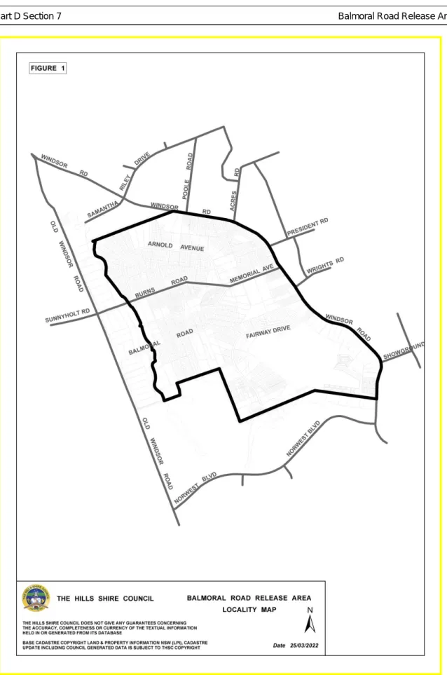
Draft Part D, Section 7 – Balmoral Road Release Area
CONCLUSION AND NEXT STEPS
ATTACHMENTS
Draft Part D Section XX – Bella Vista and Kellyville Station Precincts of The Hills Development Control Plan 2012 (54 pages)
Draft Part D, Section 7 – Balmoral Road Release Area of The Hills Development Control Plan 2012 (58 pages)
Land to which this Section applies
Various pockets of non-SSDA land also have limited development potential, either due to current planning controls, proximity to metro and arterial roads, fragmented land ownership or ecological constraints due to proximity to the Elizabeth Macarthur Creek Riparian Corridor. Controls under this DCP are applicable to land not covered by the SSDA, which is mainly
Purpose of this Section
The Urban Design Guidelines, approved by the Department of Planning and Environment (the Department) as part of the SSDAs, will guide future development on the applicable SSDA land (as shown in Figure 2).
Relationship to other Sections of the DCP
Approval Pathway for SSDA Land
Vision
Development Principles
Source: Urban design report submitted in conjunction with Bella Vista SSDA by Hassell, 2019) Employment results. Source: Urban planning report submitted in conjunction with Bella Vista SSDA by Hassell, 2019) Making Cities.
Bella Vista and Kellyville Station Precincts
Character Areas
The Elizabeth Macarthur Creek Corridor will be a major defining feature that will be showcased by future developments within the district. Source: Urban Design Report submitted in conjunction with the Bella Vista SSDA prepared by Hassell, 2019).
Structure Plans and Key Elements
Land Use Bella Vista: Residential areas include a higher density building form in the southern non-SSDA areas, transitioning to lower grade apartments further north towards Memorial Avenue and further east towards the Elizabeth Macarthur Creek corridor. Lower apartment buildings up to 6 storeys located towards Memorial Avenue and the Elizabeth Macarthur Creek Corridor.
Movement Network and Design
Source: Urban Design Guidelines submitted in collaboration with Kellyville SSDA prepared by SJB Urban). Source: Urban Design Guidelines submitted in collaboration with Kellyville SSDA prepared by SJB Urban).
Public Domain
Examples of Public Domain Elements – Planting character and seating (left), Path character (centre) and recreational spaces (right). Source: Urban Design Report submitted in collaboration with Bella Vista SSDA prepared by Hassell, 2019).
Integrated Water Management
Rainwater tanks should be used for outdoor uses and other purposes such as washing machines and laundries. Rainwater tanks must be fitted with potable water flow fills with a backflow prevention device in accordance with Sydney Water requirements.

Subdivision and Earthworks
Mean SD Mean SD Mean SD Mean SD Mean SD Mean SD. all values expressed as log10 mg/l) General urban.
Cut and Fill
All cut and fill works shall comply with Council Design Guidelines, Subdivisions/Developments and Works Specifications, Subdivisions/Developments. Deposited areas shall be suitably compacted and stabilized with compaction testing to verify that compaction was achieved in accordance with Council requirements.
Ecologically Sustainable Development
The relevant provisions of the Council's DCP on flood controlled land should be applied in the recharge areas, with reference to the integrated water management section of this DCP. Embankments and retaining walls should be landscaped to reduce erosion and provide adequate screening.
Ecology and Riparian Corridors
Source: Bella Vista Biodiversity Assessment Report prepared by WSP submitted with the Bella Vista SSDA). Note: the Affected Riparian Zone (shown in green above) only relates to SSDA land within Bella Vista.
Safety and Security
Heritage (Aboriginal and European)
Wind
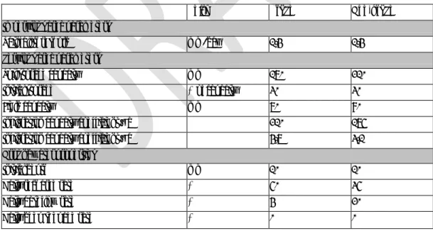
In open areas to which people have access, the maximum annual gust speed does not exceed 23 meters per second. In stationary long-term exposure areas, such as outdoor restaurants, the maximum annual gust velocity should not exceed 10 meters per second.
Site Requirements
The orderly development of the isolated site can be achieved consistent with the provisions of The Hills LEP and DCP. The development of an isolated site must not detract from the character of the streetscape and is to achieve a satisfactory level of amenity including solar access, visual and acoustic privacy.
Setbacks (Building and Upper Level)
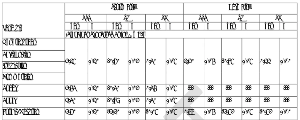
Development adjacent to a road not identified in Figure 26 is set back 5m from the property boundary. Setbacks on the top floor Floors above the 4th floor must be at least 5 meters behind the front building line.
Open Space and Landscaping
The 3rd and 4th floors for these developments will be 2 m behind the construction line. Native ground covers and grasses should be used in garden beds and path surrounds (terrain should be limited to usable outdoor areas).
Built Form Design
No more than 25% of the total number of apartments (to the nearest whole number of apartments) contained in the project shall be studios or one-bedroom apartments or both. At least 20% of the total number of dwellings (to the nearest whole number of dwellings) contained in the development must be dwellings of 3 or more bedrooms.
Streetscape and the Public Domain Interface
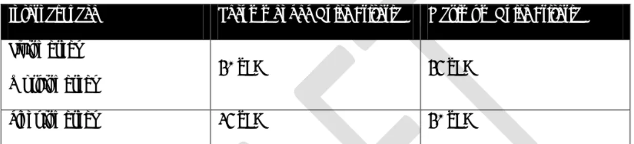
The minimum floor-to-floor height of an above-ground parking level should be 4.5m at ground level and 3.6m at any above-ground parking level to facilitate the conversion of above-ground car parking to other uses. Habitable rooms in multi-unit residential development and mixed-use development must have a minimum floor-to-ceiling height of 2.7m.
Development Adjoining the Elizabeth Macarthur Creek Riparian Corridor
The first 5 m of all setback areas adjacent to and perpendicular to the river corridor shall include soft landscaping. Levels above the 4th floor shall be set back 5 m behind the building line facing the river corridor.
Residential Uses on Ground and First Floors
Solar Access and Overshadowing
Adaptable housing
Noise
The provisions of the National Policy on Spatial Planning (Transport and Infrastructure) 2021 (formerly the National Policy on Spatial Planning (Infrastructure) (Infrastructure) 2007) and the Interim Development Directive Near Railway Corridors and Busy Roads must be taken into account to minimize the effects of busy roads and railway corridors on housing and other sensitive developments. The provisions of the National Policy on Spatial Planning (Transport and Infrastructure) 2021 (formerly the National Policy on Spatial Planning (Infrastructure) (Infrastructure) 2007) and the Interim Development Directive Near Railway Corridors and Busy Roads must be taken into account to minimize the effects of busy roads and railway corridors on housing and other sensitive developments.
Wind
Development applications must demonstrate how buildings meet the noise criteria set out in Table 6. Bella Vista and Kellyville Station Areas - Development Control Plan. open space and private open space), the maximum annual gust speed must not exceed 13 meters per second;.
Parking Rates and Access
Development applications are to demonstrate how to access the car share parking space(s), including where access is through a security gate. A covenant must be registered with the strata plan indicating any car share parking space.
INTRODUCTION
- LAND TO WHICH THIS SECTION OF THE PLAN APPLIES
- AIM AND OBJECTIVES OF THIS SECTION OF THE DCP
OBJECTIVES AND
DEVELOPMENT CONTROLS
DEVELOPMENT CONTROL PLAN MAP
SITE ANALYSIS O BJECTIVES
Presentation of how the locations and dimensions of plots and dwellings respond to topography, site characteristics and how they achieve solar orientation; and. Demonstration of how the locations and dimensions of plots and dwellings respond to topography, site constraints and achieving solar orientation.
The results of the tree survey/evaluation and identification of trees and/or woodland to be protected and/or removed.
SUBDIVISION – ALL ZONES
- TREE AND BUSHLAND PROTECTION
- RESIDENTIAL DEVELOPMENT SITES
- D WELLINGS
Protective fencing To protect trees and shrubs, fencing must be installed to prevent damage. Such earthworks may extend into the proposed allotments to provide suitable vehicle access to the identified construction platform referred to in Section 3.2.1.3. b) Vegetation and topsoil must not be removed or disturbed in areas outside the above areas of the proposed construction.
ROADS
- LOCAL ROAD HIERARCHY O BJECTIVES
- ROAD DESIGN AND CONSTRUCTION
The route and geometry of all collector roads must be designed for the efficient and unhindered movement of buses. A temporary public road shall be constructed on a minimum of two (2) residential lots, except as noted below;.
STORMWATER
- STORMWATER MANAGEMENT O BJECTIVES
- STORMWATER QUALITY
The development of the release area provides an opportunity to implement Total Catchment Management principles. To protect downstream water during construction activities within the release area. ii) To assist in the long-term protection and improvement of stream health.
PROVISION AND LOCATION OF UTILITIES
The trunk drainage system for the release area is an integrated system, owned and managed by Sydney Water. Part D Section 7 Balmoral Road Clearance Area. h) Pipes and channels through bushy areas and areas with significant plant cover should be avoided.
PUBLIC RECREATION, TRUNK DRAINAGE AND RIPARIAN
- PUBLIC RECREATION O BJECTIVE
Where this cannot be avoided, pipes should be laid by hand using small machinery, causing minimal disturbance to vegetation and exposed rock points. i) Development is to have a water supply for fire fighting purposes in accordance with the NSW Rural Fire Service's "Planning for Bushfire Protection 2006" or as amended. j) Consent from the relevant electricity authority is required for all development applications where the property is affected by electricity services. k) Road edge widths must be in accordance with Table 1.
BUILDING DESIGN – ALL ZONES
- DWELLINGS
- C UT A ND F ILL
- MULTI DWELLING HOUSING
- S TORMWATER M ANAGEMENT O BJECTIVES
- RESIDENTIAL FLAT BUILDINGS The following development control provisions relate
- B UILDING H EIGHTS
- S TORMWATER M ANAGEMENT O BJECTIVES
- B7 BUSINESS PARK ZONE
- I NDUSTRIAL A ND C OMMERCIAL B UILDINGS
- EXHIBITION VILLAGE
- MEMORIAL AVENUE VILLAGE CENTRE, KELLYVILLE
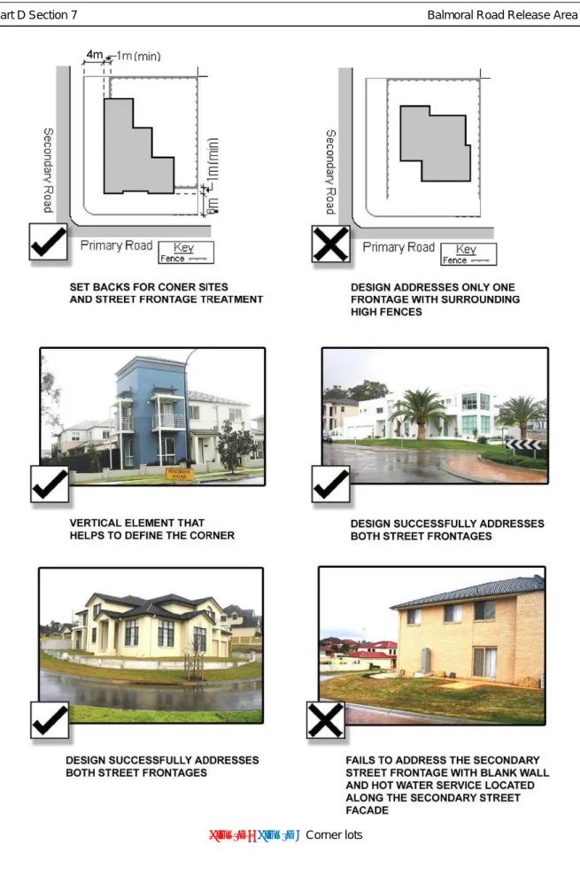
On corner lots, a minimum of three of the following design elements should be included along the secondary frontage:. This section should be read in conjunction with other relevant sections of The Hills DCP, including Part D, Section 7 – Balmoral Road Release Area and Part B, Section 6 – Business.
SPECIAL PROVISIONS
- DEVELOPMENT WITHIN VICINITY OF NORTH WEST RAIL LINK
- LAND ADJOINING EXISTING GOLF COURSE
- EXCISION OF EXISTING DWELLINGS Council will permit the excision of existing dwellings
- SALINITY
- LAND IN VICINITY OF EXISTING RETIREMENT VILLAGE
- NOISE ATTENUATION
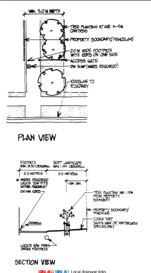
- LANDSCAPE CORRIDORS
- PUBLIC ROAD CLOSURES
- ABORIGINAL HERITAGE
- LAND ADJOINING WINDSOR ROAD (e) Existing properties fronting Windsor Road and
- LAND ADJOINING OLD WINDSOR ROAD
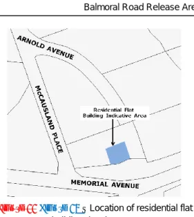
Any development within the area marked on the DCP map as being upstream of the existing castle. This section of the Development Control Plan applies to land at 6 McCausland Place, Kellyville (Figure 10, Figure 12).
BUDGET REVIEW AS AT 30 APRIL 2022OC INFO THEME: PROACTIVE LEADERSHIP
MEETING DATE: 24 MAY 2022
GROUP: FINANCE AND ORGANISATIONAL PERFORMANCE
AUTHOR
ACTING MANAGER BUDGETING, INTEGRATED PLANNING &
REPORTING
SACHA THIRIMANNE
RESPONSIBLE OFFICER
GROUP MANAGER FINANCE & ORGANISATIONAL PERFORMANCE
CHANDI SABA
Recurrent Operations
Capital Works
Maintain a strong financial position that supports the delivery of services and strategies and ensures long term financial sustainability
Outcome
REPORT
The transfer from the internal limits represents funds that were quarantined in previous years by Council resolutions and are now used for expenditure relating to the current year. A carryover from external restrictions represents funds that have been quarantined by legislation in previous years (eg Section 7.11 Development contributions and grants) that are now being used for current-year expenditure or current-year income.
Income – Decrease $1.56m
Waves Aquatic & Fitness Centre Income – Decrease $81m
Transfer from Prior Years Income – Increase $252k
Expenditure – Net Increase $2.14m as detailed below
Fringe Benefit Tax – Decrease $115k
Waves Aquatic & Fitness Centre Expenditure – Decrease $1.57m
Recurrent Project Savings – Decrease $485k
Road Safety Projects – Increase $25k
MOVEMENT IN RESERVES
Transfer to Reserves – Increase $585k
The net increase in Capital works funding (excluding VPA) of $1.3m compromises
New Projects: $1.3m
Increased funding for an Existing Job: $14k
Hills of Carmel VPA (CP15) $2.7m
Jord forbundet med New Main Road - Mt Carmel Road - Windsor Road til Killarney Chain of Ponds.
Gap Funding
Delegation given to the General Manager write-off of interest costs for a period of six (6) months on outstanding interest. The Council authorizes the Chief Executive to amend, cancel or enter into new leases as necessary in accordance with the timeframes for the December local elections on terms consistent with the current leases to facilitate the December local government elections.
Write-off of Rates Interest Charges
Rent Relief
- Income & Expenditure by Program
- Operating Statement (IP & R requirement)
- Cash & Investments
- Section 7.11 & 7.12 Funds Statement
- Capital Works Expenditure and Comments on Variations Page 26 Key Performance Indicators
- Listing of Contracts & Other Expenses
The Council's Group Manager – Finance and Organizational Performance, as Responsible Accounting Officer, advises that the Council's projected financial position is satisfactory. Furthermore, the investments presented in Appendix 1 page 5-6 are made in accordance with the Act, Regulation and the current Investment Policy of the Council.
The Hills Shire Council
PROPERTY DEALING RELATING TO DEVELOPMENT MATTER THEME: VALUING OUR SURROUNDINGS
GROUP: DEVELOPMENT AND COMPLIANCE AUTHOR: SUBDIVISION TECHNICAL OFFICER
HARLEIGH HAINES RESPONSIBLE
OFFICER
MANAGER – SUBDIVISION AND DEVELOPMENT CERTIFICATION BEN HAWKINS
LINK TO HILLS SHIRE PLAN Strategy
The Shire’s natural and built environment is well managed through strategic land use and urban planning that reflects our values and aspirations
Outcomes
- The release of two drainage easements from the title of Lot 128 DP 250610, 22 Chapman Avenue, Castle Hill and Lot 21 DP 255722, 23 Dawes Avenue, Castle Hill
- Locality Plan (1 page)
- Plan of Subdivision Showing Consolidation and New Easement (1 page) 3. DP 250610 and DP 255722 Showing Existing Easements (2 pages)
- LOCALITY PLAN
Development Consent 192/2019/JP has been approved for the construction of residential apartment buildings over 16-26 Chapman Avenue and 17-27 Dawes Avenue. Part of that approval included moving the wells and pipes (and easement) through the site to the northwest boundary of 26 Chapman Avenue and 27 Dawes Avenue and along both roads so that it no longer dissected the site in the middle.
EASEMENT
LOCAL APPROVALS POLICY 2022 DOC INFO THEME: VALUING OUR SURROUNDINGS
GROUP: DEVELOPMENT AND COMPLIANCE AUTHOR
ENVIRONMENTAL HEALTH COORDINATOR DANIEL GIFFNEY
GROUP MANAGER – DEVELOPMENT & COMPLIANCE CAMERON MCKENZIE
- The draft Local Approvals Policy 2022 be placed on public exhibition in accordance with the requirements of the Local Government Act
- A further report be made to Council at the conclusion of the exhibition period
- Ensure Council is accountable to the community and meets legislative requirements and support Council’s elected representatives for their role in the community
- Effective regulatory strategies, local laws, and compliance programs, manage public health and the impact of new and existing development on the community
The LAP will also provide greater certainty about what information is required to be submitted as part of the application and will inform clients of what will be considered in the assessment of the application.
EXISTING SECTIONS Solid fuel or oil fuelled heater
There has been an increase in the number of mobile food vendors wishing to trade within the Shire over the past 10 years, particularly since the COVID-19 pandemic. Prior to inclusion in the LAP in 2016, there were limited criteria by which mobile food vendors could be regulated.
NEW SECTIONS
CONCLUSION
Draft Local Approvals Policy 2022 (55 pages)
Exemptions as listed in Appendix 8 – Deliver a public speech or hold a religious service or public address on community land. Criteria as listed in Appendix 8 – Deliver a public speech or hold a religious service or public speaking on community grounds.