Ministry of Environment and Water Resources (formerly Ministry of Environment and Heritage). This is in addition to the existing 120 heavy vehicle movements on the South Coast Highway section. Indication of the requirement for reference to regulatory authorities or other approvals for the project; And.
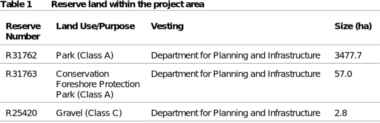
Details on the land use/purpose of the three reserves near the project area are provided in Table 1. The project is located in the Esperance Plains biogeographical region which is part of the Southern Botanical Province.
Vegetation Condition
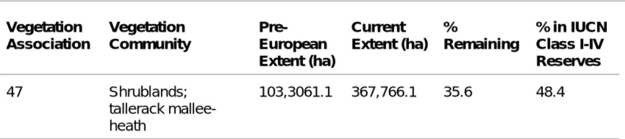
Least Concern: >50% pre-European size exists and is subject to little or no deterioration in most of this area. However, consultation with Ms Kym Lewis of the Bunbury DEC Office (Native Vegetation and Wetland Branch) confirmed that based on the vegetation community present in the study area and its remaining size (35.6%), it is not considered to be under threat. Therefore, cutting vegetation proposed for the project is not considered to contradict the EPA's recommendations in Position Statement No.
4 Good Vegetation structure significantly altered by very clear signs of multiple disturbance, retains basic vegetation structure or ability to regenerate. The structure of the vegetation is no longer intact and the area is completely or almost devoid of native species.
Threatened Ecological Communities
Flora
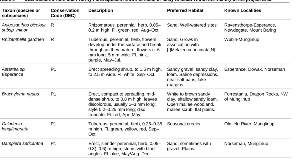
Expected Significant Flora
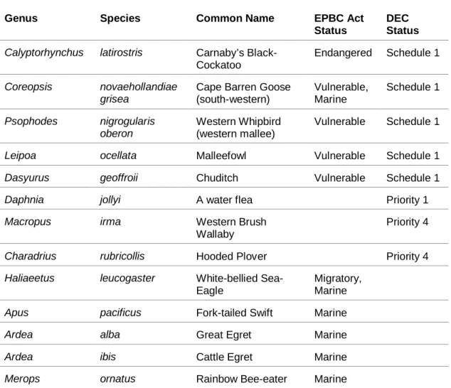
Searches of the DEC flora database and Western Australian Herbarium (WAHERB) records show that 2 species of Declared Rare Flora (DRF) and 20 species of Priority Flora are known to occur or likely to occur in the vicinity of the project area. Taxa known from one or more (generally <5) populations that are under threat, either due to small population numbers, or being on lands under immediate threat, e.g. Taxa known from one or several (generally <5) populations, at least some of which are not believed to be under immediate threat (ie not currently endangered).
Taxa known from several populations and taxa not believed to be under immediate threat (ie not currently endangered), either because of the number of known populations (generally >5), or because of the number of populations known to be large, and either widespread or protected. Stokes Inlet, Gibson Desert, Boorabbin, Jilbadji, Fitzgerald River NP, Queen Victoria Spring Eucalyptus famelica P3 Mallee, 1.5–4 m tall, bark smooth.
Site Flora identified during the Biological Survey
Site Significant Flora Declared Rare Flora
Ongoing road and shoulder maintenance requirements will affect the presence of this species. Eucalyptus ?sheathiana: The identification of this species remained uncertain after comparison with known WAHERB specimens. Initial field identification placed this taxon in Eucalyptus phenax, which is known from the area, however, on closer examination it was considered to be closer to E.
This specimen was considered distinct from both species by the lack of a pointed mucro on the leaf tip. South Coast: The genus Schoenus is currently undergoing revision, and a number of taxa have yet to be formally identified.
Weeds and Introduced Species
P3 Control infestations in a manner that prevents the spread of seeds or plant parts within and from the property onto or into livestock, feed, grain, vehicles and/or machinery. P4 Prevent the spread of infestation from the property to or in livestock, feed, grain, vehicles and/or machinery. Two weed species recorded from the study area are declared plants: Captulipan (Moraea sp.) and Bride's creeper (Asparagus asparagoides).
Both species were considered a normal component of the canopy only in the affected areas of lane 6. Category: P4: Location: For the municipal districts of Albany (C), Augusta-Margaret River (S), Boddington (S), Boyup Brook (S), Bridgetown-Greenbushes (S), Brookton (S), .
Dieback and other diseases or pathogens
Fauna
- Expected Fauna
- Site Fauna
- Significant Fauna Species
- Habitat Assessment
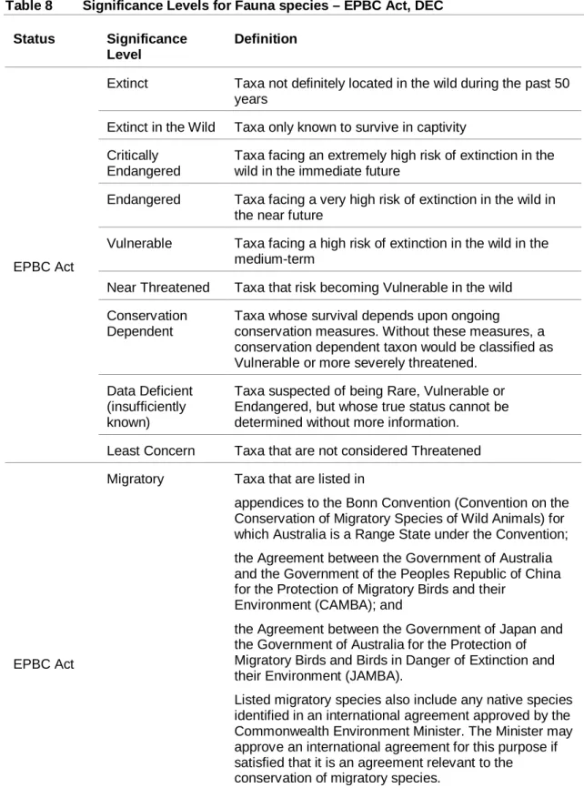
Taxa are at extremely high risk of becoming extinct in the wild in the near future. Endangered taxa threatened with extinction in the wild in the near future. Taxa not considered endangered, but subject to a specific conservation program, the cessation of which would result in the species becoming endangered within five years.
There are also a number of wetlands and small dams scattered around the study area. The project area is considered to contain some significant disruptions in habitat connectivity, with large areas of cleared (agricultural) land adjacent to the study area.
Heritage
European Heritage
A large area of habitat is present north of Crossing Lane 5 that connects to the Young River. Fauna corridors and habitat connectivity are important to allow animals to move between available resource areas. Such corridors are important for terrestrial and aerial fauna, providing cover, resources and connecting areas suitable for resting and breeding.
Habitat corridors are important in areas where extensive clearing has occurred to help overcome the effects of habitat fragmentation. These corridors help maintain genetic diversity through connection of gene pools, allowing recolonization of disturbed areas and the provision of habitat. Where contiguous woodland areas cannot be maintained, a connection can still be maintained by "stepping stones", which are isolated patches of vegetation close enough together to allow certain species to move between them.
Birds often require "flyways," grassy areas along a shrub corridor that they can use to move between habitat areas. One complete habitat in good condition and associated faunal corridor (Young River) is located at the western end of the Passing Lane 6 study area. However, the Main Roads Environment Officer has advised that clearance will not be undertaken prior to SLK 401.4; therefore, the vegetation in good condition in this section would not be affected.
Aboriginal Heritage
The results of this study confirmed that the above recorded sites will not be affected by the proposed project (Goode and Harris, 2005). The report includes the Aboriginal community's recommendation to avoid impacting the Young River valley as it has mythological significance and previously reported to contain burials.
Environmental Aspects
Key Environmental Aspects
Assessment of Aspects and Impacts
Additional records of the aforementioned Priority 3 species, Thomasia pygmaea, were within the study area. Clearing boundaries should be clearly marked with operations undertaken to minimize clearing and avoid disturbance to native vegetation beyond clearing boundaries. Clearing boundaries should be clearly marked with operations undertaken to minimize felling and avoid disturbance to native vegetation beyond clearing boundaries.
The introduction and spread of erosion in undisturbed areas of natural vegetation will affect the structure of the native plant community. The Main Roads Term Network Contractor should be informed of the presence of this weed to ensure that it is eradicated and not spread along the way. Aspect evaluation of potential impact recommendations Aboriginal heritage The desktop search in the DIA Heritage Inquiry System.
Further research needs to be done to determine the source of this water and whether it is from a natural spring or a broken pipe, as this could affect the integrity of the road formation over time. Salinity Given the nature and size of the proposed project, this aspect is not considered to be a significant problem. Acid sulphate soils Application of the WAPC (Planing Bulletin 64) self-assessment indicates that no further soil investigation is required for the proposed project.
If water is observed flowing from a point within the toe of the roadside drain requiring dewatering, the WAPC self-assessment should be performed again. Assessment of the potential impact aspect Recommendations Public safety and risk The construction phase of the project may cause some publicity. Three reserves are located outside the study area and their mapped locations according to the proposal are such that impact on them is unlikely.
Assessment Against Clearing Principles
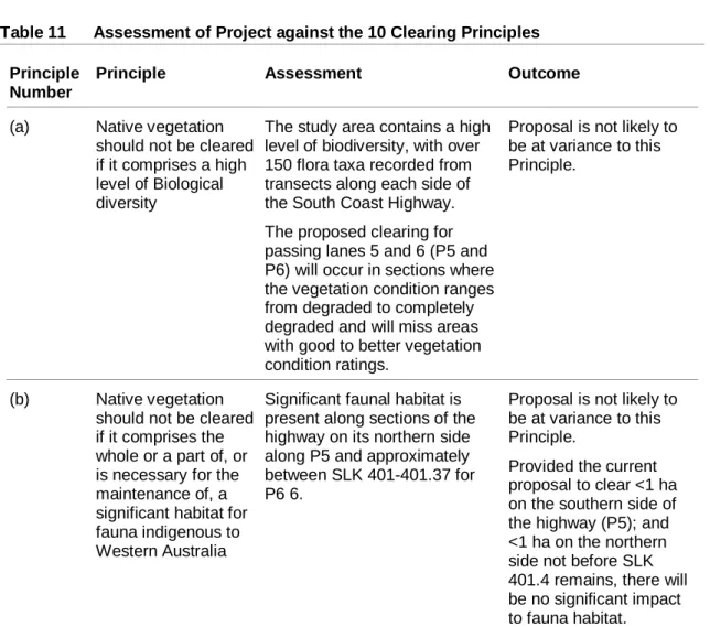
During the biological survey, no known Declared Rare Flora (DRF) species were recorded in the study area. The EPBC Act and DEC search showed that there are no TECs in the project area. No work or development is planned near the Young River or its tributaries; therefore no effects are likely.
This project facility is considered unlikely to cause or increase the risk of significant land degradation. Native vegetation should not be cleared if the clearing of vegetation is likely to have an impact on the environmental values of any adjacent or nearby conservation areas. The proposed nominal clearance in areas of degraded and fully degraded vegetation adjacent to the existing highway will not affect any conservation areas.
This proposed clearing of approximately 2 ha of native vegetation along the existing highway is not likely to cause surface or groundwater degradation. Main roads will ensure that there is no deterioration of surface or ground water quality by adhering to a project specific EMP. The scope of this project and the limited scope of the proposed work is unlikely to cause or exacerbate the risk of flooding in adjacent areas.
Assessment against the 10 Clearing Principles demonstrates that the current clearance proposed for the road project can be performed in accordance with the Main Roads Statewide project.
Consultation
Requirements for Approvals
Passing Lane 5. SLK 399 Looking East
Passing Lane 5, Location 32850E, 6262920N, looking east
Passing Lane 5, SLK 399 looking west. Note Rehab area on south side (left)
Passing Lane 6: SLK 401, Looking east
Passing Lane 6: Location 330950E, 6262920N, Looking west
Passing Lane 6: Location 330950E, 6262920N, Looking east
Passing Lane 6: Location 333190E, 6263480N, Looking north at small patch of remnant vegetation
Passing Lane 6: SLK 405, looking west
Observed Flora List, Passing Lanes 5 and 6, South Coast Highway
Observed Fauna List, Passing Lanes 5 and 6, South Coast Highway
The spatial information captured in the site file is considered reliable because of the way it was captured. The spatial information captured in the location file is considered unreliable due to errors in spatial data capture and/or quality of the reported spatial information. There are Aboriginal sites that are not listed on the Register of Aboriginal Sites, and some registered sites may no longer exist.
The AHA protects all Aboriginal sites in Western Australia whether they are registered or not. Index coordinates are indicative locations and do not necessarily represent the center of sites, especially for sites with a "closed" or "vulnerable" access code. Copyright in the information contained herein is and shall remain the property of the State of Western Australia.
This includes but is not limited to information from the Aboriginal Areas Register established and maintained under the Aboriginal Heritage Act 1972 (AHA). Copyright for the basemap information remains at all times owned by the Commonwealth of Australia, Geoscience Australia - National Mapping Division. Copyright Aboriginal Land Claim, Local Government Authority, Mining Lease Boundaries remains the property of the State of Western Australia at all times, all rights reserved.