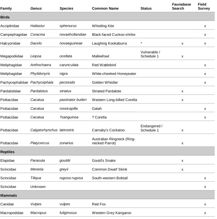
Fauna database search in a 5 km radius of the site) 56 Table 16 Fauna species that can occur at 92.60 to 95.9 SLK. Most of the vegetation across the site was considered to be a mosaic, i.e. transition between the different vegetation types. Signs of fox and kangaroo use of the site were recorded during the field survey.
GHD Pty Ltd (GHD) was commissioned by Main Roads WA to prepare an Environmental Impact Assessment and Environmental Management Plan (EIA and EMP) for a proposed road upgrade of sections of the Brand Highway. Where the outcome of the PEIA indicated that the proposed clearance "may be inconsistent or seriously inconsistent with one or more of the clearance principles", Main Roads WA must undertake an EIA (DEC, 2005). An assessment of the site's vegetation type and condition and a review of the significance of the vegetation communities on the site.
An assessment of the possible presence of any pests and plant diseases in the country; An inventory and review of vertebrate fauna species in the study area, especially protected fauna species.
Need for the Proposal
Proposal Schedule
Existing Environment
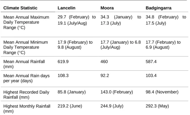
- Climate
- Geology and Soils
- Acid Sulphate Soils
- Rivers and Wetlands
- Groundwater
- Reserve and Conservation Areas
- Contaminated Sites
- Flora and Vegetation
- Background
- Field Survey Methods
- Vegetation Description
- Vegetation Condition
- Significance of Vegetation
- Threatened Ecological Communities
- Environmentally Sensitive Areas
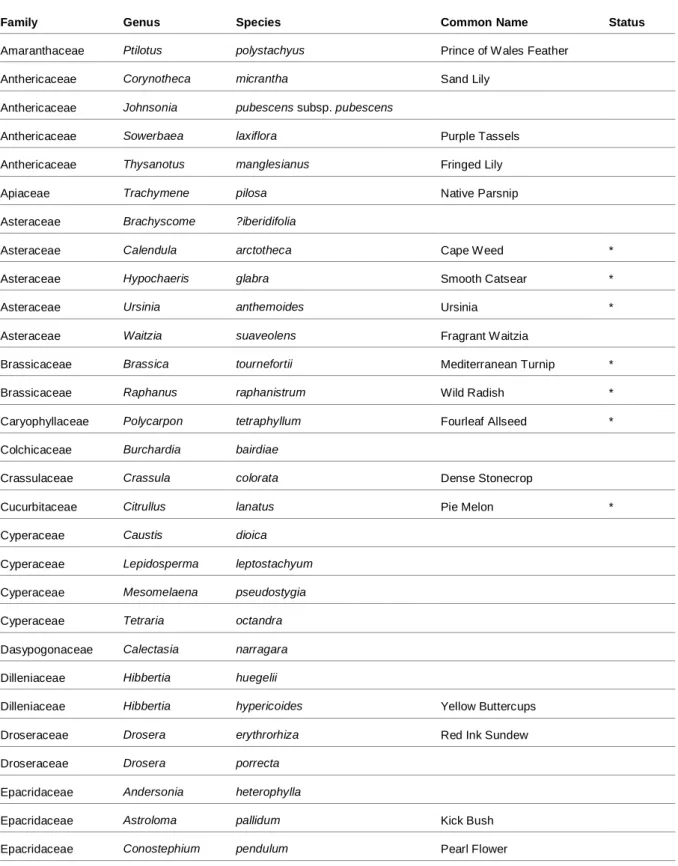
- Flora Species
- Significant Flora Species
- Weeds
- Plant Pests and Diseases
- Fauna
- Field Survey Methods
- Fauna Species
- Significant Species
- Introduced Species
- Habitat Value
- Habitat Linkages
Several permanently and seasonally flooded wetlands occur approx. 1 km west of the site. No wetlands described in the Environmental Protection (South West Agricultural Zone Wetlands) Policy 1998 or listed under the Ramsar Convention (1971) occur near the site. There are no protected areas near the locality (Ministry of Land Information, 2006).
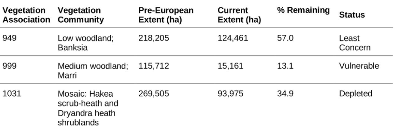
6 zone map does not identify any local parks and recreation reserves near the site. There is a parking bay in the northern part of the site, and the adjacent vegetation has changed the structure somewhat. Vegetation types known to occur near the site are outlined in Table 4.
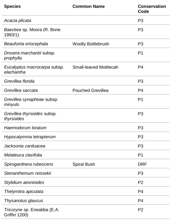
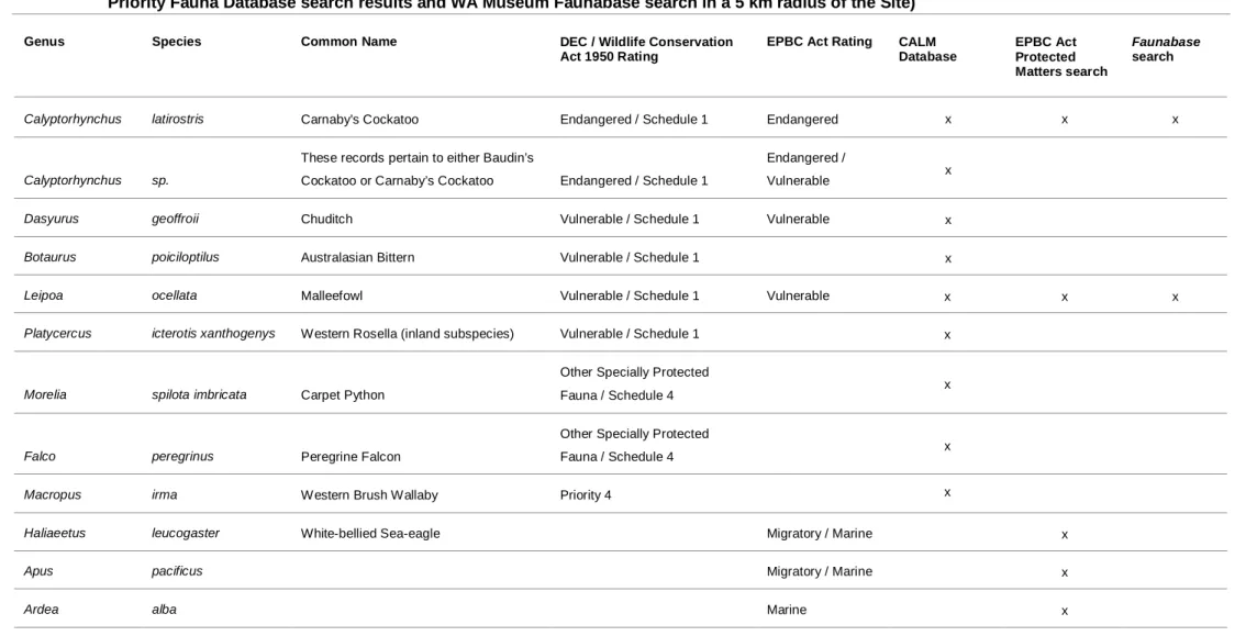
However, a Priority Ecological Community is known to occur 20 km west of the site. Additionally, a number of important species have been recorded in the general vicinity of the site (Table 8, Appendix B).
Social Environment
Surrounding Land Use
Aboriginal Heritage
European Heritage
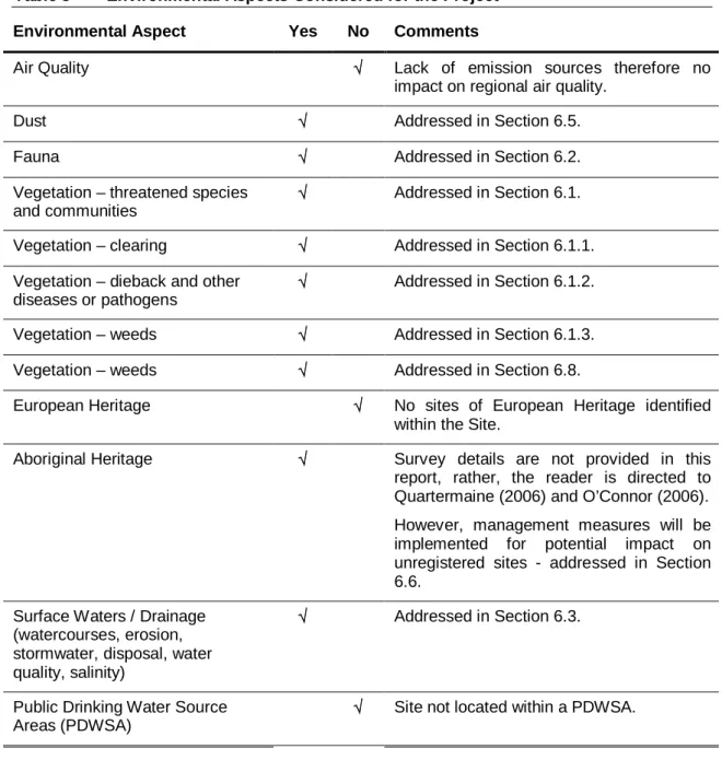
Environmental Aspects
These are not expected to be affected by the Project, but management measures are addressed in Section 6.3. Visual impacts √ Minimal impact due to the remote location of the site and the fact that a road already exists on the site. The Project is not expected to require deep excavation, it is considered unlikely that acid sulfate soils will be encountered during the Project.
Reserves and conservation areas √ No reserves or conservation areas are within or adjacent to the site.
Environmental Impacts and Management
- Flora and Vegetation
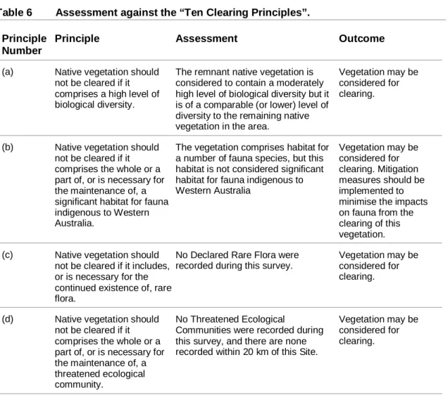
- Assessment Against the “Ten Clearing Principles”
- Disease Management
- Weed Management
- Fauna
- Drainage
- Groundwater
- Dust
- Aboriginal Heritage
- Public Safety
- Fire Management
- Hydrocarbon and Chemical Storage
- Waste Management
Vegetation can be considered for clearing. g) Native vegetation should not be cleared if the clearing of the vegetation is likely to cause appreciable soil degradation. Partial site clearing is likely to cause some, but not significant, soil degradation of adjacent bushland. Vegetation can be considered for clearing. i) Natural vegetation should not be cleared if the clearing of the vegetation is likely to cause deterioration in the quality of surface or ground water.
Appropriate management plans should mitigate potential impacts. j) Native vegetation must not be cleared if the clearing of vegetation is likely to cause, or. This EIA has determined that the proposed clearing is not inconsistent with any of the "Ten Clearing Principles" and is not within an ESA, therefore, the Site may be considered for clearing. However, on-site cleanup will be minimized and managed in accordance with the draft PMM provided in Appendix E.
There was no indication of the occurrence of in-zone dieback typically indicated by the death patterns of susceptible plants. There is some suitable breeding habitat for Carnaby's Cockatoo in the general region, but the site does not contain suitable breeding trees for this species. Habitat assessment There are no permanent wetlands within the site and this species would be very unlikely to occur in the site.
Habitat Assessment The site occurs within the historical range of this species, but it is no longer known to occur in the area. Habitat Assessment This subspecies is generally found in the Wheat Belt (east of Brand Highway) and is very unlikely to occur at the site. Habitat assessment This species occurs in small numbers in the general area of the site and there is a chance of occurring on the site, but the minimal nature of the clearing and the presence of surrounding habitat would not affect their survival in the area.
Habitat Assessment The site is at the northern extent of the known Western Brush Wallaby range. This species also requires large patches of vegetation to sustain its populations and is unlikely to occur in the area. The site does not contain any wetlands listed under the Environmental Protection Policy (South West Agricultural Area Wetlands) 1998 or the Ramsar Convention (1971), but several permanently and seasonally flooded wetlands occur approximately 1km west of the site.
Environmental Management Plan
Environmental Monitoring and Compliance
- Environmental Management and Quality Plan
Consultation
Conclusions
The Site contains vegetation which is in very good condition, and which will offer high value as faunal habitat. However, the extent of clearing required for this project is minor and the majority of the vegetation in the road reserve will be preserved. Impacts on the remaining vegetation and on faunal species on the Site can be managed through appropriate mitigation measures, as detailed in the EIA.
The amount and type of settlement required for this Project has been assessed as not deviating significantly from any of the "Ten Settlement Principles".
Limitations
Survey Limitations
Report Limitations
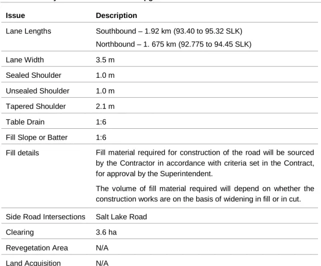
SLKSALT LAKE RD
SLK94.00 SLK
Marri Open Woodland
Vegetation Community Descriptions
Banksia Low Woodland
Scrub-heath
Minimal evacuation of the transitional community of Marri Woodland is required, this community is considered to be poorly represented regionally. Fauna Due to the minimal logging, it is unlikely that there will be a significant impact on the long-term survival of endangered species that may be present in the project area. The contractor carrying out the construction will be aware of environmental considerations and its obligations, to ensure minimal impact on the environment.
The employees involved in the project will be aware of environmental concerns and their obligations to ensure minimal environmental impact. Trees of special habitat importance that must be preserved will be clearly marked before clearing begins. Limit the movement of machinery and other vehicles to the boundaries of the areas to be cleared.
All machines will be shut down during periods of extreme fire hazard as advised by the DEC of Main Roads WA or the Shire of Gingin; And. Smoking on the premises is controlled and all cigarettes are disposed of in a designated container. All glass (and other waste) is collected and removed daily.
Construction Contractor Construction 9.3 The work site will remain in a safe condition at the end of each working day. The rise of dust will be kept to a minimum, which will reduce inconvenience for road users and the risk of impacts on the surrounding vegetation and public safety. The PTU will be submitted to the Construction Manager for approval within twenty-eight days of the award of the contract or within ten days of obtaining possession of the land or prior to commencement of work, whichever is earlier.
Any non-conformity will be dealt with at the earliest opportunity, while the non-conformity and any corrective actions will be detailed in the relevant construction supervisor's documentation. Ms Lauritsen advised that it will be necessary for MRWA to apply for an evacuation permit as the previous exemption that applied to this activity has now expired, but informed GHD of MRWA's new evacuation permit. Ms Broun stated that the outcome of the studies may affect the location of the overtaking lanes and will be necessary information in case the proponent applies for a license to take DRF.
The vegetation survey should include any areas that will be affected by the works, including the site itself, temporary access tracks, machinery parking areas and new maintenance areas resulting from changes in road surface width. Mr Connell gave details of the passage of gas pipeline infrastructure near the site.