Outdoor Signs and Advertising
- Scope of Section
- Traffic Signs on Roads
- Permitted Activities (Traffic Signs on Roads)
- Outdoor Signs in Residential Zone
- Permitted Activities (Outdoor Signs in Residential Zone)
- Discretionary Activities (Outdoor Signs in Residential Zone)
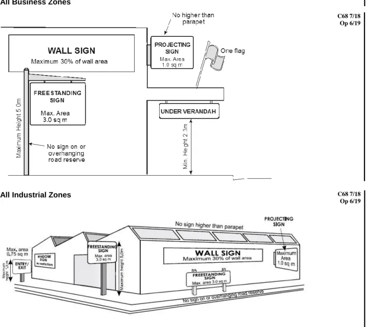
- Outdoor Signs in Business and Industrial Zones
- Permitted Activities (Outdoor Signs in Central Business, Commercial, Mixed Business, Tourist
- Restricted Discretionary Activities (Outdoor Signs in Central Business, Commercial, Mixed
- Outdoor Signs in the Rural 1, Rural 2, Rural 3, Rural
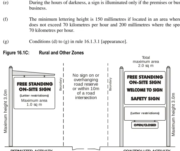
- Permitted Activities (Outdoor Signs in Rural 1, Rural 2, Rural 3, Rural Residential,
- Controlled Activities (Outdoor Signs in Rural 1, Rural 2, Rural 3, Rural Residential,
- Controlled Activities (Outdoor Signs in Rural 1, Rural 2, Rural 3, Rural Residential,
- Restricted Discretionary Activities (Outdoor Signs in Rural 1, Rural 2, Rural 3, Rural
- Temporary Signs in All Zones
- Permitted Activities (Temporary Signs)
- Restricted Discretionary Activities (Temporary Signs)
- Principal Reasons for Rules
The erection of an outdoor sign in the Residential Zone that does not meet the permitted conditions of rule 16.1.3.1 is a discretionary activity, if it meets the following condition: a). Any temporary sign that does not meet the permitted conditions of rule 16.1.6.1 is a limited discretionary activity.

Transport (Access, Parking and Traffic)
Scope of Section
Land Use
- Permitted Activities (Land Use – Vehicle Access Considerations)
- Permitted Activities (Land Use – Traffic)
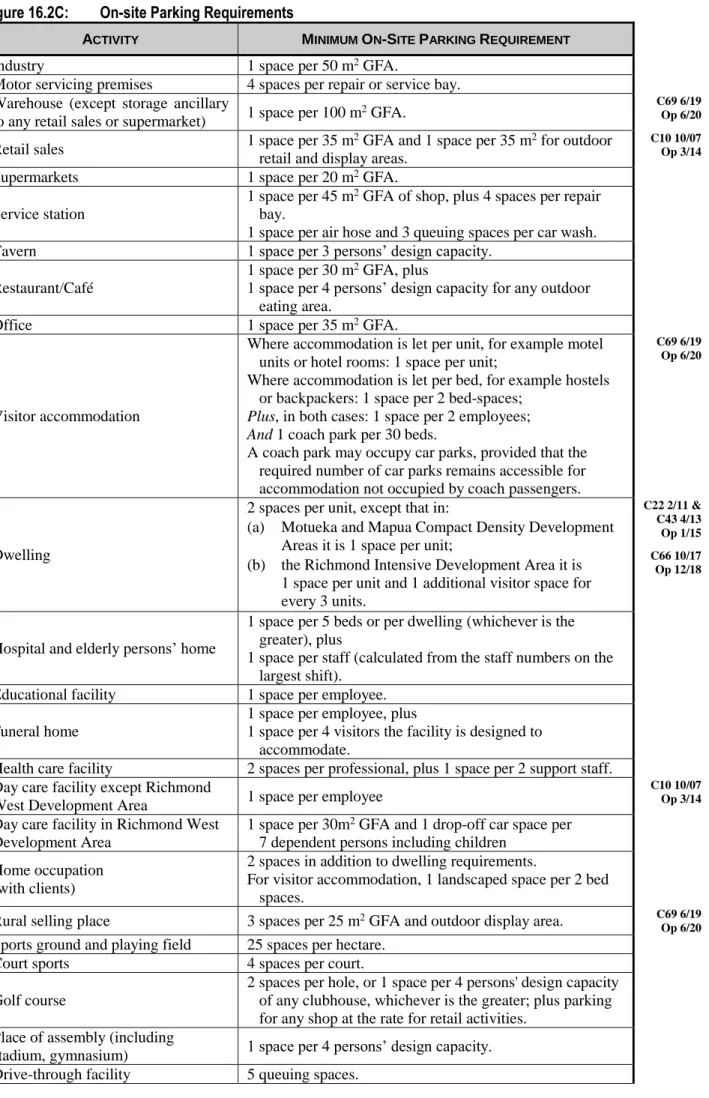
- Permitted Activities (Land Use – Provision for Parking and Loading)
- Controlled Activities (Land Use - Carparking Layout and Landscape Design in Mapua Public
- Controlled Activities (Land Use – Transport Depots)
- Restricted Discretionary Activities (Land Use - General)
Any stormwater drainage feature that forms part of the stormwater drainage network is physically and legally protected from future development that may adversely affect the efficient functioning of the network. Permission can be refused, or conditions imposed, only in respect of the following matters to which the Council has limited its discretion:.
Principal Reasons for Rules
In the larger and busier towns of the District, the Council provides public car parking using funds from financial contributions. Specific dimensional measurements for parking and maneuvering of cars are provided to ensure ease of movement and safety in car parking areas.
Example of Parking Layout
Subdivision
- Scope of Section
- All Zones
- No Permitted Subdivision (All Zones)
- Subdivision in the Slope Instability Risk Area
- Subdivision in the Fault Rupture Risk Area
- Subdivision of Hazardous Activity and Industry List Land
- Subdivision in any Zone Subject to Deferred Zone Rules, or Where Deferred Zoning Has Been
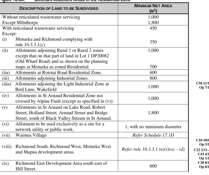
- Residential Zone
- Controlled Subdivision (Residential Zone — Standard Density Development)
- A Controlled Subdivision (Residential Zone – Specific Location: Richmond Intensive Development
- Restricted Discretionary Subdivision (Residential Zone – Listed Cultural Heritage Site)
- A Restricted Discretionary Subdivision (Residential Zone - Standard Density Development)
- B Restricted Discretionary Subdivision (Residential Zone — Specific Location: Richmond
- Restricted Discretionary Subdivision (Residential Zone – Compact Density Specific Locations)
- Discretionary Subdivision (Residential Zone)
- Discretionary Subdivision (Residential Zone – Specific Location)
- Discretionary Subdivision (Residential Closed Zone)
- Non-Complying Subdivision (Residential Zone)]
- Prohibited Subdivision (Residential Closed Zone)
- Prohibited Subdivision (Residential Coastal Zone at Tahi or Iwa Street, Mapua)
- Business and Industrial Zones
- Controlled Subdivision (Business and Industrial Zones)
- Restricted Discretionary Subdivision (Business and Industrial Zones – Richmond West
- Restricted Discretionary Subdivision (Business and Industrial Zones – Cultural Heritage Sites)
- A Restricted Discretionary Subdivision (Industrial Zones – Specified sites at Brightwater)
- Discretionary Subdivision (Central Business, Commercial, Mixed Business, Tourist Services
- Discretionary Subdivision (Tourist Services Zone - Mapua)
- A Discretionary Subdivision (Heavy Industrial Closed Zone – Wakefield)
- Non-Complying Subdivision (Tourist Services Zone - Mapua)
- Prohibited Subdivision (Heavy Industrial Closed Zone – Wakefield)
- Rural 1 Zone
- Controlled Subdivision (Rural 1 and Rural 1 Coastal Zones)
- Restricted Discretionary Subdivision (Rural 1 Zone – Richmond West Development Area)
- Restricted Discretionary Subdivision (Rural 1 Zone – Listed Cultural Heritage Site)
- A Restricted Discretionary Subdivision (Rural 1 Zone)
- Discretionary Subdivision (Rural 1 Zone – Ruby Bay Site)
- A Discretionary Subdivision (Rural 1 Zone)
- Discretionary Subdivision (Rural 1 Closed and Rural 1 Coastal Zones)
- A Non-Complying Subdivision
- Prohibited Subdivision (Rural 1 Closed and Rural 1 Coastal Zones)
- Rural 2 Zone
- Controlled Subdivision (Rural 2 Zone)
- Restricted Discretionary Subdivision (Rural 2 Zone – Richmond West Development Area)
- Restricted Discretionary Subdivision (Rural 2 Zone – Listed Cultural Heritage Site)
- A Restricted Discretionary Subdivision (Rural 2 Zone)
- Rural Residential and Closed Zones
- Controlled Subdivision (Rural Residential Zone)
- Restricted Discretionary Subdivision (Rural Residential Zone – Listed Cultural Heritage Site)
- Restricted Discretionary Subdivision (Rural Residential Zone – Specified Location)
- Restricted Discretionary Subdivision (Rural Residential Zone – Specified Locations)
- A Restricted Discretionary Subdivision (Rural Residential Zone)
- B Discretionary Subdivision (Rural Residential Zone – Cooperative Living)
- Discretionary Subdivision (Rural Residential Zone)
- Discretionary Subdivision (Rural Residential Closed Zone)
- Prohibited Subdivision (Rural Residential Closed Zone)
- All Other Zones
- Discretionary Subdivision (Other Zones)
- Principal Reasons for Rules
In the Richmond West and Motueka West development areas (except in the Light Industrial Zone location at Beach Road as shown on the planning maps). n). Division into Rural District 1 Zone that does not comply with controlled condition (o) in rule 16.3.5.1 is a limited discretionary activity. Division in Rural District 1 Zone that does not comply with conditions (p) or (q) in rule 16.3.5.1 is a limited discretionary activity.
Division in Rural District 2 Zone that does not comply with condition (n) or (o) in rule 16.3.6.1 is a limited discretionary activity. Division in Rural District 3 Zone that does not comply with condition (k) in rule 16.3.7.1 is a limited discretionary activity. Subdivision in the rural residential zone that does not comply with condition (k) of rule 16.3.8.1 is a limited discretionary activity.
A subdivision in a rural residential area that does not comply with condition (a) of rule 16.3.8.1 is a limited discretionary activity.
Assessment Criteria for Subdivision
A copy of this document can be obtained from Transpower New Zealand Ltd. ii) The ability of any planted vegetation to maintain a minimum separation distance of 4 meters from any transmission line conductor, taking into account the mature height of the vegetation. The extent to which access to support structures is maintained for emergency, maintenance and improvement purposes. ii) The extent to which subdivision would limit the ongoing operational needs of the National Grid. The extent to which all stormwater drainage features that form part of the stormwater drainage network are physically and legally protected from future developments that could adversely affect the efficient operation of the network. ii) the extent to which the subdivision project has taken into account changes in land cover; and proposed measures to avoid, correct, or mitigate the effects of these changes on stormwater flows and water quality. iii).
Consideration of existing and reasonably expected future land use changes within the subdivision's catchment area. we). The extent to which the design of the rainwater network takes into account any future changes in the development that may have an impact on or be affected by the development. we you).
Transport Conditions
Services Required on Subdivision in Certain Zones
Esplanade Reserves, Strips and Access Strips
- Scope of Section
- Esplanade Reserves, Strips and Access Strips on Subdivision
- Restricted Discretionary Subdivision (Esplanade Reserves, Strips and Access Strips on
- Restricted Discretionary Subdivision (Esplanade Reserves, Strips and Access Strips on
- Principal Reasons for Rules
The general provision of the law is that an esplanade reserve of 20 meters wide is provided for the construction of an allotment of less than 4 hectares on the above-mentioned wetlands. When an allotment is 4 acres or more, the law states that a plan rule may require that an esplanade reserve or strip of esplanade be reserved, and a resource may waive or change the width of the esplanade reserve or strip. Consent may be withheld or conditions imposed only in respect of the following matters to which the Council has limited its discretion:.
Values that contribute to natural character include the natural functioning of a water body, aquatic and adjacent habitats, and water quality. The Act empowers the Council to take a beach reserve of up to 20 meters in width where land adjacent to the sea or major rivers and lakes in the district is subdivided into plots of less than 4 hectares in area.
Financial Contributions
- Scope of Section
- Financial Contributions
- Circumstances where Financial Contributions will be Imposed
- Purpose of Financial Contributions
- How Financial Contributions have been Set
- Financial Contribution on Subdivision
- Calculation of Financial Contribution on Subdivision (Except for Rural 3, Mapua and Waimea
- Financial Contributions on Subdivision in Rural 3, Mapua and Waimea Inlet Rural Residential
- Reductions, Waivers and Offsets of Financial Contribution on Subdivision (Except for Rural 3
- Reserves and Community Services Component of Financial Contribution on Subdivision
- Non-Complying Activities (Reductions, Waivers and Offsets of Financial Contributions on
- Financial Contributions for New Plantation Forestry
- Financial Contribution Terms for Establishment of New Plantation Forestry
- Financial Contribution on Building Development
- Permitted Activities (Financial Contribution on Building Development)
- Resource Consents (Financial Contribution on Building Development)
- Calculation of Financial Contribution on Development
- Reductions, Waivers and Offsets of Financial Contribution on Building Development
- Financial Contributions on Building Development in the Rural 3 Zone, Mapua and Waimea Inlet
- Non-Complying Activities (Reductions, Waivers and Offsets of Financial Contributions on
- Requirement for Financial Contribution on Resource Consent (Other than for Subdivision or
- Financial Contribution (Limitations)
- Financial Contribution (Limitations)
- Principal Reasons for Rules
Operative Chapter 16 – General Rules July 14 Financial Contributions for Subdivision in Rural Residential Rural Areas 3, Mapua and Waimea Inlet and Services Contribution Area in the Services Contribution Area. Subject to subsection 16.5.1, for each division created by subdivision in Rural Zone 3, the Mapua and Waimea input rural residential zones and the Service Contribution Zone shown on the planning maps, less:. Operative Section 16.5 – Financial contributions July 14 Subdivision financial contribution reductions, waivers and offsets (Except Rural Zone 3, including Rural Closed Zone 3, Rural Residential Rural Zones 3, Mapua and Waimea and Service Contribution Zones) Zone Rural3, Mapua and Waimea Inlet Rural Residential Areas, and Services Contribution Area).
Operational Chapter 16 - General Rules 14 July Reductions, waivers and equalization of financial contributions for the development of buildings. Operational department 16.5 - Financial contributions July 14 Non-compliant activities (reductions, omissions and offsets of financial contributions for construction.
Network Utilities and Public Works
- Scope of Section
- Network Utilities and Public Works
- Permitted Activities (Network Utilities and Public Works)
- Permitted Activities (Aviation and Marine Navigational Aids)
- Restricted Discretionary Activities (Slimline, Self-Supporting Masts and Poles and Attached
- Discretionary Activities (Network Utilities, Public Works, and Aviation and Marine Navigational
- Principal Reasons for Rules
Operational Section 16.6 – Network Services and Public Works June 15 Permitted Activities (Network Services and Public Works). f) The activity is not a waste transfer station, landfill, airport or land-based effluent disposal area or oxidation pond. g). Infrastructure (such as antennas, shrouds, lights or other equipment) attached to a free-standing tower, mast or pole does not exceed a horizontal or vertical cross-sectional area of 4 square meters measured around an imaginary contour of the parts of the external infrastructure, with the exception of the following: The installation, operation and maintenance of an aviation navigation aid or beacon, or marine navigation aid or beacon, is a permitted activity that may be undertaken without resource consent, if the following conditions are met:. a) A navigational aid or beacon is installed for and on behalf of Maritime New Zealand and Airways New Zealand, or the Council, to mark a navigational hazard or for air navigation purposes.
The rules govern the visual effects of overhead lines, towers, dish antennas, masts and other structures according to the sensitivity of the environment within specified zones. There are limited location options for marine navigational aids and beacons to achieve their function of warning of the presence of natural hazards to navigation.
Assessment Criteria – Network Utilities and Public Works
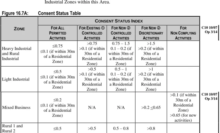
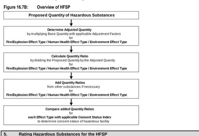
Hazardous Substances
- Scope of Section
- Hazardous Facilities
- Permitted Activities (Hazardous Facilities)
- Controlled Activities (Hazardous Facilities)
- Restricted Discretionary Activities (Hazardous Facilities)
- Non-complying Activities (Hazardous Facilities)
- Radioactive Material
- Prohibited Activities (Radioactive Material Generation, Transport, Storage and Use)
- Principal Reasons for Rules
For underground storage tanks existing before 25 May 1996 for the storage of:. i) more than 5,000 liters of petroleum products in areas outside the aquifer pollution risk area, and. ii) up to 5,000 liters of petroleum products in areas within the aquifer pollution risk area the following applies:. a) the tank and its pipework must be leak tested to determine whether the pipe or tank has a leak or retains its integrity by a person suitably qualified and. Note: Underground storage tanks older than 25 years are considered unsafe. f) The hazardous facility is designed, constructed and operated in a manner that prevents:. i) the unintentional release of the dangerous substance; and. ii) the accumulation of any liquid or solid spills or fugitive vapors or gases in enclosed areas, likely to adversely affect the environment. g). Adherence to relevant codes of practice such as:. i) the Code of Practice for the Management of Agricultural Chemicals NZS8409:1999 (or more recent edition);. ii) the code of practice for the design, installation and operation of underground petroleum storage systems (OSH 1992, or subsequent versions);. iii) the environmental guidelines for water discharge from petroleum industrial sites in New Zealand (MfE 1998 or subsequent versions);.
Adherence to relevant codes of practice such as:. i) the Code of Practice for the Management of Agricultural Chemicals NZS or more recent edition);. ii) the code of practice for the design, installation and operation of underground petroleum storage systems (OSH 1992, or subsequent versions);. iii) the environmental guidelines for water discharge from petroleum industrial sites in New Zealand (MfE 1998 or subsequent versions);. v) for the storage of LPG, the New Zealand and Australian Standard AS or subsequent versions);. No resource permission will be granted for the following prohibited activities:. a) The generation of radioactive material.
Calculation of Cumulative Quantity Ratios
Temporary Activities and Relocated Dwellings
- Scope of Section
- Temporary Activities
- Permitted Activities (Temporary Activities)
- A Permitted Activities (Temporary Activities that are Construction, Maintenance, or Demolition
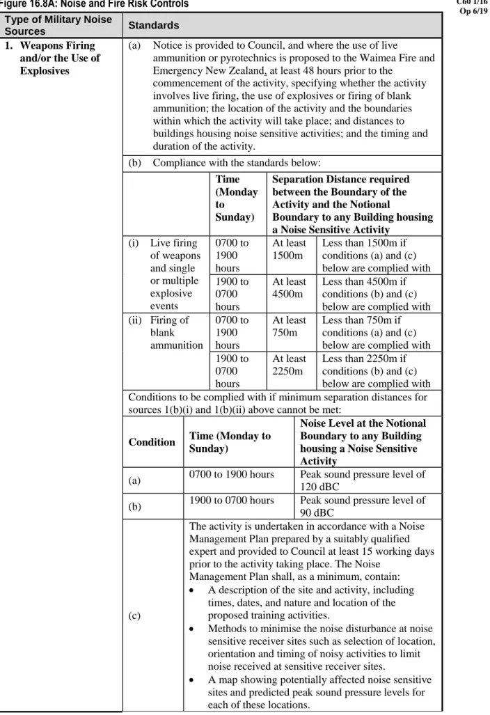
- Permitted Activities (Temporary Military Training Activities)
- Controlled Activities (Temporary Military Training Activities)
- Relocation of Dwellings
- Controlled Activities (Relocation of Dwellings)
Temporary ancillary activity or ancillary activity of building and construction work limited to the duration of the project or for a maximum period of 12 months, whichever is shorter, and the activity meets the following conditions:. a) The activity and the building are easy to move. The activity complies with the transport rules in Article 16.2. c) The environmental manager of the municipality is informed before the start of the project. Any temporary buildings or structures used will be removed at the end of the activity.
A description of the location and activities, including the times, dates, nature and location of the proposed training activities. Relocated apartments can have a negative impact on the visual appeal of the area to which they intend to move.
Flood Hazards
- Scope of Section
- Land Use
- Permitted Activities (Land Use)
- Restricted Discretionary Activities (Land Use)
- Buildings, Berm Lands, Stopbanks
- Prohibited Activities (Buildings, Berm Lands, Stopbanks)
- Principal Reasons for Rules
The rules allow for small storage to occur of the type that might be necessary on a farm or roadside aggregate dump or as part of a river control activity, but must ensure that larger-scale activities will not 'due consideration is given to adverse effects on others before commencing. 0.02 hectare is over 14 meters by 14 meters and is therefore a considerable area). The stop ensures that curbs are kept away from significant obstacles, that initial stop bank failures can be observed and dealt with, and that substantial buildings are kept away from the most dangerous locations. Controlling the type of embankment on the berm helps to ensure that flood flows will not be significantly impeded on the berm.
Including grazing by livestock or excavating or removing part of a stop bank is intended to prevent damage to a major public asset and potentially catastrophic failure of that asset. Limitation of stop bank barriers is necessary to ensure access for inspection purposes is always possible during flooding.
Airport Protection
- Scope of Section
- All Zones
- Permitted Activities (All Zones)
- Restricted Discretionary Activities (All Zones)
- Principal Reasons for Rules
Areas to which Height Control Provisions Apply – Motueka Airport
Areas to which Height Control Provisions Apply – Takaka Airport
Bore Construction or Alteration
- Scope of Section
- Bore Construction or Alteration
- Permitted Activities (Bore Construction or Alteration)
- Controlled Activities (Bore Construction or Alteration)
- Restricted Discretionary Activities (Bore Construction or Alteration)
- Non-Complying Activities (Bore Construction or Alteration)
- Principal Reasons for Rules
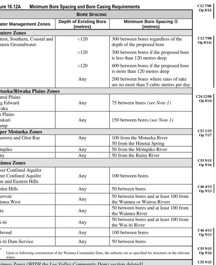
The drill is not drilled. f) The bore is not within 20 meters of any domestic waste water treatment and disposal system. g). The drill is not in the coastal margin of the Hau Plains or Delta zones or in the coastal margin of the Marahau zone. h). The bore is in a water management zone listed in Figure 16.12A and spacing between the proposed bore and any existing bore meets the specified distances, but setbacks do not apply to boreholes used only for monitoring water quality or water quantity.
The drill is not in the coastal fringe of the Hau Plains or Delta zones or in the Marahau zone. The bore is not within any floodway of any river. f) The bore is not within 20 meters of any domestic waste water treatment and disposal system.
Historic Heritage
- Scope of Section
- Minor Repair or Addition to Heritage Building or Structure
- Permitted Activities (Minor Repair to Heritage Building or Structure)
- Restricted Discretionary Activities (Minor Repair or Addition to Heritage Building or Structure)
- Destruction or Removal of Heritage Building or Structure
- Restricted Discretionary Activities (Destruction or Removal of Heritage Building or Structure)
- Non-Complying Activities (Destruction or Removal of Heritage Building or Structure)
- Trimming or Pruning of Protected Tree
- Permitted Activities (Trimming of Protected Tree)
- Controlled Activities (Pruning of Protected Tree)
- Destruction or Removal of Protected Tree
- Restricted Discretionary Activities (Destruction or Removal of Protected Tree)
- Non-Complying Activities (Destruction or Removal of Protected Tree)
- Cultural Heritage Sites
- Permitted Activities (Land Use)
- Controlled Activities (Land Use)
- Restricted Discretionary Activities (Land Use)
- Principal Reasons for Rules
There is no listed cultural heritage area or Schedule 16.13C listed area present on any part of the land. There is a listed cultural heritage site present on any part of the land and the proposed activity will not modify, damage or destroy it. Consent may be refused, or conditions may be imposed, only in respect of the following matters in respect of which the Council has limited its discretion:.
A land permit for the removal, demolition and destruction of the most important heritage items gives the Council the opportunity to assess the value of the heritage and which alternatives, including a heritage decision, may be appropriate. Minor repairs to listed buildings and structures are carried out by operation of law, as this is recognized as important for the continued existence of the building.
Heritage Buildings and Structures
Protected Trees
Cultural Heritage Sites

![Figure 16.3C: Minimum Allotment Areas in Rural Residential Zone [Refer to planning maps for locations]](https://thumb-ap.123doks.com/thumbv2/5docco/6300346.69811/103.893.117.837.284.1145/figure-minimum-allotment-areas-rural-residential-planning-locations.webp)