Trop. For. Manage. J. X (1) : 1-14 (2004)
THE EFFECTS OF CLIMATIC VARIATIONS ON PEAT SWAMP
FOREST CONDITION AND PEAT COMBUSTIBILITY
1)(
Pengaruh Variasi Iklim Terhadap Kondisi Hutan Rawa Gambut Dan
Kemampuan Terbakar Gambut
)
LAILAN SYAUFINA2), AHMAD AINUDDIN NURUDDIN3), JAMALUDDIN BASHARUDDIN, LAI FOOD SEE AND MOHD RASHID MOHD YUSOF4)
ABSTRAK
Studi tentang pengaruh variasi iklim terhadap kondisi hutan rawa gambut dan kemampuan terbakar gambut ini dilaksanakan di Hutan Simpan Sungai karang, Tanjong Karang, Selangor, Malaysia. Tujuan dari studi ini adalah untuk menentukan: 1) Variasi iklim di daerah penelitian , 2) Pengaruh variasi iklim terhadap kondisi hutan rawa gambut; 3) Kemampuan terbakar gambut dan faktor-faktor yang mempengaruhinya; dan 4) Pengaruh kebakaran hutan terhadap kondisi hutan rawa gambut. Studi ini dilakukan di kompartemen 127 selama dua periode, yaitu: Oktober 1999 sampai Januari 2000 dan Mei 2000 sampai Oktober 2000, sementara, studi tentang pengaruh kebakaran dilakukan di kompartemen 132 dari Oktober 1999 sampai dengan Januari 2000.
Studi ini mengklasifikasikan musim kemarau dan musim penghujan sebagai periode dengan curah hujan bulanan berturut-turut kurang dari atau sama dengan 125 mm dan lebih besar dari 125 mm. Daerah penelitian memiliki dua periode kering, yaitu: Januari, Februari, dan Maret sebagai periode pertama dan Mei sampai Agustus sebagai periode kedua. Secara statistik, musim berpengaruh pada kadar air, bulk density, potassium, magnesium, sodium dan tinggi muka air. Dengan menggunakan prediksi curah hujan mingguan, kadar air kritis dari lahan gambut terhadap kebakaran adalah 355 %.
Tingkat Keetch Byram Drought Index (KBDI) yang tinggi terjadi pada tahun 1999/2000 sebanyak dua kali, yaitu pada tanggal 25 dan 26 April 2000. KBDI dapat digunakan untuk memprediksi kadar air dan tinggi muka air di areal penelitian. Berdasarkan luas areal yang terbakar, kedalaman gambut yang terbakar dan warna abu, kebakaran hutan yang terjadi pada tanggal 9 Agustus 1999 merupakan kebakaran dengan intensitas yang rendah. Walaupun demikian, kebakaran hutan tersebut memberikan dampak penurunan Konduktivitas hidrolik (hydraulic conductivity) dan kandungan magnesium serta meningkatkan potassium dan sodium.
Keywords: climatic variations, peat swamp forest, forest fire, peat combustibility
1) Portion of the Ph.D Thesis of Ms. Lailan Syaufina supported by SEARCA
2) Lecturer and Researcher at the Laboratory of Forest Fire. Faculty of Forestry, Bogor Agricultural University,
PO Box 168 Bogor 16001, INDONESIA, Email: [email protected];
3) Professor at the Faculty of Forestry, Universiti Putra Malaysia, 43400 UPM Serdang, Selangor, MALAYSIA 4) Scientist at the Faculty of Chemical and Natural Resources Engineering, Universiti Teknologi Malaysia,
INTRODUCTION
Organic and peat soil in Malaysia covered about 7 % (2.4 million ha) of the land area of which about 0.8 million ha in Peninsular Malaysia, 0.2 million ha in Sabah and 1.4
million ha in Sarawak (Paramanathan et al., 1984). However, peat area in Malaysia, as in
many other countries, has declined due to forest clearance and other developments. It is estimated that the rate of loss of the land was about 23,000 ha per year in the last two decades (Appanah, 1997). According to National Forest Inventory 3 (NFI 3) carried out by the Forestry Department of Peninsular Malaysia, peat swamp forests in Peninsular Malaysia covers an area of 444,680 ha (Mohd. Jinis et al., 2002).
Peat swamp forest plays a very important role in maintaining environmental balance. It prevents flooding during wet season and releases moisture back to the air during dry season. However, peat swamp forest is also a fragile ecosystem. When the forest is cleared, the exposed peat will dry out quickly and catch fire easily. Once this happens, the fire smoulders deep in the earth for a long period. It is nearly impossible to extinguish. Therefore, among forest fire types, peat fire is the most dangerous type.
In South East Asia, forest fire has become more common and has destroyed large forest areas since the last few decades. The forest fire mainly occurred in Indonesia and Malaysia. Fire episode in 1997/1998, has destroyed more than 10 million ha of forest and land in Indonesia (Saharjo, 1999), whereas, about 3,225 ha of forest area burned in Peninsular Malaysia during that period (Samsudin et al., 1999).
Undoubtedly, the 1997/1998-fire episode was worsened by the occurrence of peat fires. The transboundary haze pollution was mainly contributed by some clusters of peat fires in Indonesia particularly in Sumatra and Kalimantan. In 1998, about 99.1 percent of the forest fire in Malaysia occurred in peat forest areas while less than one percent occurred in ordinary forest areas with alluvial and laterite soils including oil palm plantations (Ainuddin and Saidy, 1998).
On the other hand, climatic factors have strong influence on forest fire occurrences and behaviour, particularly the occurrences of drought which are coincided with the ENSO
(El Nino Southern Oscillation) phenomenon (Anonymous, 1998, Lee et al., 2000).
Moreover, several studies (Buckley, 1992, Weise and Biging, 1996, Mori et al., 1999, Saharjo, 1999, Gomez-Tejedor et al., 2000) found that climatic factors influence fire behaviour strongly in terms of ignition, flame development, fire spread and smoke. In addition, fuel characteristics including fuel type, material content, intrinsic character, compactness and fuel moisture content are also influenced by climatic factors (Rice and Martin, 1985, Johansen, 1985, van Wagtendonk and Sydoriak, 1985, Saharjo, 1999).
In contrast to the importance of the peat swamp forest and the dangerous threats on the forest, there were few studies on peat fire conducted in tropical areas. Therefore, an integrated study on peat fire characteristics, behaviour and management is necessary to provide fundamental knowledge on controlling peat fire.
METHODS
Study area
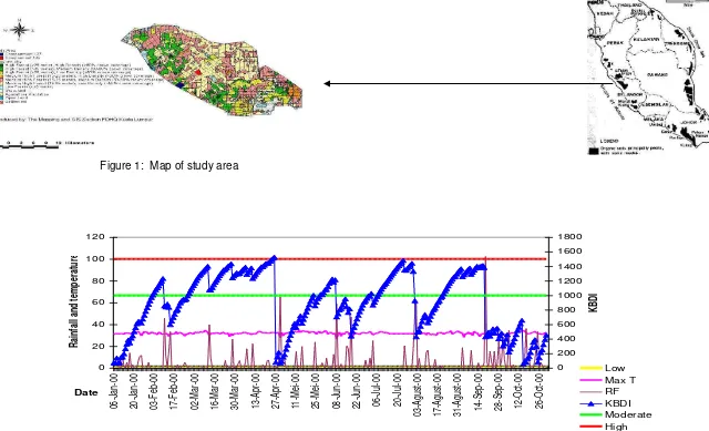
The study area located in the Sungai Karang Forest Reserve, Tanjong Karang, Selangor, between 3o 25‟ N and 3o 35‟ N and longitudes 101o 10‟ E to 101o 25‟ E, is approximately 36,655 ha (Figure 1). Together with Raja Musa Forest Reserve, Sungai Karang Forest Reserve was constituted on 18th January 1990 under Section 7 of the National Forestry Act (Adoption) Enactment 1985 by the Selangor State Government (Razani and Jalil, 1997). Before, they were state lands and have been logged selectively over 50 years ago. They are managed by the Pantai Klang District Forest Office.
Twelve sample plots were established in the burned (compartment 132) and unburned (compartment 127 and 132) areas. Forest fire in August 1999 destroyed about 2 hectares of the peat swamp area in compartment 132.
The study was conducted during two periods, namely: October 1999 to January 2000 (first period) and May 2000 to October 2000 (second period).
Methods
Climatic variations included classification of dry season and wet season in the study area, water balance and drought index. Multivariate cluster analyses, Climatic water balance of Thornthwaite and Mather (1955) and Keetch Byram Drought Index (KBDI) (Keetch and Byram 1988) were applied to determine the climatic variations. A-thirty years climatic data on rainfall and temperature was used in the analyses of season and water balance. Whereas, daily rainfall and maximum temperature for 1999-2000 were used for KBDI.
To observe the dynamic of peat swamp forest condition during the study period, several peat swamp forest condition including, moisture content, pH, bulk density, heat capacity, ash and organic matter contents, inorganic content, hydraulic conductivity and water level were measured.
Sample plots or stations were determined purposively based on the technical accessibility and the representation of condition of the sites. Twenty meters in distance of four stations as core and piezometer sites were established systematically based on the transect line which perpendicular to the small canal on burned (BA) and unburned areas (UA I and UA II).
Samples were taken at five different layers, 0-20 cm, 20-40 cm, 40-60 cm, 60-80 cm and 80-100 cm and were analysed for moisture content, pH, organic content, ash content and inorganic content. Sample for bulk density and hydraulic conductivity were taken at 5 cm and 30 cm depth. Each segment or various depth samples were then sealed in labelled polyvinyl bags for transport to the laboratory. The soil samples were taken fortnightly and analysed by using standard laboratory methods.
cm of the PVC upper part emerged above the ground. The water levels were then measured fortnightly by using small torchlight fastened to the measurement tape.
Univariate data analyses were applied to determine the effects of climatic variations in term of season and the effects of forest fire on peat swamp forest condition.
Peat combustibility was approached by measurement of heat content and combustion rate of the peat. Bomb Calorimeter (IKA-calorimeter system C 5000 control) was used to measure heat content of the peat soil samples. Combustion rate of the peat was measured by using methodology applied by Frandsen (1997). A combustion test box sized 10x10x5 cm for inside dimensions was used to simulate lateral smouldering spread of peat samples. The source of ignition is an electrically powered ignition coil located inside the box, midway between the top and bottom of the sample.
The soil samples were prepared in various moisture content by drying them in the oven in various period of drying. The moisture content and weight variability of the samples were measured. In term of sample volume dimension, sample weight was used to obtain combustion rate as the difficulties in preparing cubical sample. To observe the influence of inorganic content to fire behaviour, the addition of Silica (SiO2) was applied in various levels of 2.5, 5, 7.5, 10, 15, 17.5, 20 and 22.5 %. In total, there were about 150 samples analysed for this test.
The relationship among various peat characteristics (moisture and inorganic matter contents) and variation in combustion rate were obtained using regression analyses.
RESULTS AND DISCUSSIONS
Climatic variations
Climatic variability, in consequence, leads to the concept of climatic “normal” that is an average of climatic elements over at least 30 years (Robinson and Henderson-Sellers 1999). Moreover, it was explained that this long period was sufficient to smooth out the small-scale, year-to-year fluctuations and thus provide a time measurement of the climate. Therefore, climatic variability is the departure from supposedly “normal” conditions that often provide great insight into climatic processes, as well as having the greatest human impacts. Today, to most people, the climate is described by the monthly normals of average temperature and total rainfall.
Table 1. Climatic normals for Tanjong Karang, Selangor
Climatic factors Number of
observation day Mini mum
Maxi mum
Mean Standard
Deviation
Rainfall (mm) 372 7 505 148.9 88.3
Maximum temperature (oC) 372 28.3 33.9 31.1 0.8
Minimum temperature (oC) 372 20.8 25.2 23.1 0.6
Relative humidity (%) 372 58 96 77.4 6.6
To analyse the effects of climatic variations on peat swamp forest condition, the study defined season based on cluster analysis of the rainfall. Cluster analysis is defined as a group of multivariate techniques whose primary purposes is to group objects based on the characteristics they possess. It classifies objects so that each object is very similar to others in the cluster with respect to some predetermined selection criteria. The resulting clusters of objects should then exhibit high internal (within-cluster) homogeneity and high external (between-cluster) heterogeneity (Hair et al., 1998).
Results from cluster analysis shows that the rainfall distribution in the study area can be grouped into two classes, namely: dry and wet season. The cluster centres are 124.9 mm and 323.5 mm for dry and wet season respectively. Based on the cluster centres, the study defined dry season as a period when monthly rainfall is similar or less than 125 mm and wet season as a period when monthly rainfall is greater than 125 mm.
The departure of rainfall „normal‟ sometimes occur within a year in an area. The lack of rainfall received by an area is associated with the term „drought‟ in general. According to Pyne et al. (1996), drought period is an interval of time, generally of the order of months or years in duration, during which the actual moisture supply at a given place rather consistently falls short of the climatically expected or climatically appropriate moisture supply.
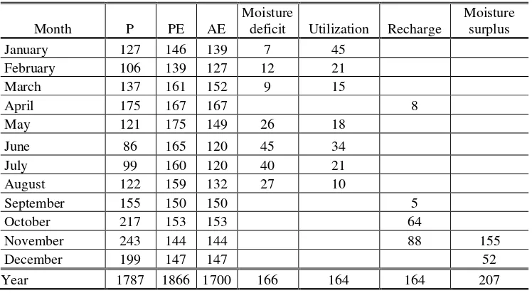
Table 2. The long-term (1968-1998) climatic water balance (millimeters) for Tanjong Karang, Selangor
Month P PE AE
Moisture
deficit Utilization Recharge
Moisture surplus
January 127 146 139 7 45
February 106 139 127 12 21
March 137 161 152 9 15
April 175 167 167 8
May 121 175 149 26 18
June 86 165 120 45 34
July 99 160 120 40 21
August 122 159 132 27 10
September 155 150 150 5
October 217 153 153 64
November 243 144 144 88 155
December 199 147 147 52
Year 1787 1866 1700 166 164 164 207
Information on drought occurrences will be very useful in assessing forest fire risk in an area as a precaution in forest fire management. To simplify the utilization of drought information several type of drought index have been developed.
Drought Index is an important tool for fire potential assessment. Keetch-Byram Drought Index (KBDI) is one of the kind, which has been applied in many countries including Indonesia. It is a continuous reference scale for estimating the dryness of the soil and duff layers. It relates to the flammability of organic material in the ground (Pyne et al. 1996). The index is based on the calculation of several climatic factors, namely: annual and daily rainfall and maximum temperature that are available in every meteorological station.
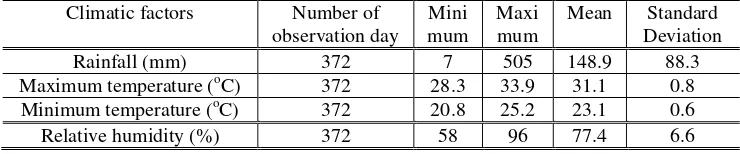
Daily climatic data of Tanjong Karang in the period of January 1999 to October 2000 were analysed to build such KBDI for the area. KBDI of Tanjong Karang fluctuated with time (Figure 2). It ranged from 68 on 9 January 2000 to 1524 on 26 April 2000, from low to high stage. Based on the stage classification, the KBDI during the study period can be defined as: low (54.85 %), moderate (44.48 %) and high (0.67 %). The high stages were observed twice, namely on 25 and 26 April 2000 of that were the transition period towards dry season. The moderate stages were found from 2 to 9 February 2000, from 27 February to 24 April 2000, on 23 July 2000, and from 21 August to 18 September 2000.
KBDI = 1169.13 – 8.143 RF (1)
Though KBDI was developed based on mineral soil moisture condition, it still can be a best tool when applied to peat soil condition.
The effects of climatic variations on peat swamp forest condition
Climatic variations play an important role in peatland formation, which is characterised by the accumulation of organic matter. The formation of peat as a result of the greater rate in producing and depositing of organic matter than in decomposing, is influenced by climatic variables such as rainfall and temperature. On the other hand, in their pristine state, peat swamp forests stabilize local climatic condition. Among the climatic factors, rainfall seems to play a major role in determining of peat characteristics in tropical condition. Therefore, this study merely focused on the effects of season (wet and dry) which reflects rainfall distribution and fluctuation on several peat characteristics and hydrological condition of peat swamp forest.
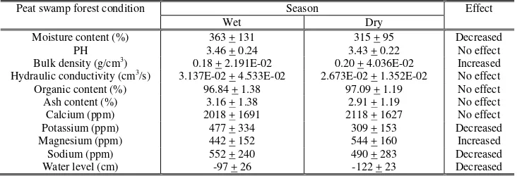
Climatic variations affected peat swamp forest conditions at various degrees. Statistically, season as a reflection of rainfall occurrence and distribution influenced several peat characteristics that of moisture content, bulk density, potassium, magnesium, sodium contents and water level. Moreover, rainfall was linearly related to moisture content. In summary, the descriptive of peat characteristics based on season are shown in Table 3.
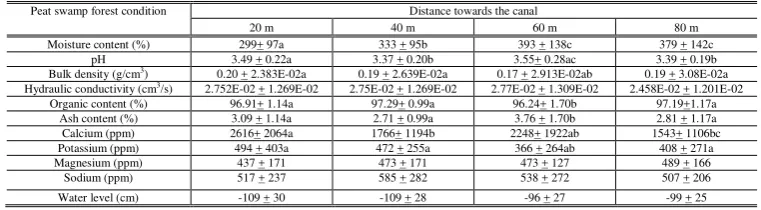
Peat characteristics also varied with peat layers (Table 4) and distance towards the canal (Table 5). Statistically, peat layers influenced moisture content, pH, organic content, ash content, calcium and sodium contents significantly. On the other hand, plot or distance towards the canal affected moisture content, bulk density, pH, organic content, ash content, calcium and potassium contents. However, peat swamp forest condition are not influenced by single factor alone, the interaction among the independent factors of season, peat layers and distance towards the canal have significant effects to the peat swamp forest condition.
Table 3. Summary of mean peat swamp forest condition in different season in unburned area I (UA I) in Sungai Karang Forest Reserve, Tanjong Karang, Selangor
Peat swamp forest condition Season Effect
Wet Dry
Moisture content (%) 363 + 131 315 + 95 Decreased PH 3.46 + 0.24 3.43 + 0.22 No effect Bulk density (g/cm3) 0.18 + 2.191E-02 0.20 + 4.036E-02 Increased
Hydraulic conductivity (cm3/s) 3.137E-02 + 4.533E-02 2.673E-02 + 1.352E-02 No effect
Table 4. Summary of mean peat characteristics at various peat layers in unburned area I (UA I) in Sungai Karang Forest Reserve, Tanjong Karang, Selangor
Peat characteristics
/s) 3.256E-02 + 2.709 E-02 5.231E-02 + 1.152E-02 not measured not measured not measured Organic content (%) 95.38+ 1.47a 96.95 + 1.0b 97.41 + 1.07b 97.52+ 0.83bc 97.27+0.97b
* Mean are significantly different when standard deviations are followed by different letters (p < 0.05)
Table 5. Summary of mean peat swamp forest condition in various distances towards the canal in unburned area I (UA I) in Sungai Karang Forest Reserve, Tanjong
Karang, Selangor
Peat swamp forest condition Distance towards the canal
20 m 40 m 60 m 80 m
Moisture content (%) 299+ 97a 333 + 95b 393 + 138c 379 + 142c pH 3.49 + 0.22a 3.37 + 0.20b 3.55+ 0.28ac 3.39 + 0.19b Bulk density (g/cm3
) 0.20 + 2.383E-02a 0.19 + 2.639E-02a 0.17 + 2.913E-02ab 0.19 + 3.08E-02a Hydraulic conductivity (cm3/s) 2.752E-02 + 1.269E-02 2.75E-02 + 1.269E-02 2.77E-02 + 1.309E-02 2.458E-02 + 1.201E-02
Organic content (%) 96.91+ 1.14a 97.29+ 0.99a 96.24+ 1.70b 97.19+1.17a Ash content (%) 3.09 + 1.14a 2.71 + 0.99a 3.76 + 1.70b 2.81 + 1.17a Calcium (ppm) 2616+ 2064a 1766+ 1194b 2248+ 1922ab 1543+ 1106bc Potassium (ppm) 494 + 403a 472 + 255a 366 + 264ab 408 + 271a independent variables or predictors, the statistical analysis suggested that only rainfall has a significant effect on moisture content. Therefore, peat moisture content (MC) can be predicted by weekly rainfall (RF) as presented by equation 2. The model has a moderate performance with R2 = 0.537.
MC = 316 + 1.003 RF (2)
Drought occurrence also influenced water level. Drought occurrence may cause lowering of water level due to the evaporation of the soil surface and transpiration of the vegetation cover, beside water up taking by the vegetation. Moreover, Gilman (1994) explained that during dry periods, the day-to-day decline in
Statistically, there was a relationship between water level (Y) and KBDI (X) with a moderate performance of the model (R2 = 0.53). The following model suggested that KBDI can be used to predict water level of the peat swamp area significantly:
Y = -52.05 – 0.057 X (3)
Furthermore, drought index is a useful tool in predicting forest fuel condition. This study observed that a best-fit for peat moisture content (Y) – KBDI (X) model is a non linear regression equation with R2 = 0.55, as follows:
Y = 1555.99 X –0.2289 (4)
Peat combustibility
Knowledge of variations in heat content of wildland fuel is important in predicting fire behaviour or assessing the combustibility of different fuel complexes. It explains how susceptible is the fuel to fire. Heat content also influences the fire‟s rate of spread. The higher the heat content of the fuel the more susceptible to fire the fuel will be. Furthermore, the forest fuel may produce high combustion heat to the environment. Hence, it may increase the flammability of the forest fuel.
Heat content is influenced by several factors in different manner. Among them are moisture content, bulk density or compactness of the fuel and chemical component of the fuels. The study revealed that heat content highly fluctuated with the moisture contents, it appeared to decrease with moisture content. The peat in the study area had high value of heat content, ranging from 7.133 KJ/g to 22.688 KJ/g (Table 5). This means that the peat soil is a good fuel and highly flammable. The minimum heat content was observed at the moisture content of 303 % and the maximum one was found at the moisture content of 11 %. Statistical analysis observed a direct relationship with relatively high correlation (79 %) between heat content and moisture content.
Regression analyses suggested that the model with heat content as a dependent variable and moisture content as a predictor observed a moderate performance (R2 = 0.628). As such, the moisture content (X) may be used to estimate the heat content (Y) such as follows:
Y = 19.790 – 4.281E-02 X (5)
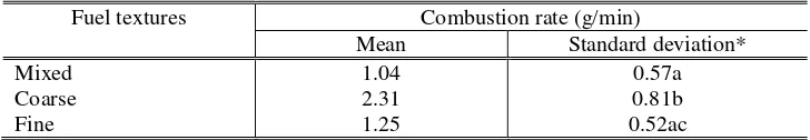
Therefore, fuel texture may influence the combustion rate. The mean combustion rates in different textures are shown in Table 6.
Statistical analysis observed that fuel texture affected combustion rate significantly. The combustion rate of coarse fuel texture was significantly higher than those of mixed and fine fuel textures. However, there was no difference of combustion rates of mixed and fine fuel textures. The fine texture fuel which was found mostly in the high decomposed peat seemed to be more compacted and hold moisture content stronger than the coarse texture. Besides, the oxygen in the fine texture was less freely moving among the soil pores when compared with the coarse texture fuel. As such, the fire had more difficulty in consuming the fine texture fuel. In contrast, the coarse texture fuel which is commonly found in the surface peat layer (low decomposed) seemed to be looser that allow the oxygen supply more freely move and so the fire will be easily consume the fuel.
Table 6. Mean peat combustion rate at various textures in Sungai Karang Forest Reserve, Tanjong Karang, Selangor
Fuel textures Combustion rate (g/min)
Mean Standard deviation*
Mixed 1.04 0.57a
Coarse 2.31 0.81b
Fine 1.25 0.52ac
* Mean are significantly different when standard deviations are followed by different letters (p < 0.05)
Furthermore, the study observed no obvious trend of combustion rate when it was related to silica addition. Statistical analysis observed that the effect of SiO2 addition on combustion rate can be modelled with Vapour Pressure Model (Figure 4.34). The model has a good performance (R2 = 0.74). Therefore, the following model can be used to predict the effect of SiO2 addition (X) on combustion rate (Y):
Y = exp (2.32 – 4.21/X – 0.63 Ln(X)) (6)
The effects of forest fire on peat swamp forest condition
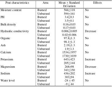
Forest fires affect soil properties vary depending on many factors such as the type of soil, the moisture content of soil, the intensity and duration of fire, the timing and intensity of post-fire precipitation (Chandler et al., 1983), and the other properties of the fuel (Pyne et al., 1996). The consequences are physical, chemical and biological. The results seem to be different and vary from place to place. The effects of fire on peat soil is more serious than that of on other soil type, though, only a few studies have been performed on peat soil. The study on the effects of forest fire in Sungai Karang Forest Reserve is summarized in Table 7.
outwards from the ignition point, resulting in a bowl-shaped burned depression being created. Burning generally continues until it either reaches mineral soil or a location where the moisture content of the soil prohibits further combustion. Fires in organic soil do not move fast, but they can persist for weeks, months or longer (De Bano et al., 1998). Table 7. Possible effects of forest fire on peat swamp forest condition in Sungai Karang
Forest Reserve, Tanjong Karang, Selangor
Peat characteristics Area Mean + Standard
Deviation
Effects
Moisture content Burned 566+118 No
Unburned 594+161
PH Burned 3.4+0.3 No
Unburned 3.5+0.1
Bulk density Burned 0.16+0.03 No
Unburned 0.17+0.03
Hydraulic conductivity Burned 0.006+0.005 Decrease
Unburned 0.02+0.006
Organic Burned 97.8+1.3 No
Unburned 98.1+1.3
Ash Burned 2.19+1.3 No
Unburned 1.9+1.3
Calcium Burned 1534+1957 No
Unburned 1730+1039
Potassium Burned 643+423 Increase
Unburned 205+144
Magnesium Burned 268+98 Decrease
Unburned 343+150
Sodium Burned 436+202 Increase
Unburned 303+94
Water level Burned -24 + 45 No
Unburned -9 + 44
There are several factors influencing the severity of forest fire effects on soil properties. The intensity and duration of fire, the timing and intensity of post-fire precipitation seem to play significant role in the study area. The fire caused the decreasing of hydraulic conductivity and magnesium content and the increasing of potassium and sodium contents. High post-fire precipitation may reduce the fire effects. Based on the burned area, burning depth (< 25 cm) and ash colour, forest fire occurred in the study area is classified as a light fire. Therefore, no severe effects of fire on peat swamp forest conditions were observed.
effect to the area which may lead to the increasing of surface run off. Though there was no severe effects of forest fire experienced by the study area, peat fire control including fire prevention need to be considered in managing the forest.
RECOMMENDATIONS
1. Peat moisture content can be predicted by weekly rainfall and KBDI respectively. The critical peat moisture content to fire is 355 %.
2. The prevention activities should be performed, particularly before January when the water deficit starting to occur in the area and during dry season (May-September) when forest fuels experience the most susceptible condition.
3. The combustion test box used in this study need to be improved in term of size and effectiveness. The size should be smaller which can fit the limited samples from each different peat layers. Besides, this kind of study requires more combustion box in one batch of combustion test to perform test simultaneously and reduce the influence of initial temperature.
4. Larger samples in various peat layers and texture should be used for combustion test
for having better understanding on peat fire behaviour.
5. Similar studies need to be developed in other forest area to support and strengthen integrated forest fire management system in Malaysia.
6. The study findings can be employed as a basic information for an early warning system in forest fire management in Sungai Karang Forest Reserve.
ACKNOWLEDGEMENTS
The authors wish to thank SEAMEO SEARCA for its kind financial support during the study, International Tropical Timber Organization for financial support in the final stage of the study and IRPA Project for partly financial support in the field and laboratory facilities.
LITERATURES CITED
Ainuddin, A. N. and M. Saidy M. Yusof. 1998. Forest fire management in Malaysia: Current practices. In Tropical forest fire, prevention, control, rehabilitation and trans-boundary issues. Proceeding International Cross Sectoral Forum on Forest Fire Management in South East Asia. Jakarta, December 7- 8. BAPPENAS-JICA-ITTO. Indonesia. pp. 108-314.
Anonymous. 1998. Coal and peat fires in South Sumatra. Forest fire prevention and control project Indonesia Province of South Sumatra. World Wide Web version.
http://www.mdp.co.id
Appanah, S. 1997. Peat swamp forests of Peninsular Malaysia: The endanger ecosystem. In P. Havmoller, C. Tuek Yuan and Razani U. eds. Proceedings of the Workshop on Sustainable Management of Peat Swamp Forest. Forestry Department Headquarters and State Forestry department Selangor. Kuala Selangor, 29 Sept-1Oct. Malaysian-DANCED Project on Sustainable Management of Peat Swamp Forests. Malaysia. pp. 6-14.
Chandler, C., P. Cheney, P. Thomas, L. Trabaud, D. Williams. 1983. Fire in Forestry Vol. I. John Wiley and Sons. Canada. 450 pp.
Frandsen, W. H. 1997. Ignition probability of organic soils. Can. J. For. Res. 27: 1471-1477.
Gilman, K. 1994. Hydrology and Wetland Conservation. John Wiley and Sons. New York, USA. 101pp.
Gomez-Tejedor, J. A., M. J. Estrela and M. M. Millan. 2000. A mesoscale model application to fire weather winds. International Journal of Wildland Fire 9 (4): 255-265.
Hair, J. F. Jr., R. E. Anderson, R. L. Tatham and W. C. Black. 1998. Multivariate Data Analysis. (5th ed.). Prentice Hall. New Jersey, USA. 730 pp.
Johansen, R. W. 1985. Effect of drought on live fuel moisture content. In L. R. Donoghue and R. E. Martin eds., Weather-The Drive Train Connecting the Solar Engine to Forest Ecosystems. Society of American Foresters. Bethesda. USA. pp. 47-51.
Keetch, J. J. and G. M. Byram. 1988. A drought index for forest Fire control (Revision). USDA Forest Service. Southeastern Forest Experiment Station, Asheville, North Carolina. USA. 32 pp.
Lee, B., M. Brady, A. Sasitiwarih and H. Sandhu. 2000. Wildland fires as a source of air pollution: Recent experience in Southeast Asia. In Proceedings of Forests and Society: the Role of Research. Poster Abstracts Vol. III. XXI IUFRO World Congress. Kuala Lumpur 7-12 August 2000. Malaysian XXI IUFRO World Congress organizing committee. Malaysia. pp. 311.
Mohd. Jinis, A., Mahmad Rashid, I and Abdul Rahman, A. R. 2002. The incidence of forest fire in Peninsular Malaysia: History, root causes, prevention and control.
Paper presented in Workshop on Prevention and Control of Fire in Peatlands. 19th–
Paramanathan, S., S. Zauyah, C. P. Lim, Y. K. Chan, and D. Boaklan. 1984. Proposal for a unified classification of organic soil in Malaysia. Proceedings Workshop on Classification and Management of Peat in Malaysia. MSSS. Kuala Lumpur, Malaysia. pp. 127-157.
Pyne, S. J., P. L. Andrews, R. D. Laven. 1996. Introduction to Wildland Fire. 2nd ed. John Wiley and Sons. New York. 769 pp.
Razani, U. and Hj. MD. S. Jalil 1997. Status of peat swamp forests in Selangor. In P. Havmoller, C. Tuek Yuan and Razani, U. eds., Proceedings of the Workshop on Sustainable Management of Peat Swamp Forest. Forestry Department Headquarters and State Forestry Department Selangor. Kuala Selangor, 29 September-1 October 1997. Malaysian-DANCED Project on Sustainable Management of Peat Swamp Forests. Malaysia. pp. 15-21.
Robinson, P. J. and A. Henderson-Sellers. 1999. Contemporary Climatology. (2nd ed.). Longman. Singapore. 317 pp.
Saharjo, B. H. 1999. Study on forest fire prevention for fast-growing tree species Acacia
mangium plantation in South Sumatra, Indonesia. Doctoral Thesis of Faculty of
Agriculture. Kyoto University. Japan. 107pp.
Samsudin, M., M. P. Dahlan, S. Wan Mohd. Shukri, R. Ibrahim, R. S. Barizan, A. Hassan, I. Harun and I. Parlan. 1999. Forest fire in Peninsular Malaysia: A new and recurring threat. In H. Suhartoyo and T. Toma eds., Proceedings 3rd International Symposium on Asia Tropical Forest Management. Samarinda, Indonesia. September 20-23, 1999. Pusrehut special publication No. 8. Tropical Forest Research Center, Mulawarman University and Japan International Agency. Indonesia. pp. 62-71.
19
Figure 2:
Daily rainfall, maximum temperature and KBDI in various stages in Sungai Karang Forest Reserve, Tanjong Karang, Selangor
Trop. For. Manage. J. X (1) : 1-14 (2004)
THE EFFECTS OF CLIMATIC VARIATIONS ON PEAT SWAMP
FOREST CONDITION AND PEAT COMBUSTIBILITY
1)(
Pengaruh Variasi Iklim Terhadap Kondisi Hutan Rawa Gambut Dan
Kemampuan Terbakar Gambut
)
LAILAN SYAUFINA2), AHMAD AINUDDIN NURUDDIN3), JAMALUDDIN BASHARUDDIN, LAI FOOD SEE AND MOHD RASHID MOHD YUSOF4)
ABSTRAK
Studi tentang pengaruh variasi iklim terhadap kondisi hutan rawa gambut dan kemampuan terbakar gambut ini dilaksanakan di Hutan Simpan Sungai karang, Tanjong Karang, Selangor, Malaysia. Tujuan dari studi ini adalah untuk menentukan: 1) Variasi iklim di daerah penelitian , 2) Pengaruh variasi iklim terhadap kondisi hutan rawa gambut; 3) Kemampuan terbakar gambut dan faktor-faktor yang mempengaruhinya; dan 4) Pengaruh kebakaran hutan terhadap kondisi hutan rawa gambut. Studi ini dilakukan di kompartemen 127 selama dua periode, yaitu: Oktober 1999 sampai Januari 2000 dan Mei 2000 sampai Oktober 2000, sementara, studi tentang pengaruh kebakaran dilakukan di kompartemen 132 dari Oktober 1999 sampai dengan Januari 2000.
Studi ini mengklasifikasikan musim kemarau dan musim penghujan sebagai periode dengan curah hujan bulanan berturut-turut kurang dari atau sama dengan 125 mm dan lebih besar dari 125 mm. Daerah penelitian memiliki dua periode kering, yaitu: Januari, Februari, dan Maret sebagai periode pertama dan Mei sampai Agustus sebagai periode kedua. Secara statistik, musim berpengaruh pada kadar air, bulk density, potassium, magnesium, sodium dan tinggi muka air. Dengan menggunakan prediksi curah hujan mingguan, kadar air kritis dari lahan gambut terhadap kebakaran adalah 355 %.
Tingkat Keetch Byram Drought Index (KBDI) yang tinggi terjadi pada tahun 1999/2000 sebanyak dua kali, yaitu pada tanggal 25 dan 26 April 2000. KBDI dapat digunakan untuk memprediksi kadar air dan tinggi muka air di areal penelitian. Berdasarkan luas areal yang terbakar, kedalaman gambut yang terbakar dan warna abu, kebakaran hutan yang terjadi pada tanggal 9 Agustus 1999 merupakan kebakaran dengan intensitas yang rendah. Walaupun demikian, kebakaran hutan tersebut memberikan dampak penurunan Konduktivitas hidrolik (hydraulic conductivity) dan kandungan magnesium serta meningkatkan potassium dan sodium.
Keywords: climatic variations, peat swamp forest, forest fire, peat combustibility
1) Portion of the Ph.D Thesis of Ms. Lailan Syaufina supported by SEARCA
2) Lecturer and Researcher at the Laboratory of Forest Fire. Faculty of Forestry, Bogor Agricultural University,
PO Box 168 Bogor 16001, INDONESIA, Email: [email protected];
3) Professor at the Faculty of Forestry, Universiti Putra Malaysia, 43400 UPM Serdang, Selangor, MALAYSIA 4) Scientist at the Faculty of Chemical and Natural Resources Engineering, Universiti Teknologi Malaysia,
INTRODUCTION
Organic and peat soil in Malaysia covered about 7 % (2.4 million ha) of the land area of which about 0.8 million ha in Peninsular Malaysia, 0.2 million ha in Sabah and 1.4
million ha in Sarawak (Paramanathan et al., 1984). However, peat area in Malaysia, as in
many other countries, has declined due to forest clearance and other developments. It is estimated that the rate of loss of the land was about 23,000 ha per year in the last two decades (Appanah, 1997). According to National Forest Inventory 3 (NFI 3) carried out by the Forestry Department of Peninsular Malaysia, peat swamp forests in Peninsular Malaysia covers an area of 444,680 ha (Mohd. Jinis et al., 2002).
Peat swamp forest plays a very important role in maintaining environmental balance. It prevents flooding during wet season and releases moisture back to the air during dry season. However, peat swamp forest is also a fragile ecosystem. When the forest is cleared, the exposed peat will dry out quickly and catch fire easily. Once this happens, the fire smoulders deep in the earth for a long period. It is nearly impossible to extinguish. Therefore, among forest fire types, peat fire is the most dangerous type.
In South East Asia, forest fire has become more common and has destroyed large forest areas since the last few decades. The forest fire mainly occurred in Indonesia and Malaysia. Fire episode in 1997/1998, has destroyed more than 10 million ha of forest and land in Indonesia (Saharjo, 1999), whereas, about 3,225 ha of forest area burned in Peninsular Malaysia during that period (Samsudin et al., 1999).
Undoubtedly, the 1997/1998-fire episode was worsened by the occurrence of peat fires. The transboundary haze pollution was mainly contributed by some clusters of peat fires in Indonesia particularly in Sumatra and Kalimantan. In 1998, about 99.1 percent of the forest fire in Malaysia occurred in peat forest areas while less than one percent occurred in ordinary forest areas with alluvial and laterite soils including oil palm plantations (Ainuddin and Saidy, 1998).
On the other hand, climatic factors have strong influence on forest fire occurrences and behaviour, particularly the occurrences of drought which are coincided with the ENSO
(El Nino Southern Oscillation) phenomenon (Anonymous, 1998, Lee et al., 2000).
Moreover, several studies (Buckley, 1992, Weise and Biging, 1996, Mori et al., 1999, Saharjo, 1999, Gomez-Tejedor et al., 2000) found that climatic factors influence fire behaviour strongly in terms of ignition, flame development, fire spread and smoke. In addition, fuel characteristics including fuel type, material content, intrinsic character, compactness and fuel moisture content are also influenced by climatic factors (Rice and Martin, 1985, Johansen, 1985, van Wagtendonk and Sydoriak, 1985, Saharjo, 1999).
In contrast to the importance of the peat swamp forest and the dangerous threats on the forest, there were few studies on peat fire conducted in tropical areas. Therefore, an integrated study on peat fire characteristics, behaviour and management is necessary to provide fundamental knowledge on controlling peat fire.
METHODS
Study area
The study area located in the Sungai Karang Forest Reserve, Tanjong Karang, Selangor, between 3o 25‟ N and 3o 35‟ N and longitudes 101o 10‟ E to 101o 25‟ E, is approximately 36,655 ha (Figure 1). Together with Raja Musa Forest Reserve, Sungai Karang Forest Reserve was constituted on 18th January 1990 under Section 7 of the National Forestry Act (Adoption) Enactment 1985 by the Selangor State Government (Razani and Jalil, 1997). Before, they were state lands and have been logged selectively over 50 years ago. They are managed by the Pantai Klang District Forest Office.
Twelve sample plots were established in the burned (compartment 132) and unburned (compartment 127 and 132) areas. Forest fire in August 1999 destroyed about 2 hectares of the peat swamp area in compartment 132.
The study was conducted during two periods, namely: October 1999 to January 2000 (first period) and May 2000 to October 2000 (second period).
Methods
Climatic variations included classification of dry season and wet season in the study area, water balance and drought index. Multivariate cluster analyses, Climatic water balance of Thornthwaite and Mather (1955) and Keetch Byram Drought Index (KBDI) (Keetch and Byram 1988) were applied to determine the climatic variations. A-thirty years climatic data on rainfall and temperature was used in the analyses of season and water balance. Whereas, daily rainfall and maximum temperature for 1999-2000 were used for KBDI.
To observe the dynamic of peat swamp forest condition during the study period, several peat swamp forest condition including, moisture content, pH, bulk density, heat capacity, ash and organic matter contents, inorganic content, hydraulic conductivity and water level were measured.
Sample plots or stations were determined purposively based on the technical accessibility and the representation of condition of the sites. Twenty meters in distance of four stations as core and piezometer sites were established systematically based on the transect line which perpendicular to the small canal on burned (BA) and unburned areas (UA I and UA II).
Samples were taken at five different layers, 0-20 cm, 20-40 cm, 40-60 cm, 60-80 cm and 80-100 cm and were analysed for moisture content, pH, organic content, ash content and inorganic content. Sample for bulk density and hydraulic conductivity were taken at 5 cm and 30 cm depth. Each segment or various depth samples were then sealed in labelled polyvinyl bags for transport to the laboratory. The soil samples were taken fortnightly and analysed by using standard laboratory methods.
cm of the PVC upper part emerged above the ground. The water levels were then measured fortnightly by using small torchlight fastened to the measurement tape.
Univariate data analyses were applied to determine the effects of climatic variations in term of season and the effects of forest fire on peat swamp forest condition.
Peat combustibility was approached by measurement of heat content and combustion rate of the peat. Bomb Calorimeter (IKA-calorimeter system C 5000 control) was used to measure heat content of the peat soil samples. Combustion rate of the peat was measured by using methodology applied by Frandsen (1997). A combustion test box sized 10x10x5 cm for inside dimensions was used to simulate lateral smouldering spread of peat samples. The source of ignition is an electrically powered ignition coil located inside the box, midway between the top and bottom of the sample.
The soil samples were prepared in various moisture content by drying them in the oven in various period of drying. The moisture content and weight variability of the samples were measured. In term of sample volume dimension, sample weight was used to obtain combustion rate as the difficulties in preparing cubical sample. To observe the influence of inorganic content to fire behaviour, the addition of Silica (SiO2) was applied in various levels of 2.5, 5, 7.5, 10, 15, 17.5, 20 and 22.5 %. In total, there were about 150 samples analysed for this test.
The relationship among various peat characteristics (moisture and inorganic matter contents) and variation in combustion rate were obtained using regression analyses.
RESULTS AND DISCUSSIONS
Climatic variations
Climatic variability, in consequence, leads to the concept of climatic “normal” that is an average of climatic elements over at least 30 years (Robinson and Henderson-Sellers 1999). Moreover, it was explained that this long period was sufficient to smooth out the small-scale, year-to-year fluctuations and thus provide a time measurement of the climate. Therefore, climatic variability is the departure from supposedly “normal” conditions that often provide great insight into climatic processes, as well as having the greatest human impacts. Today, to most people, the climate is described by the monthly normals of average temperature and total rainfall.
Table 1. Climatic normals for Tanjong Karang, Selangor
Climatic factors Number of
observation day Mini mum
Maxi mum
Mean Standard
Deviation
Rainfall (mm) 372 7 505 148.9 88.3
Maximum temperature (oC) 372 28.3 33.9 31.1 0.8
Minimum temperature (oC) 372 20.8 25.2 23.1 0.6
Relative humidity (%) 372 58 96 77.4 6.6
To analyse the effects of climatic variations on peat swamp forest condition, the study defined season based on cluster analysis of the rainfall. Cluster analysis is defined as a group of multivariate techniques whose primary purposes is to group objects based on the characteristics they possess. It classifies objects so that each object is very similar to others in the cluster with respect to some predetermined selection criteria. The resulting clusters of objects should then exhibit high internal (within-cluster) homogeneity and high external (between-cluster) heterogeneity (Hair et al., 1998).
Results from cluster analysis shows that the rainfall distribution in the study area can be grouped into two classes, namely: dry and wet season. The cluster centres are 124.9 mm and 323.5 mm for dry and wet season respectively. Based on the cluster centres, the study defined dry season as a period when monthly rainfall is similar or less than 125 mm and wet season as a period when monthly rainfall is greater than 125 mm.
The departure of rainfall „normal‟ sometimes occur within a year in an area. The lack of rainfall received by an area is associated with the term „drought‟ in general. According to Pyne et al. (1996), drought period is an interval of time, generally of the order of months or years in duration, during which the actual moisture supply at a given place rather consistently falls short of the climatically expected or climatically appropriate moisture supply.
Table 2. The long-term (1968-1998) climatic water balance (millimeters) for Tanjong Karang, Selangor
Month P PE AE
Moisture
deficit Utilization Recharge
Moisture surplus
January 127 146 139 7 45
February 106 139 127 12 21
March 137 161 152 9 15
April 175 167 167 8
May 121 175 149 26 18
June 86 165 120 45 34
July 99 160 120 40 21
August 122 159 132 27 10
September 155 150 150 5
October 217 153 153 64
November 243 144 144 88 155
December 199 147 147 52
Year 1787 1866 1700 166 164 164 207
Information on drought occurrences will be very useful in assessing forest fire risk in an area as a precaution in forest fire management. To simplify the utilization of drought information several type of drought index have been developed.
Drought Index is an important tool for fire potential assessment. Keetch-Byram Drought Index (KBDI) is one of the kind, which has been applied in many countries including Indonesia. It is a continuous reference scale for estimating the dryness of the soil and duff layers. It relates to the flammability of organic material in the ground (Pyne et al. 1996). The index is based on the calculation of several climatic factors, namely: annual and daily rainfall and maximum temperature that are available in every meteorological station.
Daily climatic data of Tanjong Karang in the period of January 1999 to October 2000 were analysed to build such KBDI for the area. KBDI of Tanjong Karang fluctuated with time (Figure 2). It ranged from 68 on 9 January 2000 to 1524 on 26 April 2000, from low to high stage. Based on the stage classification, the KBDI during the study period can be defined as: low (54.85 %), moderate (44.48 %) and high (0.67 %). The high stages were observed twice, namely on 25 and 26 April 2000 of that were the transition period towards dry season. The moderate stages were found from 2 to 9 February 2000, from 27 February to 24 April 2000, on 23 July 2000, and from 21 August to 18 September 2000.
KBDI = 1169.13 – 8.143 RF (1)
Though KBDI was developed based on mineral soil moisture condition, it still can be a best tool when applied to peat soil condition.
The effects of climatic variations on peat swamp forest condition
Climatic variations play an important role in peatland formation, which is characterised by the accumulation of organic matter. The formation of peat as a result of the greater rate in producing and depositing of organic matter than in decomposing, is influenced by climatic variables such as rainfall and temperature. On the other hand, in their pristine state, peat swamp forests stabilize local climatic condition. Among the climatic factors, rainfall seems to play a major role in determining of peat characteristics in tropical condition. Therefore, this study merely focused on the effects of season (wet and dry) which reflects rainfall distribution and fluctuation on several peat characteristics and hydrological condition of peat swamp forest.
Climatic variations affected peat swamp forest conditions at various degrees. Statistically, season as a reflection of rainfall occurrence and distribution influenced several peat characteristics that of moisture content, bulk density, potassium, magnesium, sodium contents and water level. Moreover, rainfall was linearly related to moisture content. In summary, the descriptive of peat characteristics based on season are shown in Table 3.
Peat characteristics also varied with peat layers (Table 4) and distance towards the canal (Table 5). Statistically, peat layers influenced moisture content, pH, organic content, ash content, calcium and sodium contents significantly. On the other hand, plot or distance towards the canal affected moisture content, bulk density, pH, organic content, ash content, calcium and potassium contents. However, peat swamp forest condition are not influenced by single factor alone, the interaction among the independent factors of season, peat layers and distance towards the canal have significant effects to the peat swamp forest condition.
Table 3. Summary of mean peat swamp forest condition in different season in unburned area I (UA I) in Sungai Karang Forest Reserve, Tanjong Karang, Selangor
Peat swamp forest condition Season Effect
Wet Dry
Moisture content (%) 363 + 131 315 + 95 Decreased PH 3.46 + 0.24 3.43 + 0.22 No effect Bulk density (g/cm3) 0.18 + 2.191E-02 0.20 + 4.036E-02 Increased
Hydraulic conductivity (cm3/s) 3.137E-02 + 4.533E-02 2.673E-02 + 1.352E-02 No effect
Table 4. Summary of mean peat characteristics at various peat layers in unburned area I (UA I) in Sungai Karang Forest Reserve, Tanjong Karang, Selangor
Peat characteristics
/s) 3.256E-02 + 2.709 E-02 5.231E-02 + 1.152E-02 not measured not measured not measured Organic content (%) 95.38+ 1.47a 96.95 + 1.0b 97.41 + 1.07b 97.52+ 0.83bc 97.27+0.97b
* Mean are significantly different when standard deviations are followed by different letters (p < 0.05)
Table 5. Summary of mean peat swamp forest condition in various distances towards the canal in unburned area I (UA I) in Sungai Karang Forest Reserve, Tanjong
Karang, Selangor
Peat swamp forest condition Distance towards the canal
20 m 40 m 60 m 80 m
Moisture content (%) 299+ 97a 333 + 95b 393 + 138c 379 + 142c pH 3.49 + 0.22a 3.37 + 0.20b 3.55+ 0.28ac 3.39 + 0.19b Bulk density (g/cm3
) 0.20 + 2.383E-02a 0.19 + 2.639E-02a 0.17 + 2.913E-02ab 0.19 + 3.08E-02a Hydraulic conductivity (cm3/s) 2.752E-02 + 1.269E-02 2.75E-02 + 1.269E-02 2.77E-02 + 1.309E-02 2.458E-02 + 1.201E-02
Organic content (%) 96.91+ 1.14a 97.29+ 0.99a 96.24+ 1.70b 97.19+1.17a Ash content (%) 3.09 + 1.14a 2.71 + 0.99a 3.76 + 1.70b 2.81 + 1.17a Calcium (ppm) 2616+ 2064a 1766+ 1194b 2248+ 1922ab 1543+ 1106bc Potassium (ppm) 494 + 403a 472 + 255a 366 + 264ab 408 + 271a independent variables or predictors, the statistical analysis suggested that only rainfall has a significant effect on moisture content. Therefore, peat moisture content (MC) can be predicted by weekly rainfall (RF) as presented by equation 2. The model has a moderate performance with R2 = 0.537.
MC = 316 + 1.003 RF (2)
Drought occurrence also influenced water level. Drought occurrence may cause lowering of water level due to the evaporation of the soil surface and transpiration of the vegetation cover, beside water up taking by the vegetation. Moreover, Gilman (1994) explained that during dry periods, the day-to-day decline in
Statistically, there was a relationship between water level (Y) and KBDI (X) with a moderate performance of the model (R2 = 0.53). The following model suggested that KBDI can be used to predict water level of the peat swamp area significantly:
Y = -52.05 – 0.057 X (3)
Furthermore, drought index is a useful tool in predicting forest fuel condition. This study observed that a best-fit for peat moisture content (Y) – KBDI (X) model is a non linear regression equation with R2 = 0.55, as follows:
Y = 1555.99 X –0.2289 (4)
Peat combustibility
Knowledge of variations in heat content of wildland fuel is important in predicting fire behaviour or assessing the combustibility of different fuel complexes. It explains how susceptible is the fuel to fire. Heat content also influences the fire‟s rate of spread. The higher the heat content of the fuel the more susceptible to fire the fuel will be. Furthermore, the forest fuel may produce high combustion heat to the environment. Hence, it may increase the flammability of the forest fuel.
Heat content is influenced by several factors in different manner. Among them are moisture content, bulk density or compactness of the fuel and chemical component of the fuels. The study revealed that heat content highly fluctuated with the moisture contents, it appeared to decrease with moisture content. The peat in the study area had high value of heat content, ranging from 7.133 KJ/g to 22.688 KJ/g (Table 5). This means that the peat soil is a good fuel and highly flammable. The minimum heat content was observed at the moisture content of 303 % and the maximum one was found at the moisture content of 11 %. Statistical analysis observed a direct relationship with relatively high correlation (79 %) between heat content and moisture content.
Regression analyses suggested that the model with heat content as a dependent variable and moisture content as a predictor observed a moderate performance (R2 = 0.628). As such, the moisture content (X) may be used to estimate the heat content (Y) such as follows:
Y = 19.790 – 4.281E-02 X (5)
Therefore, fuel texture may influence the combustion rate. The mean combustion rates in different textures are shown in Table 6.
Statistical analysis observed that fuel texture affected combustion rate significantly. The combustion rate of coarse fuel texture was significantly higher than those of mixed and fine fuel textures. However, there was no difference of combustion rates of mixed and fine fuel textures. The fine texture fuel which was found mostly in the high decomposed peat seemed to be more compacted and hold moisture content stronger than the coarse texture. Besides, the oxygen in the fine texture was less freely moving among the soil pores when compared with the coarse texture fuel. As such, the fire had more difficulty in consuming the fine texture fuel. In contrast, the coarse texture fuel which is commonly found in the surface peat layer (low decomposed) seemed to be looser that allow the oxygen supply more freely move and so the fire will be easily consume the fuel.
Table 6. Mean peat combustion rate at various textures in Sungai Karang Forest Reserve, Tanjong Karang, Selangor
Fuel textures Combustion rate (g/min)
Mean Standard deviation*
Mixed 1.04 0.57a
Coarse 2.31 0.81b
Fine 1.25 0.52ac
* Mean are significantly different when standard deviations are followed by different letters (p < 0.05)
Furthermore, the study observed no obvious trend of combustion rate when it was related to silica addition. Statistical analysis observed that the effect of SiO2 addition on combustion rate can be modelled with Vapour Pressure Model (Figure 4.34). The model has a good performance (R2 = 0.74). Therefore, the following model can be used to predict the effect of SiO2 addition (X) on combustion rate (Y):
Y = exp (2.32 – 4.21/X – 0.63 Ln(X)) (6)
The effects of forest fire on peat swamp forest condition
Forest fires affect soil properties vary depending on many factors such as the type of soil, the moisture content of soil, the intensity and duration of fire, the timing and intensity of post-fire precipitation (Chandler et al., 1983), and the other properties of the fuel (Pyne et al., 1996). The consequences are physical, chemical and biological. The results seem to be different and vary from place to place. The effects of fire on peat soil is more serious than that of on other soil type, though, only a few studies have been performed on peat soil. The study on the effects of forest fire in Sungai Karang Forest Reserve is summarized in Table 7.