DOI: 10.12928/TELKOMNIKA.v14i3A.4422 145
Digital Management Mechanism of Sudden Geological
Disaster Emergency Plan
Lu Huang1, Xiangang Luo2*, Zhong Xie3, Luyang Xiang4, Jingmin Tu5 1,2,3,5
Faculty of Information Engineering, China University of Geosciences, Wuhan, Hubei, 430073, P. R. China
4
Engineering Department, The 709th Research Institute of China Shipbuilding Industry Corporation, Wuhan, Hubei, 430070, P. R. China
*Corresponding author, e-mail: [email protected]
Abstract
Digital emergency plan is an important part of the emergency platform. This paper proceeds as follow. Firstly, it presents the key technologies of digital emergency plan, emphasizing feature extraction, multi-source information fusion and GIS technology. And then the processes of the geological disaster emergency plan are discussed based on the “The national sudden geological disaster emergency plan” for guideline, including regional geological disaster warning information response process and single geological disaster emergency response information flow. Moreover, the digital prototype system is designed, including the framework of geological disaster emergency plan of the overall structure, database and function modules. Finally, based on MapGIS platform, B/S mode, using Flex, Flash Builder technology, it developed the prototype system for experiment.
Keywords: Geological disaster; Emergency plan; Digital; GIS
Copyright © 2016 Universitas Ahmad Dahlan. All rights reserved.
1. Introduction
China is one of the worst-hit countries by geological disasters in the world. Especially the sudden geological hazard would be hugely damaging, such as collapse, landslides, mudslide ground sink and so on. During the past decade, the sudden geological hazard has caused significant loss of people's lives and property safety each year. It restricts the sustainable development of our society.
When disaster is coming, emergency plan is an important basis for making decision of geological disaster emergency. On January 13, 2006, “The national sudden geological disaster emergency plan” was released in our country. It reflected that the geological disaster emergency response work became standardized and normalized in China [1].
Inform of text, the emergency plan has made outstanding contributions to the geological disaster emergency work. However, with the increasing of sudden geological disasters, some shortcomings of the text emergency plan have occurred in practice. (1) Static text plan is not intuitive, timeliness, poor operability in the process of implementation. (2) Making emergency decision often needs many aspects of emergency information by support, the text plan cannot provide sharing information. (3) Emergency disposal strategies need to be developed by the actual situation of the disaster, the text plan cannot achieve it. Therefore, it is necessary to construct digital plan for using modern technology. It can play an important role in disaster prevention and reduction.
Foreign research of digital plan started early. There are typical projects, such as digital emergency plan system in America Savannah coastal area, American Ohio oil emergency response system [2], emergency response plan and management system in Dartmouth, Britain, crisis prevention information system in Germany [3, 4], the Uthmaniyah gas processing plant emergency response plan system in sandi Arabia and so on.
China woke up late to emergency management theory and technology. The standard of emergency management system is still relatively frail. Through the massive literature retrieval, we found that the articles about the analysis of digital emergency plan, process modeling are limited.
At present, in our country, we have established some digital plan system in several areas, such as the environmental pollution [9, 10], earthquake [11, 12], city track traffic [13], the campus emergency [14], flood control [15]. But the geological disaster emergency plan digital system is an unusual. The sudden geological disasters digital emergency plan is still in an original stage.
Digital emergency plan is the implementation of the platform. It is an important part of the emergency platform. Based on the “The national sudden geological disaster emergency plan” for the program, using feature extraction, multi-source information fusion and GIS technology, the paper analysis process of the geological disaster emergency plan. And then design digital prototype system, including the framework of geological disaster emergency plan of the overall structure, database and function modules. Based on MapGIS platform, B/S mode, using Flex, Flash Builder technology, it developed the prototype system for experiment. It achieves high efficiency and visualization of geological disaster emergency plan implementation process.
The structure of the paper is as follows. To begin with we will provide a brief background on the digital plan. Details on digital management mechanism of sudden geological disaster emergency plan are discussed in later sections. Section 2 discusses sudden geological disaster emergency plan process which includes general process of geological disaster emergency, information flow of regional geological disaster emergency response and information flow of single geological disaster emergency response. Section 3, prototype system is developed for verifying the digital management mechanism. Section 4 is the conclusion of the paper.
2. Research Method 2.1. Key Technology
(1) Feature extraction technology
Feature extraction is from text features to select the most representative features, in order to reduce the dimension of feature space, which can achieve the purpose of reducing the computational complexity and improving the classification accuracy. In the process of the digital geological disaster emergency plan, we need to use feature extraction technology.
For example, extract important information about the geological disaster from “The national sudden geological disaster emergency plan”, such as plans to start conditions, disaster emergency response level, emergency organization, and so on. Extract the truth from the report information, such as geological disaster type, time, place, personnel casualties and economic losses, the rescue, and so on.
(2) Multisource information fusion technology
According to the actual demand of digital plan, for the main elements of information involved in “The national sudden geological disaster emergency plan”, the collation, comparison, processing and coordination and comprehensive treatment of geological hazard information collected is needed to obtain the correlation and integration of information fusion.
In the paper, based on data center technology and spatial data engine (SDE) technology, by means of combination of the multi-source information for emergency plans in space or time redundancy or complementarity, it realizes the unity of the data storage and management of geological disaster spatial and nonspatial data in the database.
(3) GIS Technology
Using the spatial analysis and spatial database management functions of GIS, combined with the geological disasters emergency procedures, it can provide technical support for the research of digitalized preplan [17, 18].
Table 1. GIS applied in geological disaster emergency plan in digitization
The function of GIS Applied in geological disaster emergency plan in Digitization
Spatial data management
Geospatial information, information on geological disasters, the meteorological early warning information, resource distribution and
information management
Two or three-dimensional visualization Disaster map display, 3D scene simulation
Buffer analysis Analysis of disaster affected area
Path analysis Transfer the evacuation path analysis
Overlay analysis Analysis of the threat of disaster area population
…… ……
2.2. Digital Flow Analysis of Sudden Geological Disaster Emergency Plan (1) Overall process of geological disaster emergency
According to “The national sudden geological disaster emergency plan”, by the idea of emergency management of backbone chain drives the key link of emergency response technology, to design the main process of emergency management. It includes disaster warning, disaster response preparation, identification, emergency disposal, response to the end (Figure 1).
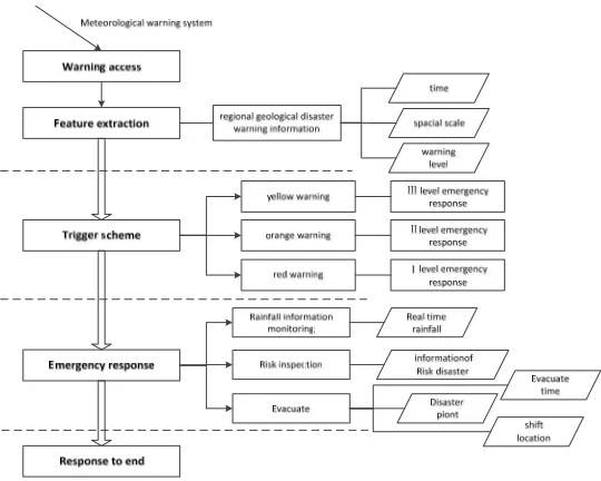
(2) Information flow of regional geological disaster emergency response
Early warning of regional geological hazard warning forecasting, refers to a geological disaster warning information release mechanism in a certain period which geo-logical disasters may occur collapse, landslides, mudslides and others.
Using feature extraction technology, extract feature of “The national sudden geological disaster emergency plan”. According to the regional geological disaster early warning response plan work process, it can be divided into the early warning, emergency response plan, triggering, and warning termination stage. The core content of the digital early warning of regional geological disaster response plan is shown in Figure 2.
(3) Information flow of single geological disaster emergency response
Single geological disaster emergency plan is in response to the occurrence of geological disasters, in view of the specific characteristics of geological disaster or hidden points and the environment. According to the local economic and social level or ability, disaster prevention and mitigation work program can ensure personal safety, property safety and environment and advance the development of the good.
Using feature extraction technology, extract feature of “The national sudden geological disaster emergency plan”. The work processes of single emergency plan included preliminary geological disasters, verification, start plan, emergency response and response of end stage.
Figure 1. Division of geological disaster emergency stage
Figure 2. Information flow of regional geological disaster emergency response
3. Results and Analysis 3.1. Development Framework
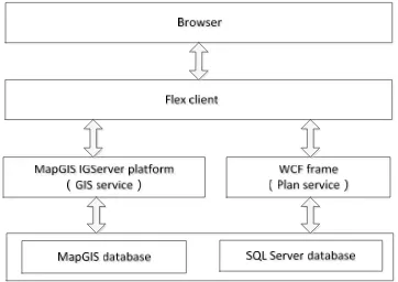
The prototype system is developed based on MapGIS platform, using the browser / server mode (B/S mode). The customer terminal is developed by Flex technology, using Flash Builder 4.5 as the client development environment. Web server uses WCF framework to develop and mature, it will be released to the IIS application server, and for the client calls. The data layer uses Microsoft SQL Server2005 as the database file management system, GIS data server layer uses spatial data for storage and management capabilities provided by MapGIS platform, to solve the complex problems of spatial data access, modify the data type, and so on (Figure 4).
3.2. Overall Framework Design
The construction of sudden geological disasters digital emergency plan system is based on B/S model, MapGIS IGServer platform. The four layer structure including the data layer, GIS application support layer, application layer and user layer (Figure 5).
Figure 4. Development framework Figure 5. Overall system architecture
3.3. Database Design
In the geological disaster emergency plan digital sys-tem, it needs the massive spatial data and relational data-base for data support, the data types can be divided into the following six types of database: basic geographic database, basic geological database, geological hazard database, meteorological warning database, rainfall database and emergency resource database. The spatial data is stored in the MapGIS SDE, using SQL Server database to store the relational data (Figure 6).
3.4. Function Design
According to different contingency plan, the functions of sudden geological disaster emergency plan digital sys-tem includes two parts, regional geological disasters and geological disasters haplotype module (Figure 7).
Regional geological
Disaster grade evaluation
Disaster grade evaluation
Disaster grade evaluation
Disaster grade evaluation
Experts to verify
Experts to verify
formation of expert group
formation of expert group
Figure 7. System function structure
4. Conclusion
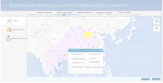
In conclusion, the paper analyzes the process of the geological disaster emergency plan. And then design digital prototype system. Based on MapGIS platform, B/S mode, using Flex, Flash Builder technology, the prototype system is developed for experiment. The prototype system inter-face is shown in Figure 8.
It transfers the emergency plan in the implementation of the information from the original into a modern way. It changes the emergency plan in the implementation of technology by the experience of experts into intelligent auxiliary means. Future work includes: (1) To achieve Intelligent emergency plan using intelligent technology. (2) To establish a typical emergency management case data-base is another aspect.
Figure 8. Interface of prototype system
Conflict of Interest
The authors confirm that this article content has no conflicts of interest.
Acknowledgements
References
[1] CZ Liu. Basic problem on emergency disposition of abrupt heavy geological disaster. Journal of
natural disasters. 2006; 15: 24-30.
[2] C Zhang, YQ Pei, H Qiu. Current status and development trend of digital emergency plan at home
and abroad. Journal of Safety Science and Technology. 2010; 6(5): 154-158.
[3] YH Liu, CZ Liu, MS Wen. Study of early warning models for reginal geo-hazards in China. Journal of
Engineering Geology. 2015; 23(4): 738-746.
[4] M Alvioli, RL Baum. Parallelization of the TRIGRS model for rainfall-induced landslides using the message passing interface. Environmental Modelling & Software. 2016; 81: 122-135.
[5] Krishna SV, Pal N, Sadhu PK. Post Disaster Illumination for Underground Mines. TELKOMNIKA
Indonesian Journal of Electrical Engineering. 2015; 13(3): 425-430.
[6] M Hoogendoorn, C Jonker, V Popova. Formal modelling and comparing of disaster plans. In:
Proceedings of the 2nd International ISCRAM Conference. Brussels, Belgium. 2005; 97-107.
[7] Ontrup J, Wersing H, Ritter H. A computational feature binding model of human texture perception.
Cognitive Processing. 2004; 5(1): 31-44.
[8] M Scaioni, M Alba, R Rota, S Caragliano. A GIS-Based SW Prototype for Emergency Preparedness Management Applied to a Real Case Study. In: Gervasi O, Taniar D, Murgante B, et al, eds.
Computational Science and Its Applications - ICCSA 2009. Seoul, Korea: Springer Berlin Heidelberg.
2009; 29: 79-93.
[9] MS Wen, LJ Wang, TF Li. Meteorological early warning of geological hazards based on maximum potentiality parameter of village. Journal of Beijing Jiao Tong University. 2012; 36(4): 110-114. [10] X Zhang, TJ Wang, ZQ Jiang. System and application of digital dynamic emergency air pollution
emergency plan. Journal of safety and environment. 2012; 12(1): 254-260.
[11] Y Zhang, DF Huang, WF Chen. The key technology of Earthquake emergency plan digitization
research. Journal of Safety Science and Technology. 2014; 10(5): 95-102.
[12] Arora VK. Quantum Nanoengineering Nonequilibrium High-Electric-Field Transport for Signal
Propagation. Proceeding of the Electrical Engineering Computer Science and Informatics. 2015; 2(1):
1-9.
[13] HM Guo, WF Chen, Y Zhang. Execution Auxiliary System for Earthquake Contingency Plans. China
Earthquake Engineering Journal. 2014; 36(1): 178-185.
[14] L Zhang. Study of Sharing Technology of Ontology-based e-Learning Resources. Journal of
Southwest China Normal University (Natural Science Edition). 2009; 34(6): 204-207.
[15] X Li, W Wang, XY Bi. Visual platform of intelligent campus unexpected public incident. Application
Research of Computers. 2009; 26: 3369-3371, 3387.
[16] HX Li, XL Gao, JM Zhang. Flood control plan visualization management system of Yellow River in Henan. Yellow river. 2006; 28: 16-19.
[17] Oluwole FJ, Olajide OY. Radio frequency propagation mechanisms and empirical models for hilly
areas. International Journal of Electrical and Computer Engineering (IJECE). 2013; 3(3): 372-376.
[18] Siti Urbayatun, Erlina Listyanti Widuri, Ani Muttaqiyatun, Dewi Eskawati. The Model of Intervention
Among Survivor's of Disaster. International Journal of Public Health Science (IJPHS). 2014; 3(3):