1st International Conference on Infrastructure Development, UMS Surakarta, 1 – 3 Nov 2013 ISBN 978-979-636-154-4
219
AN INTEGRATED APPROACH FOR THE BANGER POLDER
DEVELOPMENT, SEMARANG
Jln. Solo – Kartosuro Km. 7, Pabelan,Surakarta, 57162
The Banger area is named after the main channel in the area: the Kali Banger. The area are located in low land areas near the coastal, and are expossed to be flood/inundationcaused by sea water level, poor drainage and escalated with land subsidence. The polder concept has been identified as a suitable solution for the problems. The Polder system requires an integrated approach in some technical aspects and economic prespective, such as defining the safety level, the water level to be controlled. So the size of retention basin and pump capacity can be determined, since all these aspects are related to each other. And these will influence to the O&M costs and reduction of damage. Based on the analysis (Net Present Value) of (additional) investment costs, O&M costs and reduction of damage, the optimal safety level has been determined on T10.
Key Words: polder, flood and inundation, safety level, O&M cost, reduction of damage
INTRODUCTION
Many of Asia’s cities are located in low land areas near the coastal and there are expossed to be flood/inundation caused by sea water level, and poor drainage. These conditions are escalated with land subsidence and climate change. The climate change is related with the change of rainfall and flood incidence, not to speak of a sea level rise.
The physical character of Semarang City consists of hilly area in south side and flat area in north side. Because of the above condition the area of North City is always threatened by flood and inundation. The land subsidence and increasing sea water level that cause increasing the water level and inundation time to the North City.
The Banger area are located at North of Semarang City, comprises 550 ha and 84,000 inhabitants. The Banger area is named after the main channel in the area: the Kali Banger. The water level in the Kali Banger is now determined by the sea with the sea flowing into the area during high tide and water flowing to the sea during low tide. In the current situation the land level is around Mean Sea Level (MSL), but with a land subsidence rate of 9 cm/year the Banger area is progressively sinking below the sea.
Due to the land subsidence the flooding events in Semarang are increasing in frequency and severity. There are two principal mechanisms that are relevant with regard to flooding:
- flood caused by high water level outside the polder (Rob); - inundation caused by heavy rainfall (Banjir).
Both types of flood are mainly caused by land subsidence. The former one because the coastal area is progressively subsiding below sea water level. The latter one because the discharge of the rainfall is blocked by high water levels in the Kali Banger. Increase in paved areas and negligence of maintenance and clogging of the existing drainage infrastructure increases the inundation. Climate change will further worsens the situation due to sea level rise (althouhg not to much high) and increase in rainfall in the wet season.
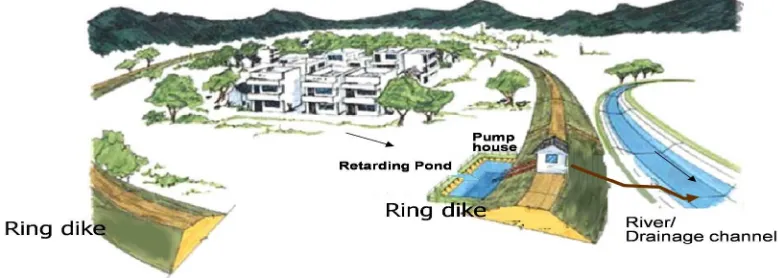
The polder concept has been identified as a suitable solution to resolve the current problems with flood and inundation in Semarang, because polder separate the water regime inside the polder area from the water regime outside by closed ring dike to protect the area from water which come from out side. The water table inside the polder is controlled through structures (tidal gate and/or pumping station)’.
– !- -" "- #$-$
with all stakeholders like PSDA, Bappeda, BBWS and also land owners involved, like Bina Marga
and Kereta Api. Thirdly it requires an integrated approach in some technical aspects, such as
defining the safety level, the water level to be controlled, retention and pump capacity, since all
these aspects are related to each other. These technical aspects are explained in the next sections.
Figure 1Poder system
LITERATUR REVIEW
Some technical aprroach for flood control, there are land increasing ground level and developing pump system (polder system). A polder is an area, surrounded by a closed ring of flood protection elements (sea defence, dikes, and water management system) to separate the water regime inside the polder area from the water regime outside, and to control the water table inside the area. (Bart Schultz, 2010).
For every project to be conceived, there must be some defonitr aims behind its existance. The fulfillment of these objectives with minimum cost is the most importance thing. The polder design involves many choice among physically feasibility alternatives. So Each choice among alternatives should be made on economic basic and each alternatives should be express in term of money units before the final choice is made (Bhagirath L. G., 1979)
Financial record resulting from past at describing what has happened in the past, but for decision-making process of cost aim at projecting what expected to happen in the future as a result of alternative of action. The present worth methode for economy studies is based on the concept of equivalent worth of all cash flow retavie to some base or beginning point in time called the present That is, all cash inflows and outflows are discounted back at an interest rate that is generally minimum attractive rate of return.(DeGarmo, E. P., 1979).
Direct benefit from flood control consist of reduction of damages to land property and increase in net income resulting from more intensive use of and land or property made possible by reduction of flood
1st International Conference on Infrastructure Development, UMS Surakarta, 1 – 3 Nov 2013 ISBN 978-979-636-154-4
221 hazards. Indirect benefit is come from reduction in loss of production which may be interrupted by freuquent and reduction cost of recurring emergency relief to flood victim, etc.
METHODOLOGY
Literature review is used for identification of concept and criteria for evaluating, describing and explaining the method will be used for polder design.
In the paper three sources of data are used,
1. Document analysis is used as a history of decisions of the past and to support our data
2. Technical data and economic forecast will be used for determined Net Present Value
3. Direct observation to observe the outcome of the process
Secondary data such as, project document, minute of meeting, power point slides are used to describe, and analyze of the projects process and outcomes.The data gathered from observation, and written documentation results in a large pile information. To structure and analyze these data, template analysis provides guidance. Template analysis involves the development of categories to which units.
Validity and Reliability data refers to the approximate truth of the stated propositions and always involves human judgment (Shades, Cook and Campbell, 2002).
The cost of damage are caused by flood /inundation, and the cost for flood protection will be bring to the present value, the elements to determining of safety level in Figure Appendix.
The present worth method for economy studies is used for determined of safety level of dike, water level must be control, and also pump and retention pump capacity. The criterion for the method is long as the net present worth is 0, the project is economically justified; otherwise, it is not justified. Based on Figure Appendix, all the cost of element safety level will be bring to present value (Figure 3).
Figure 3 Present worth method
INTEGRATED APPROACH IN TECHNICAL ASPECTS
Safety Level
The safety level of dikes and the water management system is expressed as the return period T. A dike with a safety level T10 means that mean every years the probability of dike will overtop or break is 10 %.
In accordance with the two flood causing mechanisms, there are two safety levels. One for flood caused by the sea (rob) and one safety level caused by rainfall (banjir). The Rob can reach high inundation levels (a meter or more) and subsequently higher damage. The Banjir is limited to the volume of the rainfall within the catchment area, resulting in lower inundation levels generally (centimeters to decimeters). To determine the optimal safety levels, an economic assessment has been carried out.
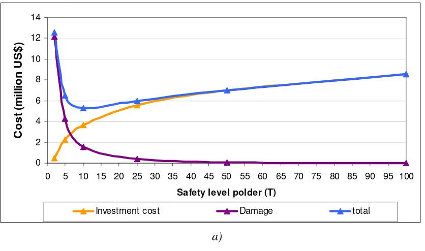
For the assessment on the internal water management system (protection Banjir) comprising the pumping station and the retention basin and main channel, an simple approach has been followed. In this approach the safety level is expressed as the size of the retention basin. A larger retention basin is more expensive, but also provide a higher the safety level, resulting in less (economic) damage.A higher safety level not only results in a lower frequency of inundation, but also in a lower inundation depth and damage
1st International Conference on Infrastructure Development, UMS Surakarta, 1 – 3 Nov 2013 ISBN 978-979-636-154-4
Figure 4Retention area and safety level internal water management system
Based on the analysis (Net Present Value) of (additional) investment costs, O&M costs and reduction of damage, the optimal safety level has been determined on T10.
a)
b) Figure5Additional investment cost and damage Internal water management system
For the dikes a higher safety level of T10,000 is the optimum. This is because with a relatively small additional height a much higher safety level can be obtained.
Water Level to be Controlled
The pumping station controls the water level in the channels and via this water level also the groundwater level. To determine the optimal water level to be controlled, an assessment has been carried out on the desired groundwater level, settlement as a result of lowering the groundwater levels and the retention capacity.
To keep the groundwater level sufficiently low in the rainy season, the water level needs to be 1.25 to 1.5 m below surface level in order to maintain a groundwater level of 0.75 to 1 m below surface level. With this
– !- -" "- #$-$
223 (low) groundwater level, the soil provides sufficient bearing capacity for roads (resulting in less damage) and houses and provide dry conditions in houses.
The controlled water level also determines the retention capacity of the channel. To increase the retention capacity of the channel and retention basin a water level of 2 m below surface level has been determined. With a water level of 2 m below surface level, the water can rise 2 m during extreme rainfall without causing problems.
However controlling a lower water level and thus a lower groundwater level results in extra settlement of the soil. The settlement as a result of the lowering of the water level to 2 m below surface level is 2 mm/year, which is acceptable for this area with a land subsidence of 9 cm/year.
The chosen water level and retention capacity (in the cross-section) is related to determination of the safety level, because the water level determines the size of the retention basin and so the costs.
Pump and Retention Capacity
The discharge and retention capacity form a balance to withstand extreme rainfall events. The higher the pumping capacity, the smaller the required retention area. Or vice versa: A larger retention area requires less pumping capacity. A minimum discharge capacity is required to discharge the rainfall before the next rainfall event. As a rule of thumb the rainfall of a T1 rainfall event (yearly maximum) should be discharged within 24 hours.
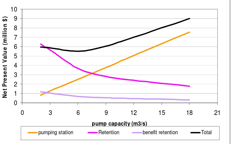
The optimal balance of pumping capacity and retention capacity is assessed on investment and operation and maintenance costs.
Figure 6 presents the relation between pump capacity and retention capacity for several safety levels. The economic optimal safety level for the internal water management system is T10, as described above. The water table is determined as 2 m below surface level, as described above, meaning a freeboard of 2 m. When the freeboard is known, the retention capacity in m3 can be expressed in hectares.
Figure 6Pump and retention capacity
The assessment of the retention and pump capacity is based on a Net Present Value for a lifetime of 50 years. This assessment is based on investment costs for a pumping station (expressed per m3) and retention basin (m2), land acquisition and resettlement costs and O&M costs. The retention basin also provides benefit because it can be used as fishpond. The benefits are taken into account as well.
1st International Conference on Infrastructure Development, UMS Surakarta, 1 – 3 Nov 2013 ISBN 978-979-636-154-4
Figure 7Pump Capacityand Net Present Value
CONCLUSION
A Polder system is and integrated system of elements, like the closed ring-dike, pumping station or sluice, retention basin, etc. The polder can not function properly without one of the elements. The design of the elements needs a integrated approach of the whole polder system first, such as determining the safety level and the optimal pump capacity and retention capacity. Besides the technical issues, the polder system requires an integrated institutional approach as well, since many stakeholders are approached PSDA, Bappeda, BBWS and major land owners, like Bina Marga and Kereta Api. With this integrated approach a sound polder system can be designed, protecting the inhabitants from Rob and Banjir and reducing the (yearly) damage enormously.
REFERENCES
Budinetro, H. S., S. Rahayu., 2010. Polder Banger Solusi Penanggulangan Banjir di Semarang. Prosiding Seminar Nasional dan Workshop“Pengelolaan Sungai Terpadu Menghadapi Perubahan Iklim”. Center for River Basin Organizations and Management, Solo, Central Java, Indonesia.
Budinetro, H. S., Sri, R., T. A. Praja., A. Taufiq., D. Kusnadi., dkk. 2011. Strategi Pengendalian Banjir Kota Semarang, Jurnal Sumber Daya Air Vol. 8. No. 2. Bandung
DeGarmo, P.E., J. R. Canada, W. G. Sulilivan, 1979. Engineering Economy. New York:Macmillan Publishing Co., Inc.
Gupta, B. L. 1979. Water Resources Engineering & Hydrology. Delhi: Standart Publisher Distribution. Linsley, R. K., J. B. Franzini., 1972. Water Resources Engineering. MacGraw-Hill Book Company, New
York.
Mondale, H., H. S. Budinetro. 2010. The Banger Polder in Semarang. CRBOM Small Publications Series No. 16, Center for River Basin Organizations and Management, Solo, Central Java, Indonesia (publised on the internet and promoted via CRBOM’s network)
Peters, R. 2012. Factors that Contribute to Effective Dutch-funded for International Water Project (A case study of Banger Pilot Project in Semarang, Indonesia)”, Thesis for Master Degree. Business Administration International Management, University of Twente The Netherlands (unpublished) Sawarendro. 2010. Sistem Polder & Tanggul Laut: Penanganan banjir secara madani di Jakarta.ILWI
(Indonesia Land Reclamation and Water Management Institute), Jogyakarta.
Simonovic, S. P. 2009. Managing Water Resources-Methods and tools for a Systems Approach.UNESCO Publishing. London.
1st International Conference on Infrastructure Development, UMS Surakarta, 1 – 3 Nov 2013 ISBN 978-979-636-154-4
225