THE USE OF SPATIAL MULTI CRITERIA ANALYSIS TO
SUPPORT SUSTAINABLE TOURISM PLANNING
A Case Study in Coastal Area of Bantul Regency Yogyakarta
JAKA SURYANTA
GRADUATE SCHOOL
ABSTRACT
Parangtritis Village is one of the smallest administrative boundary in the
Bantul Regency that has coast line, in which tourism is the main economic sector after
farming and agriculture. The limitations on space and the vulnerable ecosystem are
the first to be considered in the development of tourism. The main problems are the
conflict of land space utilization among stakeholders, government and community.
Therefore Spatial Multi Criteria Analysis to support sustainable tourism planning is
proposed. A GIS model has already been constructed with available data. Supporting
decision-making in a spatial context is implicit in the use of GIS but the analytical
capability of the GIS has to be enhanced to solve the problems, where Multi Criteria
Analysis comes in to play.
The objectives of this research are to access land suitability analysis purposes
for tourism, paddy field, identify conflict area and to determine the best alternative
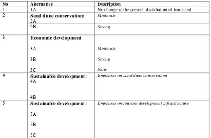
land use by Multi Criteria Analysis method. Eleven land use policy alternatives were
designed and evaluated to minimize conflict and to find the best alternative land use
based on the production orientation and environmental conservation.
The results of this research are area suitable for tourism, about 36.33% were of
highly suitable (S1), 32.88% of suitable (S2), 24.77% of marginally suitable (S3) and
6.00% of not suitable (N). The area suitable for paddy field which about 33.63% of
suitable (S2), 52.47% of marginally suitable (S3), and 13.89% of not suitable (N). The
conflict of interest based on land suitability are between the suitable S2 paddy field
and suitable S1 tourism of about 1.42%, S2 paddy field and suitable S2 tourism of
about 26,58%. The conflicts based on existing land use are the development of
hotel/infrastructure in the area of sand dune, the planting vegetation in sand dune to
protect paddy field. Some assessment criteria (sand dune conservation, economic
development and sustainable development) were defined and submitted to determine
the best alternative. The alternative 4b (sustainable development emphases on sand
dune conservation) has been found to be the best alternative. The second best was
alternative 3C (economic development) and the third best was alternative 5C
THE USE OF SPATIAL MULTI CRITERIA ANALYSIS TO
SUPPORT SUSTAINABLE TOURISM PLANNING
A Case Study in Coastal Area of Bantul Regency Yogyakarta
JAKA SURYANTA
A Thesis submitted for the degree of Master of Science of Bogor Agricultural University
MASTER OF SCIENCE IN INFORMATION TECHNOLOGY
FOR NATURAL RESOURCES MANAGEMENT
GRADUATE SCHOOL
Research Title : The Use of Spatial Multi Criteria Analysis to Support Sustainable Tourism Planning (A Case Study in Coastal Area of Bantul Regency Yogyakarta).
Name : Jaka Suryanta
Student ID : G050140131
Study Program : Master of Science in Information Technology for Natural Resources Management
Approved by, Advisory Board
Dr. Ir. Tania June, M.Sc Dr. Ir. Dewayany Sutrisno, MApp.Sc Supervisor Co-supervisor
Endorsed by,
Program Coordinator Dean of Graduate School
Dr. Ir. Tania June, M.Sc Prof. Dr. Ir. Khairil A. Notodiputro, M.Sc
STATEMENT
Hereby I, Jaka Suryanta, do declare that this thesis entitled “The Use of Spatial Multi Criteria Analysis to Support Sustainable Tourism Planning (A Case Study in Coastal of Bantul Regency Yogyakarta)” is my own work and has not been submitted in any form for another degree or diploma programs (course) to
any University or other institution. The content of the thesis has been examined by the
advising committee and the external examiner.
Bogor, December 2006
ACKNOWLEDGEMENTS
First of all, I would like to express my gratitude to God, who has blessing and
favor me success in my studies. I pay my heartfelt love and tribute to my beloved
wife, Wahyu Tjahjani and to our dear children’s Regina and Eriko for their patient and
support.
I would like to express my gratitude and sincerely appreciation to the following,
that contributed to my studies and success in one way or the other:
1. The Bakosurtanal Institution especially Center for Marine Resources Survey
and Mapping for granting me fellowship to study in MIT Biotrop IPB Bogor
Indonesia;
2. Dr. Tania June my research supervisors for all their valuable guidance and
usefull advise during my MSc proposal preparation and MSc thesis writing;
3. Dr. Dewayani Sutrisno, MAppSc, my research coo-supervisors for all their
valuable guidance and useful advice during my MSc proposal preparation and
MSc thesis writing;
4. Dr. Gatot Haryo Pramono as the external examiner of this thesis and for his
positive ideas and inputs.
5. Drs. Suwahyuono, MSc, my student advisor for all his support and
encouragement;
6. Special thanks go to all the members of lecturers and staff in MIT Biotrop IPB
Bogor;
7. Dr. Antonius Bambang Wijanarto for his guidance and technical commands
during thesis writing; and
8. Finally, I thank my fellow MSc in IT for NRM students-2003 for the
wonderful student working relations we shared together. I will always
appreciate all the memories and happiness we shared together in class,
CURRICULUM VITAE
The author was born in Klaten, Central Java on May 28th 1963, Indonesia. He is
the youngest son of Sriyanto Hardjo and Sriyatin. He finished his Elementary, Junior,
and High school in Public School, Klaten. He was received undergraduate diploma
from Gadjah Mada University, Faculty of Geography in field of Hydrology in 1991.
Since 1992 to present, he works at the Agency for Surveying and Mapping
(Bakosurtanal) Bogor Indonesia.
In 2004, he was received a scholarship to study Master Science in Information
TABLE OF CONTENTS
STATEMENT ON THESIS ... i
ACKNOWLEDGEMENTS ... ii
CURRICULUM VITAE ...iii
ABSTRACT... iv
TABLE OF CONTENTS... v
LIST OF TABLES ...viii
LIST OF FIGURES ... ix
LIST OF APPENDICES... x
1 I INTRODUCTION ... 1
1.1 Background... 1
1.2 Problem definition ... 3
1.3 The objectives... 4
1.4 Output ... 4
1.5 Scope of Research ... 5
2 II LITERATURE REVIEW... 6
2.1 Coastal Zone ... 6
2.2 Sand dune ... 6
2.3 Sustainable Tourism ... 8
2.4 Planning Principle ... 9
2.5 Planning Techniques ... 11
2.6 Planning Measure Techniques... 12
2.7 Geographic Information System (GIS) ... 13
2.8 Spatial Decision Support Tool... 14
2.9 The previous research... 15
3 III GENERAL DESCRIPTION OF THE AREA ... 16
3.2 Physical aspects ... 17
3.2.1 Soil type and Topography ... 17
3.2.2 Climate ... 18
3.2.3 Water Resource Potentials... 18
3.3 Sand dune in Parangtritis... 19
3.4 Flora and fauna ... 20
3.5 Profile of Population... 20
3.5.1 Education ... 20
3.5.2 Employment ... 21
3.6 Tourism object... 21
3.6.1 Cultural Tourism ... 22
3.6.2 Natural Tourism... 23
3.6.3 Educational Tourism ... 23
3.7 The visitors ... 24
3.8 Original Regional Revenue (Pendapatan Asli Daerah) ... 25
4 IV METHODOLOGY ... 26
4.1 Frame work... 26
4.2 Research steps ... 27
4.2.1 Existing Land-use map ... 28
4.2.2 Ground checking ... 29
4.2.3 Land Suitability Analysis ... 30
4.2.3.1 Weighting and scoring... 32
4.2.3.2 Areas of Conflict ... 33
4.2.4 Creating Maps of Alternative ... 33
4.2.5.1 Formulation of Policy Alternatives ... 35
4.2.5.2 Assessment Criteria ... 36
4.2.5.3 Comparison of alternatives... 37
4.3 Data requirement and Equipment used... 37
4.4 Hardware, software and equipment ... 38
5 V RESULT AND DISCUSSION ... 39
5.1 Existing land use... 39
5.2 Land Suitability ... 40
5.2.1 Land suitability for tourism area ... 40
5.2.2 Land Suitability for Paddy... 41
5.2.3 Land Suitability for Corn... 42
5.3 Priority of Land Use Planning ... 43
5.3.1 Conflict on space utilization ... 43
5.3.2 Formulation of Policy Alternatives ... 45
5.3.3 Assessment criteria ... 48
5.3.4 Comparison of Alternatives Using MCA ... 49
5.3.5 Recommended Tourism Land Use Planning ... 55
6 VI CONCLUSION AND RECOMMENDATION ... 56
6.1 Conclusion ... 56
6.2 Recommendations ... 57
THE USE OF SPATIAL MULTI CRITERIA ANALYSIS TO
SUPPORT SUSTAINABLE TOURISM PLANNING
A Case Study in Coastal Area of Bantul Regency Yogyakarta
JAKA SURYANTA
GRADUATE SCHOOL
ABSTRACT
Parangtritis Village is one of the smallest administrative boundary in the
Bantul Regency that has coast line, in which tourism is the main economic sector after
farming and agriculture. The limitations on space and the vulnerable ecosystem are
the first to be considered in the development of tourism. The main problems are the
conflict of land space utilization among stakeholders, government and community.
Therefore Spatial Multi Criteria Analysis to support sustainable tourism planning is
proposed. A GIS model has already been constructed with available data. Supporting
decision-making in a spatial context is implicit in the use of GIS but the analytical
capability of the GIS has to be enhanced to solve the problems, where Multi Criteria
Analysis comes in to play.
The objectives of this research are to access land suitability analysis purposes
for tourism, paddy field, identify conflict area and to determine the best alternative
land use by Multi Criteria Analysis method. Eleven land use policy alternatives were
designed and evaluated to minimize conflict and to find the best alternative land use
based on the production orientation and environmental conservation.
The results of this research are area suitable for tourism, about 36.33% were of
highly suitable (S1), 32.88% of suitable (S2), 24.77% of marginally suitable (S3) and
6.00% of not suitable (N). The area suitable for paddy field which about 33.63% of
suitable (S2), 52.47% of marginally suitable (S3), and 13.89% of not suitable (N). The
conflict of interest based on land suitability are between the suitable S2 paddy field
and suitable S1 tourism of about 1.42%, S2 paddy field and suitable S2 tourism of
about 26,58%. The conflicts based on existing land use are the development of
hotel/infrastructure in the area of sand dune, the planting vegetation in sand dune to
protect paddy field. Some assessment criteria (sand dune conservation, economic
development and sustainable development) were defined and submitted to determine
the best alternative. The alternative 4b (sustainable development emphases on sand
dune conservation) has been found to be the best alternative. The second best was
alternative 3C (economic development) and the third best was alternative 5C
THE USE OF SPATIAL MULTI CRITERIA ANALYSIS TO
SUPPORT SUSTAINABLE TOURISM PLANNING
A Case Study in Coastal Area of Bantul Regency Yogyakarta
JAKA SURYANTA
A Thesis submitted for the degree of Master of Science of Bogor Agricultural University
MASTER OF SCIENCE IN INFORMATION TECHNOLOGY
FOR NATURAL RESOURCES MANAGEMENT
GRADUATE SCHOOL
Research Title : The Use of Spatial Multi Criteria Analysis to Support Sustainable Tourism Planning (A Case Study in Coastal Area of Bantul Regency Yogyakarta).
Name : Jaka Suryanta
Student ID : G050140131
Study Program : Master of Science in Information Technology for Natural Resources Management
Approved by, Advisory Board
Dr. Ir. Tania June, M.Sc Dr. Ir. Dewayany Sutrisno, MApp.Sc Supervisor Co-supervisor
Endorsed by,
Program Coordinator Dean of Graduate School
Dr. Ir. Tania June, M.Sc Prof. Dr. Ir. Khairil A. Notodiputro, M.Sc
STATEMENT
Hereby I, Jaka Suryanta, do declare that this thesis entitled “The Use of Spatial Multi Criteria Analysis to Support Sustainable Tourism Planning (A Case Study in Coastal of Bantul Regency Yogyakarta)” is my own work and has not been submitted in any form for another degree or diploma programs (course) to
any University or other institution. The content of the thesis has been examined by the
advising committee and the external examiner.
Bogor, December 2006
ACKNOWLEDGEMENTS
First of all, I would like to express my gratitude to God, who has blessing and
favor me success in my studies. I pay my heartfelt love and tribute to my beloved
wife, Wahyu Tjahjani and to our dear children’s Regina and Eriko for their patient and
support.
I would like to express my gratitude and sincerely appreciation to the following,
that contributed to my studies and success in one way or the other:
1. The Bakosurtanal Institution especially Center for Marine Resources Survey
and Mapping for granting me fellowship to study in MIT Biotrop IPB Bogor
Indonesia;
2. Dr. Tania June my research supervisors for all their valuable guidance and
usefull advise during my MSc proposal preparation and MSc thesis writing;
3. Dr. Dewayani Sutrisno, MAppSc, my research coo-supervisors for all their
valuable guidance and useful advice during my MSc proposal preparation and
MSc thesis writing;
4. Dr. Gatot Haryo Pramono as the external examiner of this thesis and for his
positive ideas and inputs.
5. Drs. Suwahyuono, MSc, my student advisor for all his support and
encouragement;
6. Special thanks go to all the members of lecturers and staff in MIT Biotrop IPB
Bogor;
7. Dr. Antonius Bambang Wijanarto for his guidance and technical commands
during thesis writing; and
8. Finally, I thank my fellow MSc in IT for NRM students-2003 for the
wonderful student working relations we shared together. I will always
appreciate all the memories and happiness we shared together in class,
CURRICULUM VITAE
The author was born in Klaten, Central Java on May 28th 1963, Indonesia. He is
the youngest son of Sriyanto Hardjo and Sriyatin. He finished his Elementary, Junior,
and High school in Public School, Klaten. He was received undergraduate diploma
from Gadjah Mada University, Faculty of Geography in field of Hydrology in 1991.
Since 1992 to present, he works at the Agency for Surveying and Mapping
(Bakosurtanal) Bogor Indonesia.
In 2004, he was received a scholarship to study Master Science in Information
TABLE OF CONTENTS
STATEMENT ON THESIS ... i
ACKNOWLEDGEMENTS ... ii
CURRICULUM VITAE ...iii
ABSTRACT... iv
TABLE OF CONTENTS... v
LIST OF TABLES ...viii
LIST OF FIGURES ... ix
LIST OF APPENDICES... x
1 I INTRODUCTION ... 1
1.1 Background... 1
1.2 Problem definition ... 3
1.3 The objectives... 4
1.4 Output ... 4
1.5 Scope of Research ... 5
2 II LITERATURE REVIEW... 6
2.1 Coastal Zone ... 6
2.2 Sand dune ... 6
2.3 Sustainable Tourism ... 8
2.4 Planning Principle ... 9
2.5 Planning Techniques ... 11
2.6 Planning Measure Techniques... 12
2.7 Geographic Information System (GIS) ... 13
2.8 Spatial Decision Support Tool... 14
2.9 The previous research... 15
3 III GENERAL DESCRIPTION OF THE AREA ... 16
3.2 Physical aspects ... 17
3.2.1 Soil type and Topography ... 17
3.2.2 Climate ... 18
3.2.3 Water Resource Potentials... 18
3.3 Sand dune in Parangtritis... 19
3.4 Flora and fauna ... 20
3.5 Profile of Population... 20
3.5.1 Education ... 20
3.5.2 Employment ... 21
3.6 Tourism object... 21
3.6.1 Cultural Tourism ... 22
3.6.2 Natural Tourism... 23
3.6.3 Educational Tourism ... 23
3.7 The visitors ... 24
3.8 Original Regional Revenue (Pendapatan Asli Daerah) ... 25
4 IV METHODOLOGY ... 26
4.1 Frame work... 26
4.2 Research steps ... 27
4.2.1 Existing Land-use map ... 28
4.2.2 Ground checking ... 29
4.2.3 Land Suitability Analysis ... 30
4.2.3.1 Weighting and scoring... 32
4.2.3.2 Areas of Conflict ... 33
4.2.4 Creating Maps of Alternative ... 33
4.2.5.1 Formulation of Policy Alternatives ... 35
4.2.5.2 Assessment Criteria ... 36
4.2.5.3 Comparison of alternatives... 37
4.3 Data requirement and Equipment used... 37
4.4 Hardware, software and equipment ... 38
5 V RESULT AND DISCUSSION ... 39
5.1 Existing land use... 39
5.2 Land Suitability ... 40
5.2.1 Land suitability for tourism area ... 40
5.2.2 Land Suitability for Paddy... 41
5.2.3 Land Suitability for Corn... 42
5.3 Priority of Land Use Planning ... 43
5.3.1 Conflict on space utilization ... 43
5.3.2 Formulation of Policy Alternatives ... 45
5.3.3 Assessment criteria ... 48
5.3.4 Comparison of Alternatives Using MCA ... 49
5.3.5 Recommended Tourism Land Use Planning ... 55
6 VI CONCLUSION AND RECOMMENDATION ... 56
6.1 Conclusion ... 56
6.2 Recommendations ... 57
LIST OF TABLES
Table 3.1 The soil type in the area of research ... 17
Table 3.2 Annual debit flow of Opak River, Bantul Yogyakarta ... 18
Table 3.3 Flora and fauna in Parangtritis... 20
Table 3.4 Population and education... 21
Table 3.5 Population and Employment... 21
Table 3.6 Type of objects Tourism in Parangtritis... 22
Table 3.7. The visitors ... 24
Table 3.8 The resume of the determination of tax revenue ... 25
Table 4.1 Matrix for suitability of land coastal tourism activities ... 30
Table 4.2 Criteria land suitability for paddy field... 31
Table 4.3 Criteria land suitability for corn... 31
Table 4.4 The designed policy alternative according to the tree policy objective... 36
Table 4.5 Assessment criteria of the policy objectives... 37
Table 4.6 Hardware, software and equipment. ... 38
Table 5.1 The existing land use ... 40
Table 5.2 Land suitability for tourism. ... 41
Table 5.3 Land suitability for Paddy... 41
Table 5.4 Land suitability analysis for Corn... 42
Table 5.5 Conflict matrix suitability for Corn, Paddy and Tourism (ha) ... 44
Table 5.6. Existing land use (ha) cross with conflict matrix tourism and paddy... 45
Table 5.7 The policy alternative and description... 46
Table 5.8 Area of each land alternatives map (ha) ... 48
Table 5.9 Assessment criteria ... 48
Table 5.10 Quantification of Assessment Criteria per land used category... 49
Table 5.11 Effect table for land used alternatives... 50
Table 5.12 Priority ranking of effect of policy schemes... 51
Table 5.13 Result of the ranking Alternative base on policy schemes Table 5.12 ... 51
LIST OF FIGURES
Figure 1.1 The area of study in Parangtritis Village, Bantul, Yogyakarta... 5
Figure 2.1 Major crescentric dune forms ... 7 Figure 2.2 Major linear dune forms ... 7
Figure 2.3 Relationship between wind velocity and sand movement... 8
Figure 3.1 Annual debit flow of Opak river, Bantul, Yogyakarta. ... 18
Figure 4.1 Diagram of research framework. ... 27
Figure 4.2 Research Steps... 28
Figure 4.3 Land use mapping diagram. ... 29
Figure 4.4 Flowchart of Multi Criteria Analysis. ... 35
Figure 5.1 Existing land use map of Parangtritis. ... 39
Figure 5.2 Land suitability map for tourism of Parangtritis Village... 40
Figure 5.3 Land suitability map for paddy... 42
Figure 5.4 Land suitability map for corn. ... 43
Figure 5.5 Conflict map suitability for Corn, Paddy and Tourism. ... 44
Figure 5.6 Alternatives land use map. ... 48
Figure 5.7 Rank number of the alternative. ... 52
Figure 5.8 Relocation the building that disturb establishment of sand dune. ... 53
Figure 5.9 Examples of building that need improvement... 53
LIST OF APPENDICES
Appendix .1.
Appendix .2.
Appendix .3.
Appendix .4.
Appendix .5.
Appendix .6.
Appendix .7.
Calculation of Efect table for each alternative
Example of Stepping Process MCA
Determination of tourism tax revenue by DISPARDA Bantul
Land use map of alternative 3c
Land use map of alternative 5c
Tourism Object and Zone of Land use
Examples of Sand dune
60
63
69
71
72
73
1
I INTRODUCTION
1.1Background
Sustainable tourism planning is a planning based on the maintenance of a
balance where tourism runs at a profit but not at expense of the natural, cultural, or
ecological resources (IFTO, 1994 in Holden, 2001). Therefore, to survive and thrive
for a long term basis, tourism industry is obliged to preserve the environment.
Promoting sustainable tourism development in the Province of Daerah Istimewa
Yogyakarta is one of the objectives of Agenda 21 of Yogyakarta in which tourism was
selected to be the first Regional Agenda 21 of Yogyakarta.
Tourism has large and extensive multiplier effects and may create new job
opportunities. Tourism has positive impacts for local income, employment, scientific
and tax revenues (PAD), however, some negative impact may also exist. The negative
impacts are for examples, degraded environment and culture. These impacts are
determined by a variety of factors, such as the extent of tourist zone use, the resilience
of ecosystems, and the size of zone. The smaller the size of the tourism area, it is
likely to impose more effects on the environment and culture. Basically, positive
impacts are more to be considered, therefore it is not surprising that local or national
governments attempt to maximize their coastal tourism potential through promotional
campaigns, increasing tourist facilities and enhancing air and sea links (Briguglio &
Briguglio, 1996).
The government is aware that the sustainability of the tourist industry has been
threatened by overused and inappropriate spatial planning, for example; (a)
swimming pool, and (c)Parangtritis beach, where the beach and ocean view have been
obscured by hotel, settlement, shops and parking lots that utilized the area of sand
dune (UNDP,2003). Therefore, the Agenda 21 of Sustainable Tourism Development
DIY has one of important missions i.e. to rehabilitate these conditions to reach the
sustainable resource utilization.
For managing the tourism industry, spatial planning is one of the solutions to
be taken into consideration. According to Williams (1998:111), spatial zoning is an
established land management strategy that aims to integrate tourism into sustainable
area by defining areas of land due to the suitability’s or capacities for tourism. Hence,
zoning of land may be used to exclude tourists development facilities from primary
conservation areas, to focus general visitors into a limited number of locations where
their needs may be met and their impacts may be controlled and managed. It uses
some kind of spatial data themes that are collected through inventorying, storing,
attributing, and analyzing. In this case remote sensing technology was used for spatial
data collection and inventory of coastal ecosystem condition.
Geographic Information System (GIS) allows the matching of recreation
potential with the characteristics of the regions. The capability of a GIS to allow rapid
modification, addition or removal of constraints and to investigate the complex
interrelations between the thematic layers is attractive for resources management and
planning.
In some cases, conflicts of interest of different stakeholders exist and need to
be assessed with the output best for the region. Spatial multi criteria analysis may be
employed for the study. Spatial Multi Criteria Analysis Method offer the analytical
multi-criteria. Spatial Multi Criteria Analysis is a conjunctive application of Remotely
Sensed data, Geographic Information System and Multi Criteria Analysis
Technologies, which is very important in assisting decision makers choose the best
decision on complex problems.
This research employs spatial multi criteria analysis to assist spatial planning
in Parangtritis Land Coastal Tourism Area.
1.2Problem definition
Decision makers often faced by conflicting interests resulting from various
existing or planned activities of different stakeholders. The government of Bantul
Regency faces similar problem in managing Parangtritis tourism area, where path of
the sand dune conservation zone to be used for settlement, hotel and some plantation.
The effort to minimize deviation in space utilization must be done, to prevent
deterioration of existing tourism zone. The trend of increasing visitor will use more
space of land; it can be anticipated through exploiting alternative site or expanding
tourism zone.
Data aerial photos in 1992, aerial photos in 2000 and quick bird image in 2003
clearly show that the expansion of the settlement and hotel is about 11%. The problem
is that about 3% of development was situated in the area of sand dune conservation.
The other problems are vegetation that grows and the planting that causes to be
passive sand dune.
The policy documents concerning sand dune conservation/ rehabilitation and
utilize land for other purpose i.e.: hotel, settlement and agriculture need proper
consideration, so the conflict will be reduced and avoided. Studying the conflict is
analysis is conducted through Geographical Information System in evaluating the
situation to obtain tourism suitability. The spatial planning is basically the formulation
of space utilization in optimum way, based on production orientation and
environmental conservation. According to the problem, it is necessary to make
problem definition on how to use spatial multi criteria analysis for land coastal
tourism planning. The most important propositions of this study are:
how to determine the land suitability by obtaining land characteristics and land
use or land cover using remote sensing and GIS,
how to get the best policy of land use alternative for tourism development
using spatial multi criteria decision making, and
how to create the land coastal tourism zone according to the best policy, which
is being defined.
1.3The objectives
The objectives of this research are:
• to carry out the suitability assessment for tourism area,
• to identify the conflicting area,
• to asses the conservation zone of sand dune and other tourism object, and
• to asses the policy option of tourism development.
1.4Output
The outputs of this research are:
• Land suitability map for tourism area,
• Alternative maps based on scenario created to develop tourism planning, and
1.5Scope of Research
Research site is Parangtritis village, which is geographically located between
110 o 16’30’’ - 110 o 21’00’’ East and 07 o 16’30’’ - 08 o 02’00’’ South. The research
area is focused on coastal land, while the coastal marine were not included due to the
strong wave and steep slope of the sea bottom.
Parangtritis Village covers an area of 967,201 hectares consisting of 11 sub
villages. Administratively, Parangtritis is bounded by Donotirto Village n the northern
part, Selohardjo Village in the eastern part, Tirtohardjo Village in the western part and
Indian Ocean in the southern part. This research used a base map at 1: 25.000 scale.
Figure 1.1. shows Parangtritis area in the Province of Daerah Istimewa Yogyakarta.
ADMINISTRATIVE BOUNDARY OF PARANGTRITIS VILLAGE
Legend :
1 0 1 2 Kilometers
Administrative boundary Giricahyo Village Girijati Village Indian Ocean Parangtritis Village Seloharjo Village Srigading Village Tirtohargo Village Tirtoharjo Village Giriasih Village
Based map derived from Indonesia Topographic Map at 1 : 25.000 scale, produced by Bakosurtanal in 1998
Primary road Secondary road Tertiary road Footpath raod N 8° 1 '40
" 8°1
'4 0 " 8°0 0 '3 0
" 8°0
0 '3 0 " 7° 5 9 '2 0
" 7°5
9 '2 0 " 110°17'30" 110°17'30" 110°18'40" 110°18'40" 110°19'50" 110°19'50" PARANGTRITIS VILLAGE
D IY
2
II LITERATURE REVIEW
2.1Coastal Zone
Coastal zone is the area, on both sides of the actual land – water interface, where
the influences of land and water on each other are still a determining factor-
climatically, physiographically, ecologically, or economically (Fedra, et al., 1998).
Base on the geomorphologic map (Westi, 2005), Parangtritis beach is divided
into four types of coastal geological landscapes. There are tectonic cliffs, coastal
watershed floodplain, coastal marine, and coastal sand dune.
The sand dune is distinguished in to tree zone such as the wetland (Sea, Laguna
and Opak river), active sand dune characterized by tide area and open beach. The last
one is passive sand dune that is covered by naturally vegetation, culture vegetation
and settlement.
The object tourism takes place in all the types of landscapes. Open beach that is
dominated by sandy area is very famous place used for tourism. Usually, the grains
sand comes from the dead coral or it came from up land (volcanoes) and by moving
water the sands in the river move and deposit to the estuary. Sea current moves sand
grains then throw up by the wave to the beach. The next process is that the wind
moves the sands then the sands are accumulated as sand dune.
2.2Sand dune
Wind is an agent of geomorphic change. The work of the wind are erosion,
transportation and deposition called Aeolian (Christoperson.1998). A dune is a wind –
sculpted accumulation of sand. Sand grains are generally deposited as transient ridges
north Africa, is the characteristics of an erg desert, or sand sea. The grand erg oriental
in the central Sahara exceeds 1200 m in depth and cover 192 000 km2. This sand sea
has been active for more than 1.3 million years and has average dune heights of 120
m.
Dunes have many wind-shaped styles that make classification difficult. Dune
can simply be classified in to three classes: crescentric (exp: barchans, parabolic), linear (exp; longitudinal, sweep) and star dunes. Figures 2.1 and 2.2 show some types
of sand dune.
Figure 2.1 Major crescentric dune forms
Sand dune is a scarce land form (endangered landscape) usually take place in the
beach, unfortunately competition for access to sandy beaches inevitability caused
changes in the natural environment at present.
The process of sand dune formation is influenced by available abundant of sand
grains, win as agent of grains sand motion and deposition, the clear distinguish of wet
and dry season, no material that close the space where the sand dune will be formed
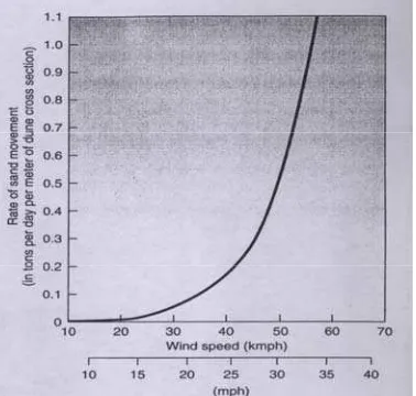
(Debyosaputro,1997). The relationship between wind velocity and sand movement for
[image:31.595.237.426.306.486.2]sand dune formation shows in Figure 2.3.
Figure 2.3 Relationship between wind velocity and sand movement 2.3Sustainable Tourism
In the Earth Summit, a program for promoting sustainable development
throughout the world, known as Agenda 21, was adopted by participating countries.
Although tourism as an economic sector was not debated in Rio, five year later in the
Earth Summit II in New York, it was debated as a recognized economic sector.
In the report, some recommendations and outcomes were stated as follows. The
expected growth in the tourism sector and the increasing reliance of many developing
employer and contributor to local, National, Sub regional and regional economies
highlights the need for attention to the relationship between environmental
conservation and protection and sustainable tourism.
Tourism industry has adopted sustainability for three reasons: economic, public
relations and marketing (Butler,1998). The five main goals of sustainable tourism
were identified as:
a. to develop greater awareness and understanding of the significant
contributions that tourism can make to the environmental economy,
b. to promote equity and development,
c. to improve the quality of life of the host community,
d. to provide a high quality of experience for the visitor, and
e. to maintain the quality of the environment on which the foregoing objective
depend.
Others said that tourism should not degrade the resource and should be
developed in an environmentally sound manner. It should involve education among all
parties, local communities, government, non government organization and tourists
before and after trip. It should provide long-terms benefits – to the resources, to the
local community, and to industry (benefits may be conservation, scientific, social,
cultural or economic) (Butter, 1991).
Tourism operations should ensure that the underlying ethics of responsible
environmental practices are applied not only to the external (natural and cultural)
resources, which attract the tourists, but also to their internal operations.
2.4Planning Principle
Utilization Guidance and Method for Controlling the space utilization. The spatial
planning is basically the formulation of space utilization in optimum away based on
production orientation and environmental conservation. The technical requirement for
spatial utilization in general or can be nationally implemented was not identified yet.
The following principles plan (UNDP, 1999) can be used when preparing
management plan:
¾ Plan must be objective oriented: When the problems or issues are understood, a set
of objectives should be framed to address key issues. Objectives should be
quantifiable targets that serve to focus management effort and measure
performance.
¾ Plan must try to achieve the greatest good for the greatest number of people in the
long run: Minority interest must be weighed in relation to the general well being of
larger communities.
¾ The ecological carrying capacity should never be exceeded and resources
sustainability should be given high priority: This is a non-negotiable requirement,
if sustainable production is to be achieved.
¾ The need for the conservation of biological diversity and wildlife should be
recognized.
¾ Planning is on going dynamic process: Planning must be flexible enough to
accommodate shifts in demand/supplies and priorities. Because societal values
change over time, planning is an on-going dynamic process.
¾ The plan must provide for improvements in data collection to reduce areas of
uncertainty associated with an incomplete or weak information base: The ultimate
information base over time and applying a conservative approach where the
uncertainty is perceived to be great.
¾ The decision-making process must be visible and equitable: Involving the public
in the decision-making process is necessary to promote local support and
acceptance for integrated coastal management planning. Decision-making should
not marginalize the traditional incomes of local people nor their access to
reasonable amount of coastal products without offering practical and acceptable
alternative.
Regulation and laws that are based on sector’s interest and not operational part
of reasons allow the deviation occurred in space utilization from the current spatial
use plan. Deviation in space utilization from spatial use plan is potential toward
conflict in space utilization. Studying the conflict is carried out through spatial
analysis and conflict analysis approaches. The spatial analysis is conducted through
Geographic Information System in evaluating the situation to obtain tourism
suitability.
2.5Planning Techniques
All planning process begin with some study of existing characteristics of land
and development. Often this is called inventory. Regional studies often begin with
lists of services and facilities –number and categories of lodging , food service and
attractions. Others begin with statistics on economic impact-numbers of people
employed in tourism, income and tax revenues produced. Still others identify a broad
range of resources factors, both natural and cultural.
Tourism inventory focuses as foundation for future policy and planning by both
Tourism Resource Inventory Project (CTRIP) by British Columbia (1991) are:
1. To develop and implement a rigorous and credible tourism resource mapping
methodology that:
¾ identifies and maps tourism resources based on the needs and expectation of
tourism operator and consumers;
¾ reflect the present and future resource needs of the coastal tourism industry;
¾ document existing tourism resource use and infrastructure;
¾ respect, where appropriate , the need for confidentially of data and;
¾ is compatible with emerging local or provincial government geographic
information system standard.
2. To ensure that the inventory provides a cost effective tool to support tourism
planning and specifically:
¾ enables the derivation of tourism resource values in a credible and technically
sound manner;
¾ highlights areas requiring land and resource use protection and or management to
maintain present and future tourism development option;
¾ increases the capacity of the ministry to present tourism interest in integrated
resource management processes and;
¾ provides the basis for preparation of a coastal tourism plan.
2.6Planning Measure Techniques
There are a variety of other land-use planning measure that can be encouraged
by government to mitigate the negative effects of tourism. Zoning can provide a
proper recognition of resources that exist in the area and subsequently identify where
protected areas the WTO (1992) remark: a protected area can be divided into zones of
strict protection (a ‘sanctuary zone’, where people are excluded), wilderness (where
visitors are permitted only on foot), tourism ( where visitors are encouraged in various
compatible ways), and development where facilities are concentrated’.
Example of land use zoning takes place in The Canadian National Park system.
Five zones have been designated for application in the national park, categorized by
resource base of the area and the amount of recreational access that is allowed there:
Zone1: Special preservation- areas that contain strictly protected rare or endangered
species and where access is strictly controlled;
Zone2: Wilderness –areas that use only dispersed with limited facilities;
Zone3: Natural environment- this area acts as buffer zone between zones 2 and 4, and
access is primarily non-motorized;
Zone4: Recreation- overnight facilities such as campsites are concentrated
Zone5- Park services- this area is highly modified providing many services but
represent less than 1 percent of the Tourism resort.
2.7Geographic Information System (GIS)
GIS is a set of computer tools designed to efficiently capture, store, update,
manipulate, analyze, and display all forms of geographically reference information
(ESRI 1992). The power of a GIS steams from its ability to combine many data sets
and display them in a common framework as thematic maps (Fedra and Feoly, 1998).
Users will expect to get support from the system to enter data, to analyze it in various
ways and to produce presentation on map. By GIS technology, the integration of all
methods and tools can be useful to establish a decision support system for spatially
GIS is widespread acceptance as a tool for decision support in land,
infrastructure, resources, environmental management and spatial analysis, and in
urban and regional development planning. GIS use an extensive background in the
digital data management, mapping sciences and information technology, because this
technology is built upon very broad base of scientific disciplines ranging from
cartography, remote sensing, computer science, statistics and so on. Recently,
development of GIS software and Web Technology has made more user-friendly,
therefore useable and accessible to more user (Gerrtman 2002, Sharifi, 2002).
2.8 Spatial Multi Criteria Analysis
Spatial Multi Criteria Analysis is a conjunctive application of Remotely Sensed
data, GIS and MCA Technologies. The potential of remotely sensed materials to
contain immense data/information from remote areas, coverage of large area in a
cheaper way relative to the data captured, renders them to be cost effective and time
saving. Therefore, remotely sensed products may be viewed as instruments of trust
among stakeholders, even the local communities because of the above reason.
GIS on its own offers limited application potential for use in ill-structured
complex community based natural resources management decision problem where
multiple and conflicting criteria and objectives are great concern. The use of GIS
alone in participatory decision-making would provide a real challenge on how to
incorporate local conflict in to the decision process especially those arising from more
qualitative perceptions of space place, locality and relationship between ecological
and socio-economic concerns of difference stakeholders.
MCA is a multiple criteria decisions making technique to assist the
provides very limited application potential for ill-structured complex community
based natural resources management decision problems with strong spatial
component. Using MCA alone would present a real challenge for participants to
visualize the spatial dimensions of the decision problem. These limitation can be
overcome by the integration of GIS and MCA.
2.9The previous research
Spatial Multi Criteria Analysis has ever been applied for the coastal
management in Rayong Province Thailand by Joan Looijen, Netatua Pelesikoti and
Marc Staljanssens. The main problem is conflict interest between mangrove forest
conservation and the development of shrimp culture in mangroves. The objectives
were to analyze the conflict of interest, to apply suitability assessment, to identify
areas of conflict, to formulate policy alternatives, and to compare the alternatives
using different policy schemes. By using Multi Criteria Analysis method the best
alternative land use were derived.
The same method will be tested to apply in land coastal of Parangtritis Bantul
Yogyakarta. The existing land uses are mainly for tourism and farming. The problem
are different, they are the conflict between sand dune conservation and development
of tourism/infrastructure, and utilize of land for paddy field and others. This situation
are challenges on how the use of Spatial Multi Criteria Analysis for land coastal
3
III GENERAL DESCRIPTION OF THE AREA
3.1Introduction
The President’s Decree number 22 /1999 about regional autonomous give more
authorities to the local government. This has impact on the way each local government
to develop their own activities. However, there are negative impacts that need
considerations. Many of the local governments have perceived this decree in the
wrong way. Because of the bigger authority they attempt to manage their territory to
increase as much regional income as they can, causing uncontrolled resource
exploitation.
Bantul Regency is one of the autonomous regions in Yogyakarta that has many
potential resources, dominated by agricultural sector, while tourism is another
potential sector that has given contribution in gaining regional income. Parangtritis is
one of the tourism areas in Bantul that has contributed the most income from tourism
sector in Bantul.
Nowadays, Parangtritis is characterized by its uncontrolled development and
mismanagement; the area has become a slum of tourism resort. The main interesting
parts of Parangtritis tourism object are sandy beach and sand dunes. Unfortunately, the
site is also surrounded by hotels, settlement, rest rooms, and unorganized parking lots.
If no special attention to this growing site, there will be deterioration and decrease in
tourism value, and may decrease in the number of visitors. Hence, there is a need for a
sustainable development in this area that may benefit for longer term not only for
investors, but also for local community and government.
The important factors that should be considered for the development of
of land capability, land capacity and the core of the tourism itself. According to the
local government vision in tourism planning (RTOW, 2003), the development should fulfil
four principles, these are balanced growth of local socio-economic-cultural condition,
balanced growth of conservation and development (spatial principle), good access of public
amenities for everyone, and democratic local-based governance system.
3.2Physical aspects
3.2.1Soil type and Topography
The topographic condition are situated at elevation ranging from 0 m mean sea
level to the highest of 250 m of mean sea level with the slope varying form flat (<1%)
to steep (>45%). Soil condition is one of the contributing factors, where the only
certain types of vegetation can grow. Table 3.1 shows six soil type, materials contents
and topographic. Two of them ‘ustipsamments and isohipotermik’ are closer to the coast line with the matter of sand and topographic flat to undulating. Its recent soil
that no deference of soil horizon and minimize organic matter mean while only
vegetation type of grass and bush survived. Typhic trophorthents soil type have been
threatened by local community, added organic matter, water irrigated and planted with
paddy. Other soil types were used for settlement, cultivation and dry culture.
Table 3.1 The soil type in the area of research
Soil type Material Tophographic
Ustipsamments,
Isohipertermik
Sand coastal sedimentary
Sand win sedimentary
Flat to undulate
Typhic trophorthents, Clay coluvial Flat to undulate
Lithic ustropepts Clay and limestone Hilly to steep
Lithic ustorthents Breksi and Tufa andesit Hilly to steep
Hypic Haplustalfs Clay sedimentary and sand Flat to undulate
3.2.2Climate
The Parangtritis area is belongs to climate “Type Am” (based on Schmidt
Fergusson), with an average rainfall intensity of 1,845 mm/year. The highest
temperature is 29.9o C, lowest temperature is 24.5o C and the average is 27.2o C. The
maximum humidity is 89% and the lowest humidity is 78% with wind velocity of 5 –
30 knot/second. There is clear distinction of wet and dry season, where the rainy
season is within November/December to March/April.
3.2.3Water Resource Potentials
The depths of ground water vary between 3 – 7 m in the low land and more
than 15 m in the high land. Base on the hydrogeology map of Yogyakarta the ground
water resource potentials are categorized in to medium to height.
The flow of surface water mainly goes through Opak River as a permanent
river. The average annual debit flow based on the station of automatic water level
recorder (AWLR) location at about 3 km north of Parangtritis is shown in Table 3.2
and Figure 3.1.
Table 3.2 Annual debit flow of Opak River, Bantul Yogyakarta
Month Jan Feb Marc Apr May Jun July Aug Sept Oct Nov Desc
Debit flow m3/det 60,3 68,1 158,0 73,6 24,2 12,9 11,0 7,10 3,93 2,43 5,96 11,8
Height mm 140 158 365 171 56,1 30,0 25,5 16,4 9,09 5,62 13,8 29
Sources: Research Institute for Water Resources Development. Bandung 1998.
0 50 100 150 200 250 300 350 400
Jan Feb Marc Apr May Jun Jul Augus Sept Oct Nov Desc Debit m 3/det
Height m m
The suspended load is mainly grains sand and dash from volcanic activity of
Mount Merapi. The debit flow in Table 3.2 when compared to total demand of 428.13
person/day ×120 liter = 51375.6 liter/day (0.0059 m3/s) indicates that the area is
abundant of water sources.
3.3Sand dune in Parangtritis
The requirements of the establishment of sand dune according to Debyosaputro
(1997) are the followings: clear distinction between wet and dry season, the material
of grains sand abundant, the flat space and open, the win velocity. The higher wind
velocity will be able to move more grain sand. Steady wind velocity of 50 km/h can
move approximately one half ton of sand per day over a square meter section of dune.
Intermediate sized (0.25mm – 0,5mm) grains sand move most easily. It is the largest
and the smallest sand particles that require the strongest winds to move. The larger
particles are heavier, and thus require stronger winds. Small particles are difficult to
move because they exhibit a mutual cohesiveness and because they usually present a
smooth surface to the wind.
These requirements are available in this Parangtritis area. The existing condition
shows that there are more than a hundred sand dunes.
Sand dune in Bantul is the biggest and the most complete type in South East
Asia. There are four types of sand dunes based on physical perform in Parangtritis.
According to Kapala (1998) the types of sand dunes that can be found are 70
barchans, 80 of longitudinal type, 30 of parabolic type and 10 sweeps. The barchans
and longitudinal type utilize 70 ha (25%) of sand dune, and were still active, while
3.4Flora and fauna
Flora is closely related to the types of fauna that can grow and exists. Specific
kinds of vegetation are Cynodong dactylon/grintingan, Andropogon/rumput jarum and
Spninifex/ rumput lari, it grows in the sand dune ecosystem beside Pandanus tectorius
Prk/pandan. It is categorized as endemik and pionery vegetation for sand dune before
the occupation of other vegetations . The rehabilitation activity in 1988 planted Akasia
and Annacardium at the path of sand dune, with soil treatment of adding of organic
matter. Table 3.3 shows kinds of flora and fauna found in Parangtritis.
Table 3.3 Flora and fauna in Parangtritis.
No Flora Fauna
1 2 3 4 5 6 7 8 9 10 11 12 13 14 15 16 17 18 19 20 21 22 23 24 25
Akasia Famesiana /Akasia Amarantus Spinosus /bayam duri
Glyricydae Seppium /gamal Annacardium Accidentale/jambu monyet
Plumeria acuminate /kamboja Ipomea aquatica /kangkung
Coccina corditila /kebuan Cocoi nucivera/kepala Gangsa tridax procumbene/kerpusan
Portudaca/krokot Virtex trifolia/legundi Leucas indica/leng-lengan Phylantus minuri /meniran Pandanus tectorius Prk/pandan
Euphorbia hirta/patikan Cynodong dactylon/grintingan
Andropogon/rumput jarum Spninifex/rumput lari
Balungan wulisina indica/rumput mbakonan Cyperus rotundus/rumput teki Abrus precatorius/sogok telik
Borassus sudaica/tal Jussieva oleracea/tapak dara
Lantana camara/telekan Tobacco/tembakau
Aphilidae/kutu penghisap Hemiptera/Kepik
Paradoxurus hermaproditus/Musang Coleoptera famili scarabidae /Larva Achatina Fulica hermaprodit/siput
bapak pucung Lalat Belalang Semut tikus gumuk Laba-laba Cicak Tawon sebra Jengkerik Burung cablak Burung tekukur Belalang Burung emprit Burung ences Burung prenjak Burung branjangan Burung bangau Katak pohon
Sources: Kapala , 1999
3.5Profile of Population 3.5.1Education
social welfare. Table 3.4 shows that 34.7% of the population has low education
(Primary school), 29.9% of junior high school and 17.7% of pre School.
Table 3.4 Population and education
No Education Number population Percentage (%) 1 Pre school 1,302 17.7 2 Primary school 2,558 34.7 3 Junior high school 2,285 29.9
4 High school 928 12.6 5 Academic (D1 – D3) 110 1.5
6 University ( S1 – S3) 89 1.2
7 Courses 76 1.0
8 Specific education 11 0.14
Total 7,362 100
Source: Parangtritis Village Monographic 2004
3.5.2Employment
The population in Parangtritis works mainly as farmers (41.7%); they plant
paddy, cultivation and dry land (Table 3.5). The entrepreneurs are about 13.5% as
owners of hotels and trading. The new trend is that there is a tendency for farmers to
work as fishermen (1.3%) while they are in idle waiting for paddy harvest season.
Table 3.5 Population and Employment
No Type of Job Population numbers Percentage (%) 1 Official government 291 4.0
2 Military 67 0.9
3 Company 277 3.8
4 Entrepreneurs 969 13.5 5 Farmer 2,998 41.7
6 Labor 2,312 0.8
7 Rees 44 0.6
8 Fishery 93 1.3
Total 7,129 100
Source: Parangtritis Village Monographic 2004.
3.6Tourism object
Tourism objects in Parangtritis village are mainly tree types: natural tourism,
Table 3.6 Type of objects Tourism in Parangtritis
No Type of object The object 1 Cultural tourism Bela belu Burial
Maulana Magribi Burial Cepuri watugilang 2 Natural tourism Gembirowati Highland
Parangtritis beach Parangkusumo beach Depok beach
Gumuk pasir (Sand dune) Parangwedang (Hot spring water) TPI Depok (landing fish market) 3 Educational tourism Geospatial Laboratory
Ultra light
3.6.1Cultural Tourism
Cepuri watugilang. Cepuri watugilang is the legend sites where Kanjeng Ratu
Kidul meet one of the Mataram Monarchs, Panembahan Senopati, whom she visited
and communed with on certain occasions, then they married. On certain days known
as Suro in the Javanese calendars, locals people have a ceremonial procession, with
many seen presenting offerings on the beach to honor Nyai Roro Kidul and the queen
of the South Sea. During the day, many visit the beach and hold what is known locally
as tirakatan (one-day fasting) as they pray for their wishes to be fulfilled. People in
black are frequently seen sitting on the beach in a meditating pose the whole night.
Some local people who have done meditation on the beach said that through
meditation they could see a green dragon and Nyi Roro Kidul, who remains young
and beautiful.
Syeh Belu-Belu's and Maulana Magribi burial. This sacred funeral is located
on a fishing hill. In particular days, there are various people making devotional visit
there, especially on one night before Friday and Tuesday in Kliwon day (one of 5
3.6.2Natural Tourism
There are interesting natural tourism objects, i.e: Parangwedang, Parangkusumo
beach, Parangendog beach, Gambirowati highland, Langse cave.
Gumbirowati Highland. Along the Parangtritis road on the way to the Langse
cave, people can reach this place. Just from this highland, people may get pleasure
from the beautiful horizon of Parangtritis beach. The Gapit Hill is another place
around this highland, for taking sport of gantole.
Gumuk pasir (sand dunes). There is spreading sand dunes named gumuk. The
gumuk in this area is a rare phenomenon in the humid tropical area; even it is the only
one in the South East of Asia area. The other places with similar sand dunes are the
Arabic Saudi and the Gobi desert (China). The gumuk is a natural laboratory formed
through thousands years. There are some rare gumuk shape types in Parangkusumo,
namely barchans, parabolic, and longitudinal dunes. Nowadays, the types are not as
complete as before, but the barchans and longitudinal ones, the figure can be seen in
appendix 7.
Parangwedang. Parangwedang is a hot spring that is rich of mineral (the mostly
elements are Na, Cl, and Mg). Uniquely, the sulfur element, the most common content
of spring, is found there. Some people have to visit this place for bathing or washing
the body in accordance of caring the leather.
3.6.3Educational Tourism
Geospatial Laboratories. This laboratory was build in 2006 for special purpose.
The tourists who are interested in science technology for surveys and mapping on
develop and to apply research technology on coastal resources for the welfare of
society. (b) Application, education and socialization of the research product. (c) to
develop the utilization of Indonesian coastal resources for Local, National and
International Society.
3.7The visitors
Reported by local tourist agency (Badan Pariwisata Daerah – Baparda), in the years of 2003 there were 1,421,202 local and foreign tourists who visited Parangtritis
(Baparda 2004). Most of these local tourists are university students, students of
secondary and tertiary schools. There is no information about the degree of visitor
education but if thirty or half of these numbers are students, there will be 500 up to
700 thousands students visiting Parangtritis every year. This is a potential number, and
if this phenomenon is managed properly, it could produce not only a valuable
education and experience for those students, but also a reasonable income for the
communities and the local government. Table 3.7 shows the numbers of visitor
recorded since the years of 1997 to of 2004.
Table 3.7. The visitors
No Years Visitor The income (Rp)
1 1997 1,282,700 1,100,000,000
2 1998 1,024,017 1,195,082,121
3 1999 1,370,000 1,735,120,600
4 2000 1,140,275 1,710,999,100
5 2001 1,641,100 2,488,734,000
6 2002 1,383,495 2,075,242,500
7 2003 1,421,202 2,229,714,000
8 2004 1,384,320 2,205,680,300
Sources: Diparda Bantul Yogjakarta 2005
Parangtritis administrative boundary that has an areas about 10 km2, with the
average numbers visitor more than a million people per years will be categorized as a
52.23 and the total density about 428.13 person/km2/day. Compared to the
international standard density of 402.88 person/km2/day (Liu & Jankins 1996), the
figure is bigger.
3.8Original Regional Revenue (Pendapatan Asli Daerah)
The local government has some sources of income, but tax revenue of the
tourism in Parangtritis is one of the main sources. The determination of tax value
based on six components: investment, maintenance, operational, administrative,
decrease value cost and benefit. Table 3.8 shows the summary of the determination of
this revenue, the completed description by Disparda Bantul is shown in Appendix 3.
Table 3.8 The resume of the determination of tax revenue Periods
No Component/ Item
to 2005 2006 – 2011
1 Total cost (6 component) Rp 1,452 million Rp 3,867 million
2 Number of visitors 1,332 million 1,332 million
3 Prize of ticket =
Total cost/number of visitors
Rp 1,090 Rp 2,903
4 Prize ticket and benefit 25% Rp 1,599 Rp 3,992
5 Gross margin Rp 2,130 million Rp 5,317 million
4
IV METHODOLOGY
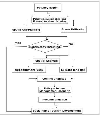
4.1Frame work
The government policy on sustainable coastal management for tourism planning
and development can be carried out through the implementation of integrated
management of land coastal ecosystem. Sustainable coastal zone management related
closely to three factor, i.e.: environmental ecology, economic and social factor which
are inter related and is regulated through laws and tradition. Problem occurred when
the relationship between the threes factors was not in harmonic order.
Space utilization based on sector’s interest and not considering the regulation
will be potential as the problem, which is usually arises from a discrepancy between
the present state and the desire state. In this case stakeholders often tried to utilize the
land coastal resources as much as possible, in accordance with their own interest. The
nature condition such as the availability of land, supporting capacity and environment,
social condition of local community had to be considered in the formulation of policy
on spatial use of coastal land.
Inconsistency in space utilization from the use plan is a potential social conflict
in space utilization. Studying the conflict is carried out through spatial analysis and
conflict analysis approaches. The spatial analysis is conducted using geographic
information system (GIS) in evaluating the situation to obtain tourism suitability,
existing land use, sand dune formation. Multi criteria analysis was used for conflict
solving analysis to obtain the best alternative land use. According to the results of
ordinal ranking of alternative land uses, the recommendation can be derived for
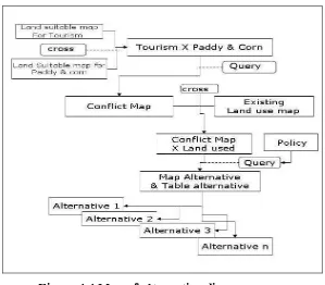
decision making. The diagram of research framework is shown in Figure 3.1. It should
sustainable policy.
Potency Region
Space Ut ilizat ion Spatial Use Planning
Policy on sust ainable land Coast al t ourism planning
Spat ial Analysis
Suitabilit y Analyses Exist ing land use
Conflict analyses
Policy scheme/ Management scenario
Sustainable Tourism Development Recommendat ion
No y es
[image:50.595.147.489.108.503.2]Consistency/ matching
Figure 4.1 Diagram of research framework.
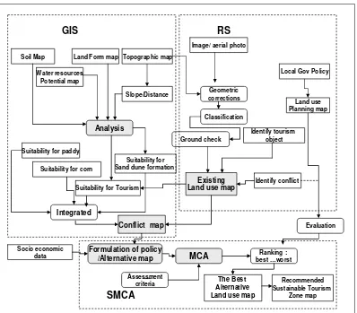
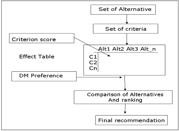
4.2Research steps
The diagram in Figure 3.2 shows the research procedures. Remote sensing
technology i.e.: aerial photograph and quick bird image were used to define existing
land use map. Geographic information system especially the spatial analysis function
was used for land suitability analysis, conflict analysis and to create the alternative
analysis to obtain the best alternative land use.
Topographic map Soil Map
Slope/Distance Land Form map
Local Gov Policy Image/ aerial photo
Suitability for Tourism Suitability for paddy
Suitability for corn
Land use Planning map Identify conflict Identify tourism object Existing Land use map
Socio economic data
Conflict map
Recommended Sustainable Tourism Zone map GIS RS SMCA Ground check Analysis Integrated Classification Geometric corrections MCA Formulation of policy
/Alternative map Assessment criteria Ranking : best …worst Evaluation Suitability for
Sand dune formation Water resources
Potential map
[image:51.595.119.517.108.457.2]The Best Alternative Land use map
Figure 4.2 Research Steps.
4.2.1Existing Land-use map
Identification of the existing land use of Parangtritis Village was done by visual
interpretation of aerial photograph 2000 and quick bird imagery 2003. The area can be
classified in to tree main group, namely vegetation, non vegetation and open land. The
vegetation can be divided in to dense and less dense, then the type of vegetation
identified through situation in wet or dry land. Non vegetation can be settlement, road,
river. For acquiring better geometric imagery, the first step prior is to correct error of
geometric by using digital topographic map or ground control point .
ground control point (GCPs), which are selected transform the geometry of the aerial
photograph/image, than each pixel corresponds to a position in a real world coordinate
system.
Classification boundaries are determined by digitizing on screen using Arc
View. Aerial photographs and satellite images can be classified to identify settlement,
forest cover, bare land etc to produce existing land-use map. Figure 4.3 shows the
diagram of land use mapping.
Figure 4.3 Land use mapping diagram. 4.2.2Ground checking
Ground checking is used to compare between the object samples in the image
with the real surface of earth, to ensure the accurate of interpretation result. During
this activity questionnaire were distributed to acquire additional information of the
land used and tourist object, and collecting needed data from related institution. The
village monographic and land use planning are collected from Baparda and Bappeda
Bantul. Aerial photographs and the previous researches are collected from Gadjah
4.2.3Land Suitability Analysis
Land suitability assessment is concerned with ‘the process of estimating the
potential of land for alternative kinds of land use’ (Dent and Young, 1981). Land use
could be in the contexts of agriculture, engineering, forestry, or recreation; but
agriculture may be the most popular area where land suitability assessment is applied.
In the agricultural context, the evaluation is directed to a specific kind of land
utilization (FAO, 1976), at specified units of homogeneous delineation.
Land suitability in the research area including land suitability for paddy field,
corn and tourism area. The steps of geographic information system analysis are: (1)
preparing metric of suitability for paddy field, dry culture and tourism (2) scoring and
weighting (3) spatial analysis to obtain suitable area for paddy field, corn and tourism.
Land suitability matrix that is used for tourism is based on criteria developed by
Bakosurtanal and matrix that is used for dry culture, paddy field, is based on criteria
developed by Puslitanak. Table 3.1, Table 3.2, and Table 3.3 show the matrices of
criteria of land suitability.
Table 4.1 Matrix for suitability of land coastal tourism activities Categorize and scoring
Variable Wei ghti
ng Highly suitable S1
Score Suitable S2 Score Marginally Suitable S3
Score Not suitable N
Score
Type of beach
8 Fine sand 9 Sand small
coral
7 Sand coral
Small steep 5 Mud, mangrove Coral, very steep 3 water resources potential
8 High 9 Medium 7 Low 5 Scarce 3
Land cover of beach
6 Coconut Open land
8 Brush small
grass savanna
6 High grass 4 Forest,
mangrove settlement
2
Distance from coastal line
6 < 500 8 500 - 1000 6 1000-1500 4 >1500 2
Table 4.2 Criteria land suitability for paddy field
Class Indicator Highly suitable
S1
Score Suitable S2
Score Marginally suitable S3
Score Not suitable N
Score
Temperature 24- 29 4 22 – 24 29 - 32
3 < 18
> 35
2 < 18
> 35
1
Water availability 33 - 90 4 30 - 33 3 2 1
Rot zone
Drainage Texture
Coarse material (%) soil depth (cm)
refined – <3 >50
4
Medium 3 – 15 40 - 50
3 Coarse 35 < 25 2 Coarse 35 < 25 1
Substrate retention (nr)
KTK (cmol) Basalt saturated (%) PH H2O C-Organic >16 > 50 5,5–8,2 4 <= 16 35 – 50 4,5– 5,5 8,2– 8,5
3 2 1
Toxicity (xc)
Salinity (dS/m) <2
4 2 - 4
3 > 6
2 > 6
1
Sodastic (xn)
Alkalinity /ESP (%) < 20
4 20 - 30
3 > 40
2 > 40
1
Sulfides risk (xs) Depth sulfides > 100 4 75- 100 3 < 40 2 < 40 1