STATEMENT
Hereby I, Jimmy Abdel Kadar, does declare that this thesis entitled “Suitability Analysis for Determining Potential Seaweed and Pearl Oyster Cultivation (A Case Study in Saleh Gulf)” is my own work and has not been submitted in any form for another degree or diploma programs (course) to any university or other institution. The content of the thesis has been examined by the advising committee and the external examiner.
Bogor, February 2010
ABSTRACT
JIMMY ABDEL KADAR. Suitability Analysis for Determining Potential Seaweed and Pearl Oyster Cultivation (A Case Study in Saleh Gulf). Under the supervision of KUDANG BORO SEMINAR and GATOT HARYO PRAMONO.
In recent years, particular geographic information systems can utilize area for spatial reasoning. Marine suitability analysis is a prerequisite for sustainable seaweed and pearl oyster cultivation production and it involves evaluation of the parameter such as depth, brightness, salinity, pH, dissolve oxygen, and temperature as infrastructure.
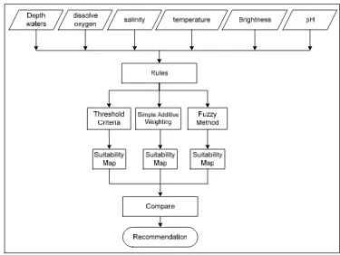
In approach of multi criteria decision making, the objective of this research is to analyze the marine suitability using minimum threshold criteria, simple additive weighting (SAW), and fuzzy logic. The parameters in these methodologies will be interpolated and reclassified as a set rule for the coastal marine suitability for seaweed and pearl oyster cultivation. The method of minimum threshold criteria implements matching of two different classes and results the lower class. The second method is using simple additive weighting that implements multiplication of score and weight on marine criteria. The third method is using a fuzzy decision analysis.
The comparative analysis of the three methods for seaweed majority indicates that classification of marine coastal suitability belongs to N class based on minimum threshold criteria. SAW method indicates produces two classes such as N and S3 class, while fuzzy method produces three classes: S1, S2, and S3. In SAW and fuzzy method indicates S3 class is higher than N class. The three methods for pearl oyster cultivation shows that the suitable marine using threshold criteria method which produce N classification. The suitable marine using simple additive weighting method produce two classifications: N and S3. S3 classification replies the biggest area than N classification. The suitable marine using fuzzy method produces three classifications: S3, S2 and S1 class, which describes that S1 class is larger than the other class in this location, and suitable for pearl oyster cultivation.
SUMMARY
JIMMY ABDEL KADAR. Suitability Analysis for Determining Potential Seaweed and Pearl Oyster Cultivation (A Case Study in Saleh Gulf). Under the supervision of KUDANG BORO SEMINAR and GATOT HARYO PRAMONO.
As an archipelagic state, Indonesia is one of the biggest areas in the world. The seaboard of Indonesia has a unique ecosystem of coral reef, seaweed and fish around coral. Therefore, coastal area has a unique problem to solve. This study emphasizes on coastal marine, spatial analysis of the coastal area using available data, in such a way that it can be used for recommendation output for cultivation coastal marine; seaweed and pearl oyster cultivation.
Coastal waters of coastal biological resources are potentials. This research emphasizes on analyzing the marine suitability of coastal area using minimum threshold criteria, simple additive weighting (SAW), and fuzzy logic for coastal marine suitability using multi-aspect technique for the purpose of decision making.
This matrix is based on the study of library and information specialists who are experts in the field. Individual fitness levels are divided into four classes, namely classes S1, S2, S3, and N. S1 class (very appropriate) is a region that does not have any constraint for a particular sustainable use; S2 class (according to) is a region that has little restraint for a particular use. This constraint will affect productivity and profits earned; S3 class (according to parole) is a region with a constraint which has a higher weight, but can still be improved by using high technology treatment; N class (not suitable with parole) is a region with very heavy constraint so it will be not possible to be used a particular sustainably.
In threshold criteria method each physical coastal marine waters is sequentially arranged in accordance to the parameters: depth, salinity, temperature, brightness, dissolve oxygen, and pH. These parameters were used as limiting factors for minimum threshold criteria. This method will compare the marine suitability with other physical parameters. This comparison is part of matching process. The Threshold criterion is expressed by the lowercase symbols after the symbol class.
The fuzzy logic is in general essentially a logic that allows values between 0 – 1 that will be assigned conventional evaluation, such as yes or no, right or wrong, etc. In generally, fuzzy method gives alternative way to handle situations and defined by membership degrees.
The comparison of three methods for seaweed describes that majority classification of coastal marine suitability belong to N based on threshold criteria. SAW method describes that produces two classes: N and S3, while in fuzzy method produces three classes: S1, S2, and S3. In SAW and fuzzy method describes that S3 is higher than N. The three methods for pearl oyster cultivation, shows that the suitable marine using threshold criteria method which produce N classification. The suitable marine using SAW method produce two classifications: N and S3. S3 classification replies the biggest area than N. The suitable marine using fuzzy method produces three classifications: S3, S2 and S1 class, which describes that S1 covers more areas than the other class in this location that is suitable for pearl oyster cultivation.
The comparison of three methods for seaweed cultivation, SAW method shows that the majority area of the classification belong to S3 (79.3 %) is the biggest area compare to N (20.7%) and fuzzy methods describe the majority area belong to S3 (94.5 %), S2 (0.4 %), and S1 (5.1 %) where threshold criteria method produces 100% of N class. The spatial polygon for pearl oyster cultivation using threshold criteria method belong to N classification (100%), but the result using SAW and fuzzy method is different. Both methods showed that pearl oyster has a big potential to be cultivated in this location. The use of SAW method for pearl oyster cultivated produced 90.4 % for S3 class. The use fuzzy method produced 33.6 % for S3 class, 4.9 % for S2 class and 61.5 % for S1 class.
There are 30 points of observation for seaweed cultivation. Validity for all this point of observations in minimum threshold criteria method is 100 % belongs to N. In SAW method, 88.3 % points of observation belong to S3 class and 16.7 % belong to N class. In fuzzy method, 10 % points of observation belong to S1 and 90 % belong to S3. For pearl oyster cultivation, there are 9 points of observation. In threshold criteria, 100 % points of observation belong to N class. In SAW and fuzzy methods, all points of observation belong to suitable order, therefore in SAW method 88.9 % belong to S3 class and 11.1 % belong to N. In fuzzy method, 44.6 % points of observation belong to S1 class and 55.6 % belong to S2 class.
Copy right ® 2010, Bogor Agricultural University
Copy right are protected by law,
1. It is prohibited to cite all or part of this thesis without referring to and mentioning the source
a. Citation only permitted for the sake of education, research, scientific writing, report writing, critical writing or reviewing scientific problem.
b. Citation does not inflict the name and honor of Bogor Agricultural University.
2. It is prohibited to republish and reproduce all part of this thesis without the written permission from Bogor Agricultural University.
SUITABILITY ANALYSIS FOR DETERMINING POTENTIAL
SEAWEED AND PEARL OYSTER CULTIVATION
(A CASE STUDY IN SALEH GULF)
JIMMY ABDEL KADAR
A Thesis submitted for the degree of Master of Science of Bogor Agricultural University
GRADUATE SCHOOL
Research Title : Suitability Analysis for Determining Potential Seaweed and Pearl Oyster Cultivation (A Case Study in Saleh Gulf)
Name : Jimmy Abdel Kadar Student Id : G051070031
Study Program : Master of Science in Information Technology for Natural Resources Management
Approved by, Advisory Board
Prof.Dr.Ir. Kudang B. Seminar, M.Sc Dr. Gatot H. Pramono Supervisor Co-Supervisor
Endorsed by,
Program Coordinator Dean of the Graduate School
Dr. Ir. Hartrisari Hardjomidjojo, DEA Prof. Dr. Ir. Khairil A. Notodiputro, MS
ACKNOWLEDGEMENT
I would like to express my gratefulness to The Almighty Allah who always gives His endless Grace and Blessing on me. I wish to thank to my supervisor Prof. Dr. Ir. Kudang Boro Seminar, M.Sc and my co-supervisor Dr. Gatot H. Pramono for the guidance, advices, comments, encouragement and also criticism during the supervision of my research. I would like to thank to Dr. Antonius B. Wijanarto as external examiner for his positive ideas, inputs and critics and also thank to Dr. Ir. Hartrisari Hardjomidjojo, DEA as Program Coordinator and all my lectures for having shared their knowledge and experiences.
I would like to thank to SEAMEO-BIOTROP management and staff. Thanks also to The MIT management and staffs as well as IPB post graduate for supported our administration, technical aspects and the facilities I would like to thank to all the member of lecturers who taught me the very importance knowledge for my future. Special thanks to all of MIT students especially class 2007, with our support each other, share laughs and pressures during my study and solidarities.
I deeply wish to express my most gratefulness to my beloved wife, Yane Sri Herliany for her support and patience during the study and for my son as love and support. And finally never enough thanks to one who doesn't want to be named but he knows who he is and so do I.
t I S A w C technology Indonesian Science in I Agricultural was on “Sui Cultivation ( Jim In un Fa 20 in Researc Institute of Information l University, itability Ana (A Case Stu
CURRIC
mmy Abdel ndonesia on
ndergraduate aculty Math 002 to prese ch Center f Sciences.
Technology in 2007 and alysis for De dy in Saleh G
CULUM V
l Kadar wa n March e diploma hematics and
ent, he has b Quality Sy He continue y for Natura d complete h etermining P
Gulf)”.
VITAE
as born in 26, 1972 from Pad d Natural S
been workin ystem and
ed his grad al Resource his master stu Potential Sea
Bandung, W . He rec djadjaran U cience in 1 ng as staff in
Testing T duate study
s Managem udy in 2010 aweed and Pe
TABLE OF CONTENTS
STATEMENT ... i
ABSTRACT ... ii
SUMMARY ... iii
COPY RIGHT ... iii
ACKNOWLEDGEMENT ... viii
CURRICULUM VITAE ... ix
TABLE OF CONTENTS ... x
LIST OF TABLE ... xii
LIST OF FIGURE ... xiii
I. Introduction ... 1
1.1 Background ... 1
1.2 Research Objective ... 2
1.3 Scope of Research ... 3
II. Literature Review ... 4
2.1 Definition and Characteristic ... 4
2.1.1. Characteristic of Coastal Marine ... 5
2.1.1.1 Brightness ... 5
2.1.1.2 Dissolved Oxygen ... 6
2.1.1.3 Temperature ... 6
2.1.1.4 Acidity ... 7
2.1.1.5 Salinity ... 7
2.1.1.6 Depth of Sea Water ... 8
2.2 Interpolation of Surface Analysis ... 8
2.3 Minimum Threshold Criteria for Marine Coastal Suitability ... 9
2.4 Simple Additive Weighting (SAW) for Marine Coastal Suitability ... 11
2.5 Fuzzy Method for Marine Coastal Suitability ... 12
2.6 Study Area ... 15
2.7 Seaweed Cultivation ... 17
2.8 Pearl Oyster Cultivation ... 17
III. Methodology ... 18
3.1 Multi-Aspect of Marine Characteristics ... 19
3.2 Marine Suitability using Simple Additive Weighting and Minimum Threshold Criteria Method ... 19
3.2.1 Minimum Threshold Criteria for Marine Suitability ... 21
3.3 Fuzzy Method Approach in Marine coastal Suitability ... 23
3.4 Data Sources ... 26
IV. Results and Discussions ... 27
4.1 The Constraints of the Research ... 27
4.2 Marine Coastal Suitability using Minimum Threshold Criteria ... 27
4.3 Marine Coastal Suitability using Simple Additive Weighting Method ... 30
4.4 Marine Coastal Suitability using Fuzzy Method ... 32
4.5. Comparative Evaluation ... 37
4.5.1 Seaweed Cultivation ... 37
4.5.2 Pearl Oyster Cultivation ... 39
4.5.3 Comparative Three Methods ... 41
V. Conclusion and Recommendation ... 43
5.1 Conclusion ... 43
5.2. Recommendation ... 44
References: ... 45
Appendix 1 ... 47
Appendix 2 ... 50
Appendix 3 ... 52
LIST OF TABLES
Table 2-1. Marine coastal suitability for seaweed cultivation ... 4
Table 2-2. Marine coastal suitability for pearl oyster cultivation ... 5
Table 2-3. Range marine suitability class for SAW method ... 12
Table 2-4. Land suitability index use as fuzzy logic method ... 15
Table 2-5. Range marine suitability index use as fuzzy method... 24
Table 2-6. Data distribution for point of sample ... 26
Table 2-7. Data Distribution for point of observation... 26
Table 4-1. Example fragment of Minimum Threshold Criteria ... 28
Table 4-2. Evaluation criteria of fuzzy set model and membership functions (MF) parameter for seaweed cultivation ... 33
Table 4-3. Evaluation criteria of fuzzy set model and membership functions (MF) parameter for pearl oyster cultivation ... 34
Table 4-4. Point of research of seaweed observations in the field ... 38
Table 4-5. Point of research of pearl oyster observations in the field ... 40
Table 4-6. The comparative three methods for seaweed and pearl oyster cultivation ... 41
Table 4-7. Percentage of observation point in the suitability area ... 42
LIST OF FIGURES
Figure 2-1. Structure of the suitability classification ... 10
Figure 2-2. Fuzzy set models used for rating land attributes ... 14
Figure 2-3. Location of study area ... 16
Figure 3-1. Framework of research ... 18
Figure 3-2. Analysis marine suitable with simple additive weighting and minimum threshold criteria ... 19
Figure 3-3. Process for minimum threshold criteria and simple additive weighting ... 21
Figure 3-4. Classification of marine suitability using simple additive weighting 22 Figure 3-5. Analysis marine coastal suitable with fuzzy method ... 24
Figure 3-6. Process for fuzzy set method ... 25
Figure 4-1. Marine coastal suitability using minimum threshold criteria ... 29
Figure 4-2. Marine coastal suitability for using simple additive weighting method ... 31
Figure 4-3 SAW method spatial interpolation of seaweed cultivation with point of sample ... 32
Figure 4-4. Fuzzy membership functions of each physical parameter for accessing marine coastal suitability for seaweed cultivation ... 33
Figure 4-5. Fuzzy membership functions of each physical parameter to access marine coastal suitability for pearl oyster cultivation ... 34
Figure 4-6. Marine coastal suitability using fuzzy method ... 35
Figure 4-7 Fuzzy method spatial interpolation of seaweed cultivation with sample point ... 36
Figure 4-8. The comparative of area for three method for seaweed cultivation ... 39
I. INTRODUCTION
1.1 Background
As an archipelagic state, Indonesia is one of the biggest areas in the world. The seaboard of Indonesia has a unique ecosystem of coral reef, seaweed and fish around coral. Therefore, the coastal area has a unique problem to be solved.
This study emphasizes on coastal marine, spatial analysis of the coastal area used available data, in such a way that can get recommendation output for coastal marine cultivation. The development of the coastal marine considered custom of local population which could assist the local government in preparing the development planning. It also provides an alternative source of information that can be used for all needs such as for the development of industrial sector, economic, and human resources.
Generally, spatial decision making means “closed” process with limited parameter input to get a better output (Malczewski, 1999). These days some spatial decisions have been made by people as planners who work for the government with less real specification, while it claimed that decision-making reflected public needs and also claimed as public opinion. The last decade with the rapid change of environment planning also change spatial decision-making with more demands and needs. Recently, environment development for spatial decision-making involves public collaboration and participation to get more effective solutions to spatial decision-making problems.
Synergy of GIS and MCDA is used to dealing with spatial planning. And the process can mean that the transformation process on the map that will be assessed and combined with the assessment of the decision maker to produce accurate information (Malczewski, 2006). The implements of GIS-MCDA also used the assessment of a specialist reference group expert that has been identified as a basic reference. The GIS-MCDA system could solve the potential problem with the approach of communication in building communication with stakeholders. In addition, tools to the implementation to solve an occurring issue are also used.
The overall system that will be developed assembles information on the importance of many variables of coastal marine. Other advantages used MCDA as management data so that it could expect output information, and update easily. This information is useful for the local community who lives in and around the coastal area to be involved in coastal development and conservation and to understand the environmental problems of coastal marine. Thus, special problems could be identified, compared with coastal marine globally to show which coastal areas may share common problems and the possibility to cooperate in solving those problems.
Saleh gulf, as one of the coastal area in Sumbawa Island, has also a threat such as exploitation that can lead to environmental and natural resources degradation of the coastal area if not managed properly. The coastal zone has a coastline length of 79.6 kilometers, and the total area is about 20 153.15 km2. The facts in Sumbawa coastal region appeal to development of various activities.
1.2 Research Objective
1.3 Scope of Research
• Study area will be chosen in Saleh gulf in Sumbawa Island.
• The potential cultivation zone is determined for analysis seaweed and pearl oyster cultivation. The methods applied in this research are minimum threshold criteria, simple additive weighting (SAW) and fuzzy method for marine coastal suitability.
II. LITERATURE REVIEW
2.1 Definition and Characteristic
Coastal waters of coastal biological resources coastal waters are potential enough to be developed. This research emphasized on marine coastal suitability analysis for coastal aquatic seaweed and pearl oyster cultivation. Common products of the coastal marine are much as food or as an additive for the food industry, pharmaceuticals, cosmetics, and others. In addition, it could be also utilized as green marine as well as cattle and fish feed components.
Table 2-1. Marine coastal suitability for seaweed cultivation (source: Suryanto et. all, 2006)
Parameter S1 [80] S2 [60] S3 [40] N [1] Open water depth (m)
[35]
1 - 5 < 1
> 5 Dissolved oxygen (mg/l)
[10]
> 6 > 5 – 6 4 – 5 < 4
Salinity (ppt) [10]
28 - 36 > 20 – 28 12 – 20 < 12 > 36 Temperature (oC)
[10]
26 - 31 24 - < 26 > 31 – 33
20 - < 24 > 33 – 35
< 20 > 35 Brightness (%)
[25]
> 75 50 – 75 25 – 50 < 25
pH [10]
7.5 – 8.3 7 – 7.5 > 8.3 – 8.5
6.5 - < 7 > 8.5 – 9
< 6.5 > 9
Table 2-1 and table 2-2 are matrices based on the study of library and information specialists who are experts in the field (Wiradisastra, 2004). Individual fitness levels are divided into four classes, namely classes S1, S2, S3, and N.
• S1 class (most suitable) is a region that does not have any constraint for a particular sustainable use;
• S2 class (suitable) is a region that has little restraint for a particular use. This constraint will affect productivity and profits earned from the marine coastal; • S3 class (less suitable) is a region with a constraint which has a higher weight,
• N class (not suitable) is a region with very heavy constraint so it will be not possible to be used a particular sustainably.
Therefore the classification will be built based on criteria and data shown in table 2-1 and table 2-2.
Table 2-2. Marine coastal suitability for pearl oyster cultivation (source: Suryanto et. all, 2006)
Parameter S1 [80] S2 [60] S3 [40] N [1] Open water depth (m)
[50]
1 - 11 > 11 – 28 28 – 36 16 – 20
< 1 > 36 Dissolved oxygen (mg/l)
[10]
> 6 > 5 – 6 4 – 5 < 4
Salinity (ppt) [10]
27 – 34 > 24 – 27 > 34 – 38
20 – 24 > 38 – 40
< 20 > 40 Temperature (oC)
[10]
26 – 29 23 - < 26 > 29 - 31
20 - < 23 > 31 – 34
> 34 < 20 Brightness (%)
[10]
> 80 70 – 80 60 – 70 < 60
pH [10]
7.7 – 8.3 7.7 – < 7.7 > 8.3 – 8.5
7 - < 7.5 > 8.5 – 9
> 9 < 7
2.1.1. Characteristic of Coastal Marine
The characteristics of the location to be studied can be expressed into several parameters. Each commodity has a value and certain bio-physical measurement requirements that should be fulfilled for a particular commodity.
2.1.1.1 Brightness
the brightness can reach the bottom water, which indicates that the water condition is very good to be used for the development of marine cultivation. Production of seaweed and pearl oyster increases in the dry season, and will become less in rainy season.
2.1.1.2 Dissolved Oxygen
Dissolved oxygen (DO) is derived from the results of a photosynthesis process of water plant or diffusion of oxygen into water by aeration (rapid movement) as a waste product of photosynthesis. Photosynthesis processes could occur in green plants and some chlorophyll-containing bacteria (Utama, 2005). Oxygen is needed by all sentient life in the water such as fish, shrimp, shellfish and other animals, including microorganisms such as bacteria. DO is the most important indicator of the health of a water body and its capacity to support a balanced aquatic ecosystem of plants and animals. Waste water containing organic (oxygen consuming) pollutants depletes the dissolved oxygen and may lead to the death of marine organisms. DO content in water provides a high level guidance to the primary productivity of water. Oxygen molecules are contained in the physics of soluble water. Hence, solubility is strongly influenced by water temperature. DO from the field measurements indicated highest from 2.6 - 4.7 mg / I for seaweed and pearl oyster. In overall the observed water is suitable enough to support aquatic life organisms (Wiradisastra, 2004).
2.1.1.3 Temperature
subtropical regions (Utama, 2005). This is because much cloudy cover in many tropical areas compared with sub tropic. Temperature changes slowly from the coast towards offshore, temperature generally is higher in coastal areas because the sea could absorb sunlight easier while for the sea it is not easy to change the temperature when the environmental temperature does not change, commonly the temperature of the offshore is stable. Temperature is one of the most important factor for living organisms in the ocean, because temperature affects both metabolism and proliferation activity of any organism. Average temperature between each measurement point does not differ significantly, which range from 21oC – 32oC for seaweed and 21oC – 32oC for pearl oyster, where the temperature was within the category is suitable for developing marine farming area. The range of temperature is not large due to Indonesian waters have a uniform temperature pattern (Wiradisastra, 2004).
2.1.1.4 Acidity
Acidity or Potential of Hydrogen (pH) measured concentration hydrogen ion in water, indicated the acid and alkalie degree of sea water. Generally, acidity scale is from 0 to 14, the mean value is a neutral number 7. Measurement of acidity is very important because acidity values affect the solubility and availability of various nutrition for the organism. Sea water has ability to sustain fluctuating changes in acidity. pH or water acidity is one of the factors affecting productivity. pH is measured during the study which ranged from 7.2 - 7.9 ppm for seaweed and 7.2 – 7.9 ppm for pearl oyster. The pH ranges show that the open water is productive. Changes in pH can have bad consequences for the life of sea biota, either directly or indirectly (Wiradisastra, 2004).
2.1.1.5 Salinity
pressure; the more the higher salinity the more higher the osmotic pressure, another cases influence by tidal and seasonal. Salinity around the estuary tends to decrease, but during the dry season when the flow of the river water decrease, sea water flow further to around estuary so that the increased salinity in estuary. In contraraly in the wet season, there is an increase flow freshwater from rivers which empty into the sea, so salinity in the estuary decrease. Salinity is very influential on the cultivation of seaweed and other organisms, because each organism has a certain range for life. Salinity measured during the study ranged from 33 - 34 ppt for seaweed and 33 – 34 ppt for pearl oyster. Many environmental factors affected the changes in the salinity such as: water circulation, evaporation, precipitation and flow of the river to the estuary (Wiradisastra, 2004).
2.1.1.6 Depth of Sea Water
Depth of sea water is one of the most important parameter in studying the dynamics of the sea. Slight differences in the depth (for example due to differences in surface heating) will result to differences in ocean currents. Therefore, the determination of depth is important in oceanography. Water pressure increases according to the depth of the sea. Depth of sea water is usually measured by using the echo sounder or CTD (conductivity, temperature, depth). The depth is measured using CTD based on the value of pressure. Depth Measurements are made at selected points to represent the whole mapped area. The information about the components of this data is obtained from field, the lowest is about 1.4 meter and the highest depth is 85 meter. Reference data which have been collected and processed from various maps are then overlaid and spatial interpolation technique (Wiradisastra, 2004).
2.2 Interpolation of Surface Analysis
use creating surface or called interpolators, create a continuous surface from sample input point values, and using spline method as interpolators to build a location for placing result of overlay. Spline method is general purpose interpolation that fits in a minimum curvature surface through the input points. This method is best use for gently varying surface such as elevation.
Interpolation is used to estimate the value of a function between known data points without knowing the actual function. Interpolation methods can be divided into two main categories:
• Global interpolation. These methods rely on a constructing single equation that fits all the data points. This equation is usually a high degree polynomial equation. Although these methods result in smooth curves, they are usually not well suited for engineering applications, as they are prone to severe oscillation and overshoot at intermediate points.
• Piecewise interpolation. These methods rely on constructing a polynomial of low degree between each pair of known data points. If a first degree polynomial is used, it is called linear interpolation. For second and third degree polynomials, it is called quadratic and cubic splines respectively. The higher the degree of the spline, the smoother the curve. Splines of degree m, will have continuous derivatives up to degree m-1 at the data points.
(Kruger, 2008)
2.3 Minimum Threshold Criteria for Marine Coastal Suitability
Marine coastal suitability classification is a process and regrouping of marine characteristics in terms of the relative marine suitability or coastal with certain purpose. Marine coastal suitability class is determined by the highest limiting factor or the minimum threshold criteria in physical marine characteristics.
Physical parameters: depth, salinity, temperature, brightness, dissolve oxygen, and pH will be developed for a specific use, so in this report the use of minimum threshold criteria to calculation limiting marine coastal suitability.
Marine coastal suitability classification involves the compared marine suitability with other physical parameters. This comparison is part of matching process. Threshold criteria is expression by the lowercase symbols after the symbol class, example S2s means marine coastal suitability S2 class which threshold criteria physical parameter is s (Figure 2-1).
Figure 2-1. Structure of the suitability classification (modify base on, FAO 1976)
Figure 2-1, shows there are three column: order, class and subclass. ‘Order’ presents the possible values of marine coastal condition possibilities, which are (1) Suitable (S) or (2) not suitable (NS). The suitable marine coastal can be further categorized as class whose values can be either S1, S2, or S3 where the values Si
Sj, i j indicate that marine coastal with value Si is better than Sj. The suitable
marine coastal subclasses reflect kinds of limitations. Subclass is expressed with the lower case symbol as limiting factor, in this example m and/or e are used as parameter. There are two guidelines for subclass:
• As few limitations as possible should be used in the symbol for any subclass. One, rarely two, letters should normally suffice. The dominant symbol (i.e. that which determines the class) should be used alone if possible. If two limitations are equally severe, both may be given. (FAO, 1976)
2.4 Simple Additive Weighting (SAW) for Marine Coastal Suitability
SAW stands for simple weight and probably the best known in many weighting and very widely used in multiple attribute decision making. Basic concept of this method is to search for average weight in of all alternative attributes; the decision maker assigns determines the weights based on their importance of each attribute. Another opinion when the decision maker can obtain a total score for each alternative by multiplying the scale rating for each attribute influenced by the weights based on their importance then summing with all the attributes. Simple Additive Weighting method can be stated as follows:
Ai = ∑ ……… ………..…… (1)
Where xij is the score of the ith alternative with respect to the jth attribute, wj is the
normalized weight. The GIS-based SAW method involves the following steps (Malczewski, 1999):
• Define the set of evaluation criteria (map layer) and the set of feasible alternatives attributes
• Standardize each criterion weight map layer
• Define the criterion weight; that is, a weight of “relative importance” is directly assigned to each criterion map
• Construct the weighted standardized map layer • Generate the overall score for each alternatives
• Rank the alternatives according to the overall performance score
in range of 40 – 60, and N class where the values are less than 40, as describe in table 2-3.
Table 2-3. Range marine suitability class for SAW method (Wiradisastra, 2004)
LSI Symbol Suitability Class
100 – 80 S1 Most suitable
79,99 – 60 S2 Suitable
59,99 – 40 S3 Less suitable
> 40 N Not suitable
2.5 Fuzzy Method for Marine Coastal Suitability
The fuzzy logic in general is essentially a logic that allows values between 0 – 1 that will be assigned conventional evaluation, such as yes or no, right or wrong, etc. which could be formulated mathematically. Fuzzy logic can be used to model and deal with the appropriate information, such as incorrect measurements or expert knowledge available in the form of verbal description.
The digital computing world is built on the structure of boolean logic (0 and 1) and applied to the value of discrete such as one or zero, yes or no, etc. But this is a big idea structure and need simplification in the real world, where many of the problems that have a description as gray between black and white (Baja, 2002). Fuzzy logic in multi-theory which the value of values as "moderate," "high", "low" on the application in the real world is used as a yes or no, right or wrong is also used in the conventional theory crisp. In daily life, the allegation metric is use clearly related to the concept or the numeric value. In generally, fuzzy method gives alternative way to handle situations and defined by membership degrees.
variables are those that facilitate the gradual transition between the state and, therefore, have a natural expression and the ability to deal with observation and measurement of fuzziness. Fuzzy logic is a superset of classical logic with the introduction of "degree of membership." These degrees of membership are possible to interpolate input between crisp set. The operator logic is quite similar, except their interpretation differs.
Model functions used to calculate membership function (MF) of marine coastal attributes are depicted in Figure 2-2 (adapted from Burrough and McDonnell, 1998). Model 1 in figure 2-2 is used to determine the membership grades of marine coastal qualities with symmetric functions, where only one ideal point or central concept exists. Another type of symmetric function is shown in model 2 of figure 2-2, where the central concept consists of a range of values (from b1 to b2). Further more, there are also situations where only the lower and upper boundary of a class has practical importance (Burrough and McDonnell, 1998).
In such circumstances, an asymmetric function needs to be applied (models 3 and 4 of figure 2-2). An asymmetric left function is used for the lower boundary of a class, while an asymmetric right is employed for an upper boundary. If MF(xi)
represents individual membership value for ith marine coastal property x, then in the computation process these model functions (Models 1 to 4) take the following form (Burrough and McDonnell, 1998):
MF(xi) =
…
………..….… (2)For optimum range (Model 2):
MF(xi) =
1,
For asymmetric left (Model 3):
MF(xi) =
1,
... (4)
For asymmetric right (Model 4):
MF(xi) =
1,
……….. (5)
Where MF(xi) = membership function of marine coastal;
d = transition zone;
b = lower and upper crossover points.
Figure 2-2. Fuzzy set models used for rating land attributes (adapted from Burrough and McDonnell, 1998).
recreation, and arable farming. The conditions of the marine coastal necessary for successful and sustained implementation of the specified marine coastal type, namely marine coastal use requirements, were determined using related literature information and available data. The land suitability index (LSI) of the marine coastal mapping unit for each marine coastal type was calculated using the multiplicative combination of suitability rating index (FAO, 1976), and LSI value is expressed on a discrete scale of suitability classification for a specific in table 2-4.(Kilic, et al., 2003)
Table 2-4. Land suitability index use as fuzzy logic method
LSI Symbol Suitability Class
1,00 – 0,90 S1 Most suitable
0,89 – 0,75 S2 Suitable
0,74 – 0,50 S3 Less suitable
< 0,49 N Not suitable
The class criterion for marine coastal suitability evaluation using fuzzy method is describe in table 2-4 such as S1 class, S2 class, S3 class, and N class. These ordinal values are used in marine coastal suitability analysis, with scale of 0 to 1, therefore each class has a particular criteria to contribute to the goal.
2.6 Study Area
Sumbawa Island is located in West Nusa Tenggara province, Indonesia. The western part of this island is bordered by the Alas strait. This border separate with Lombok Island, the eastern part of this island is bordered by Sape strait, this border separate the island of Komodo, the Indian Ocean in the south, and the Flores Marine coastal to the north, and Bima is the largest city, located in the eastern part of the island.
is located between 8 ° 10 '- 9 ° 5' south latitude and 115 ° 46 '- 119 ° 5' east longitude.
Figure 2-3. Location of study area
Majority of the population around the bay are fishermen, aside from fishing most of the fishermen also conduct seaweed and pearl oyster cultivation as aside income. Seaweed and pearl oyster cultivations to play an important role in supporting regional economic development contributing to regional economic growth due to rising incomes of local communities.
2.7 Seaweed Cultivation
Development of seaweed cultivation is one of the alternatives of marine commodities cultivation. This activity becomes a foundation for the cultivation of marine food resources in the future. Based on marine coastal suitability utilization of coastal marine are as it is potential to increase the income. The location for seaweed cultivation needs specific environmental conditions.
Indonesia as an archipelagic state has a huge potential for the development of seaweed cultivation, especially in coastal marine areas and the gulf. This condition is possible become the seaweed habitat is suited to the waters condition because relatively low rainfall, and lack of fresh water from the estuary. Seaweed is one of the commodities with high demand and is used in various fields such as medicine, agriculture, pharmaceutical, and industry, and could also be processed into semi-finished materials. Seaweed cultivation is highly profitable increase the income of fishermen. The efforts of seaweed cultivation need to be assessed and explored as potential marine coastal suitability (Syahdan, 2008).
2.8 Pearl Oyster Cultivation
III. METHODOLOGY
Development of the main idea in designing basic pattern is preparing an information coastal marine suitability for Saleh gulf. Approach for this research is to implement a process which carry out several methods such as minimum threshold criteria, simple additive weighting and fuzzy logic to be introduced.
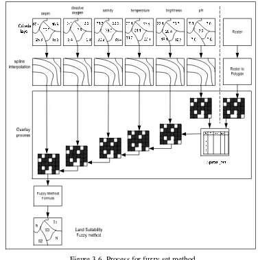
[image:31.612.129.504.187.469.2]
Figure 3-1. Framework of research
3.1 Multi-Aspect of Marine Characteristics
Multi-aspect of marine characteristic analysis consists of a set of systematic procedures which is developed to select the best alternative from a set of competing options. These procedures include dividing the decision problems into more smaller understandable parts; analyzing each part; and integrating the parts in a logical manner to produce a meaningful solution (Malczewski, 2006). Spatial multi-aspect analysis typically involves a set of geographically-defined alternatives, which require information on criterion values and alternative geographical locations. The results of decision analysis have evolved into a diverse range of decision techniques that can be applied in many different decision making methods.
3.2 Marine Suitability using Simple Additive Weighting and Minimum Threshold Criteria Method
[image:32.612.241.396.468.639.2]Based on table 2-1 for SAW and threshold criteria method, each physical parameter has a significant contribution to the growth of the commodities, and these physical parameters have been given index score and weighting based on experts opinion.
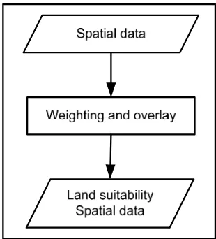
Figure 3-2 shows the general phase for SAW and threshold criteria. In the spatial data phase the physical parameters are collected such as depth, dissolved oxygen, salinity, temperature, brightness, and pH. In weighting and overlay phase, the process of each physical parameter data will be reclassified based on rules (table 2-1). And the result will be marine suitability spatial data phase based on the formation of each function area. The general process is described in figure 3-3.
The data are obtained from the field in the form of points of research (figure 3-3). Data processing required several stages to be converted to polygon maps. In the first phase (criteria layer), physical parameters have criteria data as put in criteria layer. In the second phase (spline interpolation), the criteria data is converted using spline interpolation, this process will generate several classification according to the data. Spline method is the interpolation method used to obtain the minimum value of the curve between the input values. The third phase (convert and edit field) is to classify the data that has been formed into several classes according to the physical parameters that have been set. In this phase the data to determine the value of marine suitability (S1, S2, S3, N). Criteria used are as follows; S1 Class (most suitable) using the number 1, S2 class (suitable) using the number 2, S3 Class (less suitable) using the number 3 and Class N (not suitable) using the number 99 (Pramono, 2004).
depth
dissolve
oxygen salinity temperature brightness pH
30.5 25.3 46.9 16.3 60.4 3.6 2.9 3.4 2.8 3.1 33.7 33.2 33.5 33.3 33.4 30.1 31.1 33.7 33.1 32.1 18.1 19.6 20.4 25.3 22.1 7.5 7.3 7.8 7.6
7.2 Criteria layer
Weighted Criteria layer
Land Suitability Map
spline interpolation
dfs et we qwdf
1 4
7
9
dfs et we qwdf
1 4
7
9
dfs et we qwdf
1 4
7
9
dfs et we qwdf
1 4
7
9
dfs et we qw df
1 4
7
9
dfs et we qwdf
1 4
7
9
[image:34.612.132.501.79.570.2]Convert and edit field N S2 S3 N S3 N S2 S3 N S3 N S2 S3 N S3 N S2 S3 N S3 N S2 S3 N S3 N S2 S3 N S3 Overlay process 1 60 40 80 60 Simple Additive Weighting Threshold Criteria Convert to polygon N S2 S3 N S3 N S2 N N S3 S3 N S2 S3 S3 Simple Additive Weighting Formula Minimum Threshold Criteria Formula
Figure 3-3. Process for minimum threshold criteria and simple additive weighting
3.2.1 Minimum Threshold Criteria for Marine Suitability
parameter is sequentially arranged in accordance to the marine evaluation that needs to be quantified. Physical parameter data i.e depth, salinity, temperature, brightness, dissolved oxygen, and pH will be developed criteria table for a specific use, hence this method used matching limiting factor of marine suitability.
Marine suitability classification involves matching of marine suitability with other physical parameters. The result of this match is signed as subclass of marine suitability is marked by a specific threshold criterion. The threshold criteria is expression by the lowercase symbols after the symbol class. Example, if suitability class S1 is matched with suitability class S2 then the result will be S2s. S2s means that S2 is the result suitable class and the lower case s is parameter as threshold criteria.
3.2.2 Simple Additive Weighting for Marine Suitability
[image:35.612.157.476.507.643.2]This method is based on the concept of a weighted average. The decision maker directly assigns weights of “relative importance” to each attribute. A total score is obtained for each alternative by multiplying the importance weight assigned for each attribute will be scaled value given to the alternative on attribute, and summing the products over all attributes. When the overall scores are calculated for all the alternatives, the alternative with the highest score is chosen.
A map represents some evaluation criteria such as S1, S2, S3, and N class. These ordinal values are used in marine suitability analysis, therefore the classes have to be rated, for example class S1 with respect to a particular criteria to contribute to the goal. This process is relatively important and called criteria standardization. Commonly evaluation of criteria standardization is described normally on the range of 0 to 1, or 0-10 or 0-100 etc. In certain evaluation of marine coastal suitability it can be represented by GIS layer and some non spatial data.
In describing levels of the criteria evaluation are required to the weights. In figure 3-3 the criteria weights need to be placed and summed, then the well-established geometric mean method is used. In this approach all the elements of weight will be multiplied with score until the nth. The calculation of these map are divided by their sum to get the normal weights. The hierarchy of the criteria is obtained. Standardized Criteria maps such as weights are multiplied with these scores at each level of the criteria.
Physical parameter data of depth, salinity, temperature, brightness, dissolve oxygen, and pH are given weighting and index score according to the characteristics of groups of marine coastal suitability data (table 2-1), then the data for weighting, index scoring and value of criteria will be multiplied, summed up and divided by maximum percentage in amount of thematic data. The formula used is as follows:
Scoring average = (weight of salinity + weight of depth + weight of brightness + weight of temperature + weight of dissolved oxygen + weight of pH) / 100………..(6) (Pramono, 2004)
3.3 Fuzzy Method Approach in Marine coastal Suitability
membership function (MF) of physical parameter are depicted in figure 2-1 (adapted from Burrough and McDonnel, 1998 ).
Figure 3-5. Analysis marine coastal suitable with fuzzy method
[image:37.612.160.479.522.622.2]Figure 3-5, the phase spatial data consist of collected data from the field. The phase weighting and overlay with fuzzy method is indicated by each physical parameter such as depth, salinity, temperature, brightness, etc., and will be converted into fuzzy number in the range 0 and 1. Equation member function of fuzzy method is used to calculate the process depend on input data from the field. The overall process of this method is presented in figure 3-6.
Table 2-5. Range marine suitability index use as fuzzy method (Modify)
LSI Symbol Suitability Class
1,00 – 0,80 S1 Most suitable
0,79 – 0,60 S2 Suitable
0,59 – 0,40 S3 Less suitable
< 0,39 N Not suitable
according to the data. The third phase (Overlay process), the same process with threshold criteria and SAW method, an overlay operation will join all features of attributes of spatial data from a region in map.
Figure 3-6. Process for fuzzy set method
3.4 Data Sources
[image:39.612.169.473.483.563.2]The data distribution for point of sample in this location has identified and delineated as marine coastal suitability. Mainly the data used for this research is acquired from Pramono (2009). This is done by identifying the parameters such as salinity, temperature, dissolved oxygen, brightness, depth and acidity from point of research that are measurements from field. This data consist as describe in table 2-6, and also for next process use as based on spatial interpolation.
Table 2-6 Data distribution for point of sample Number points of research 20 points of sample
Number of parameters 6 parameters
Date and time 10 -12/Nov/2008 and 1 pm - 5 pm Weather condition Cloudy
Marine condition Steady/wave
Data distribution for point of observation has identified for potential cultivation such as seaweed and pearl oyster. This data is produced from collecting data from field after calculation the spatial polygon map. The information of cultivation in this point of observation as showed in table 2-7. This data use for validation as number points of observation for seaweed and pearl oyster cultivation.
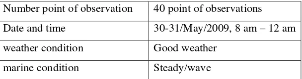
Table 2-7 Data Distribution for point of observation Number point of observation 40 point of observations
Date and time 30-31/May/2009, 8 am – 12 am weather condition Good weather
marine condition Steady/wave
IV. RESULTS AND DISCUSSIONS
Generally, analysis of marine coastal suitability is computing several physical parameters in a particular location, which comparison between the criteria of classification and rule requirements should be fulfilled for a particular commodity in order to obtain maximum production. These criteria of physical parameters are called “marine suitability” when maximum value of all physical parameter criteria is the highest value and also vice versa if the criteria of physical parameter conditions outside of the desired value with the desired sentence is indicated as "not suitable".
4.1 The Constraints of the Research
Before discussing results, there are some limitations of this works to be aware and the limitations as follows:
• Marine coastal suitability evaluation is based on bio-physical parameters. The process did not accommodate cultural and economic evaluations such as annual income of fishermen.
• The sample points in this study are considered not sufficient, so it could influence the process of spatial interpolation.
• This study did not consider the effect of seasonal change within a year, where in rainy season, seaweed and pearl oyster cultivation are much affected.
4.2 Marine Coastal Suitability using Minimum Threshold Criteria
Based on criteria is used in third phase in figure 3-3, then the fourth phase (convert to polygon) is converting raster into polygon. In this phase a fragment of database is converted into classification criteria. Data column of gridcode in fragment of database consist of 1, 2, 3, and 99 which will be corrected and convert into classification criteria as S1, S2, S3, N. The fifth phase (Overlay process) in figure 3-3, overlay has been done in 5 stages for 6 maps.
simple computer program. Type as number 4 represents S1, number 3 as S2, number 2 as S3 and number 1 as N. The matching process will generate the lowest classification of marine coastal suitability as described. For instance, a fragment process matching in table 4-2 used six physical parameters in the first row (temperature, salinity, pH, brightness, depth and dissolved oxygen) which have values as 4(S1), 4(S1), 2(S3), 1 (N), 1 (N), 2 (S3), then the result of this marine coastal suitability will be N as the lowest. The same process will be done for the second row and so on.
Limitations and completeness of data on the map need to be examined prior to be processed to prepare the expected data, because if the data is incomplete, the result from the initial process will be different and produce invalid marine coastal suitability.
Table 4-1. Example fragment of Minimum Threshold Criteria
Spatial Analysis for Seaweed and Pearl Oyster Cultivation
(a) Seaweed cultivation
[image:42.612.135.472.67.627.2](b) Pearl oyster cultivation
Figure 4-1. Marine coastal suitability using minimum threshold criteria
criteria layer. Seaweed and pearl oyster use the same calculation process using simple visual basic computer program by matching each physical parameter.
4.3 Marine Coastal Suitability using Simple Additive Weighting Method
The third phase in figure 3-3 also use in this method, then the fourth phase (convert to polygon) is converting raster into polygon. The process of gridcode data which consist of 1, 2, 3, and 99 will be corrected and convert into classification criteria as S1, S2, S3, N. The fifth phase (Overlay process) in figure 3-3, overlay has been done in 5 stages for 6 maps.
In phase weighting criteria layer of figure 3-3, the process for simple additive weighting is calculation of each physical parameter by simple visual basic computer program. This simple program is used to calculate physical parameters such as temperature, salinity, pH, brightness, dissolved oxygen, and depth. This method also uses indexes score and weighting as part of calculation. The total score for each alternative physical parameter then can be computed by multiplying the comparable rating for each physical parameter with the importance weight assigned to the attribute then summing these products. Weighting process uses numeric percentage averages between 0 to 100, and divided into several criteria of marine coastal suitability such as classification of S1 between 80 - 100, classification of S2 between 60 – 79,99, classification of S3 between 40 – 59,99, and classification N less than 40, as described in table 2-2.
Spatial Analysis for Seaweed and Pearl Oyster Cultivation
(a) Seaweed cultivation
[image:44.612.145.472.70.618.2](b) Pearl oyster cultivation
Figure 4-2. Marine coastal suitability for using simple additive weighting method
expert gave the highest score for physical layer of depth (50). It could be conducted that physical layer depth is the most influential than the other physical layers for pearl oyster cultivation. Calculation with simple additive weighting method results for two classes such as N class and S3 class.
Figure 4-3 SAW method spatial interpolation of seaweed cultivation with point of sample
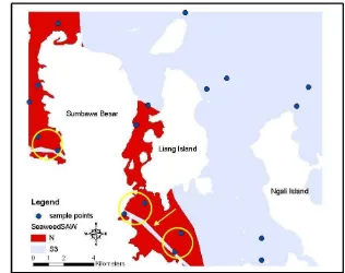
The process interpolation of seaweed cultivation uses simple additive weighting formula (figure 4-3). Figure 4-3 shows that the line across the coast (yellow arrows), describes the existence of S3 marine suitability classes where are parallel with the mainland. This line is generated by spatial interpolation, which will connect the sample points (yellow circle) one to another of the same classes. So in fact, the line with S3 classes should not exist. The S3 classes should appear around the sample point.
4.4 Marine Coastal Suitability using Fuzzy Method
data, the result from the initial process will be different and produce unsuitable marine coastal suitability of zoning. After overlay process phase is calculation in fuzzy set method. Most of the equations are used for semantic model 2 and model 3 as shown in figure 2-1, by using equation (2) and (3) in fuzzy set method. Seaweed cultivation of marine coastal suitability as described in table 2-1 will be converted into fuzzy set process as shown in table 4-2.
Table 4-2. Evaluation criteria of fuzzy set model and membership functions (MF) parameter for seaweed cultivation
Membership function parameter Marine coastal
Characteristic
model b1 b2 d1 d2 Weight
Temperature 2 20 35 6 4 0.1
Salinity 2 12 36.1 16 0.1 0.1
pH 2 6.5 9 1 0.7 0.1
Bright 3 25 - 50 0 0.25
Dissolved oxygen 3 4 - 2 0 0.1
Depth 2 0.9 5.1 0.1 0.1 0.35
The data in table 4-2 also shows definite weight for each physical parameter characteristics. Membership function for physical parameter, mostly uses equation semantic model 2 for physical parameters such as depth, temperature, salinity, and pH, and the others use equation membership function semantic model 3. The fuzzy set conversion into graph of marine coastal characteristic functions are shown in figure 4-4.
Table 4-3. Evaluation criteria of fuzzy set model and membership functions (MF) parameter for pearl oyster cultivation
Membership function parameter Marine coastal
Characteristic
type b1 b2 d1 d2 Weight
Temperature 2 20 34 16 5 0.1
Salinity 2 20 40 17 6 0.1
pH 3 7 9 0.7 0.7 0.1
Bright 3 25 - 50 0 0.1
Dissolve oxygen 3 4 - 2 0 0.1
Depth 2 .0.9 36 0.1 25 0.5
Pearl oyster cultivation of marine coastal suitability as described in table 2-2 will be converted into fuzzy set process as shown in table 4-3.
(a) Seaweed Cultivation
[image:48.612.127.470.134.676.2](b) Pearl oyster Cultivation
The data in table 4-3 also shows definite weight for each physical parameter characteristics. Membership functions for physical parameter mostly use equation semantic model 2 for physical parameters such as temperature, salinity, while for the others membership function of semantic model 3 is used. The fuzzy set conversion into graph is shown in figure 4-5.
Spatial Analysis for Seaweed and Pearl Oyster Cultivation
Seaweed cultivation by spatial polygon map of marine coastal suitability is indicated by spline interpolation, as shown in figure 4-6 (a).
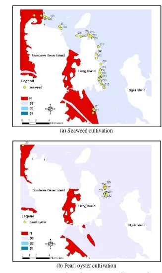
[image:49.612.161.470.435.679.2]The process after overlay phase is fuzzy set method (figure 3-6) using simple visual basic program and the result of the polygon map is described in figure 4-6(a). Calculation using fuzzy set method produced three classes such as N class, S3 class, and S2 class. Pearl oyster cultivation by spatial interpolation of marine coastal suitability as shown in figure 4-6 (b). The process after overlay phase is fuzzy set method (figure 3-6) using simple visual basic program and the result polygon map as described in figure 4-6 (b). Calculation with fuzzy set method produced two classes such S3, S2 class, and S1 class, in the same location.
The process interpolation using fuzzy method for seaweed, will produce polygon map with results as presented figure 4-7. The existence of marine suitability S2 class is show by arrows crossing near the coast (yellow arrows). The line with S2 classification is generated by spatial interpolation, which will be connected between the sample points (black circle) to another sample point with the same classification. So the fact, the line with S2 classification should be did not exist, and only S2 class around the sample point.
4.5. Comparative Evaluation
4.5.1 Seaweed Cultivation
There are 40 points of research of which 30 points are seaweed while the remainder is cultivation of pearl oysters and floating cage nets. This research was conducted in May 2009.
Table 4-4. Point of research of seaweed observations in the field (source: Pramono, 2009)
No Id Existing No Id Existing 1 210 Seaweed 16 272 Seaweed 2 211 Seaweed 17 274 Seaweed 3 212 Seaweed 18 275 Seaweed 4 213 Seaweed 19 280 Seaweed 5 214 Seaweed 20 281 Seaweed 6 215 Seaweed 21 13 Seaweed 7 216 Seaweed 22 14 Seaweed 8 217 Seaweed 23 141 Seaweed 9 218 Seaweed 24 142 Seaweed 10 220 Seaweed 25 143 Seaweed 11 240 Seaweed 26 15 Seaweed 12 241 Seaweed 27 152 Seaweed 13 250 Seaweed 28 17 Seaweed 14 270 Seaweed 29 171 Seaweed 15 271 Seaweed 30 172 Seaweed
.All methods in figure 4-1(a), 4-2(a), 4-6(a), and table 4-4 indicated point of observations for seaweed cultivation that the majority area of marine coastal suitability belongs to S3 classification, based on SAW and fuzzy methods. It means generally less suitable for fisherman to produce seaweed cultivation. Some area marked as S3 and S2 classification but the fishermen not plant as spatial polygon map. Figure 4-8 shows for comparative the three methods for seaweed. It shows that majority classification of marine coastal suitability belongs to N class based on minimum threshold criteria. Only in SAW and fuzzy method that S3 class is higher than N class.
distribution of depth and brightness parameters will be included in N class. Therefore, the marine suitability foe seaweed will be more dominant in N class.
Figure 4-8. The comparative of area for three method for seaweed cultivation
4.5.2 Pearl Oyster Cultivation
Points of research areas for pearl oyster cultivation is the same with seaweed cultivation and 9 points of observations are pearl oyster. The remainder is cultivation of seaweed and the others. This research was conducted in May 2009.
Figure 4-1 (b) shows marine coastal suitability using minimum threshold criteria (maroon is water and the white color is land), the results of this approach indicated that the majority of the areas of marine coastal suitability belongs to N classification which threshold criteria are brightness, depth, and dissolved oxygen. Figure 4-2 (b) shows marine coastal suitability using simple additive weighting (maroon and light blue is water area and white color is land), the results showed that marine coastal suitability is divided into two classifications such as S3 and N classification, and the point of research for pearl oyster cultivation mostly belongs to S3 classification. Figure 4-6 (b) shows marine coastal suitability fuzzy set method (blue and light blue color are water area and white color is land), the results of this approach showed that marine coastal suitability are divided into two classifications such as S3, S2, and S1, so the point of observation belongs S1 and
N 100.0
N 20.7
S3 79.3
S3 94.5
S2 0.4
S1 5.1 0.0
50.0 100.0
Threshold Criteria SAW Fuzzy
Methods
A
rea (
%
S2 classification, which means this is location potential to produce maximum commodity of pearl oyster cultivation.
Table 4-5. Point of research of pearl oyster observations in the field (source: Pramono, 2009)
No Id Existing 1 230 pearl oyster 2 231 pearl oyster 3 232 pearl oyster 4 233 pearl oyster 5 234 pearl oyster 6 237 pearl oyster 7 238 pearl oyster 8 239 pearl oyster 9 123 pearl oyster
All methods in figure 4-1(b), 4-2(b), 4-6(b) and Table 4-5 indicates that points of observation for pearl oyster cultivation, have their own characteristics. Figure 4-9 shows the marine suitable using threshold criteria method which produces N classification.
Figure 4-9 The comparative of areas method for pearl oysters cultivation
The suitable marine using simple additive weighting method produce two classifications: N and S3. S3 classification replies the biggest area than N classification. The suitable marine using fuzzy method produces three classifications: S3, S2 and S1, which means this location is suitable for pearl
N 100.0 N 9.6 S3 90.4 S3 33.6 S2 4.9 S1 61.5 0.0 50.0 100.0
Threshold Criteria SAW Fuzzy
Methods
A
rea (
%
oyster cultivation. Based on table 2-2, the data distribution of pearl oyster cultivation for depth parameter is almost the same for S1, S2, S3 and N classes. Salinity and pH parameters the data distribution is concentrated in S1 class, the data distribution of brightness and DO parameters is concentrated in N class, while the data distribution for temperature is concentrated in S1 class and S2 class with the same numbers of data.
4.5.3 Comparative Three Methods
Table 4-6 show comparisons of all method for seaweed and pearl oyster cultivation. Based on two methods: SAW and fuzzy methods for seaweed cultivation, the majority area of classification belongs to S3 class, where the SAW method produce 79.3% and fuzzy method produce 94.5%, while threshold criteria method produce 100% of N class. SAW method showed that S3 class (79.3%) is the biggest area compare to N class (20.7%). The spatial polygon map for pearl oyster cultivation using threshold criteria method belongs to N class (100%), but the result using SAW and fuzzy method is different. Both methods showed that pearl oyster has a big potential to be cultivated in this location. Based on table 4-6 the use of SAW method for pearl oyster cultivated produced 90.4% for S3 class. The use fuzzy method produced 33.6 % for S3 class, 4.9% for S2 class and 61.5% for S1 class.
Table 4-6. The comparative three methods for seaweed and pearl oyster cultivation
Method Principle
Seaweed Classification (%)
Pearl Oyster
Classification (%)
Com-plexity
N S3 S2 S1 N S3 S2 S1
Threshold
Criteria boolean 100 - -
-
100 - - - low
SAW parametric 20.7 79.3 - - 9.6 90.4 - - moderate Fuzzy parametric - 94.5 0.4 5.1 - 33.6 4.9 61.5 high
fuzzy method, 10 % point of observation in S1 class and 90 % belongs to S3 class. For pearl oyster cultivation based on figure 4-1(b), 4-2(b), 4-6(b), and table 4-5, there are 9 points of observation. In threshold criteria, 100 % point of observation belongs to N class. In SAW and fuzzy methods all points of observation belongs to suitable order, therefore in SAW method 88.9 % belong to S3 class and 11.1 % belong to N class. In fuzzy method, 44.6 % point of observation belongs to S1 class and 55.6 % belong to S2 class, as shows in Table 4-7.
Table 4-7. Percentage of observation point in the suitability area
Method Seaweed (%) Pearl Oyster (%)
N S3 S2 S1 N S3 S2 S1
Threshold Criteria 100 - - - 100 - - -
Simple Additive Weighting 16.7 88.3 - - 11.1 88.9 - -
Fuzzy - 90 - 10 - - 55.6 44.6
V. CONCLUSION AND RECOMMENDATION
5.1 Conclusion
The process of marine coastal suitability classification can be done by threshold criteria approach. Result of the polygon map using this method showed that the seaweed and pearl oyster cultivation at all points of research are not suitable, because all points of observation generally refer to N classification (not suitable). Validation in this method, there are 30 points of observation for seaweed and all of them belong to N class. And 9 point of observation for pearl oyster, all point of observation belongs to N class
The simple additive weighting method, a score is obtained by adding contribution from each attribute, and also should consider that the depth of open waters is the most influential physical parameter compared to the others for seaweed and pearl oyster cultivation. Result of the polygon map of this method for seaweed cultivation explained that two classes such as N class and S3 class. Therefore validation in this method, there are 88.3 % points of observation belong to S3 class and 16.7 % belong to N class. Result of the polygon map for pearl oyster also explained two classes such as N class and S3 class, where 88.9 % point of observation belong to S3 class and 11.1 % belong to N class.
The fuzzy method emphasized on weight and value of membership function spatial marine coastal. Result of the polygon map of this method described that three classes are produced. In seaweed cultivation majority point of observation belongs to S3 class (90 %) but only few point of research belongs to S2 class (10 %) of marine coastal suitability. For pearl oyster cultivation, the calculation produced three classifications: S1, S2 and S3 area. The points of observation are located in suitable marine coastal with S1 class (44.6 %) and S2 class (55.4 %), which means a high potential to produce maximum commodity.
the area is not suitable for seaweed cultivation, SAW and fuzzy methods produced two classifications N and S3 class where the area of S3 class is larger than the area of N class, and most of observation points are located in S3 class (higher than 80 %). The coastal marine suitability for pearl oyster cultivation using minimum threshold criteria method showed that the spatial polygon map majority belongs to N class. The use of SAW produced two classifications such as N and S3 class, where S3 class more larger (higher than 80 %) than N class. And fuzzy method showed that pearl oyster cultivation has a big potential to obtain maximum production compared to seaweed cultivation at the same location. Because the points of observation are located in S1 class (44.6 %) and S2 class (55.6 %).
There are 40 points of research of which 30 points are seaweed cultivation and 9 points are pearl oyster cultivation. The comparisons of three methods for seaweed and pearl oyster cultivation, the fuzzy method is the most accurate because the fuzzy method generates more information in spatial polygon map by giving extra sensitivity in data analysis.
5.2. Recommendation
Because of the limitation of sample points, the analysis spatial interpolation on marine coastal was not perfectly tested. It is would be better have more sample points to support more accurate spatial interpolation analysis.
References:
Aminudin I., 2008, Budidaya Mutiara, http://ikanmania.wordpress.com/2008/01/ 23/aspek-produksi-budidaya-mutiara/
Burrough, P. A., McDonnell, R. A., 1998, Principles of Geographical Information Systems, Spatial Information System and Geostatistics, Oxford
University Press, New York.
Baja, S., Chapman, D.M. and Dragovich, D. 2002. A conceptual model for assessing agricultural land suitability at a catchment level using a
continuous approach in GIS, Division of Geography, School of
Geosciences, The University of Sydney.
http://www.regional.org.au/au/gia/26/828baja.htm
FAO, 1976, A Framework for Land Evaluation, FAO Soil Bulletin 32, Soil Resources Management and Conservation Service Land and Water Development Division. Rome, Italy: FAO
Kilic S., Senol S., Evrendilek F., 2003, Evaluation of Land Use Potential and Suitability of Ecosystems in Antakya for Reforestation, Recreation,
Arable Farming and Residence, Dept. of Soil Science, Faculty of
Agriculture, Mustafa Kemal Univ., Turkey.
Kruger CJC., 2008, Constrained Cubic Spline Interpolation for Chemical Engineering Applications.
Malczewski, J., 1999, GIS and Multicriteria Decision Analysis, John Wiley and Sons, New York, NY.
Malczewski, J., 2006, Integrating multicriteria analysis and geographic information systems: the ordered weighted averaging (OWA) approach,
2006, Department of Geography, University of Western Ontario,
London, Ont. N6A 5C2,