AES BI OFLUX
Ad va n ce s in En vir on m e n t a l Scie n ce s -
I n t e r n a t ion a l Jou r n a l of t h e Bioflu x Socie t y
La n d u se , la n d cove r a n d m a n gr ov e div e r sit y in
t h e I ndone sia n ou t e rm ost sm a ll isla n ds of Rot e
a n d n Da n a
1
Widiat m aka,
2Wiwin Am barwulan,
3Nandi Kusm aryandi,
4Cecep Kusm ana,
2
Priyadi Kardono
1
Depart m ent of Soil Science and Land Resources, Bogor Agricult ural Univ ersit y , Bogor 16680, I ndonesia; 2 Geospat ial I nform at ion Agency , Cibinong, Bogor 16911, I ndonesia;
3
Depart m ent of Forest Ressources Conserv at ion and Ecot ourism , Bogor Agricult ural Univ ersit y , Bogor 16680, I ndonesia; 4 Depart m ent of Silvicult ure, Bogor Agricult ural
Univ ersit y , Bogor 16680, I ndonesia. Corresponding aut hor: Widiat m ak a, w idiat m ak a@ipb. ac.id; widi. widiat m ak a@y ahoo. com
Abst r a ct. I n I ndonesia which h as t housands of islands, t he inv ent or y and evalu at ion of n at ur al r esour ces of islands, including in t he out er m ost islands, should be don e t o pr ovide accur at e and up- t o- dat e baseline dat a t hat can be accessed quickly t o suppor t t he sust ainable m anagem ent of nat ur al r esour ces. The obj ect ive of t his paper is t o pr esent par t of t he invent or y r esult s of nat ur al r esour ces on Rot e and nDan a islands in East Nusa Tenggar a Pr ovince, I ndonesia, especially r egar ding change in land use and land cover fr om 2000 t o 20 14 and t he com posit ion of t he m angr ove ecosyst em at sever al point s of m easur em ent . Land use and land cover wer e int er pr et ed fr om Landsat sat ellit e im agery acquir ed in 2000 and 201 4. Pr im ar y dat a of t he m angr ove wer e obt ained t hr ough m easur em ent s dur ing field sur veys at four st at ions. The r esult s of t he r esear ch indicat ed t hat land use and land cover change in t his out er m ost and r em ot e island wer e gener ally st at ic. Changes in land use and land cover appear ed t o be only slight ly
affect ed by t he populat ion which is st ill few in t he ar ea. Never t heless, m angr ove dest r uct ion has begun.
Dist r ibut ion in all m angr ove st r at a ( seedlings, saplings and t r ees) on Rot e and nDana islands was not spr ead evenly and was differ ent at each st at ion obser ved. At st at ions wher e t he subst r at e was sandy m uds, Rhizophor a m ucr onat a was t he dom inant species. I n t he st at ions wher e t he subst r at e was dom inant ly m uddy, Avicennia alba and Cer iops t agal wer e dom inant . On t he nDana islands, t he m angr ove was found on a plat eau of t he island, wit h Avicennia spp. and Her it ier a spp. which wer e t he dom inant species. This r esearch descr ibes t he diver sit y of t he m angr ove in differ ent locat ions at differ ent st r at a. This descript ion should becom e par t of t he d at abase on t he m angr ove ecosyst em in r em ot e ar ea.
Ke y W or ds: land use and land cover change, Landsat im ager y, m angr ove species, r esour ce invent or y, t r ansect .
I n t r odu ct ion. I ndonesia has 13, 466 islands ( GI A 2014; Widiat m ak a et al 2015) , m ak ing t he count ry t he largest archipelago in t he w orld ( AsianI nfo. org 2015) . I n t hose islands, t here are very div erse biot ic and abiot ic nat ural resources. I ndonesian biodiv ersit y can be list ed in t erm s of flora and fauna as ex am ples: t he count ry has 515 species of m am m als ( 12% of t he w orld’s m am m als, first rank in t he w orld) , 511 species of rept iles ( 7. 3% of t he w orld’s rept iles, t hird rank in t he w orld) , 1, 531 species of birds ( 17% of t he w orld’s birds, fourt h rank in t he w orld) , 270 species of am phibians ( fift h rank in t he w orld) , 121 species of but t erflies ( first rank in t he w orld) , 2,837 species of inv ert ebrat es and 3, 800 species of plant s ( Nandik a 2005; Kusm ana 2011) . Alt hough t he land area of I ndonesia is only 1. 3% of t he surface of t he eart h ( Kusm ana 2011) , it s biodiv ersit y const it ut es an im port ant part of t he w orld’s biodiv ersit y . Howev er, not all of t he nat ural resource diversit y of t hese islands has been w ell-ident ified.
dev elopm ent of t he border region. This dev elopm ent is essent ial t o t he w elfare of people living on t he concerned islands, as w ell as for nat ional defence. The border region has t he pot ent ial for nat ural resources, but has not been w ell m anaged ( NABM 2014) because of t he rem ot e geographic posit ions of t he islands. The resource pot ent ial can v ary, w hich m ay include land resources, nat ural gas, oil, m ineral m at erials, t ropical t im ber, germ plasm and aquat ic resources. So far, t his pot ent ial in I ndonesia has receiv ed m inim al at t ent ion ( Raharj o 2012) and has not been w ell recorded.
Ex ploit at ion of nat ural resources on sm all islands needs t o be preceded by an inv ent ory in order t o plan it s use. Only aft er t he pot ency of resources is k now n, can planning for t heir ut ilisat ion on a sust ainable basis occur ( WCED 1987) . This is t rue for sm all islands because t hey hav e a lim it ed resource capacit y. Sm all islands t end t o hav e lim it ed space, rest rict ed habit at s, low species num bers, and high species endem ism ( Cushnahan 2001) . This has been conceiv ed j oint ly by v arious nat ions, as st at ed by t he Global Conference on t he Sust ainable Dev elopm ent of Sm all I sland Dev eloping St at es ( UNGA 1994) . One part of t he resolut ion st at ed t hat t he sust ainabilit y of t he resources on sm all islands is dependent on t he asset m anagem ent of t hese resources, w hich are generally under pressure. Therefore, effort s should be m ade t o m aint ain sust ainabilit y so t hat ex ploit at ion does not ex ceed t he nat ural carry ing capacit y ( UNGA 1994) . Resource inv ent ory of such islands includes a v ariet y of ecosy st em t y pes, bot h t errest rial and m arine. The v ariet y of ecosy st em t y pes on sm all islands is a pot ent ial resource for fisheries, m ining, agricult ure and forest ry, beach, t ransport , t ourism and ot her indust ries (Cushnahan 2001). The inv ent ory and ev aluat ion of nat ural resources of islands, including t he out erm ost islands, m ust occur t o prov ide accurat e and up- t o- dat e baseline dat a t hat can be accessed quickly t o support t he sust ainable planning and m anagem ent of nat ural resources of t he I ndonesian archipelago. This inv ent ory is im port ant because t he ecosy st em s of t he sm all islands are also ecosyst em s t hat are v ery sensit iv e t o clim at e change ( Birk 2014) . Therefore, a m ore in- dept h underst anding of t he resources is necessary for t he preparat ion of adapt at ion by societ y ( Sm it & Wandel 2006; Mort reux & Barnet t 2009) .
Wit h such a back ground, t he Geospat ial I nform at ion Agency, I ndonesia, in cooperat ion w it h t he I nst it ut e for Research and Com m unit y Dev elopm ent , Bogor Agricult ural Univ ersit y , began t o inv ent ory several sm all and out erm ost islands of I ndonesia. Tw o locat ions t hat w ere invent oried recent ly w ere Rot e and nDana I slands, East Nusa Tenggara. The inv ent ory considered biot ic and abiot ic com ponent s, bot h in t errest rial land and in w at er. The com ponent s of nat ural resources inv ent oried and m apped included onshore abiot ic com ponent s ( soil, geology and clim at e), t errest rial biot ic com ponent s (land cov er, flora and fauna diversit y ), abiot ic com ponent s of w at er ( bat hy m et ry , pH, dissolv ed ox y gen, sea surface t em perat ure, salinit y ) , m arine biot ic com ponent s ( coral reefs, reef fish, bent hos and sea grass beds) , and cult ural com ponent s. Dat a processing w as designed wit h m aps at a scale of 1: 25, 000. The result ing out put of t his w ork w as a m ap album cont aining t he nat ural resource div ersit y m aps at a scale of 1: 25, 000, w hich w as av ailable at t he Geospat ial I nform at ion Agency , I ndonesia. This paper present s part of t his invent ory act ivit y , w hich is land use and land cov er change ov er one decade. The result of t he m angrov e div ersit y m easurem ent s will also be present ed.
for a v ariet y of j uv enile and larv al fish and shellfish ( Cooper et al 1995; Kusm ana 2005, 2014) .
The ex t ent of t he m angr ov e ecosy st em in t he w orld, including in I ndonesia, cont inues t o decline. For ex am ple, from 1980–2005, t he w orldw ide m angrov e forest area declined by 3. 6 m illion ha ( about 20% of t he t ot al area) ( Spalding et al 2010; Van et al 2015) . The m angrov e v eget at ed area in I ndonesia is 3. 2 m illion ha ( GI A 2009; Kusm ana 2011) . Based on t he dat a collect ed by t he Minist ry of Forest ry ( Kusm ana 2011) , t he pot ent ial area w here m ore m angrov es could be plant ed ( including m angrov e v eget at ed areas) is est im at ed t o be 7. 8 m illion ha, w here 30. 7% is in good condit ion, 27. 4% is m oderat ely dest roy ed and 41. 9% is heavily dest roy ed.
I n t heir current condit ion, m angrov e forest s have been dam aged and degraded. As t he m angrov e syst em play s an im port ant role in prot ect ing environm ent , any loss creat es a loss of subsist ence, cash- based liv elihoods and ecological and conserv at ion funct ion ( Valiela et al 2001) . Mangrov e grow t h requires a cert ain environm ent ; m any v ariet ies of m angrov e env ironm ent s also require different growing environm ent s. I n addit ion t o t he ot her plant species, t he land suit abilit y m ay be v alid for different species of m angrov es ( Widiat m ak a et al 2014) . There are m any fact ors t hat det erm ine t he dist ribut ion of a m angrov e, i. e. t idal current s, salinit y, w at er t em perat ure and subst rat es ( Suprihary ono 2000; Kusm ana 2011) . The ideal place for a m angrov e is around a wide beach, river est uary or delt a, w here t he riv er flow s and cont ains lot s of m ud and sand ( Dahuri et al 1996) .
The m anagem ent of forest resources needs t o be based on m apping and inv ent ory ( Van et al 2015) . One of t he m ost used m et hods is rem ot e sensing. Rem ot e sensing and GI S hav e been w idely used for t he sust ainable m anagem ent of t ropical coast al ecosy st em s ( Neuk erm ans et al 2008; Sat y anaray a et al 2011; Nfot abong- At heull et al 2013; Van et al 2015) .
The obj ect iv e of t his paper is t o present part ial result s of t he inv ent ory of t he nat ural resources on t he Rot e and nDana islands, especially regarding change in land use and land cover ov er one decade ( 2000–2014) . This paper will also present a com posit ion of t he m angr ov e ecosy st em at sev eral point s of m easurem ent . Such dat a is int ended t o support t he dev elopm ent and applicat ion of dat abase sy st em s and area st udies.
M a t e r ial a n d Me t h od. The st udy w as conduct ed on Decem ber 2014 on t he Rot e and nDana I slands, East Nusa Tenggara Prov ince. The islands are locat ed bet ween 122o30” -123o25” E and 10o20” - 11o00” S ( Figure 1) . The r esearch area has a dry clim at e, wit h a rainfall av erage of 900–1, 500 m m y ear- 1. The area t hat receives t he m ost rainfall is locat ed in t he sout hern part of t he islands. Rainfall decreases w hen m oving t ow ard t he nort hern part of t he region.
Land use and land cov er w ere int erpret ed from Landsat sat ellit e im agery acquired bet w een 2000 and 2014. The im ages used for t his st udy include Landsat 7 ETM+ ( recorded on 14 Sept em ber 2000) and Landsat OLI ( recorded on 13 Sept em ber 2014) . The supervised classificat ion w as conduct ed, follow ed by field checking. The im age classificat ion w as done using ERDAS I m agine soft w are. The land use and land cov er changes w ere t hen analy sed using ArcGI S soft w are. Land use and land cov er w ere sort ed int o 16 land use-land cov er t y pes following t he st andard im agery int erpret at ion of I ndonesian Nat ional St andard ( 2010) .
Figure 1. Sit uat ion m ap of t he research locat ion.
Figure 2. Schem e of plot m easurem ent .
On each plot , m easurem ent s w ere m ade in t erm s of height ( h) , diam et er at breast height ( dbh) of each st and, st and num ber, species percent age, and t ree densit y. Height w as m easured from t he ground t o t he first branch point and t he t op of t he t ree canopy . Veget at ion dat a w ere analy sed t o det erm ine t he v alue of t he relat iv e frequency, relat iv e densit y , relat ive dom inance and im port ance v alues ( Mueller- Dom bois & Ellenberg 1974; Cox 1996; Odum & Baret t 2005) . The following form ulas w ere used t o det erm ine t he st ruct ure and com posit ion of v eget at ion pioneers:
Transect Line
5 m 2 m 5 m
2 m 50 m
20 m
Seedling
Sapling
I m port ance Value ( I V) = Relat iv e Densit y + Relat iv e Frequency + Relat iv e Dominance
Re su lt s a n d D iscussion. The land use and land cov er of Rot e and nDana islands for t w o analy sis y ears are present ed in Figure 3. Result s of t he land use and land cov er analy sis are present ed in Table 1.
Figure 3. Result of Landsat int erpret at ion.
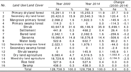
Table 1 Land use and land cov er of Rot e and nDana islands as int erpret ed by Landsat TM satellit e
im ages from 2000 and 2014
Year 2000 Year 2014 Change ( 2000–2014) No. Land Use/ Land Cov er
ha % ha % ha %
1 Prim ary dryland forest 15, 291. 0 11. 9 15, 253. 3 11. 9 - 37. 7 0. 0
2 Secondary dry land forest 20, 420. 0 15. 9 20, 540. 3 16. 0 120. 4 0. 1
3 Mangrov e prim ary forest 2, 068. 2 1. 6 1, 922. 3 1. 5 - 145. 9 - 0. 1 4 Prim ary sw am p forest 114. 3 0. 1 0 0. 0 - 114. 3 - 0. 1 5 Shrub 40, 647. 8 31. 6 46, 146. 9 35. 9 5, 499. 1 4. 3 6 Set t lem ent 441. 8 0. 3 468. 2 0. 4 26. 4 0. 0 7 Bared land 2, 342. 1 1. 8 2, 082. 5 1. 6 - 259. 6 - 0. 2 8 Sav anna 19, 086. 4 14. 8 18, 576. 8 14. 4 - 509. 6 - 0. 4 9 Wat er body 522. 6 0. 4 602. 7 0. 5 80. 2 0. 1
10 Secondary m angrove forest 2, 023. 1 1. 6 1, 979. 1 1. 5 - 44. 0 0. 0
11 Secondary sw am p forest 2. 4 0. 0 0 0. 0 - 2. 4 0. 0 12 Shrub/ sw am p 0 0. 0 145. 9 0. 1 145. 9 0. 1 13 Dry land agricult ure 6, 083. 4 4. 7 4, 519. 5 3. 5 - 1,563.8 - 1. 2
14 Mixed dry land agricu lt ur e 18, 729. 6 14. 6 15, 535. 1 12. 1 - 3,194.5 - 2. 5
I n t erm s of area, land cov er w hich has t he widest area in Rot e and surrounding sm all islands, including nDana I sland is shrub, w hich, in 2000, had an area of 40, 647. 80 ha ( 31. 57% ) ; in 2014, it had an area of 46, 146. 89 ha ( 35. 85% ) . Som e of t he ot her m ain land uses t hat had sufficient ly wide areas in 2014 w ere respect iv ely dry land secondary forest ( 15. 96% ) , sav annah ( 14. 43% ) , m ix ed dry land agricult ure ( 12. 07% ) , and prim ary dry land forest ( 11. 85% ) . I n t erm s of land use and land cov er changes, significant changes occurred only in som e t y pes of land use and land cov er. Land cov er t hat increased in it s ex t ent w as shrub ( by 4. 27% ) , from 40, 647. 80 ha in 2000 t o 46, 146. 89 ha in 2014. Ot her land uses and covers had relat iv ely sm all changes (less t han 1% ) , including shrub/ sw am ps, secondary dry land forest s and set t lem ent s. Meanw hile, t he t y pes of land cov er and land use t hat w ere reduced by a subst ant ial am ount w ere m ix ed dry land agricult ure, w hich suffered an ex t ensiv e decrease from 18, 729. 59 ha in 2000 t o 15, 535. 06 ha in 2014 ( 2. 48% ) and dry land agricult ure farm ing, w hich decreased from 6, 083. 35 ha in 2000 t o 4, 519. 51 ha in 2014 ( 1. 21% ) . Decreases in t he ot her land uses and land cov ers occurred ev enly , but in sm all quant it ies, such as t he prim ary dry land forest , prim ary m angrov e forest , prim ary sw am p forest , sav annah and bare land.
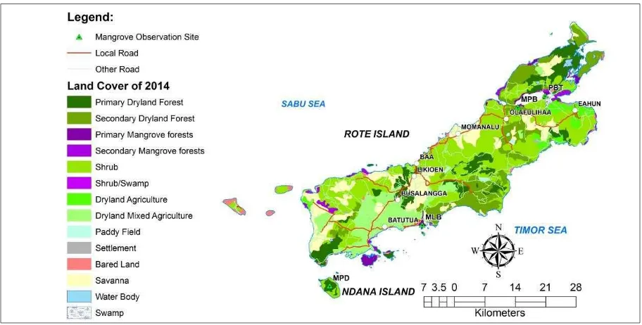
The st at ion of observ at ion, plot t ed against t he result of int erpret at ion of t he land use/ land cov er analy sis of Landsat im agery from 2014 is present ed in Figure 4. These sit es w ere select ed according t o sev eral crit eria: ( i) if a m angrov e area exist ed, (ii) if it w as accessible and possible t o obt ain m easurem ent s, and ( iii) if it w as represent at iv e of t he ent ire island. Result s of t he v eget at ion analy sis of all st at ions of observ at ion are given in Table 2.
Figure 4. Mangrov e observ at ion sit e on Rot e and nDana I slands.
Table 2 Plant v eget at ion analy sis result s in t he m angrov e ecosy st em on Rot e and nDana islands
D Dr Fr Br I V
Mangr ove species Fam ily
t r ee ha- 1 % % % %
Tr ansect of MPB Seedling st r at a
1. Cer iops sp. Rhizophor aceae - 7.14 14.29 4.71 26.14 2. Rhizophor a apiculat a Rhizophor aceae - 21.43 28.57 7.89 57.89 3. Rhizophor a m ucr onat a Rhizophor aceae - 71.43 57.14 87.40 215.97
Sapling st r at a
Rhizopor a m ucronat a Rhizophor aceae - 100.00 100.00 100.00 300.00
Tr ee st r at a
From bot h t he result s of t he analysis and t he result s of t he field observ at ion at t he w it h t he av ailabilit y of seedlings being higher t han saplings.
There is no m angrov e v eget at ion grow ing direct ly on t he beaches. There are t w o lak es on t he island, one of w hich is called t he Red Lak e. Here, Av icennia dom inat es t he m angrove species found. Herit iera w as also found due t o t he relat iv ely dry soil condit ions. The fact t hat on nDana I sland m angrov es are present at t he t op of t he island and not on t he coast al plain m ay indicat e t hat geological lift ing has occurred (Head et al 2001) .
Result s of land use and land cov er analy sis indicat e t hat it seem s, since t he island is rem ot e, land use and land cov er has not significant ly changed ov er one decade. I n t his rem ot e locat ion, t here is only m inim um pressure from populat ion grow t h, w hich is charact erised am ong ot hers, by t he increase of set t lem ent , w hich is not as pronounced as on t he ot her densely populat ed islands. The low pressure from populat ion grow t h is reflect ed in t he relat iv ely low populat ion densit y. Based on st at ist ical dat a ( Rot e Ndao St at ist ics 2014) , t he populat ion of Rot e Ndao is 127, 911 inhabit ant s. The populat ion densit y is relat ively low, only 100 people k m-2. There is ev en a dist rict ( Cent ral Rot e) wit h t he low populat ion densit y of 51 people k m-2.
How ev er, at t ent ion needs t o be paid t o t he decreasing m angrov e area. Mangrove land cov er, bot h prim ary and secondary hav e declined. Decreasing m angrov e area reached 145. 87 ha for t he prim ary m angrov e forest and 43. 96 ha for t he m angrov e secondary forest . As a percent age of island area as a w hole, t he percent age of t his decrease is sm all, only 0. 11% and 0. 03% respect iv ely. How ev er in t erm s of percent age of t he m angrov e forest it self, it is sufficient ly high: 7. 05% and 2. 17% for t he prim ary and secondary m angrov e forest s respect iv ely . This am ount w as equiv alent t o a t ot al conv ersion of 9. 2% , or in absolut e t erm s, 190 ha of m angrov e. Giv en t he increasingly
im port ance of m angrov e in I ndonesia ( Kusm ana 2005, 2011) and t he im port ance of m angrov e forest s for sm all island prot ect ion ( Vannucci 2002; Verm aat & Tham pany a 2006; Muk herj ee et al 2010; Kat hiresan 2012; Lee et al 2014) , t his phenom ena is of concern.
The result s of m angrov e div ersit y m easurem ent show ed t hat t here w as a sufficient ly high diversit y of m angrov e species in t he islands. There w as quit e a div erse species found dom inat ing t he area; it seem s t hat t his is influenced by t he div ersit y of nat ural resources w here m angrov es grow . There are m any fact ors t hat influence t he t y pes of m angrov e species. A research conduct ed by Mendez- Alonzo et al ( 2008) found t hat t here is a relat ion bet w een t he high div ersit y of plant s, in t erm of av erage dbh, t o rainfall v ariabilit y . Salinit y play s also an influence, as discov ered by Lugo et al ( 2007) , prov ing t hat wit h t he increase of salinit y, som e Rhizophora species hav e sm aller st em and leav es. I nundat ion seem s t o affect also m angrov e species ( Wat son 1928; Krauss et al 2006) . Tem perat ure fact ors also hav e an effect on m angrov e species ( Lugo & Pat t erson- Zucca 1977; Lugo & Medina 2014) as w ell as hy droperiod ( Wat son 1928; Pezeshk i et al 1990) , nut rient av ailabilit y ( Feller et al 2007) and subst rat um redox gradient (McKee 1993; Alongi 2009) . I n t erm s of m angrov e div ersit y , t he result s present ed in t his st udy could be considered as an original result of m angrov e. This is due t o t he fact t hat t he locat ion of t his w as in a relat iv ely rem ot e area wit h only m inim al hum an act ivit y dist urbance
Con clusion s. The research w as done in Rot e and nDana I slands, t w o of t he out erm ost islands in I ndonesia. Land use and land cov er changes on t hese out erm ost and rem ot e islands w ere generally st at ic. Changes in land use and land cover appeared m inim ally affect ed by t he populat ion, w hich is st ill m iniscule. Nev ert heless, m angrov e dest ruct ion has begun and t hese areas require prot ect ion
Dist ribut ion in all cat egories ( seedlings, saplings and t rees) on Rot e and nDana islands w as not spread ev enly ( uniform ) , but w as different at each st at ion m easured. At a st at ion w here t he subst rat e w as sandy m uds R. m ucronat a w as t he dom inant species. I n t he area w here t he subst rat e w as dom inant ly m uddy , A. alba and C. t agal w ere dom inant . On nDana island, w here t he m angrov e w as found on t he plat eau of t he island,
Av icennia spp. and Herit iera spp. were t he dom inant species.
ecosy st em at t he t op of nDana island. There are geological processes t hat affect such phenom ena, and research t hat is m ore det ailed on t his subj ect is suggest ed.
Ack n ow le dge m e n t s. The aut hor ack now ledges t he Geospat ial I nform at ion Agency , I ndonesia for financial assist ance wit h t his research.
Re fe r en ce s
Alongi D. M., 2009 The energet ics of m angrov e forest s. Springer, New York , 215 pp. AsianI nfo. org. , 2015 I ndonesia’s Geography . Av ailable at :
ht t p: / / w w w . asianinfo. org/ asianinfo/ indonesia/ pro- geography . ht m . Accessed: Decem ber, 2015.
Birk T., 2014 Assessing v ulnerabilit y t o clim at e change and socioeconom ic st ressors in t he Reef I slands group, Solom on I slands. Geografisk Tidssk rift - Danish Journal of Geography 114( 1) : 59- 75.
Cannicci S. , Burrow s D. , Frat ini S., Sm it h T. J., Offenberg J. , Dahdouh- Guebas F. , 2008 Faunal im pact on v eget at ion st ruct ure and ecosy st em funct ion in m angrov e forest s: a rev iew . Aquatic Bot any 89( 2) : 186- 200.
Cooper J. A. G. , Ram m A. E. L., Harrison T. D. , 1995 The est uarine healt h index : a new approach t o scient ific inform at ion t ransfer. Ocean and Shoreline Managem ent 25: 103–141.
Cox G. W. , 1996 Laborat ory m anual of general ecology . 7t h Edidion. Wm C Brow n Publisher, Bost on, 320 pp.
Cushnahan G. , 2001 Resource use and t ourism on a sm all I ndonesian island. Tourism Recreat ion Research 26( 3) : 25- 31.
Dahdouh- Guebas F. , Puluk k ut t ige J. L. , 2009 A bibliom et rical review on pre- and post - t sunam i assum pt ions and fact s about m angrov es and ot her coast al v eget at ion as prot ect iv e buffers. Ruhuna Journal of Science 4: 28- 50.
Dahuri R., Rais J. , Gint ing S. P., Sit epu M. J. , 1996 [ I nt egrat ed coast al zone m anagem ent ] . PT. Pradny a Param it a, Jak art a, 305 pp. [ in I ndonesian]
Feller I . C., Lov elock C. E., McKee K. L., 2007 Nut rient addit ion different ially affect s ecological processes of Av icennia germ inans in nit rogen v s. phosphorus lim it ed m angrov e ecosy st em s. Ecosy st em s 10: 347- 359.
Geospat ial I nform at ion Agency ( GI A) , 2009 [ I ndonesian m angrov e m aps] . Cent er of Surv ey for Marine Resources, I ndonesian Geospat ial I nform at ion Agency ( I ndonesian GI A) [ in I ndonesian] .
Geospat ial I nform at ion Agency ( GI A) , 2014 [ I ndonesia has 13 466 islands regist ered and georeferenced] [ Art icle] . Av ailable at : ht t p: / / w w w . bak osurt anal. go.id/ berit a-surt a/ show / indonesia- m em iliki- 13- 466- pulau- y ang- t erdaft ar- dan- berk oordinat . Accessed: Sept em ber, 2015 [ in I ndonesian] .
Head J. W. , Greeley R., Golom bek M. P., Hart m ann W. K., Hauber E. , Jaum ann R., Masson P., Neuk um G. , Ny quist L. E. , Carr M. H. , 2001 Geological processes and ev olut ion. Space Science Review s 96: 263- 292.
I ndonesian Nat ional St andard ( I NS) , 2010 [ Land cov er classificat ion] . I ndonesian Nat ional St andard, No. 7645, 28 pp. [ in I ndonesian]
Kat hiresan K., 2012 I m port ance of m angrov e ecosy st em . I nt ernat ional Journal of Marine Science 2( 10) : 70- 89.
Krauss K. W., Twilley R. R. , Doyle T. W. , Gardiner E. S. , 2006 Leaf gas ex change charact erist ics of t hree neot ropical m angrov e species in response t o v arying hy droperiod. Tree Phy siology 26: 959- 968.
Kusm ana C., 2005 Plan of m angrov e rehabilit at ion and coast al forest aft er t sunam i in NAD and Nias. Paper, Work shop on Mangrov e aft er Tsunam i, Medan, April 2005. Kusm ana C., 2011 Forest resources and forest ry in I ndonesia. Forest Science and
Technology 7( 4) : 155- 160.
Spalding M., Kainum a M. , Collins L. , 2010 World at las of m angrov es. Eart hscan, UK and USA, 319 pp.
Suprihary ono, 2000 [ Preserv at ion and m anagem ent of nat ural resources in t ropical coast al region] . Gram edia Pust ak a, Jak art a, 246 pp. [ in I ndonesian]
Unit ed Nat ions General Assem bly ( UNGA) , 1994 Report of t he global conference on t he sust ainable developm ent of sm all island developing st at es. Bridget ow n, Barbados, 25 April- 6 May 1994, Docum ent A/ CONF. 167/ 9, 77 pp.
Valiela I . , Bow en J. L., York J. K. , 2001 Mangrov e forest s: one of t he w orld's t hreat ened m aj or t ropical environm ent s. BioScience 51( 10) : 807- 815.
Van T. T. , Wilson N. , Thanh- Tung H. , Quist houdt K. , Quang- Minh V. , Xuan- Tuan L. , Dahdouh- Guebas F. , Koedam N., 2015 Changes in m angrov e veget at ion area and charact er in a w ar and land use change affect ed region of Viet nam ( Mui Ca Mau) ov er six decades. Act a Oecologica 63: 71- 81.
Vannucci M., 2002 I ndo- w est pacific m angrov es. I n: Mangrov e ecosy st em s. Lacerda L. D. ( ed) , Springer- Verlag, Berlin, pp. 123- 215.
Verm aat J. E. , Tham pany a U. , 2006 Mangrov es m it igat e dam age: a furt her response. Est uarine Coast al and Shelf Science 69: 1- 3.
Wat son J. G. , 1928 Mangrov e forest s of t he Malay Peninsula. Malay an Forest 6: 1–274. Widiat m ak a, Sut andi A. , I sw andi A., Daras U. , Hik m at M., Krisnohadi A. , 2014
Est ablishing land suit abilit y crit eria for cashew (Anacardium occident ale L. ) in I ndonesia. Applied and Environm ent al Soil Science 2014: 743194.
Widiat m ak a, Am barw ulan W., Set iaw an Y. , Purw ant o M. Y. J. , Tary ono, Effendi H., 2015 Land use planning for brack ish w at er shrim p pond in t he nort h coast of Tuban, I ndonesia. I ndonesian Journal of Geography 47( 2) : 194- 211.
World Com ission on Env ironm ent and Dev elopm ent ( WCED) , 1987 Our com m on f ut ure. New York , Ox ford Universit y Press, 383 pp.
Received: 20 Mar ch 20 16. Accept ed: 21 Apr il 2016. Published online: 12 May 20 16. Aut hor s:
Widiat m aka, Depar t m ent of Soil Science and Land Resour ces, Bogor Agr icult ur al Univer sit y, Jalan Mer ant i, Kam pus I PB Dar m aga, 16 680 Bogor , I nd onesia, e- m ail: widi. widiat m aka@yahoo. com ; widiat m aka@ipb. ac. id Wiwin Am bar wulan, Cent er for Resear ch, Pr om ot ion and Collab or at ion, Geospat ial I nfor m at ion Agency, Jalan Raya Jakar t a- Bogor Km . 46, Cibinong, 16 91 1Bogor , I ndonesia, e- m ail: w_am bar wulan@yah oo. com
Nandi Kusm ar yandi, Depar t m ent of For est Ressour ces Conser vat ion and Ecot our ism , Facult y of For est r y, Bogor Agr icult ur al Univer sit y, Kam pus I PB Dar m aga, 166 80 Bogor , I n donesia, e- m ail: nkusm ar yandi@ipb. ac.id Cecep Kusm ana, Depar t m ent of Silvicult ur e, Facult y of For est ry, Bogor Agr icult ur al Univer sit y, Kam pus I PB Dar m aga, 1668 0 Bog or , I ndon esia, e- m ail: ckm angr ove@gm ail. com
Pr iyadi Kar dono, Geospat ial I n for m at ion Agency, Jalan Raya Jakar t a- Bogor Km . 46, Cibinong, 169 11Bog or , I ndonesia, e- m ail: pr iyadi. kar dono@gm ail. com
This is an open- access ar t icle dist r ibut ed under t he t er m s of t he Cr eat ive Com m ons At t r ibut ion License, which per m it s unr est r ict ed use, dist r ibut ion and r epr oduct ion in any m edium , pr ovided t he or iginal aut hor and sour ce ar e cr edit ed.
How t o cit e t his ar t icle: