IURNAL
LANSKAP
INDONESIA
perencanaanlperancangananlpengelolaanltanaman
rssN 1907-3933
IKATAN
ARSITEK LANSEKAPINDONESIA
{tALt)DEPARTEMEN ARSITEKTUR LANSKAP
COMMUNICATING AND EVALUATING
LANDSCAPE
DESIGN
CONCEPTS
ONLINE
WITH
A
VIRTUAT
REALITY
LANDSCAPE
MODEL
Akhmad
Arifin Hadi
Department of Landscape Architecture, Faculty of Agriculture, Bogor
Agricultural University, Indonesia.
Landscape Architecture Program, Faculty
of Agriculture, Ecotrohology and
Landrape Developmen! Anhalt University of Applied Science Germany e-mail: [email protected]
Einar
Kretzler
Master of Landscape Architecture
Program, Faculty of Agriculture,
Ecotrohology and Landscape
Developmen! Anhalt University of Applied Science, Germany
Barty Warren-Kretzschmar Master of Landscape Architecture
Program, Faculty of Agriculture, Ecotrohology and Landscape
Development, Anhalt University of Applied Science, Germany
ABSTRACT
The communication betzoeen designers and users is needed in orfur to maintain a higlt leoel of engagement among the public participants, especially
in
case study euhich isconsidering the emtironment. The objectiae
of
this
researchis
to
inaestigateif
oisualimtion by usingvirtual
Reality(vR)
model is suitable media to communicatelandscape design ideafrom designer to public (users) in case study
situ kutikLake.
It
is answer the questionif
vR
model combineilwith
online.questionnaire can be a methocl to gather public participation in landscape design process for case study tohich is relateil with pttblic and enoironments.The research is started by creating three design alternatiaes of
situ
Leutik Lakein
vR
model by using Quest 3D. The next step is obtnining puhlic feedback nhotLt vR model
and selccting the most preferred landscape design alternatiae. Respondents nre asked
to inoestigate three design altentatioes by doing zoalkthrough andbird aiero
in
thevR
model. After operating vR model, users are asktd to
fulfiu
the online questionnaire. In online questionnaire, respondents are nskertif
tlrcy understand abotri the idea of eachfusign alternatiaes. Respondents are also asked to select the most preferred design
alternatioe and gioe suggestions about
final
design.The results shcno that respondents understand about ideas of each landscape design
alternatioes and agree that
vR
model can be media to communicate landscape designid.ea. The
next
resultis
that
landscape design alternatioe number3 is
the most preferred landscape design chosenby
respondents. The feedbackfrom
responilents about proposed site is supported the statement of sheppard et at (2008) that oisioning by using VR model canffict
awareness,'emotion and motktatioit of community totheir
enoironment-For
site
case zuhichinoolaing publics
and
considering sustainability of enaironment, the use of VR model is aery usefulfor
giting
a goodunderstanding to stakeholders about ideas of landscape designer.
Keywords: aisualization, airtual reality, design, quest 3D
INTRODUCTION
The two
ways
communicationbetween designers
and
users
is neededin
order
to
avoid
misunder-standing
and minimize
mistakesof
final
landscape
design
that
causeharmful
impacts
(Steinitz, 2010). Toavoid the
misunderstanding
it
isimportant
for
designers
to
have abstractionsof
the real
world
andfuture world of
design,both
in
2Dformat
or
3D
visualization
(Lange,2005),
as
media
to
communicate design ideas. There are several waysto do visualization
such asby
usinghand drawing, miniature model,
2Dphoto
montage,3D
still
image,
3Danimation,
3D
printing,
Virtual
Reality (VR) model, etc.
The VR model is a new technology
in
visualization. By VR model, users are
not only
can
seethe
simulation of
future
proposed
design
in
3dimension
model,
but
also
free
toexplore
it
by
doing
walkthrough
inside
model
(www.virtualware.es).It is
assumed
that
by
doing
walkthrough
in
VRmodel
users canhave
virtual
experienceabout their
environments. Nowadays,
the
high
visual qualities and
realism becomeincreasingly
available
in
real-timesoftware
(Bishop, 2005).
Virtual
reality
such asin
game technology isimportant
for
landscape architectureworks
becauseit
canhelp to
make alot of
technical problems easier
tounderstand
by
provided tools
andinformation
handled (Mactu 2008).The idea
of this
researchis
comingfrom
hypothesis
that
3D
real-timeprograms
for
creatingvirfual
reality
games
are
also can
be
used for
visualizing proposed
landscapedesign
in Virtual
Reality (VR) model.The appropriate real-time
software, such as Quest3D, is
neededin
this researchin
order to create VR model. This softwareis
usedfor
developinggame/
virtual world,
product
presentation
and
landscape
walk-through. The reason to choose Quest 3Dfor
creating VR model of the casestudy is,
becausethe published file
from
Quest3D is
in
executable{ile
(*.exe)that
able
to
be
operated by
users
in
any laptop
or
computerswithout installing
specific
software first.The public participation
is
one of
methods to gather
information
about users' responseof
design proposed"The public
participation
is
ye{y
important
becauseit
is
influencing
environmental mediation
and
deci-sion (Arbter, et at,2007). The locationof
landscape
designer
and
stake-holders
are
in
different
continents.Internet
is
.rn
appropriate
tool
needed
in
order
to
do two
way-communications between landscapedesigners
and
stakeholders which
located
in
different
places (Creighton, 2005).HADI, KRETZLER, AND KRETZSCHMAR
The objective
is
to
investigate aboutcapability
of
VR model
for
commu-nicating
landscape
design
idea
to proposed users in site case sfudy Sifu Leutik Lake.It
is answer the questionif
VR
model combined
with
online quesfionnaire can be amedia
to
ga-ther public participationin
landscape design processfor
casestudy which
is
related
with
public
and
environ-ments.METHODOLOGY
The research was
held
between fune and September 2O10. The case study,Situ Leutik
Lake,
is
located
in
themiddle
of
Bogor Agricultural
Uni-versity Campus, Indohesia.Research
Method
The research
method is
qurrntitative andqualitative
methods to conclude answersfrom
respondentsthat
areobtained
from
online
questionnaire.The
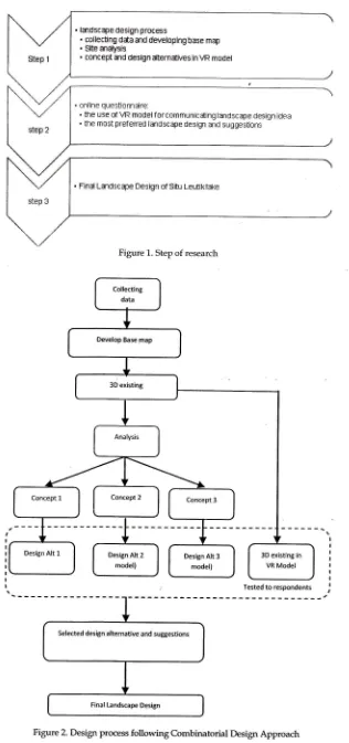
step
of
researchis
started by
collecting datamostly
obtainedfrom
previous
research
of
Situ
Leutik
conductedby
Fatimah,Hadi,
Utami, IQ'isanti,Brodjo,
Pratiwi
(2007) andfinished
by
final
landscape design(Figure
1).
In
this
paper,
authorwrote about
the
suitability
of
the implemented me-thodfor
case studywhich
involving publics
andenvironmenf
e.g.Situ
Leutik
Lake.The
landscape
design
processfollows
the
combinatorial
designapproach
(Steinitz
2010).
In
preliminary
design phase,author
asdesigner
offered three
landscapedesign
alternatives
of
Situ
Leutik
Lake
to
respondents (Figure 2). Thedesign alternatives
are
based
ondegree
of
intervention
to
existingcondition. The three design
alter-natives
and
one existing model
areperformed
as
a
VR model
of
SituLeutik Lake and
tested
to
respon-dents.Visualization Method
ftJni.tnoa
to
createvirtual
reality
of
landscape
model
is
integratedmultimedia"
which
integrate2D,3D
and
real-time software (Figure
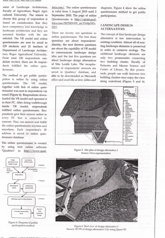
3).The
3D
landform
is
created
in
[image:4.599.221.537.35.708.2]Tested to respondents
Figure 2. Design process followingCombinatorial Design Approach
Google Skecthup and 3D
building
iscreated
in
AutoCAD.
All of
3D models are exported to Quest3D
tobe
combined
properly
and
addedwith
billboard
treesand
commandchannels.
The
billboard trees
are crossedtree
images
that
represent groupsof
trees on site (Table 1). Thebillboard
trees images
selected arethe
imagesthat almost
similar
type. landscape design procss
. c0llecting data ald developlng bffie map
. Slte andysis
. concept and design dternatives in VR model
' online questiDnnaire:
. the use of VR model f or communicating landsDape clesiqn idea . the most prefened landscape design and sugges[on5
. Final Lands[ape Design of Situ Leutiklake
Figure 1. Step of research
with
acfual vegetation. Thebillboard
trees imagesis
efficient
to
be
used because the sizeof
publishedfile of
VR model
is
smaller than using
3D trees.In
theVR model,
respondents, can compare each
laldscape
designalternatives
by
changing
sceneof
eachmodei of
design alternatives byclicking
"D"
key on PC keyboard. Bycomparing
the
models
of
designaltematives
and
existing
condition, respondentscan
seethe
differencebetween
of
them on
actual viewer
position and able
to
selectthe
mostprefurred landscape design
alter-native.The other important commantl
is changing camerafrom
humanview
to
bird
view. The
investigationcamera
is
needed
in
VR
model. Respondents cErn see the overviewof
each landscape
design
altemativesand existing model
by
clicking
key"C"
onPCkeyboard.
The \rR model is also completed
with
orientAtion
map and
arrows
for
showing actual position of VR modeloperator
(respondents).It
is
neededin
order
to
give
information
for
respondents
about
their
current position on model and avoid the loss oforientation
whenever respondentsdoing
walkthrough
inside
the models.The VR model is also completed
with
screen text
for
manual
instructionof
operating
the VR
model. The screen textwill
be onor
off by clicking
key"8"
on
PC
keyboard.
The
manualinstruction
is written
in
Indonesian language,as
all of
respondents are Indonesian.The
VR
model
is
published
asexecute
files
(*.exe)that
able
to
be openedin
each personal computersor
laptopswithout
installing
specific programs.All
of
VR modelsof
eachlandscape
design
altematives
andYR
model
of
existing condition
areput
togetherinto
one VR model that is tested to respondents.Public Participation Method
The
respondents selected
are
sLu-dents
and
teacherstaffs
at
[image:5.597.239.533.38.334.2]Depart-HADI, KRETZLER, AND KRETZSCHMAR
Figure 3. Dagrams
of
visualization Method to create vR landscape modelTable 1. Tree
Type of vegetation / example Biltboard image Deciduous/ Bubber lrees
Deciduous/ Albizia Trees
Deciduous/ any trees beside rubber tfees and albizia trees
Evergreen tree/Pin us me*u si
i
Coconut & Palm trees
Water grass 3D landform in
Google Sketch Up
Trees lmages cropping in Adobe Photoshop
ln Quest 3D
o
Add chanel forVRo
Combining 3D landform and 3D buildingso
Add scene.
Applying materialr
VR Landscape Model of Situ Leutik Lake(Published as *.exe file)
[image:5.597.230.544.362.778.2]HADI, KRETZLER, AND KRETZSCHMAR
ment
of
Landscape
Architecfure,Faculty
of
Agriculture, Bogor
Agri-cultural University. The
reason
to choosethis group
of
respondent isbased
on
consideration
that
they have competencyind
knowledgein
landscape architectureand
they
areassumed
familiar
with the
site selected.The
VR
model and
onlinequestionnaire
are
sent
by
129 students
and
21.teachers of
Department
of
LandscapeArchitec-ture, Bogor
Agricultural
University.From
total
150
respondents
can-didate
invited,
there are36
respon-dents
fulfilled the
online
ques-tionnaire.
The method
to
get public
partici-pation
is
online
by
using
onlinequestionnaire.
The VR
model
together
with link of
online
ques-tionnaire was sent to respondentsvia
email (Figure 4). Respondents down-loaded the VR model and operatedit
in
their PC.After
doingwalkthrough
inside VR
'model,
respondentsfulfilled
online
questionnaire.
Res-pondents givetheir
answer onlinein
every
PC that is
connected
tointernet. They can atlswer and
fuifill
the online questionnaire anytime and
anywhere. Each respondent's
Ip
address
is
saved
in
online
ques-tionnaire database.The
online
questionnaireis
created-by using trial
online
software"Qualtrics"
in
http://www.qual-trics.com/.
Theonline
questionnaireis valid
fuom2
August
2010until
2 September 2010. The pageof
onlineQuestionnaire
is
http://qkial.qual-trics.com/SE?SID:SV aicY3v0p747x 6TO.
There
are twenty
one
questionsin
onlire
questionnaire. Thefirst
threequestions
are
about
respondents'identity,
the next thirteen
questions are about the capabilify of \rR modelto
communicate landscape
designidea and the last
five
questions areabout
landscape design altemativesof
Situ Leutik
Lake.
The
recapitu-lations
of
respondents' answers aresaved
in
Qualtrics'
database, and ableto
be downloaded as Microsoft office and excel file as text, tables anddiagrams.
Figure
4
show the
online questionnairemethod
to
get
public
.,
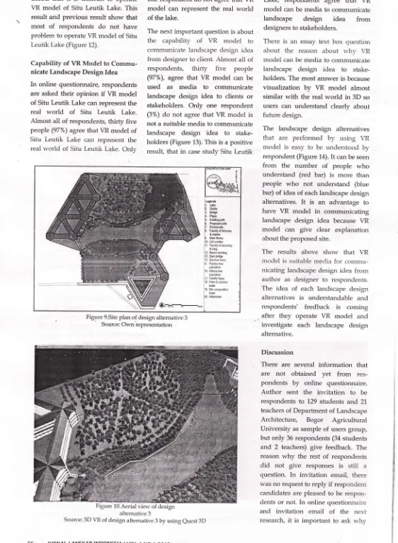
participation.LANDSCAPE DESIGN
ALTERNATIVES
The concept of
first
landscape designalternative
is low
intervention
to existing condition. Almostall
ofexis-ting
landscape elements is preservedin
order
to
conserveecology.
Theadditional
landscape elements
areonly two
promenades comecting
two
building
cluster, Faculty of
Fisheries
and
Marine
Science andCentre
of
Library.
By
this
prome-nade, people canwalk
betweentwo
building
clusters once enjoy theview'
[image:6.599.41.593.23.816.2]along
waterfront
(Figure
5
and
6).Figure 4. Diagram of public participation methoc{
Figure 5. Site plan of design altemative 1 Source: Own representation
Figure 6. Bircl vierv of design altemative 1 Source: 3D VR of design altemative 1 by using euest 3D
[*e Bfts
ExisUng pdh
Main iibrry
tsi coddor
l0 Rslorbuiding
11. Dam bidge 12 Bamb@r$
13. Rubbrte
planldioi
CollectanB r€sult in online databas€
The
second landscapedesign
alter-nativegive
more changingto
lands-cape ssenethan the first
landscape designalternative (Figure
7
and 8).Some
trees
near
waterfront
arelogged paved
promenade.
But
the numberof
treesis
increase onnorth
side. There is alittle
arboretumwith
collection
of
treesthat can be
used for outdoor practicum class.The third
desigp
altemative
iscombination between concept of
design altemative
1 and
designalternative
2.
The
users
are
givenopportuni$
to
enjoy
sight
viewing
on the lake,waterfront
and land.It
isgiving
moreoption
andopportunity
to
various user
preferencesto walk
along
waterfront
or
along
slope(Figure 9 and 10).
Questionnaire
ResultThe public participation
is
a
step after landscape design process finish.The
VR
model was performed
to respondentsin
order to obtain their
opinion and
suggestion
about
VR model andfinal
landscape design.Respondents
&
Ability to
OperateVRModel
From 36
respondentswho fulfilled
online questionnaire, six
of
them arebelow
20
years
old
(17%), twenty
HADI, KRETZLER, AND KRETZSCHMAR
eight
of
them
are
between
21-25years
old
(78%), one
of
them
isbetween
36-40years
old
(3%)
and one of them is over 40 yearsold
(3%) (Figure 11). The most of respondents(94%) are students
and
relatively
young
people
below 25
years
old. Thefirst
questionis
aboutability
toopen and
operate
VR
model. All
respondents
give
positive
Ernswerthat they
can open
VR model
and operateit. In
questionabout ability
to
open
and
operateVR
model, all
respondents
answer
that
they
can open \{R modelin their laptop
or PC (100%).This result
shows
that
VRmodel
in
executablefile
(*.exe) can be openedin
each laptopor
PCwith
Windows
operating systemwithout
installing special software.
3% Respondents'Ages
I Undtr20yearr okl
I 21-25 yearrold
I 26-30yearrold
a 31-l5yea6 old
Figure 8. The bird view image of design alternative 2 Source: 3D VR of design altemative 2 by using euest 3D
[image:7.599.67.545.269.766.2]Figure 7. Site Plan of design altemative 2 Source: Own representation
Figure 11..DiaEgam of Respondents,
Ag"
From the question about
ability
to dowalkthrough
in
VR model,
all
res-pondents give positive answer. They are able to dowalkthrough
inside\{R
model
(100%).It
showsthat
respon-dents
understandabout the
manualof
operating VR model
to do
walk-through
by
using arrows
button
onPC
keyboard.
The manual
in
\lR
model is very important
in
order
togive
explanation
to
respondents abouthow
to operate VR model.Overall,
respondents
do not
havedifficulties to
operateVR model.
In
question
about
the
degree
of
difficulties
to
operate
VR
model,twenty
five
respondents
(69Y") answeredthat
the operation
of
VRmodel
is not difficult and not
easy(neutral),
seven respondents
(19%)answered
it
is
easyto
operate
VRmodel
and
one
respondent
(3%)answered
it
is very easy to operateit
Only
three
respondents(8%)
men-oocls Bridle
Pha
tubthgpdfr PrDSed pah Pmmf,ade
Fdfry o, fishsiB & Mdn [h4
Lsldridor &mg
Rdr hilding
3. Dam bilS
4.8atulffi
16. Albirateplanldion
i7. hilerhes
18. Pah & @ond lB
lbFd !r. ue 2. oc*s
i3 B#Se
!. PWa
5. ErHqpdh
S. Pmpsdpdh
:8. F*ulty df sh6b
i &mahe
3. Maio librry :10 tslcddor
:11 Falllyofeonomy
: &mng
:12. R$Ublildif,g
:13. DamMdF
:16. Abinate
i plantdbn
117 &nifertes
:18 PalmEcmnd
,19. Mixmpsilion
: lEs
,O AfudM HADI, KRETZLER, AND KRETZSCHMAR
tioned
that
it
is difficult to
operateVR model
of
Situ
Leutik
Lake. This resultand
previousresult show
thatmost
of
respondents
do
not
have problem to operate\R
model of Situ Leutik Lake (Figure 12).Capability of
VRModel to
Commu-nicate Landscape Design IdeaIn
online
questionnaire, respondents are askedtheir opinion
if
VR model of SituLeutik
Lake can represent thereal world
of
Situ
Leutik
Lake.Almost
all
of respondents,thirty
five
people (97%) agree that VR modelof
Situ Leutik
Lake
can
represent the realworld
of
SituLeutik
Lake.Onlv
one respondent do not agree that VR
model can
representthe real
world
of the lake.
The next
important
question is aboutthe
capability
of
VR
model
to communicate landscape design ideafrom
designer to client. Almostall of
respondents,
thirty
five
people (97%), agreethat VR model can
beused
as
media
to
communicatelandscape
design idea
to
clients
or stakeholders.Only
one
respondent (3%)do not
agreethat YR model
is not a suitable media to communicatelandscape design
idea
to
stake-holders (Figure 13). This is a positiveresulf
that
in
case study SituLeutik
Lake,
respondents
agree
that
\Ti
model can be media to communicatelandscape
design idea
from
designers to stakeholders.
There
is
an
essaytext box
cuestionabout
the
reason
about
why
VR modei can be media to communicateiandscape design
idea
to
stake-holders. The most answer is becausevisualization
by
VR model
almostsimilar
with
the realworld in
3D so userscan understand
clearly
aboutfuture
design.The
landscape
design
alternativesthat are
performed
by
using
VRmodel
is
easyto
be understood
by respondent (Figure 14).It
can be seenfrom the
number
of
people
who
understand
(red bar)
is
more
thanpeople
who
not
understand
(blue bar) of idea of each landscape designalternatives.
It
is
an
advantage
tohave
VR model
in
communicating landscapedesign
idea
because VRmodel can
give
clear
explanation about the proposed site.The results above
show that
VRmodel
is suitable mediafor
commu-nicating
landscape design ideafrom
author as
designer
to
respondents.The idea
of
each landscape designalternatives
is
understandable
andrespondents' feedback
is
comingafter they
operate
VR
model
andinvestigate
each
landscape
design alternative.Discussion
There
are
several
information
that
are
not
obtained
yet from
res-pondents
by
online
questionnaire.Author
sent
the
invitation
to
berespondents
to
129 studentsand
21teachers of Department of Landscape
Architecfure,
Bogor
Agricultural
University
as sampleof
users group,but only
36 respondents (34 studentsand
2
teachers)give
feedback. The reasonwhy
the
restof
respondentsdid
not
give
responsesis
slilX
aquestion.
In
invitation email,
there was no request toreply
if
respondent cardidates are pleased to be respon-dentsor
not
In
online questionnaire [image:8.598.9.571.49.816.2]and
invitation email
of
the
next research,it
is
important
to
askwhy
Figure 9.Site plan o{ design alternative 3Source: Own representation
altemative 3
Source: 3D VtL of design altemative 3 by using euest 3D
JURNAL LANSKAP INDONESIA I VOL 4 NO
I
20I 2r diffErrlt
:
neutral* easy
I Eryeasy
I
Yes {dgre€}r No{Do no AgreeI
. tadffipe Des€n
I AremdiE 3
E
E Lildspe oeslgn
.3 armt*,
a
E Lands€p€Design
; Allematile1
o
c J
(a) (b)
0 ," zu
l0
Re3poages
(c)
[image:9.598.56.537.42.165.2]HADI, KRETZLER, AND KRETZSCHMAR
Figure L2. (a) Diagram of degree of difficulties of VR Situ Leutik Lake Operation (b) Proporsion of respondents who are agree
that VR Situ L,eutik Lake can be media to communicate landscape design idea of Situ
kutik
Lake (c) Number of respondentswho understand and do not understand abouflandscape design ideas.
Source: Questionnaire Result
respondents cannot
download,
open and operate the VR model.The respondent sample are sfudents
and
teachers
of
Department of
Landscape Architecture.
It
is
only
one
of
department
from
34
depart-ments
in
Bogor Agricultural
Uni
versity.
The sfudentsand
teacherof
other
deparknents
are also
relatedwith
Situ Leutik
Lake.
In
the
next
research,it
isimportant to
ask about users'opinion and
suggestionsfrom
students
and
teachers
of
otherdepartrnents
of
Bogor
Agricultural
University.
But
it
is a
challengefor
author
becausethere
will
be
rnore various suggestions to be concluded.CONCLUSION
Visualization
in
VR model
is
very
important
for
landscape architectureworks.
In
case
study
Situ
Leutik
Lake,
respondents
agree
that
VRmodel
of
Situ Leutik
Lake
canrepresent
the
real
world
of
SituLeutik Lake.
Respondents
alsounderstand about
landscape designidea
from
each
landscape
design alternativesin
VR model. Thisresult
shows
that VR
model
is
suitablemedia
to
communicate
lanclscapedesign
idea
between
author
aslandscape designer and users.
The
feedback
from
respondents showsthat VR model
can stimulatecognition,
awarenessand
emotionsof
usersabout design
development of SituLeutik
Lake. By VR modelof
Situ Leutik Lake,
respondents cansee
the changing
of
environments between existingcondition
and eachlandscape
design
altematives.Forcase
study which
has
strongrelationship
with
environments,visualization
of
the
environmentalchanges
in
VR
model
is
very
important
in
order
to
stimulateresponse
and
feedback
from
respondents.
It
is
supporting
thestatement
from
Sheppard,
et
al
(2008),that visioning workshops
byusing 3D visualization
can influenceparticipant'
engagement,credibility,
cognition,
awareness, emotions,mo-tivation
and
behavior
of
public
participants.
The
integrated multimedia,
i.e.AutoCAD
and
Google Sketchupfor
creating
3
dimensional
model
and Quest 3Dfor
creating VR model, is asuitable method
for
developing \rR
model that
representthe real
world
of Situ
Leutik
Lake. The VR model isvalid
and accurate becauserespond-ents
agree
that VR model
of
SituLeutik
Lake can represent realworld
of
Situ
Leutik
Lake.
One
of
advantage
to
use Quest3D
in
deve-loping
VR model is ihe publishedfile
of
VRmodel
is executablefile
(*.exe)that
can
be
transferred
online
by
or
web
storageand can
be operatedin
any
PC
with
Windows
operating
systemwithout
installing
specificprogram
first.
VR model
in
executable
file
combinedwith
online questionnaire is effective media to beused
for
public
participation in
landscape projects
which
the
lands-capedesigner
and
stakeholders are locatedin
different
placesand hard
to
beinvited in
the same place and the same time.BIBLIOGRAPHY
Arbier,
K.,
Handler,
M.,
Purker,
E.;Tappeiner, G. Trattnigg R. 2007.
The Public Participation Marual; Shnping
The Future
Together.Austrian Society for Environment
and
Technology (OG{'-II)
& Federal Ministryfor
Agricultureand
Forestry,the
Environmentand Water Supply, Vienna.
Bishop
I.D.
2005.
Visualimtionfo,
Pnrticipation: The Adaantages ofReal-Time?ln: Buhmann, 8., Paar,
P., Bishop
I.,
Lange,E
(Eds), Proc.At
Anhalt
University of Applied.Creighton"
I.L.
2005. The Public pnrtici-pation Handbook; Making BetterDecisions Thror.tgh Citizen
lnool-oen rcnt. lossey-Bass. 288p.
Fatimatu I.S., Hadi, A.A.,
Uiami
F.N.H, Krisanti, M., Brodjo, M., Pratiwi, N. T. M. 2007. Knjian Penntaan SituLcutik dan Penangnnan Mutu
Air
unfuk
Pendidikan-resmrch report.Pelaksanaan
Aktivitas
Pengem-bangan Bidang Ilmu
di
IPB pada Kegiatan Pengembangan Infra-struktur Perguruan Tinggi (Kode 2561), DIPA DikjenDikti
No.SP0145 / B -A4.0 / 2007. notpublicated Lange,
E.
2005.lssues and Questions forresearch
in
Communicainguith the.Public lhrough Visualizations.
-
Ln:Buhmann, 8., Paar, P., Bishop, I., Lange, E (Eds), Proc.
At
Anhalt Universitlrof
Applied Science. -Wichmann, Heidelberg.Mach, R. 20[,8. lnteractioe 3D Visualization
of a Riaer Renaturation Measure - A Project Report.
In:
Buhmann, E.,Piebch,
M., Hein, M.,
Didfal
Design.in
Landscape Archi-tecture. Proc.At AnhaltUniver-sity
of
Applied Science.Wich-mann, Heidelb er g: 17 0 -175.
Sheppard, S.R.J., Shaw, A., Flanders, D.,
Burch, S. 2008. Can Visualization
Save
the
World? -Lesson fo,HADI, KRETZLER, AND KRETZSCHMAR
I-andxapc Architeek ftom Visud- Steiniz, C. m10.
Iannwp
Arditcctuts ifitoizing
Inul
kx
tlu
21st CtnhryBuboranar&,
DCtllr,l M:, Digital
ffitn
h;.{€q,dir+p".-^.,,,,Architecture. Proc.l""At
:ilnhalt,,
Univer:rsity.of
Ap
-Wichmann, fleidell5erg: 2-21.
E;,'tudi+"!d",
Digital
2010 Proc,.At