WATE R STORAGE INDE X E STIMATION USING GE OGRAPHIC INF ORMATION SYSTE M
E stimasi Indeks Penampungan Air menggunakan Sistem Informasi Geografis
Agus Wuryanta and Ugro Hari Murtiono
Researcher on Forestry Technology Research Institute on Watershed Management e-mail: agus_july1065@ yahoo.com
ABST RACT
The study aims to estimate water storage index (IPA ) of six sub watersheds (Panjang, Rengas, L egi, Galeh, Parat, and Sraten) in the cachment area of Rawapening lak e by using Geographic Information System. Water storage index can be calculated from average discharge (m3) devided by water requirement (m3) for each land cover/ land use. L anduse information is obtained from Indonesian Topographic Map scale of 1:25.000 as updated by using SPOT image (2006), while surface water availability data was obtained from the ministry of public work s. The results indicate that 1) IPA of Panjang Subwatershed was catego-rized as good condition with an index value of 1,49; 2)IPA of Rengas and L egi sub watersheds were categorized as moderate condition with index value 0,76 and 0,55; 3) IPA of Galeh, Parat, and Sraten sub watersheds was categorized as bad with index value of 0,3, 0,15, and 0,33, this watershed need to be improved especially an effective water resources plan, allocating and distributing of water according to priority establishment.
Keywords: water storage index/IPA, sub watershed health, Geographic Information Syatem
(GIS)
ABSTRAK
Penelitian ini bertujuan untuk memperk irak an Indek s Penampungan A ir (IPA ) dari enam sub DA S (Panjang, Rengas, L egi, Galeh, Parat, and Sraten) di DA S Rawapening menggunak an Sistem Informasi Geografis (SIG). Perhitungan IPA didasark an pada rerata discharge (m3) dibagi dengan jumlah k ebutuhan
air (m3) untuk masing-masing penggunaan lahan. Informasi penggunaan lahan diperoleh dari RBI sk ala 2 : 25.000 yang diupdate dengan citra SPOT (2006). Sementara k etersediaan air permuk aan diperoleh dari data k ementrian PU. Hasil penelitian menunjuk k an bahwa berdasark an perhitungan IPA : 1) Sub DA S Panjang termasuk k ategori baik dengan indek s 1,49. 2) Sub DA S Rengas dan L egi masuk dalam k ategori sedang dengan indek s 0,76 dan 0,55. 3) Sub DA S Galeh, Parat, dan Sraten termasuk dalam k ategori buruk dengan indek s 0,3; 0,15; dan 0,3 sehingga perlu ditingk atk an k hususnya dalam hal perenanaan SDA , alok si, dan distribusi terk ait dengan prioritas yang ditentuk an.
INTRODUCTION
Watershed managements play an important role in the future in many developing coun-tries where watershed management con-cepts and the supporting skills have not been well developed. Population growth and increasing demands for natural re-sources in these countries have exerted severe impacts on watersheds which re-quire careful integrated watershed planning (Low.,1990). Damage to watershed areas can result to a variety of disaster suchs as siltation of rivers, canals, dams, and flood. The number of watersheds that require priority of management were continuously increase from 22 watersheds in 1984 to 39 and 62 watersheds in 1992 and 1998, respectively. Currently, there are about 108 watersheds need management priority. Decreasing of watershed f unction was because of exploitatively natural resource utilizations which was higher than its carrying capac-ity and capabilcapac-ity (Paimin, et al. 2012).
Lake of Rawapening is one of the priority control of environmental issues associated with high sedimentation, resulted from high soil erosion on the catchment area. Sedi-mentation in Lake of Rawapening is tend to be increased from 133,75 m3 in 1993 to
149,22 m3 in 2003. However, the capacity
of water of Lake of Rawapening decreased about 16 million m3 over a periode of 28 years (1976 untill 2004) from 65 million m3 to 49 million m3 (kompas, 2009). If no efforts to save, the existence of the natu-ral lake is threatened and expected in the year of 2012 will turn into mainland. Catchment area of Lake of Rawapening is located in the upper of Tuntang watershed.
Upper watershed ecosystem is an importants part because it has a protective function of water to all part of the water-shed. Land management activities in the upper watershed such as convertion of
for-est land, landuse not in accordance with the carrying capacity of land results land resources degradation. The research objec-tive was to estimate water storage index (IPA) of six sub watersheds (Panjang, Rengas, Legi, Galeh, Parat, and Sraten) in the cachment area of lake of Rawapening by using Geographic Information System.
RE SE ARCH ME THOD
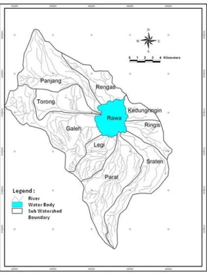
This research was located in catchment area of Lake of Rawapening. Administratively, most of the research area is in Semarang District Central Java Province and is geo-graphically located at coordinate 110o17’
east longitude - 110o30’ east longitude dan
7o5’ south latitude - 7o25’ south latitude.
Research location is illustrated at Figure 1.
The materials and tools used in this research were: (1) Base map: Indonesia topographic map scale 1:25.000 (digital format), Ad-ministrative map, Contour map, dan Road and river network map. (2) Sattelite image: D igital SPOT image recorded 2006. (3) Tools: Software ArcView 3.2, E rdas Imag-ine 8.4, computer, dan Global Positioning System (GPS).
RE SULT AND DISCUSSION
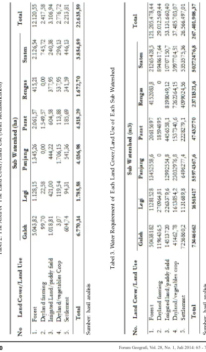
Land cover/land use information is one of the important parameter in watershed man-agement planning. Therefore, accurate and up todate information of land cover/ landuse is necessary to conduct watershed management activity. Information of land cover/land use of catchment area of Lake of Rawapening was obtained from Indo-nesia Topographic Map scale of 1:25.000 (digital format), and has been up dated by using SPOT 2 image 2006 recorded and field check was conducted in 2011. Land cover/land use type in the study area can be devided into 12 types namely rare est, rare private forest, dense private for-est, dense forfor-est, settlement, mix settlement with dry field, estate, dryland farming, irri-gated land (paddy field), shrub, dry land/ vegetable crop, and water body. The area of land use/land cover of each sub water-shed was presented at table 1.
For water requirement calculation, the land cover/land use is reclasified into five main land cover/land use types namely forest, dryland farming, irrigated land/paddy field, dryland/vegetables crop, and settlement. The area of the land cover/land use (after reclassification) was presented at table 2. While water requirement of each land cover/land use of each sub watershed was presented at table 3.
Based on table 2. Forest (consisting of rare forest, rare private forest, dense private forest and dense forest) occupies the largest area (12.120,55 ha). T he largest forest area occured at Galeh sub watershed (5.043,82 ha). While, settlement (consisting of settle-ment and mix settlesettle-ment and dryland) occupies the smallest area (2.213,59).
Average discharge annualy of six rivers (from 2000 to 2009) was obtained from Department of Public Works of Semarang
District as presented at table 4. Value of water requirement and average discharge was used to calculate water storage index (IPA). Average discharge indicates water availibility of each sub watershed. IPA can be calculated by using a formula :
Water storage index (IPA) of each sub wa-tershed in the research area was calculated and as presented at table 5. Value of water storage index (IPA) can be used to evalu-ate sub wevalu-atershed health. Classification of IPA is presented as:
1. IPA < 0,5 (bad)
2. IPA 0,5 – 0,9 (moderate)
3. IPA > 0,9 (good)
Panjang Subwatershed was categorized as good condition with an index value (IPA) of 1,49 as indicates that water availability of the sub watershed is bigger than water requirement. Rengas and Legi sub water-shed has an index value (IPA) of 0,76 and 0,55 was categorized as moderate condi-tion. While Galeh, Parat, and Sraten sub watershed was categorized as bad condi-tion with an IPA value of 0,33, 0,15, and 0,33. Sub watershed wich is having bad condition needs improvement especially an effective water resources plan, allocating and distributing of water according to pri-ority establishment.
CONCLUTION
T
ab
el
1
.
A
re
a
o
f
L
an
d
U
se
/
L
an
d
C
o
ve
r
fo
r
E
ac
h
S
u
b
W
at
er
sh
ed
S
u
m
b
er
:
h
as
il
an
al
is
2. Rengas and Legi sub watershed has an index value (IPA) of 0,76 and 0,55 was categorized as moderate condition
DAFTAR PUSTAKA
Kompas. 2009. Rawa Pening. Kampung itu Berubah Menjadi Rawa. 10 Juni 2009.
Dumairi. 1992. E k onomik a Sumber daya A ir. Pengantar ke Hidronamika, BPFE . Yogyakarta
Low Sim Kwai. 1990. Manual on Watershed Research. ASE AN-US WATE RSHE D PROJE CT. College, Laguna Philippines 4031. 1990.
Paimin, Ugro H Murtiono, and Agus Wuryanta. 2012. A ssesment of Flood V ulnerability at The Upper Tuntang Sub Watershed, Central Java Province.