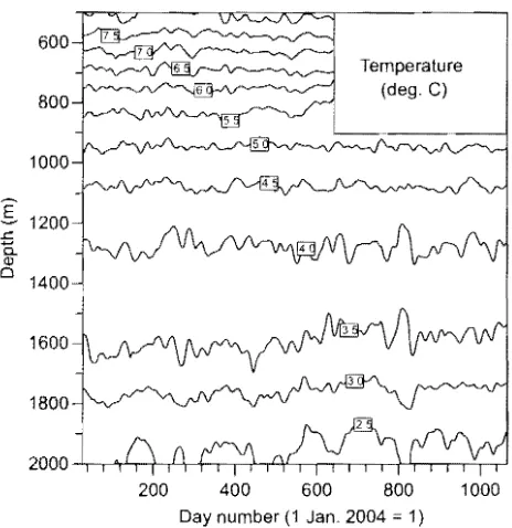
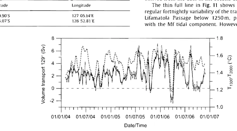
The deep-water motion through the lifamatola passage and its contribution to the Indonesian throughflow
Teks penuh
Gambar


Dokumen terkait
melakukan pengambilan data dari source untuk dimasukkan kedalam webserver, mengirimkan data dari client kepada webserver, hingga pengiriman data dari webserver
Berdasarkan surat penetapan hasil evaluasi kombinasi teknis dan biaya seleksi umum jasa2. konsultansi nomor : 602.1/ 19/ PAN-KONS.2/ PTR-7/ EPROC/ DI STAKO/ V/ 2012 tanggal
[r]
Apabila ada data tanah yang tidak jelas, dapat diisi ke dalam kolom atau lajur maka untuk tidak menghambat pencatatan (Sensus Barang Daerah), kolom atau lajur
Norfaliza (2015) melakukan penelitian dengan judul Analisis Faktor Kesiapan Pemerintah dalam Menerapkan Akuntansi Pemerintah Berbasis Akrual (Studi Kasus pada SKPD
lzlj/df df]ltofljGb'sf ;d:of ePsf la/fdLx?sf nflu lgMz'Ns zNolqmof ul/g] /fKtL cfFvf c:ktfnn] hgfPsf] 5... oxLqmddf clVtof/n] lzIff If]qdf ljBdfg JolyltnfO{ x6fpgsf nflu
‛‛ Campur Kode dan Alih Kode Pemakaian Bahasa Bali dalam Dharma Wacana Ida Pedanda Gede Made Gunung”.. Fakultas Sastra
[r]
