© 2004Kluwer Academic Publishers. Printed in the Netherlands. 197
Is soil degradation unrelated to deforestation? Examining soil parameters
of land use systems in upland Central Sulawesi, Indonesia
Georg Dechert
1,3, Edzo Veldkamp
1& Iswandi Anas
21Institute of Soil Science and Forest Nutrition, Georg-August University Goettingen, Buesgenweg 2, D-37077
Goettingen, Germany.2Department of Soil Science, Bogor Agricultural University (IPB) Jl. Meranti, Campus IPB Darmaga, Bogor 16680, Indonesia.3Corresponding Author∗
Received 28 November 2003. Accepted in revised form 6 February 2004
Key words:deforestation, Indonesia, land use change, soil fertility, soil nutrients, tropical rain forest
Abstract
It is generally assumed that declining soil fertility during cultivation forces farmers to clear forest. We wanted to test this for a rainforest margin area in Central Sulawesi, Indonesia. We compared soil characteristics in different land-use systems and after different length of cultivation. 66 sites with four major land-land-use systems (maize, agroforestry, forest fallow and natural forest) were sampled. Soils were generally fertile, with high base cation saturation, high cation exchange capacity, moderate pH-values and moderate to high stocks of total nitrogen. Organic matter stocks were highest in natural forest, intermediate in forest fallow and lowest in maize and agroforestry sites. In maize fields soil organic matter decreased during continuous cultivation, whereas in agroforestry it was stable or had the tendency to increase in time. The effective cation exchange capacity (ECEC) was highest in natural forest and lowest in maize fields. Base cations saturation of ECEC did not change significantly during cultivation both maize and agroforestry, whereas the contribution of K cations decreased in maize and showed no changes in agroforestry sites. Our results indicate that maize cultivation tends to reduce soil fertility but agroforestry systems are able to stop this decline of soil fertility or even improve it. As most areas in this rain forest margin are converted into agroforestry systems it is unlikely that soil degradation causes deforestation in this case. On the contrary, the relatively high soil fertility may actually attract new immigrants who contribute to deforestation and start agriculture as smallholders.
Introduction
Indonesia is one of the major tropical rainforest areas worldwide, with 10% of the world’s area or nearly 50% of Asia’s remaining tropical rainforest. But In-donesia also has one of the highest deforestation rates worldwide: 1.17% annually in the last decade (FAO, 2001). Although large rainforest areas are still intact in the province Central Sulawesi, the area of annually cleared land increased significantly in the last 5 years (van Rheenen, 2003). The most important cause of deforestation is forest clearing for agriculture (FAO, 2001). Like many rainforest areas in Indonesia, Cent-ral Sulawesi’s uplands are confronted with profound
∗FAX No:+49-551-393310. E-mail: [email protected]
differ-ent climatic conditions (e.g. Guo and Gifford, 2002; Schlesinger, 1986; Davidson and Ackerman, 1993). Declining soil organic C may lead to a reduced effect-ive cation exchange ca4pacity (ECEC) and reduced N stocks. A reduced ECEC may make cations more vulnerable to leaching which after some time of cultiv-ation may result in a reduced ccultiv-ation stock or reduced base saturation. In contrast to annual cropping sys-tems, agroforestry systems with their perennial crops and shade trees have a continuous vegetation cover which provides litter and shading to the soil. If legume shade trees are used, additional N is added to the system by biological N fixation. Soil parameters may improve in these systems compared to annual crops (Beer et al., 1998). The decrease in soil fertility during cultivation is often hypothesized to be a major cause of continuing clearing of forest for agricultural land (e.g. Nye and Greenland, 1965; Andriesse, 1977). This so-called ‘nutrient mining’ is the result of (ecologically unsustainable) land use systems that do not conserve nutrients. The hypothesis is mainly based on studies done in areas with strongly weathered and acidic soils (Andriesse and Schelhaas, 1987; Hölscher et al., 1997; Klinge, 1998; Sommer, 2000). However, large areas in the tropics do not have this kind of soils (e.g. Richter and Babbar, 1991; Sanchez and Logan, 1992) and the hypothesis may be wrong in areas with better soil con-ditions. Our goal was to test the hypothesis that the decrease in soil fertility is a major cause for forest clearing for the case of Central Sulawesi and the forest margin areas of the Lore Lindu National Park. This area is characterized by relatively young and fertile soils. To test the hypothesis we address the following questions:
(a) Which soil characteristics change in these soils after the conversion of forest to agricultural land? (b) What is the influence of length of continuous
cul-tivation of maize (annual crop) and cacao/coffee (perennial crop) on soil parameters?
(c) Does declining soil fertility force farmers in this area to clear new areas for agriculture?
To answer these questions, we sampled 66 sites di-vided over 5 villages covering 4 major land-use sys-tems found in the research area (Maize, agroforestry with cacao (Theobroma cacaoL.) and coffee (Coffea arabicaandC. canephora), and tree-dominated fal-low) analysed them for parameters that indicate the soil fertility and compared these with natural forest sites.
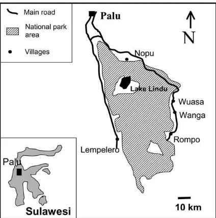
Figure 1. Map of the research region, with national park boundaries and villages where soil samples were taken.
Material and methods
Study area
The study was conducted in the area around the Lore Lindu National Park in Central Sulawesi, Indonesia (Latitude 01◦05′–01◦54′ South, Longitude 119◦54′– 120◦19′ East, Figure 1). The area is mountainous with elevations up to 2300 m a.s.l. and is situated about 150 km south of the equator. This study area is characterized by large, intact submontane and mont-ane rainforests in the National Park area and adja-cent mountains, and mostly deforested valleys and lowlands with a strong encroachment pressure both within and outside the boundary of the National Park. According to the geological map (Sulawesi 2114, 1:250.000) and preliminary surveys mainly crystalline and metamorphic parent material (granite, granodior-ite, quarzgranodior-ite, crystalline slate and phyllite) is found in the research area. Lower parts of the slopes are mostly covered with colluvial material, and the valleys have young colluvial, alluvial and lacustrine sedi-ments. Depending on parent material and position fluvic Cambisols, Fluvisols and Gleysols (classifica-tion following FAO, 1998) occur in the valleys, and eutric or dystric Cambisols and Leptosols are found on the slopes and uplands (unpublished soil survey, 2000).
spa-tial variation. Whereas the main valley of the Palu river receives only 600 mm precipitation (making this area one of the driest in Indonesia), mountain slopes east and west of the valley may have up to 2500– 3000 mm of annual precipitation. The sites selected for this study were 700–1100 m.a.s.l. and received 1400–1800 mm precipitation (unpublished data from 2002, climatic stations of the project). Mean daily temperature was in the range of 20–24◦C, depending on elevation.
Main land-use system in the valleys and alluvial plains is paddy rice; the most common upland crop-ping systems in the research area are maize and agro-forestry with cacao or coffee. Our study concentrated on non-irrigated land use systems because conversion of natural forest rarely leads to the establishment of paddy rice, which is mostly found on land which has been cleared from forest decades ago and is located far away from forest margins.
Sampling sites were identified and sampled in the period from April–September 2001. In five villages (Wuasa, Wanga, Nopu, Lempelero and Rompo,) and their surrounding area a total of 66 sites were sampled (Figure 1). Sites of four major land use systems were selected and sampled: maize (n = 28), agroforestry (n=15), forest fallow (tree- or shrub dominated fal-lows,n = 11), and natural forest (n = 12). Natural forest was sampled on each soil type and landscape po-sition where also other land use systems were sampled. This allowed comparison of land use systems with nat-ural forest as undisturbed situation, excluding soil type effects. Forest fallow is mainly found on newly cleared forest sites which are not immediately cultivated, or on agricultural fields which have been abandoned. Farmers mostly plant annual crops on freshly opened forest sites, and change to agroforestry after several years of continuous cultivation. Both maize and agro-forestry are cultivated continuously, without regular fallow periods. All sites were visited together with the owner of the plot, and the owner was interviewed on site about the age of the site since clearcutting, management practice and previous crops. Sites which had received fertilizer input in the last 5 years were excluded from the survey. Only very few sites were fertilised, but use of fertiliser is increasing, especially in the cacao-agroforestry system. Also sites with un-clear site management history were excluded from the study.
Sampling and sample processing
From each site fifteen soil samples were taken with an auger at randomly chosen points from fixed depths (0– 10 cm and 30–40 cm). Subsamples of five sampling points were mixed to form three composite samples per site to reduce small scale variation within the sites. Site size was between 400 and 3000 m2, soils on most sites were relatively homogenous except sites on steep slopes, where soils could differ between the to or he bottom part of the slope. Within-site variation was mostly due to uneven distribution of ash piles from fresh burning, decomposing treetrunks or har-vest residuals. Per composite sample we transported about 300 g of field-moist soil to the laboratory. Soil was weighed and dried at 45◦C within 1–2 days and passed through a 2 mm sieve. In addition, bulk density was sampled on each site for both depths (0–0.1 m and 0.3–0.4 m) using three 100 cm3steel cylinders per site. Bulk density samples were transported in plastic bags and dried in the laboratory at 105◦C in paper bags and weighed. In forest and forest fallow sites, where sub-stantial amounts of litter were present, litter height was measured and three samples from a 30 cm×30 cm square were taken.
Soil chemical and physical analysis
All soil samples were analyzed for total carbon and nitrogen. The air-dried and sieved soil samples were ground to powder using a ball mill. We determ-ined the total organic C using an automated C & N analyzer (Heraeus vario EL). Exchangeable cations (Ca2+, Mg2+, K+, Na+, Al3+ and H+) were de-termined by percolation with 1M NH4Cl following
the method described in Meiwes et al. (1984). Total phosphorus and Ca, Mg, K, Na, Al, and Fe were de-termined after digestion under pressure with HNO3
following the method described in Heinrichs (1989). Effective cation exchange capacity (ECEC) was cal-culated from exchangeable cations at field pH. Litter samples were analyzed for C and N only. Soil texture was determined using the pipette method.
Data processing
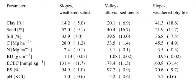
Table 1. Mean topsoil parameters (0-10 cm depth) across land use systems of each soil type, mean (standard deviation).
Parameter Slopes, Valleys, Slopes,
weathered schist alluvial sediments weathered phyllite
Clay [%] 14.2 ( 5.0) 20.1 ( 6.9) 41.3 (18.6)
Sand [%] 52.0 ( 9.1) 40.4 (16.7) 21.9 (11.7)
Silt [%] 33.9 (7.0) 39.5 (13.0) 36.8 ( 7.5)
C [Mg ha−1] 28.0 ( 1.2) 33.5 ( 1.4) 45.5 ( 4.9)
N [Mg ha−1] 2.4 ( 0.1) 3.1 ( 0.1) 3.5 ( 0.3)
BD [g cm−3] 1.14 ( 0.03) 1.08 ( 0.02) 0.95 ( 0.02)
ECEC [mmpl kg−1] 131.4 (11.7) 178.4 (11.3) 160.8 (31.4)
BS [%] 94.9 ( 1.0) 97.2 ( 0.9) 70.6 ( 9.7)
pH [KCI] 5.0 ( 0.6) 5.2 ( 0.6) 5.2 (0.6)
bulk density. Because of the large variation in geo-morphology across the study area, differences of soil parameters between sites can also be caused by dif-ferent soil types of the sites. To avoid this we did not only analyse absolute nutrient concentrations and stocks, but additionally used natural forest sites, which were close to the sites of other land use systems on the same soil type, as reference and calculated relat-ive differences of land use type compared to forest (as percentage). Soil type did not change within sites, and mostly sites around a village were all of the same soil type. Some villages (Wanga, Nopu) had sites on two soil types (slopes and alluvial plain).
For each variable normal distribution was tested (P <0.1, Shapiro-Wilks W-test). We used analysis of variance (one-way ANOVA and Tukey’s means separ-ation) to test for significant effects of soil type, land use system and length of cultivation on soil prop-erties. Pearson’s product moment correlation coeffi-cients were calculated to relate length of cultivation with soil characteristics in maize and agroforestry systems. Data were analyzed using STATISTICA 6.0.
Results
Effects of soil type on soil parameters
Generally soils in the research region were young and fertile, not acidic or deeply weathered (Table 1). 53% had pH(KCl)-values above 5.0. Al-saturation of the
ECEC increased with depth, but in the topsoil never exceeded 15%, only few sites had an Al-saturation which was higher than 10%. Base saturation was mostly above 80%, with Ca contributing about 70%,
Mg contributing about 20% and K contributing about 5%. We grouped the sampled soils into three groups depending on landscape position and parent material. This classification into three soil types corresponded well with the texture analysis (Table 1). Silt percentage was similar in all soil types (33–38%), but sand was highest in soils on weathered schist and lowest in soils on weathered phyllite, whereas clay was high in soils on weathered phyllite and low in sites on weathered schist. Soil on weathered schist showed a tendency to higher bulk density and largest differences of soil parameters between natural forest and cultivated sites, and carbon-, nitrogen stocks and ECEC were generally higher in soils on weathered phyllite than on alluvial sediments or weathered schist (Table 1).
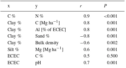
Clay content of soils was positively correlated with C-, Al-, and Fe- stocks, and negatively correlated with bulk density and sand content. Silt content of soils was positively correlated with Mg- stocks. Carbon and Nitrogen concentrations were closely correlated; ECEC was positively correlated with pH (Pearson’s correlation,P ≤0.05). ECEC was correlated (but not significantly) with C concentration (Table 2).
Effects of land use system on soil parameters
Table 2.Pearson’s correlations coefficients (r) and significance (P) between different soil parameters in the topsoil (0–10 cm)
x y r P
C % N % 0.9 <0.001
Clay % C [Mg ha−1] 0.8 0.001
Clay % Al [% of ECEC] 0.8 0.001
Clay % Sand % −0.8 0.001
Clay % Bulk density −0.6 0.002
Silt % Mg [Mg ha−1] 0.6 0.001
ECEC C % 0.5 0.500
ECEC pH 0.7 0.001
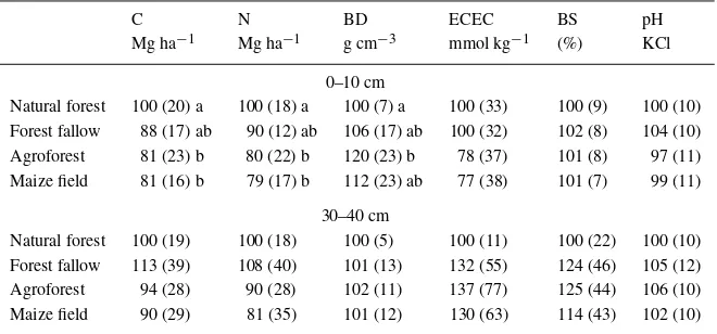
depth, respectively. Decrease of soil C concentration after conversion to maize and agroforestry was as high as 29% and 26% in 0–10 cm and 7% and 8% in 30– 40 cm depth. Soil N concentration decreased after conversion to agroforestry and maize by 30% and 28% in 0–10 cm depth and by 12% and 16% in 30–40 cm depth, respectively (data not shown).
Topsoil bulk density in all land-use systems was higher than natural forest; highest values were found in agroforestry followed by maize (Table 3, ANOVA,
P ≤ 0.05). Topsoil ECEC was similar in forest and forest fallow, and lower in agroforesty and maize, whereas in 30–40 cm depth ECEC increased in con-verted sites compared to natural forest (Table 3, AN-OVA,P ≤0.05). Base saturation showed no changes in the topsoil, but in 30–40 cm depth a tendency to in-crease was observed in converted sites (Table 3). Total P did not show significant changes in different land use systems (data not shown).
Litter was found in substantial amounts only in natural forest and forest fallows, whereas agroforestry systems had only very thin layers of litter. Forests had higher litter biomass stocks than forest fallows (33.0±6.3 and 19.1±6.3 Mg ha−1, respectively), in both systems C and N stocks were around 20% of soil stocks in 0–10 cm depth.
Effects of length of cultivation on soil parameters
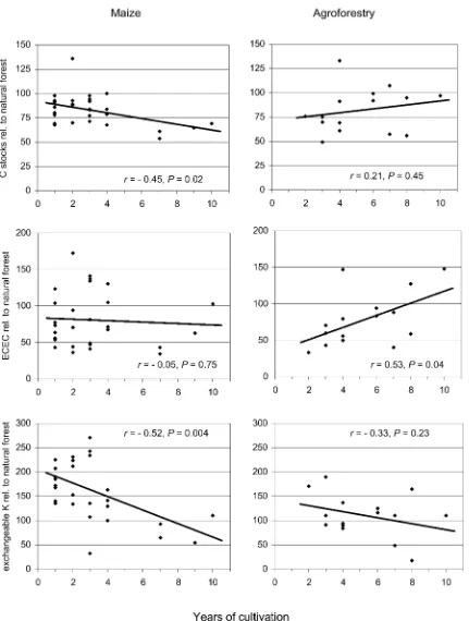
We found statistical significant decrease of topsoil (0–10 cm) carbon stocks in maize during cultivation (P = 0.02). In contrast, changes to agroforestry C stocks were not significantly different from zero (Figure 1a). Changes of N stocks during cultivation were not significant in either system. Bulk density in-creased significantly with age in maize (P = 0.03), but did not change in agroforestry (P =0.57). ECEC
increased in time in agroforestry, but showed no clear trend in maize (P =0.04 and 0.07, respectively, Fig-ure 1b). In maize fields potassium saturation of ECEC decreased strongly in time from high values in one year old sites (P =0.004), in agroforestry no changes were observed in time (Figure 1c). Changes of total P stocks in time were not significant in either land use systems. Results from subsoil (30–40 cm) showed smaller and non-significant changes of soil parameters in time, except for Ca-saturation of ECEC, which in both agroforestry and maize increased in time in 30– 40 cm depth (r = 0.61, P = 0.02 and r = 0.55,
P =0.003, respectively).
Discussion
Effects of land use on soil organic C, N and P
Table 3. C and N stocks, bulk density, ECEC and pH in different land use systems given as percentage relative to natural forest (= 100%), mean (standard deviation), different letters indicate statistically significant differences (ANOVA, Tukey’s Means Comparison,P <0.05, BD=bulk density, BS=base saturation)
C N BD ECEC BS pH
Mg ha−1 Mg ha−1 g cm−3 mmol kg−1 (%) KCl 0–10 cm
Natural forest 100 (20) a 100 (18) a 100 (7) a 100 (33) 100 (9) 100 (10) Forest fallow 88 (17) ab 90 (12) ab 106 (17) ab 100 (32) 102 (8) 104 (10) Agroforest 81 (23) b 80 (22) b 120 (23) b 78 (37) 101 (8) 97 (11) Maize field 81 (16) b 79 (17) b 112 (23) ab 77 (38) 101 (7) 99 (11)
30–40 cm
Natural forest 100 (19) 100 (18) 100 (5) 100 (11) 100 (22) 100 (10) Forest fallow 113 (39) 108 (40) 101 (13) 132 (55) 124 (46) 105 (12) Agroforest 94 (28) 90 (28) 102 (11) 137 (77) 125 (44) 106 (10) Maize field 90 (29) 81 (35) 101 (12) 130 (63) 114 (43) 102 (10)
After conversion of forest into agricultural land cultivation does not always lead to decline of C and N as was found in this study during maize cultiva-tion. Contrary to our findings, several other studies showed that conversion into pastures may lead to both decreases and increases in soil organic matter (e.g. Hughes et al., 2000; Kauffman et al., 1998 and Veldkamp, in press). Increase of soil C is possibly due to the permanent soil cover and high below-ground root biomass formed by the pasture grasses. Decrease or increase of soil organic C and N under pastures has been linked to the productivity and management of pastures (e.g. Post et al., 2000; Fisher et al., 1994). But also conversion into annual crop systems are not always reported to result in soil C decline. Klinge (1998) studied clearing of a secondary fallow forest in a rotation system, which had probably reached a new steady state of C-stocks on a lower level than the original natural forest. Finally, Schroth et al. (2002) measured changes of C following forest conversion in the top 0.3 m of the soil profile, but found no signi-ficant changes in the soil profile if a greater depth was studied (0–2 m).
Although in agroforestry systems soil C and N were significantly lower than in natural forests, these levels did not decrease during cultivation but were stable or had the tendency to increase. In our study area, agroforestry systems are often established on fields previously used for maize cultivation, which are depleted in soil C after some years of maize cultiva-tion. Our results indicate that the agroforestry systems
can stop the decrease in soil organic matter and they may even be able to reverse the trend. The ability of perennial crop vegetation to reverse the negative im-pact of forest conversion was also reported by Post and Kwon (2000). Other studies have found both decreases and increases of soil C in perennial land use systems with cacao or oil palm (review by Schroth et al., 2001). We did not find significant differences of total P between land use systems or in the chronosequence of maize or agroforestry. Managed sites tended to have higher P stocks than natural forests, but these differ-ences disappeared when bulk density was taken into account. In a detailed study in Borneo, Lawrence et al. (2001) did not find a decrease of total P in 200 years of shifting cultivation during time, but changes were found in some more labile P fractions, which we did not measure.
Effects of land use on base cations
natural forest. Total K stocks did not show differences between land use or cultivation period.
Although Ca-saturation of ECEC did not change in the topsoil, we detected an increase of Ca satura-tion and base saturasatura-tion with time at 30–40 cm depth in both land-use systems. Furthermore, Ca and Mg stocks were higher in converted systems compared to forest. The higher Ca and Mg stocks are probably the result of burning of above ground biomass-stocks, res-ulting in high input of bases through ashes. In time the Ca cations are leached to lower parts of the soil pro-file, explaining the increase in Ca saturation. Similar results were found by Klinge (1998) who reported in-creases in pH after clearing in Amazonia. Reiners et al. (1994) and Kauffman et al. (1998) reported increase of Ca-stocks and base saturation in pasture-soils com-pared to forests. In their review of 100 studies in Amazonia McGrath et al. (2001) concluded that con-version of forest to slash and burn agriculture lead to increased pH, bulk density and Ca saturation of ECEC. The effect of increasing Ca saturation with time in agroforestry systems cannot be explained by ash-input through burning alone. Burning of biomass will raise pH and base cation concentration of the soil, and burn-ing of harvest residuals and weeds may be responsible for this accumulative effect in maize, where burning of harvest residuals and weeds is part of the mange-ment. However, burning is not part of the management in agroforestry (weeds are only cut frequently). The increased values compared to natural forest are the res-ult of initial burning, but the continuing increase with time seems to be the effect of an ongoing process. One hypothesis that may explain this increase is the ‘nutri-ent pumping’ effect of deep rooting crop- and shade trees in agroforestry systems: leaf litter and frequent cutting of crop- shade trees and weeds bring nutrients to the soil which were taken from deeper soil layers by the tree-roots. However, the scale of this effect re-mains largely unknown (Sommer, 2000). In our study on soils with moderate pH and high reserves of base cations we did not find significant changes of pH with time and land use systems did not show differences in pH.
Effect of soil fertility on the stability of forest margins
Our study demonstrates that relatively fertile soils dominate the region. Farmers reported during inter-views that systematical use of fallow periods to main-tain soil fertility had been practiced in earlier times in some villages, but presently most plots were under
permanent cultivation. Newly cleared land is normally converted to perennial plantations (cacao and coffee) after a few years of maize culture. Soil fertility was still relatively high after several years of continuous cultivation: Maize was reportedly grown up to 8 times without fertilizer input or fallow period with still reas-onable harvests (about 1 ton ha−1). Strongly degraded soils which only support a short cropping period were rare.
Although we measured declining soil C and N-stocks following conversion, we did not find decreases in cation-stocks with the exception of Potassium. Base saturation actually increased after forest clearing. The change after some years of annual maize-culture to agroforestry may be an adaptation of the farmers to reduced C- and N-stocks and ECEC in maize as agro-forestry seems to stabilize the soil parameters and may even accumulate C and N in time.). However, several other reasons are possible which make farmers change to the perennial system. Apart from soil degradation during maize cultivation, also weed problems in the annual system, lower labour input and higher profit-ability of the agroforestry system may cause farmers to switch to agroforestry. Our study did not test these hypothesis.
this cultivation practice would have to be studied in detail.
Conclusions
In this specific setting of the study on relatively fer-tile soils our results do not support the hypothesis that forest conversion is caused by soil degradation dur-ing agricultural land use. Heavily degraded soils are rare in the study area. Agroforestry systems are rel-atively stable from soil fertility perspective, at least in the age-classes that we investigated in this study, and maize, which would lead to soil degradation, was mostly grown continuously only for several years be-fore perennials were planted. However, the study does not provide evidence that the change towards agro-forestry is driven by soil fertility objectives or other (e.g. economic) reasons.
We conclude that ongoing forest clearing in the rainforest margin of Lore Lindu National Park was not driven by soil degradation, and must be attributed to other factors, which we did not test (immigration, population growth, expansion of agricultural area per farmer etc.). The high soil quality found in the re-search region compared to other areas in Indonesia may actually attract migrants, who clear land and start agriculture as smallholders.
Acknowledgements
This study was conducted as subproject D4 of the research program ‘Stability of rainforest margins’ (STORMA), co-managed by the Universities of Goet-tingen, Kassel, Bogor and Palu. The program was funded by DFG (Deutsche Forschungsgemeinschaft). We thank the laboratory staff members of IBW, Uni-versity of Goettingen and of STORMA, Palu for their support. We thank H. Kreilein and A. Oltchev, Insti-tute of Bioclimatology, University of Göttingen, for climatological data.
References
Andriesse J P 1977 Nutrient level changes during a 20 year shift-ing cultivation cycle in Sarawak (Malaysia). In Proceedshift-ings conference on classification and management of tropical soils. pp. 479–491. Malaysian Society of Soil Science, Kuala Lumpur. Andriesse J P and Schelhaas R M 1987 A monitoring study of nu-trient cycles in soils used for shifting cultivation under various
climatic conditions in tropical Asia. II. Nutrient stores in bio-mass and soil – results of baseline studies. Agric. Ecosyst. and Environ. 19, 285–310.
Beer J, Muschler R, Kass D and Somarriba E 1998 Shade man-agement in coffee and cacao plantations. Agrofor. Syst. 38, 139–164.
Davidson E and Ackerman I 1993 Changes in soil carbon invent-ories following cultivation of previously untilled soils. Biogeo-chemistry 20, 161–193.
FAO 1998 World reference for soil resources. World soil resources reports 84, FAO, Rome.
FAO 2001 FAO statistical databases 2001, FAO, Rome.
Fisher M, Rao I and Ayarza M 1994 Carbon storage by introduced deep-rooting grasses in the South American savannas. Science 371, 236–238.
Guo L B and Gifford R M 2002 Soil carbon stocks and land use change: a meta analysis. Glob. Chang. Biol. 8, 345–360. Heinrichs H 1989 Aufschlussverfahren in der analytischen
Geo-chemie (1). Labor Praxis 12, 1140–1146.
Hölscher D, Möller R, Denich M and Fölster H 1997 Nutrient input-output budget of shifting agriculture in Eastern Amazonia. Nutr. Cycling Agroecosyst. 47, 49–57.
Hughes R, Kauffman J and Jaramillo V 2000 Ecosystem scale im-pact of deforestation and land use in a humid tropical region of Mexico. Ecol. Appl. 10(2), 515–527.
Kauffman B J, Cummings D L and Ward D E 1998 Fire in the Amazon 2. Biomass, nutrient pools and losses in cattle pastures. Oecologia 113, 415–427.
Klinge R 1998 Wasser- und Nährstoffdynamik im Boden und Best-and beim Aufbau einer Holzplantage im östlichen Amazonase-biet. Göttinger Beiträge zur Land- und Forstwirtschaft in den Tropen und Subtropen 122.
Lawrence D and Schlesinger W 2001 Changes in soil phosphorous during 200 years of shifting cultivation in Indonesia. Ecology 82, 2769–2780.
McGrath D, Smith C, Gholz H, de Assis O and 2001 Effects of land-use change on soil nutrient dynamics in Amazonia. Ecosystems 4(7), 625–645.
Meiwes K, Hauhs M, Gerke H, Asche N, Matzner E and Lamersdorf N 1984 Chemische Untersuchungsverfahren für Mineralböden. Berichte des Forschungszentrums Waldökosysteme 7. Nye P and Greenland D 1965 The soil under shifting cultivation.
Technical communication 51, Commonwealth Bureau of Soils, Harpenden, UK.
Post W and Kwon K 2000 Soil carbon sequestration and land-use change: processes and potential. Glob. Chang. Biol. 6, 317–327. Reiners W, Bouwman A, Parsons W and Keller M 1994 Tropical rain forest conversion to pasture: Changes in vegetation and soil properties. Ecol. Appl. 4(2), 363–377.
Richter D D and Babbar L I 1991 Soil diversity in the tropics. Adv. Ecol. Res. 21, 315–389.
Sanchez P A and Logan T J 1992 Myths and Science about the Chemistry and Fertility of Soils in the Tropics.InMyths and Science of Soils of the Tropics. Ed. R Lal and P A Sanc-hez. pp. 35–46. SSSA Special Publication, Madison, Wisconsin, USA.
Schlesinger W 1986 Changes in soil carbon storage and associ-ated properties with disturbance and recovery.InThe changing carbon cycle-a global analysis. Ed. J Trabalka and D Reichle. pp. 194–220. Springer, New York
Schroth G, D’Angelo S, Teixeira W, Haag D and Lieberei R 2002 Conversion of secondary forest into agroforestry and monocul-ture plantations in Amazonia: Consequences for biomass, litter and soil carbon stocks after 7 years. For. Ecol. and Manage. 163, 131–150.
Sommer R 2000 Water and nutrient balance in deep soils un-der shifting cultivation with and without burning in the eastern amazon. Dissertation University of Göttingen, Cuvillier, Göttin-gen.
Van Rheenen T, Elbel C, Schwarze S, Nuryartono N and Zeller M (in press) Encroachments into Primary Forests: Are They Really Driven By Despair. In Land Use, Nature Conservation and
the Stability of Rainforest Margins in Southeast Asia. Springer, Berlin.
Veldkamp E 1994 Organic carbon turnover in three tropical soils under pasture after deforestation. Soil. Sci. Soc. Am. J. 58, 175– 180.
Veldkamp E (in press) Changes in soil carbon stocks following conversion of forest to pasture in the tropics.InNotes from Un-derground: Soil Processes and Global Change. Ed. E A Holland. NATO ASI Series, Springer, Berlin.
207
Village LUS Age Soil- BD Clay Sand Silt pH KCl C mg g−1 N mg g−1 P mg g−1 ECEC mm kg−1 BS K % of ECEC Ca % of ECEC
years type % % % mean SE mean SE mean SE mean SE mean SE % mean SE mean SE
1 NF 1 1.15 16.4 46.7 36.9 4.8 0.3 27.7 3.5 2.5 0.2 0.4 0.0 132.9 66.3 98.40 2.0 0.7 64.8 0.2
1 NF 1 1.01 n.m. n.m. n.m. 5.0 0.5 41.8 5.6 3.5 0.4 0.3 0.0 154.6 64.7 98.70 2.7 0.7 78.0 4.9
1 SF 1 0.93 7.2 71.5 21.3 4.4 0.3 27.1 4.6 2.3 0.3 0.2 0.0 59.7 9.3 99.37 4.1 1.0 65.4 14.4
1 SF 5 1 1.03 22.8 39.9 37.3 4.4 0.3 32.1 5.2 2.9 0.8 0.4 0.1 106.0 15.0 97.10 4.0 1.3 62.7 5.9
1 AF 10 2 1.01 n.m. n.m. n.m. 5.1 0.2 30.5 2.8 2.7 0.2 0.8 0.0 197.1 14.5 99.61 2.2 0.4 76.0 1.8
1 MF 2 1 1.21 6.8 71 22.2 5.5 0.2 24.4 0.6 1.9 0.1 0.2 0.0 94.2 16.4 84.77 4.4 1.1 78.4 1.3
1 MF 2 1 1.21 10 43.1 46.9 4.4 0.1 23.3 1.9 2.0 0.1 0.4 0.0 48.0 5.3 97.48 4.2 0.8 66.1 3.9
1 MF 10 2 1.21 n.m. n.m. n.m. 4.8 0.1 18.2 1.7 1.7 0.1 0.7 0.0 136.8 11.4 85.94 2.2 0.2 73.6 1.4
1 MF 1 2 1.15 15.2 25.4 59.4 4.7 0.1 21.6 1.5 2.1 0.2 0.7 0.1 138.8 28.0 98.56 2.7 0.4 69.5 2.2
1 MF 2 1 0.94 15.2 53.4 31.4 4.5 0.3 23.5 12.5 1.6 0.8 0.4 0.1 58.3 23.4 95.51 4.5 1.5 70.2 11.4
2 NF 1 0.72 21.6 51.3 27.1 5.8 0.3 62.8 12.9 5.8 1.2 0.8 0.1 319.1 55.9 33.54 2.1 0.2 71.1 5.3
2 NF 1 0.94 18 51.5 30.5 5.2 0.3 31.9 1.7 3.2 0.1 1.1 0.1 167.3 30.8 99.04 5.2 0.6 68.1 5.2
2 SF 2 1 1.20 9.2 47 43.8 5.7 0.1 23.7 1.9 2.5 0.2 0.5 0.1 157.7 14.4 98.85 3.3 1.8 83.6 3.3
2 AF 7 1 1.41 13.2 57 29.8 4.7 0.3 15.3 2.3 1.2 0.2 0.7 0.0 96.6 12.7 98.14 4.0 0.9 81.1 1.7
2 AF 4 2 1.29 10 37.7 52.3 4.7 0.1 17.9 1.1 2.1 0.1 0.9 0.1 122.6 25.9 88.42 3.4 0.1 71.7 12.3
2 MF 4 1 1.17 12 46.7 41.3 6.5 0.4 25.4 1.3 2.5 0.2 1.1 0.5 316.2 115.5 97.76 3.7 0.5 83.5 2.9
2 MF 7 1 1.42 12.8 50.5 36.7 4.9 0.2 16.2 1.8 1.4 0.2 0.6 0.1 105.8 18.3 91.87 3.4 0.3 78.7 2.4
2 MF 1 1 1.18 8.8 45.3 45.9 5.6 0.5 21.5 3.1 2.3 0.4 0.8 0.2 131.5 13.1 87.39 6.9 3.4 76.3 5.9
2 MF 7 1 1.44 12.8 52.7 34.5 4.7 0.2 14.0 3.1 1.6 0.3 0.6 0.1 81.7 18.8 99.03 2.3 0.7 76.7 2.4
3 NF 1 1.01 12.8 54.6 32.6 5.0 0.5 25.9 6.0 2.6 0.6 0.7 0.2 181.8 44.4 99.10 2.6 0.3 74.4 5.2
3 NF 1 1.03 29.6 34.2 36.2 5.2 0.4 30.3 7.5 2.8 0.6 0.5 0.1 186.8 69.8 96.28 2.6 0.6 59.6 2.1
3 NF 1 0.68 n.m. n.m. n.m. 4.2 0.2 59.6 11.7 4.4 0.8 0.5 0.1 116.7 18.3 98.45 5.2 0.9 48.6 24.1
3 SF 2 1 1.10 18.4 45.5 36.1 4.5 0.3 24.0 2.2 2.2 0.2 0.5 0.1 176.4 25.0 99.47 3.1 0.8 49.9 9.3
3 SF 3 1 1.20 12.4 54.4 33.2 5.0 0.5 18.4 9.0 1.7 0.8 0.7 0.1 124.7 25.8 96.94 4.6 1.3 65.1 9.2
3 AF 7 1 1.37 n.m. n.m. n.m. 5.0 0.6 22.4 4.7 1.9 0.3 1.0 0.2 161.8 34.0 97.71 1.3 0.4 76.8 4.8
3 AF 2 1 1.34 n.m. n.m. n.m. 4.2 0.1 16.3 0.6 1.2 0.1 0.5 0.0 60.0 10.8 98.84 4.5 1.3 64.9 5.4
3 AF 3 1 1.32 12.0 60.4 27.6 4.3 0.2 15.2 1.5 1.3 0.1 0.6 0.1 79.9 4.6 99.35 2.9 0.1 71.6 2.2
Appendix 1. Continued
Village LUS Age Soil- BD Clay Sand Silt pH KCl C mg g−1 N mg g−1 P mg g−1 ECEC mm kg−1 BS K % of ECEC Ca % of ECEC
years type % % % mean SE mean SE mean SE mean SE mean SE % mean SE mean SE
3 AF 8 1 1.28 12.4 54.5 33.1 5.0 0.2 21.3 1.4 1.7 0.1 0.6 0.1 108.1 11.4 97.04 4.3 1.5 66.4 0.9
3 MF 3 1 1.27 n.m. n.m. n.m. 4.7 0.2 17.4 1.4 1.5 0.1 0.7 0.0 90.3 11.1 94.93 6.4 3.3 55.5 1.4
3 MF 3 1 1.27 12.0 59.5 28.5 4.6 0.2 18.7 0.7 1.4 0.1 0.5 0.0 74.7 9.2 99.29 6.2 1.0 70.9 4.3
3 MF 3 1 1.20 11.2 57.6 31.2 4.9 0.7 20.1 2.8 1.5 0.1 0.4 0.0 86.8 30.3 99.74 7.1 0.8 66.3 5.4
3 MF 1 1 1.01 17.2 47.1 35.7 4.6 1.0 25.9 2.2 1.9 0.0 0.4 0.1 118.2 43.8 98.59 5.9 1.2 46.5 12.1
3 MF 1 1 1.14 12.4 59 28.6 5.2 1.5 20.0 0.2 1.7 0.2 0.4 0.1 141.1 54.9 98.49 3.7 0.1 77.0 4.0
4 NF 2 1.10 14.4 69.6 16 5.7 0.5 41.0 6.0 3.4 0.4 0.7 0.1 247.8 85.3 97.46 2.5 0.7 86.0 3.7
4 NF 2 1.07 20.8 49.4 29.8 4.5 0.4 29.1 2.5 2.9 0.3 0.7 0.0 134.8 26.8 98.48 1.9 0.5 73.9 8.3
4 NF 2 1.12 n.m. n.m. n.m. 5.8 1.0 38.1 7.9 3.7 0.5 0.7 0.0 219.6 52.1 87.60 1.7 0.5 89.0 4.3
4 SF 4 2 0.98 16 61.9 22.1 5.9 0.2 43.0 4.5 3.8 0.2 0.7 0.0 271.2 15.0 93.26 3.8 1.8 82.8 4.2
4 SF 2 1.10 22.8 51.3 25.9 5.6 0.3 32.0 5.0 3.1 0.4 0.6 0.1 207.6 24.4 95.35 2.5 0.5 82.0 0.7
4 SF 3 0.99 28 26.6 45.4 4.9 0.4 38.2 8.0 3.8 0.8 1.2 0.3 218.4 17.7 95.06 3.1 1.3 74.3 6.9
4 SF 2 1 1.10 15.6 59.2 26.2 6.0 0.2 38.0 2.4 3.2 0.0 0.8 0.1 254.6 75.8 95.22 2.2 0.2 86.1 3.8
4 SF 10 2 1.05 25.6 18.2 56.2 5.1 0.2 34.1 4.2 2.9 0.2 0.8 0.1 228.7 36.1 94.66 1.4 0.3 77.0 2.5
4 AF 3 2 1.22 n.m. n.m. n.m. 5.0 0.1 23.4 1.4 2.3 0.1 0.8 0.1 115.2 7.1 93.78 4.2 1.3 78.5 2.9
4 AF 6 3 1.06 28.4 33.4 38.2 4.7 0.3 35.5 2.8 3.4 0.2 1.0 0.3 159.6 23.3 96.75 2.7 0.5 68.9 3.4
4 AF 4 2 1.06 31.2 13.2 55.6 5.5 0.1 47.7 6.0 4.4 0.4 1.7 0.1 282.1 9.6 98.97 1.8 0.4 81.3 1.7
4 AF 4 2 1.11 6.8 53.8 39.4 5.3 0.1 23.6 1.1 2.4 0.1 0.7 0.0 150.8 11.1 97.58 3.0 0.8 78.8 0.9
4 AF 3 2 1.21 n.m. n.m. n.m. 4.3 0.2 15.2 3.6 1.6 0.5 0.9 0.1 136.2 11.1 99.06 2.0 0.5 70.9 2.8
4 AF 6 2 1.14 n.m. n.m. n.m. 5.7 0.3 32.2 7.9 3.1 0.6 0.6 0.0 180.7 51.8 99.85 2.5 0.9 86.9 0.5
4 MF 4 2 1.21 15.2 45.2 39.6 5.7 0.1 31.4 2.9 2.9 0.3 0.8 0.1 201.0 13.0 99.35 3.6 0.5 76.8 1.2
4 MF 1 3 1.06 28.8 28.6 42.6 4.1 0.0 33.4 1.1 3.1 0.2 0.4 0.0 82.5 6.9 99.81 3.7 0.2 46.7 4.2
4 MF 3 3 0.94 20.8 39.2 40 4.7 0.4 37.3 3.7 2.8 0.3 0.5 0.1 154.6 31.6 98.97 6.0 2.1 68.4 13.4
4 MF 2 3 0.99 24 28.6 47.4 4.9 0.1 34.3 3.6 3.4 0.3 1.5 0.0 180.1 20.9 99.22 3.4 1.0 74.0 1.7
4 MF 4 2 1.19 17.6 51.6 30.8 4.9 0.0 27.0 2.3 2.5 0.2 0.6 0.1 129.4 6.4 98.56 3.1 0.5 78.9 0.6
4 MF 1 2 0.87 29.2 25.9 44.9 4.5 0.2 37.7 5.1 3.4 0.4 1.2 0.2 141.8 4.6 98.06 4.6 0.2 65.6 5.7
4 MF 1 2 1.11 11.6 61.6 26.8 5.2 0.2 23.6 0.5 2.2 0.0 0.7 0.0 107.2 9.5 97.04 3.8 0.0 81.4 1.4
4 MF 4 2 1.23 14.4 53.8 31.1 4.8 1.0 21.2 15.2 1.7 1.2 0.4 0.2 138.4 60.7 99.29 2.9 0.4 73.4 13.7
209
Village LUS Age Soil- BD Clay Sand Silt pH KCl C mg g−1 N mg g−1 P mg g−1 ECEC mm kg−1 BS K % of ECEC Ca % of ECEC
years type % % % mean SE mean SE mean SE mean SE mean SE % mean SE mean SE
4 MF 1 2 1.14 18 58 24 6.2 0.3 32.8 1.9 3.4 0.1 0.7 0.0 237.8 25.2 95.44 4.1 0.9 84.6 2.6
4 MF 4 2 1 n.m. n.m. n.m. 6.5 0.5 47.4 11.2 4.0 0.6 0.7 0.1 331.8 90.0 88.93 3.0 2.4 87.6 3.3
5 NF 3 0.83 59.6 13.6 26.8 4.4 0.5 59.1 0.9 3.8 0.7 0.7 0.1 96.7 51.0 86.66 4.5 2.0 42.5 20.4
5 NF 3 0.90 54.1 10.6 35.3 5.1 1.4 96.8 10.0 6.7 0.6 0.8 0.1 287.7 222.3 96.75 2.1 1.7 65.9 18.5
5 SF 2 3 0.97 34.4 27.5 38.1 5.9 0.6 52.1 0.4 4.2 0.3 0.7 0.1 259.6 54.2 97.67 1.4 0.4 72.4 0.9
5 AF 8 3 0.90 38 25 37 5.8 0.3 42.2 4.3 3.6 0.2 0.6 0.2 244.6 24.7 99.35 0.5 0.1 61.5 7.4
5 MF 3 3 0.96 n.m. n.m. n.m. 5.7 0.1 50.6 7.1 4.2 0.5 1.1 0.1 263.0 69.7 98.86 1.0 0.3 70.6 3.8
5 MF 9 3 0.91 n.m. n.m. n.m. 4.6 0.4 48.8 3.4 3.9 0.3 1.3 0.1 121.9 53.0 99.62 1.8 1.0 58.4 20.0
5 MF 3 3 0.96 n.m. n.m. n.m. 5.4 0.7 37.2 7.0 3.3 0.7 1.1 0.1 269.7 7.2 71.88 3.6 1.3 71.6 2.1
Means 1.09 19.87 43.74 36.40 4.98 31.64 2.72 0.71 153.98 92.28 3.57 68.23
Abbreviations: Land use systems: Villages:
LUS = land use system NF = natural forest 1= Rompo
n. m. = not measured SF = secondary forest 2= Nopu
ECEC = effective cation exchange capacity AF = Agroforestry 3= Lempelero
BD = bulk density MF = maize field 4= Wuasa