CORRELATION BETWEEN
LANDCOVER AND DENGUE IN
SLEMAN DISTRICT, YOGYAKARTA,
•
Tri Wulandari Kesetyaningsih
1, Henny Pramoedyo
2, Sri Andarini
3and Sudarto
4,
Inayati Habib
5•
•
1Department of Parasitology, Medicine Faculty and Health Science,
Muhammadiyah University, Yogyakarta, Indonesia
•
•
2Department of Statistics, Faculty of Mathematics and Natural Science, Brawijaya
University, Malang, Indonesia
•
•
3Department of Public Health, Faculty of Medicine, Brawijaya University, Malang,
Indonesia
•
•
4Department of Soil Science, Faculty of Agriculture Brawijaya University, Malang,
Indonesia
•
•
5Department of Microbiology, Medicine Faculty and Health Science,
Muhammadiyah University, Yogyakarta, Indonesia
INTRODUCTION
•
Dengue Haemorrhagic Fever was transmitted
especially by
Aedes aegypti
, so the spreading of this
disease is depend on the existence of this mosquito
(Ditjen PP&PL, Depkes RI, 2010).
•
Aedes aegypti
has a habitat that is very close to human
live (around the house) and has a very short flight
distance (50-100m) (Supartha, 2008).
•
The vectorial capacity of Aedes is affected by survival
and extrinsic incubation periods mosquito's body
(Machiel de Frietas, 2010), which correlated with
temperature, humidity and rainfall.
•
Humidity in micro environment is also affected by the
AIM OF STUDY
•
To prove the relationship between land cover
with dengue incidence.
METHOD
•
This research is an analytical survey, with cross
sectional design
•
Sample
–
Patient of DHF year 2013 and environment around
the house (radius 100m)
•
Sampling Method
–
Total sampling
•
Location:
The coordinates of DHF patients
Buffering with diameter of
200 m
Overlaying: citra quickbird +
coordinates point
Digitation: buildings,
vegetation, buildings +
vegetation
Calculation of buildings
area, vegetation, buildings
+ vegetation
RESULT AND DISCUSSION
Study area
•
Sleman district is in northern part of Yogyakarta,
Indonesia (110° 33' 00'' and 110° 13' 00'' E, 7° 34' 51''
and 7° 47' 30'' latitude).
•
There were 17 sub-districts and 86 villages with 1.13
million people live in this region (Pemkab. Sleman,
2014).
Incidence Rate of DHF year
2013
•
Gamping 135 cases ; Godean 115 cases; Depok 82
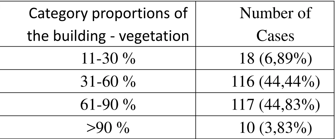
Table 1.
Number of dengue cases based on category
proportions of the building - vegetation
Category proportions of
the building - vegetation
Number of
Cases
11-30 %
18 (6,89%)
31-60 %
116 (44,44%)
61-90 %
117 (44,83%)
>90 %
10 (3,83%)
•
Figure 1. Scatter plot
Pearson’s
Correlation
landcover
(percentage of
building towards vegetation) with DHF cases (p=0,000 and r=-0,815)
11- 30 31- 60 61- 90 > 90
[image:9.720.152.502.104.385.2]•
Incidence of dengue in the region quite a lot the building but with
vegetation.
•
The existence of vegetation serves to keep humid in the micro
environment (Ainy, 2012)
•
Other Researches
–
Sarfraz
et al
(2012) in Thailand
settlements around horticulture
related to house index (HI) in Mei (p=0,05) dan perennial vegetation
related to container index (CI) (p<0,05)
–
Vanwambeke
et al
(2006) in Thailand
the axistence of trees and
watery land is an important factor in the incidence of dengue in
Thailand
–
Cheong
et al
(2014),
•
The extensive settlement have a role in the incidence of DHF in endemic areas
of urban
•
The existing of horticulture have a role in the incidence of DHF in sub-urban
area
Conclusion
•
The percentage of building against vegetation
surrounding correlate with the incidence of
DHF with the pattern of the building the
References
• Ainy,C.N. Pengaruh Ruang Terbuka Hijau terhadap Iklim Mikro di Kawasan Kota Bogor. 2012. Skripsi. Departemen Arsitektur Lanskap. Fakultas Pertanian. Institut Pertanian Bogor.
• Cheong,YL., Leitão, PJ., Lakes,T. Assessment of land use factors associated with dengue cases in Malaysia using Boosted Regression Trees. Published by Elsevier Ltd 1877-5845/ 2014.
http://dx.doi.org/10.1016/j.sste.2014.05.002
• Cong, RG and Brady, M. The Interdependence between Rainfall and Temperature: Copula Analyses The Scientific World Journal Volume 2012 (2012), Article ID 405675, 11 pages
http://dx.doi.org/10.1100/2012/405675
• Ditjen PP&PL, Depkes RI, 2010. Demam Berdarah Dengue di Indonesia tahun 1968-2009. Buletin Jendela Epidemiologi. 2010 Agustus; 2.
• Maciel-de-Frietas, R. 2010. A Review on The Ecological Determinants of Aedes aegypti (Diptera: Culicidae) Vectorial Capacity. Oecologia Australis 14(3): 726-736, Setembro 2010;
doi:10.4257/oeco.2010.1403.08
• Pemkab. Sleman, 2006. Profil Kabupaten Sleman. Diakses 10 Juni 2013 dari
http://www.slemankab.go.id/profil-kabupaten-sleman/geografi/letak-dan-luas-wilayah
• Sarfraz, MS., Tripathi,NK., Tipdecho, T., Thongbu, T., Kerdthong, P and Souris, M. Analyzing the spatio-temporal relationship between dengue vector larval density and land-use using factor
analysis and spatial ring mapping. BMC Public Health 2012, 12:853 doi:10.1186/1471-2458-12-853.
Available online at: http://www.biomedcentral.com/1471-2458/12/853
• Umoh,AA., Akpan, AO and Jaco,BB., Rainfall and Relative Humidity Occurrence Patterns In Uyo Metropolis, Akwa Ibom State, South- South Nigeria. IOSR Journal of Engineering (IOSRJEN) e-ISSN: 2250-3021, p-ISSN: 2278-8719 Vol. 3, Issue 8 (August. 2013), ||V4|| PP 27-31. Available at
http://www.iosrjen.org/Papers/vol3_issue8%20%28part-4%29/E03842731.pdf