DOI: 10.12928/TELKOMNIKA.v14i3A.4389 161
Relative Position Error Analysis for Mars Probes
Shaowu Chen*, Gang Ji, Dezhen Xu, Haitao Li, Guangliang Dong
Beijing Institute of Tracking and Telecommunication Technology, Beijing City, 100094, P. R. China *Corresponding author, e-mail: [email protected]
Abstract
Abstract: The relative angular position error covariance model of two deep space probes is propagated based on the error covariance analysis method, and is used for the relative angular position error analysis for multiple deep space probes. The differential time delay model of Same Beam Interferometry (SBI) about the relative right ascension and relative declination of two deep space probes is established, and the information matrixes of two ground-based baseline differential time delay measurements are obtained. The relative angular position error covariance is established, and the influence of measurement error and measurement geometry on relative angular position error is analyzed. The results show that in appropriate measurement geometry the relative right ascension and relative declination error of Mars probe are in order of 0.1nrad when the measurement error is in order of pico-second.
Keywords: Mars exploration; same beam interferometry; covariance model; relative position error
Copyright © 2016 Universitas Ahmad Dahlan. All rights reserved.
1. Introduction
Mars is the planet in the solar system which is similar to the earth most, as the rotation and revolution features the same as earth, seasons alternating on Mars and the length of the Mars day almost as well as the earth; it is the focal point of countries in planet exploration. It is hoped that establishing the second homeland and finding the life outside the earth by Mars exploration and the researching on the magnetic field, the atmosphere and climate, environment, landscape and the trace of water disappear of Martian. Finding water on Mars and signs of life as well as the recycling of the Mars sample is the focus of the current Mars exploration.
There are two major ways for human in Mars exploration, which are the orbit exploration and landing exploration. In the early time, there were the Ма series Mars probe of former Soviet Union and the Mariner and Viking series Mars probe of America. Then the Mars Global Surveyor (MGS) and Mars Odyssey of NASA and the Mars Express of ESA were carried out, and many pictures were obtained, and these mars probes are still working in the mars orbit for Mars exploration. In 1997, the Sojourner rover carried by the Mars Pathfinder of NASA landed on the surface of Mars, and it is the first rover of the Mars. The Spirit and Opportunity of the Mars Exploration Rover (MER) carried successfully in 2003. In 2011, the Curiosity carried by the Mars Science Laboratory flied to the Mars, and in 2012 it landed on the Mars for science exploration. The moving distance and the life time and the science exploration ability of Curiosity must be stronger, and much progress will be got, all these will benefit the Mars sample return.
differential angle position of two probes in the plane of sky, it is of great significant in the relative position determination of mars probes. In this article, SBI is used to investigate the relative position accuracy of mars probe.
2. Error Covariance Analysis Method
Error covariance analysis theory is an important mathematical tool in studying the solvability of the solution parameters by using some observation methods and investigating the influence of the error of target parameter on the solution accuracy. The theory is used in the studying of space geodesy and precise orbit determination by D.B. Tapley, and it is widely used in orbit determination accuracy analysis of probe [3]. The error covariance analysis method is adopted in the paper to analysis the relationship between the relative position accuracy of probe on the Martine surface and the measurement error and measurement geometry, and to format the systematic error analysis theory and method.
In 1970s, Jet Propulsion Laboratory (JPL) of NASA obtained analytical method of calculating the orbit position error covariance of probe by simplify the measurement model of range and range rate [4]. According to the interplanetary cruise segment flight dynamics characteristics of probe, the method is improved by V.J. Ondrasik by one order approximation of the gravity model [5-7]. S.W. Thurman analyzed the influence of measurement error of delta differential one way range (DOR) on the error of right ascension and declination of probe after
DOR and DOD are applied in space mission [7, 8]. J.A. Estefan improves the method by further step by the more accuracy modeling of flight dynamics of probe and introducing the weight matrix [9-11]. All the studying above, the error analysis method are obtained based on the error covariance analysis theory, however, the shortcoming of this method when it is applied in the mars probe relative position error analysis are as follows: 1) the measurement are range, range rate and △DOR, the measurement of SBI does not contain; 2) the investigating parameters are the absolute position and velocity, the relative position of multiple probe are not considered [12, 13].
In this article, the measurement model of SBI is established based on the measurement model of Very Long Baseline Interferometry (VLBI), then the measurement model of SBI about the relative right ascension and relative declination of Mars Lander and Rover is propagated. The information matrix of the time delay measurements of two ground baselines and the state error equation is obtained according to the error covariance theory, and then the relative position error covariance model is established. The influence of measurement error and measurement geometry on relative position error is analyzed using the error covariance model.
3. Research Method
In this section, simplified model of SBI is obtained, and the derivation of differential time delay measurement on the relative right ascension and relative declination is propagated by using the simplified model of SBI, the information matrix of the measurements on relative right ascension and relative declination is derived. The error covariance model of relative right ascension and relative declination is established according to the error equation.
3.1. Simplify of the Measurement Model
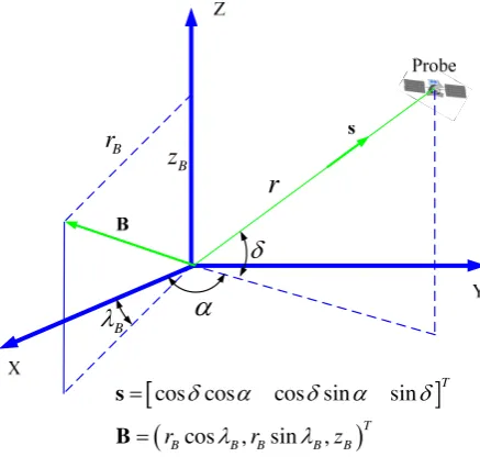
In order to facilitate the analysis, the J2000 geocentric celestial coordinate system is select as the reference coordinate system. The relationship between the differential time delay SBI measurement of two probes and state vector of two probes could be quickly built under the coordinate system.
The relationship between the position of the probe and the baseline in the J2000 geocentric celestial coordinate system is shown in Figure (1) The state vector of probe in spherical coordinates could be expressed as XPsph
r, ,
T, where r, and are thegeocentric distance, right ascension (RAsc) and declination (Dec) of the probe respectively. Assuming the state vector of baseline in cylindrical coordinates is expressed as
, ,
TB
cly rB B zB
X , where the component of the baseline which perpendicular to the earth's spin
is the right ascension of the baseline, then the state vector of baseline in Cartesian coordinate system could be expressed as XBcar
rBcosB,rBsinB,zB
T.
Bz
Br
r
B
cos cos cos sin sin
cos , sin ,
T
T
B B B B B
r r z
s
B
Figure 1. The state vector of probe and the baseline vector in J2000 geocentric celestial coordinate system
The time delay of VLBI is defined as the difference of the light time from the probe to two ground stations. As the distance from mars to ground station of earth is very long, so the measurement model of VLBI in form of distance D could be expressed as follow [7].
D B s
(1)
Where s is the geocentric unit direction vector of probe.
The geocentric unit direction vector of probe in the form of r, and could be expressed as cos cos cos sin sin , the measurement model of VLBI D could be expressed as
1
cos cos cos
sin cos sin sin cos cos sin
B B
B B B
B B B
D r
r z
r z
(2)
The differential time delay of SBI is defined as the difference of time delay of VLBI of two probes. As the measurement model of VLBI described above, the measurement model of SBI could be expressed as follow.
2 1 2 1
S D D B s B s
(3)
Where , is the time delay of two probes, , is the geocentric unit direction vector of two probes, and B is the same as mentioned above.
could be expressed as XRsph
r2, 2, 2
T. The measurement model of SBI could be expressed as
2 11 1 2 2
1 1 2 2
1 2
cos cos cos cos cos
sin cos sin cos sin
sin sin
B B
B B
B
S D D r r z (1)
Assuming 12 , 1 2
1 1 2 2
2 2 2 2
2 2 2
2
2 2 2 2
2 2 2 2
2
2 2 2 2
2 2 2
cos cos cos cos
= cos cos cos cos
cos sin =
cos sin cos cos
cos sin sin cos
sin sin cos sin
+ cos sin
O O O O O
2 (2)
As the distance from the center of the earth to mars lander and rover are longer than 5500000km, and the distance from mars lander to rover is about several kilometers. The relative RA and relative DEC are in the order of 10-7, the square of relative RA (RRAsc) and the relative DEC (RDec) are in the order of 10-14.Ignore the second order high order items, and then it is easy to get the follow expression.
1 1 2 2
2 2 2 2
cos cos cos cos
cos sin sin cos
(6)
Similarly
1 1 2 2
2 2 2 2
cos sin cos sin
cos cos sin sin
(7)
1 2 2
sin sin = cos
(8)
So the measurement model of SBI in form of relative RA and relative DEC could be expressed as follow
2 2 2 2
2 2 2 2
2
cos cos sin sin cos
sin cos cos sin sin
cos B B B B B r S r z (3)
3.2. Information Matrix
S S S X (4) Where
2 2 2 2 2 2 2 22 2 2
2 2 2
cos cos sin
sin cos cos
cos sin
cos sin cos
sin sin sin cos
sin cos cos
B B
B B
B B
B B
B B B
B B B
r S r r r S r z r z 。
The error equation is as follow
S
S
X X
(5)
The information matrix of single baseline SBI measurement could be written as
2 2 2 2 1 1 T S S S S S
S S S
S S S
I X X (6) Where 2 S
is the variance of the differential time delay error.
3.3. The Model of Error Covariance
When the SBI measurements are obtained on two ground baseline, the total information matrix is as follow
2 1 i S i
I I (7)According to the relationship between information matrix and error covariance matrix, the error covariance matrix of relative RA and DEC Cov in J2000 geocentric celestial coordinate system could be taken as
I (8)
4. Results and Analysis
4.1. Influence of Measurement Error on Relative Position Error
In the measurement process of SBI, the observation is affected by the error in process of the radio propagating and the signal processing, there would be several cycle ambiguity error in the differential time delay value, the error of SBI is changed accordingly, and this would lead to the change in the relative position error. As shown in Table 1, When the cycle ambiguity error from 0 to 2 the measurement error are 1ps, 0.5ns and 1ns.
The epoch of simulation is 22:30:00.000 (UTC), July 20th 2020, the position of lander in J2000 geocentric celestial coordinate system is [86364350.3 -45772716.3 38464949.0], the position of rover in J2000 geocentric celestial coordinate system is [86364341.2 -45772725.4 38464969.3]. Using the error covariance model, the relative position error covariances are calculated in different measurement of SBI. The error ellipse of relative RA and DEC are shown in Figure (2).
-0.14-0.07 0 0.07 0.14
-0.14
-0.07
0
0.07
0.14
-140 -70
0
70
140
[image:6.595.137.459.252.375.2]-140
-70
0
70
140
Figure 2. The relative position error in different measurement geometry
-0.1 -0.05
0
0.05 0.1
-0.2
-0.1
0
0.1
0.2
-0.1 -0.05
0
0.05 0.1
-0.2
-0.1
0
0.1
0.2
-0.1 -0.05
0
0.05 0.1
-0.2
-0.1
0
0.1
0.2
-0.2 -0.1
0
0.1
0.2
-0.2
-0.1
0
0.1
0.2
Figure 3. The relative position error in different measurement geometry
[image:6.595.146.419.422.635.2]4.2. Influence of Measurement Geometry on Relative Position Error
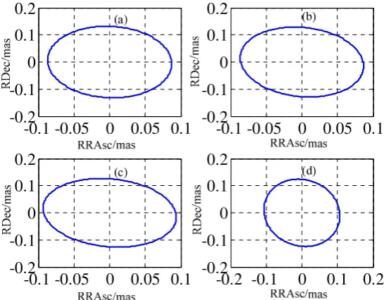
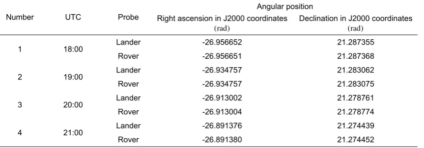
In order to analysis the Influence of measurement geometry on relative position error, 4 different observation epochs are chosen. The time and the position of lander and rover are shown in Table 2. All these positions are given by DE421 ephemeris. The error of differential time delay of SBI S is set at 1ps.
Table 1. The time delay error and Cycle ambiguity error
Cycle ambiguity error 0 1 2
Time delay error(ps) 1~2 450~500 1000
Table 2. The position of probes in J2000 geocentric celestial coordinate system at epoch
Number UTC Probe
Angular position Right ascension in J2000 coordinates
(rad)
Declination in J2000 coordinates (rad)
1 18:00 Lander -26.956652 21.287355
Rover -26.956651 21.287368
2 19:00 Lander -26.934757 21.283062
Rover -26.934757 21.283075
3 20:00 Lander -26.913002 21.278761
Rover -26.913004 21.278774
4 21:00 Lander -26.891376 21.274439
Rover -26.891380 21.274452
Note: the position of lander and rover are given by DE421.
The relative position errors are calculated by the information given in Table 2. The error ellipses are shown in Figure (3) (a)~(d) are the results of the 4 epochs which numbered 1, 2, 3 and 4. From the picture, it is easily to get the information as follow: 1) The error in Figure (3) (a)~(d) are 0.1m, 0.2m, 0.5m and 5m respectively, the position error is different when the epoch is different; 2) The direction and the oblateness of the error ellipse in Figure (3) (a)~(d) are different. It is believed that the measurement geometry have an impact on not only the size but also the direction of the position error. In the real process of orbit and position determination, the appropriate observation epoch should be chosen to assure that the error is smallest and the errors in all direction satisfy the requirement.
7. Conclusion
References
[1] Gregnanin M, Bertotti B, Chersich M. Same beam interferometry as a tool for the investigation of the lunar interior. Planetary and Space Science. 2012; 74(1): 194-201.
[2] Yan JG, Li F, Liu QH. Proposal of application of same beam VLBI measurements in precision orbit determination of lunar orbiter and return capsule and lunar gravity field simulation in Chang’E-3 mission. Advances in Space Research. 2011; 48(10): 1676-1681.
[3] Aluvalu RK, Kamliya V, Muddana L. HASBE access control model with Secure Key Distribution and Efficient Domain Hierarchy for cloud computing. International Journal of Electrical and Computer Engineering (IJECE). 2016; 6(2): 770-777.
[4] Curkendall DW, Mareynolds SR. A Simplified Approach for Determining the Information Content of Radio Tracking Data. Journal of Spacecraft. 1969; 6 (5): 520-525.
[5] Gang Li, Xiaofeng Zhao, Dianzhong Wen, Yang Yu. Research on Silicon-based Planar Spiral Inductance Coil Based on Microelectromechanical System. TELKOMNIKA (Telecommunication Computing Electronics and Control). 2015; 13(4): 1127-1132.
[6] Hamilton TW, Melbourne WG. Information content of a signle pass of Doppler data from a distant spacecraft. JPL Space Programs Summary. 2003; 37-39(3): 18-23.
[7] Thurman SW. Information Content of a Single Pass of Phase-Delay Data from a Short Baseline Connected Element Interferometer. TDA Progress Report 42-101. 1990: 26-38.
[8] Thurman SW. Deep-Space Navigation with Differenced Data Types Part I Differenced Range Information Content. Telecommunications & Data Acquisition Progress Report. 1990; 103.
[9] Yussuff AI, Khamis NHH. Determination of Melting Layer Boundaries and Attenuation Evaluation in Equatorial Malaysia at Ku-Band. Bulletin of Electrical Engineering and Informatics. 2014; 3(4): 293-302.
[10] Prestage JD, Weaver GL. Atomic Clocks and Oscillators for Deep-Space Navigation and Radio Science. Proceedings of the IEEE. 2007; 95(11): 2235-2247.
[11] Ulvestad JS, Thurman SW. Orbit-determination performance of Doppler data for interplanetary cruise trajectories. Part 1 Error analysis methodology. In its The Telecommunications and Data Acquisition Report. 1991: 31-48.
[12] Zemaili MN, Benabadji N, Hassini A. Design of a Low-cost and Compact Radiometer for Spectral Acquisition of Vegetation and Bare Soil. Bulletin of Electrical Engineering and Informatics. 2016; 5(2): 178-186.