DOI: 10.12928/TELKOMNIKA.v14i1.2497 507
Development of Coastal Radar Network at Sunda Strait
Mashury Wahab*, Deni Permana Kurniadi, T. T. Estu, D. Mahmudin, Yudi Yulius Maulana, Sulistyaningsih
Research Center for Electronics and Telecommunication-Indonesian Institute of Sciences (PPET-LIPI), Kampus LIPI, Jl. Sangkuriang Building 20, 4th floor, Cisitu, Bandung 40135, Indonesia
Phone: +62-2504660 Fax:+62-250-4659
*Corresponding author, e-mail: [email protected]
Abstract
In this paper, development on a coastal surveillance radar network, which is called ISRA (Indonesian Sea Radar), is presented. This radar network was developed for surveillance at the Sunda strait. The radar network monitors the sea traffics and activities at the Sunda strait, which an international shipping route. There were three radars installed for this network. All these radars in this research use FMCW (Frequency Modulated Continuous Wave) technology. This FMCW has an advantage of low power consumption, low cost of operational, longer life time and high reliability. Another important feature of this radar is the LPI (Low Probability of Intercept) capability, where the signal transmission of this radar cannot be easily detected by a radar detector (Electronic Support Measure) so that this radar can be used for a covert operation. Detected targets by radars are shown on the display and on the web based display for the radar network. These three radars on the remote sites can be monitored and controlled via an internet connection from the control room in our Bandung office, which is 300 KMs away. The results of this research and development show the Indonesian capability to build a complex system such as a chain of coastal surveillance radar network. The knowledge obtained from this research will be used to develop more advanced radars for different applications.
Keywords: coastal surveillance, FMCW technology, radar network, Sunda strait.
Copyright © 2016 Universitas Ahmad Dahlan. All rights reserved.
1. Introduction
Indonesia territory is surrounded by many countries including Singapore, Malaysia, Philippine, New Guinea and Australia. There are a lot of activities occurred in the Indonesian waters. The Sunda strait is an international waterway with the traffic of ships is very high. The security and transportation safety can be increased by the use of coastal radar along the Indonesian coastal lines and at the remote Island close to boundary regions.
Surveillance and navigation of Indonesian waters, which consist of more than 17.000 islands and 2/3 of Indonesia territory are seas, will be greatly helped by the use of marine radar. Medium and long range radars on coastal areas can be used to monitor the seas up to tens of nautical miles or until the border of economic exclusive zone. Fix and transportable coastal surveillance radars have been developed by the PPET-LIPI using FMCW technology and these are primary researches at the PPET-LIPI.
Radio Detecting and Ranging (Radar) is a technology that is very famous and reliable for identifying unknown objects.The Radar were developed and widely used in many applications such as for air surveilance, weather predictions, traffic controlling, military applications and so on [1, 2]. Recently, research on radar is still beeing conducted to improve its performance such as increasing the resolution of radar,the accuracy of radar, improve the performance of the radar antenna system and so on [3, 4]. Furthermore, the performance of the radar systems can be improved by adopting optical technology for data transfer and signal processing. Also the scanning system to improve the ability of the antenna system [5, 6].
facilitate the monitoring of vessel traffic in the Sunda Strait which is an international shipping line by placing the display and control of the radar systems of remote radar system by using the Internet network.
These radars was developed by use FMCW (Frequency Modulated Continuous Wave) technology. The FMCW technology have advantages of low power consumption, low cost of operational, longer life time and high reliability. Also this technology is hard detected by a radar detector (Electronic Support Measure) so that this radar can be used for a covert operation [6].
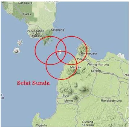
Figure 1. Locations of the Radar Network System at the Sunda Strait (Selat Sunda)
2. Basic Theory 2.1. Radar
Radar stands for radio detecting and ranging. Radar is a remote sensing system that is able to detect and determine the distance of an object using electromagnetic waves. Wavelength used is the radio wave spectrum, the width of the spectrum between 105 km to 0.1 cm (3 Hz - 300 GHz). Radar systems typically work at the microwave frequencies [7-16]. Radar system is divided into two main parts: the transmitter and receiver. Radar detection results will be displayed by the display unit that processes the signals received from the receiver to the information, in the form of images and data, making it easy to be analyzed by the user. Block diagram of the Frequency Modulated Continuous Wave (FMCW) radar system and its waveform, in general, can be seen in Figure 2.
2.2. FMCW (Frequency Modulated Continuous Wave) Radar
In the FMCW radar system, the energy is emitted along or nearly all the time. This means that at least 10% of the time spent by the signal to reach target. This is a very large percentage compared to that of normally used in radar pulses, where the energy emitted is usually less than 0.1% of the time. Thus, to obtain the same average received by the target, the pulse radar requires much higher transmitter output power than that of an FMCW radar transmitter [7-16].
2.3. Computation of Distance to Horizon
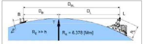
The radar range distance is also determined by the height of radar antenna position to sea level, the height of the target in the distance and also the curvature of the earth factor. Range distance is called distance to the horizon. Geometrical horizon distance can be seen in Figure 3.
Figure 3. Based on the theory of distance to horison formula is as follows [1]:
~ . (1)
The general specifications for the coastal surveillance radar can be described as follows [4], [8-9]:
1. Transmitter:
a. Frequency: X-Band (9.3-9.5 GHz).
b. Ranges: 48 NM, 24 NM, 12 NM, 6 NM, 3 NM, 1.5 NM.
a. Main frequency generator DRO (dielectric resonant oscillator). b. FM – Modulation.
c. Linear saw-tooth by using DDS (direct digital synthesizer). d. Sweep (Sweep Repetition Frequency): 1.5 KHz.
e. Fixed sweep time of 0.66 mS.
f. Frekuensi Sweep: 2MHz, 4MHz, 8MHz, 16 MHz, 32 MHz. 4. Antenna:
a. Microstrip Patch array with gain ~ 30 dB.
b. Dual antenna configuration for transmit and receive. c. Azimuth range: 180 degree
d. Elevation range: -5 degree up to 10 degree e. Beamwidth: < 1 degree.
f. Vertical beamwidth: ~10 degree. 5. Software : IMO Standard + ARPA+ ECDIS 6. Features of the coastal Radar
a. Low transmit power (<= 10 W)
b. Low Probability of Intercept (LPI) Radar c. No interference to other Radars
d. Target tracking e. Doppler capability
f. Able to be integrated into a Radar network
4. Development of the ISRA Radar Network
Three coastal surveillance radars have been installed at the Sunda strait. The location was chosen because there are a lot of sea traffics, where Sunda strait is one of the international routes in Indonesia and there are busy connecting transportations between Java and Sumatra islands. These three locations can be reached by land transportation from our office PPET-LIPI in Bandung with a distance of about 300 KMs. The three locations are Anyer, Merak and Lampung Selatan. These three radars can be connected and monitored remotely via internet connection from the office in Bandung. The following figures show the installed radar network.
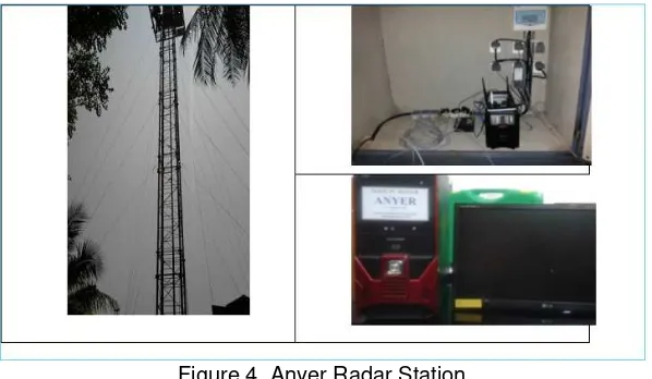
Figure 1 shows the locations of these three radars that close to the Sunda strait. The coverage of these radars is like a triangle where one point at the southern part of Lampung province, the other two points is located at the northern part of Banten province. It is expected that these radar network can monitors the sea traffic along the Sunda strait, which is an international route. Anyer radar station is depicted on Figure 4.
Figure 4. Anyer Radar Station
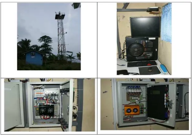
where this site was established in 2010. The radar at this Merak site has been running since 2011 for the purpose of radar running test and field test. This Merak site is in a straight line from the Lampung Selatan without any obstructions. While from the Anyer site to the Lampung Selatan site, there are a few small islands that can obstruct the coverage. The Merak radar station is shown on Figure 6.
Figure 5. Lampung Selatan Radar Station
Figure 6. Merak Radar Station
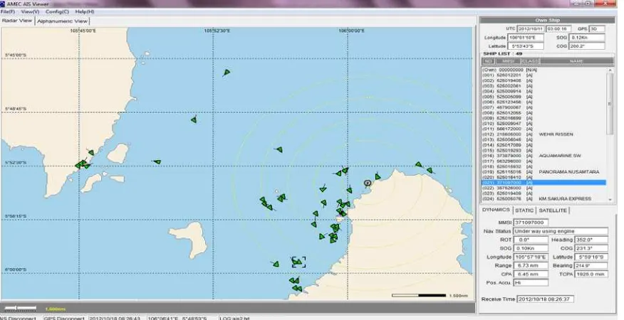
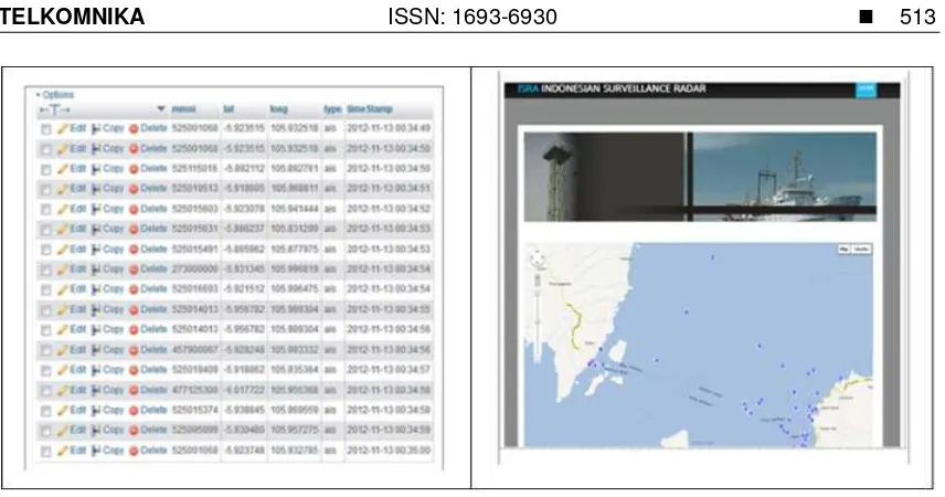
Connection of these three radar sites is provided by an internet connection where data from each site can be sent to a repository (cloud). The data link is also used to control the radars by the control room in our office which is located about 300 Kms away from these sites. Data will be stored to a database. Figure 9 depicts an example of data base and web based display of data collected from the radar network. The detected targets will be plotted on the display overlaid with the geographical map of the radar network locations. This radar network display can be accessed any where via an internet connection.
Figure 7. Example of Radar Display and control system at the Radar Network
Figure 9. Database dan web display for the Radar Network
5. Results and Discussion
Development of coastal surveillance Radar network has been presented. There are three Radars installed for this network at the Sunda Strait. The locations for the network are in Anyer, Merak and Lampung Selatan. Based on Equation (1), the height of Radar tower in Anyer is 10 meter so that the distance to horizon is about 11 KMs. While, the height of tower in Merak and Lampung Selatan is 15 meter with a distance to horizon is about 14 KMs. The distance from one end of the Java Island to the Sumatra Island for the ferry crossing is about 25 KMs. Thus, the coverage of these three Radars is enough to cover the area within the ferry crossing and the international route. Data collection and testing are still ongoing in order to improve the Radar performance and to monitor the traffic.
Some features of this radar network have been presented. The radar has a facility to control the transmitted power, to monitor the environment, and to detect failing components and modules. Radar display shows that some detected targets can be captured by the radar. Results of radar detection depend on the traffic intensity and weather. At night, the traffic intensity increases. The radar facility is equipped with the AIS in order to provide additional information on ships passing through this Sunda strait. The radars are connected via an internet connection where data are collected and stored to a database. The radars also can be controlled via this internet connection. The results of detection of this radar network is displayed on the web so that it can be accessed anywhere.
6. Conclusion
Acknowledgements
The funding for this research comes from the internal research funding of the PPET-LIPI. We thank to all parties including ISRA radar team that help in completing this research.
References
[1] MI Skolnik. Radar Handbook. McGraw-Hill. 1990. [2] G Kouemou. Radar Technology. India: In-the. 2009.
[3] Rika Sustika, Joko Suryana. Nonlinear Filtering with IMM Algorithm for Coastal Radar Target Tracking System. TELKOMNIKA Journal of Electrical Engineering. 2015; 13(1): 211-210.
[4] Sigurd Huber, Marwan Younis, Gerhard Krieger, Alberto Moriera. A Dual-focus Reflector Antenna for Spaceborne SAR Systems with Digital Beamforming. IEEE Transctions on Antenna and Propagation.
2013; 61(3): 1461-1465.
[5] Yusuf Nur Wijayanto, Dadin Mahmudin, Pamungkas Daud. Proposal of Fiber-Remoted Radar
Systems. International Conference on Radar, Antenna, Microwave, Electronics and
Telecommunications (ICRAMET). Bali, Indonesia. 2012.
[6] Dadin Mahmudin, Yudu Yuliyus, Folin O, Pamungkas Daud, Yusuf Nur Wijayanto. Photonic
Beam-Former Based on Micro-ring Resonator for Phased Array Antenna in Radar Applications. The 7th
National Radar Seminar and the 2nd International Conference on Radar, Antenna, Microwave, Electronics and Telecommunications (ICRAMET) 2013. 2013.
[7] A Stove. Linear FMCW Radar Techniques. IEE Proceedings for Radar and Signal Processing. 1992; 139(5): 343-350.
[8] Ligthart LP. International Research Centre for Telecommunications-transmission and Radar. TU Delft. Short Course on Radar Technologies. 2005.
[9] Wahab M, Daud P. Image Processing Algorithm for FM-CW Radar. TSSA/WSSA Conference ITB. Bandung. 2006.
[10] Wahab M, Daud P, Wahyu Y, Wijayanto YN. Radar Trainer System for LIPI FM-CW Radar Network.
ICICI. Bandung. 2007.
[11] Wahab M. Building a Radar from the Scratch: ISRA LIPI Radar experience. International Conference ICTEL. Bandung. 2009.
[12] Wahab M. Design and Simulation of High Performance Low Noise Amplifier for FM-CW Radar.
Journal of Electronics and Telecommunications of PPET-LIPI. Bandung. 2009.
[13] Wahyu Y, Oktafiani F, Saputera YP, Wahab M. Perancangan Antena Array Microstrip Planar Untuk
Radar S-Band. Prosiding Seminar Nasional Microwave Antena & Propagasi SMAP 2012. UI. Depok.
2012.
[14] Wahab M, Wahyu Y, Sulistyaningsih, Susanti ND. Penelitian dan Pengembangan Radar Pengawas
Pantai ISRA Generasi IV. Prosiding Seminar Ilmu Pengetahuan Teknik 2012. Bandung. 2012.
[15] Wahab M, Wahyu Y, Oktafiani F, Saputera YP. Design and Development of Microstrip Planar
Antenna for S-Band Radar. 3rd Makassar International Conference on Electrical Engineering and
Informatics (MICEEI). 2012.
[16] Kurniawan D, Adhi P, Satyawan AS, Syamsu I, Praludi T. Object Detector on Coastal Surveillance Radar Using Two-Dimensional Order-Statistic Constant-False Alarm Rate Algoritm. TELKOMNIKA