RAIN RATE ATTENUATION PREDICTION MODEL AT 12 GHz IN MELAKA
MOHD FIRDAUS B MOHAMAD SOBIRON
MOHD FIRDAUS B MOHAMAD SOBIRON
This report is submitted in partial fulfillment of the requirements for the award of Bachelor of Electronic Engineering (Computer Engineering) With Honours
Faculty of Electronic and Computer Engineering Universiti Teknikal Malaysia Melaka
UNIVERSTI TEKNIKAL MALAYSIA MELAKA
FAKULTI KEJURUTERAAN ELEKTRONIK DAN KEJURUTERAAN KOMPUTER
BORANG PENGESAHAN STATUS LAPORAN
PROJEK SARJANA MUDA II
Tajuk Projek :
RAIN RATE ATTENUATION PREDICTION MODEL AT
12 GHz IN MELAKA
Sesi
Pengajian : 2006/2009
Saya MOHD FIRDAUS B MOHAMAD SOBIRON
mengaku membenarkan Laporan Projek Sarjana Muda ini disimpan di Perpustakaan dengan syarat-syarat kegunaan seperti berikut:
1. Laporan adalah hakmilik Universiti Teknikal Malaysia Melaka.
2. Perpustakaan dibenarkan membuat salinan untuk tujuan pengajian sahaja.
3. Perpustakaan dibenarkan membuat salinan laporan ini sebagai bahan pertukaran antara institusi
pengajian tinggi.
4. Sila tandakan ( √ ) :
SULIT*
(Mengandungi maklumat yang berdarjah keselamatan atau kepentingan Malaysia seperti yang termaktub di dalam AKTA RAHSIA RASMI 1972)
TERHAD* (Mengandungi maklumat terhad yang telah ditentukan oleh
organisasi/badan di mana penyelidikan dijalankan)
TIDAK TERHAD
Disahkan oleh:
__________________________ ___________________________________ (TANDATANGAN PENULIS) (COP DAN TANDATANGAN PENYELIA)
Alamat Tetap: No. 74 Taman Harmoni 45400 Sekinchan Selangor
“I hereby declare that this report is the result of my own work except for quotes as cited in the reference”
Signature : ………
iii
“I hereby declare that I have read this report and in my opinion this report is sufficient in terms scope and quality for the award of Bachelor of Electronic Engineering
(Computer Engineering) With Honours”
Signature : ……….
DEDICATIONS
To
v
ACKNOWLEDGEMENTS
ABSTRACT
vii
ABSTRAK
Kajian thesis ini adalah mengenai ramalan rosotan isyarat berdasarkan nilai kadar hujan di kawasan Melaka pada frekuensi 12 GHz. Data – data lapangan diperolehi daripada Jabatan Meteorlogi Malaysia. Melalui graf kadar hujan ini, kadar hujan pada 0.01% adalah sebanyak 150 mm/jam. Jumlah pengecilan isyarat, dan jarak berkesan dikira menggunakan formula di dalam ITU-R Recommendation
P.618-9. Jumlah pengecilan isyarat adalah sebanyak 78.964 dB pada jarak berkesan
CONTENTS
CHAP TITLE PAGES
PROJECT TITLE i
DECLARATION 1 ii
DECLARATION 2 iii
DEDICATION iv
ACKNOWLEDGEMENT v
ABSTRACT vi
CONTENT viii
TABLE LIST xi
FIGURE LIST xii
ABBREVIATIONS LIST xiii
I INTRODUCTION
1.1 Project Background 1
1.2 Scope of Work 2
1.3 Project Objective 2
1.4 Project Methodology 2
1.5 Report Structure 3
II LITERATURE REVIEW
ix
2.2 Satellite Communication 5
2.2.1 Frequency Spectrum 5
2.2.2 C-Band 6
2.2.3 Ku-Band 6
2.2.4 Rainfall Impact on Satellite Link 7 2.3 Rainfall Structure and Types 8 2.3.1 Principal Sources of Rainfall Data 9
2.3.2 Malaysia Climate and Rainfall Distribution 10 2.4 Development of Rain Attenuation Studies 10
2.4.1 Rain Gauges 12
2.4.2 Rain Attenuation Modeling 14
2.4.3 ITU-R Global Rainfall Rate Model 14 2.4.4 Crane Global Rainfall Rate Model 15
2.4.5 Moupfouma Rainfall Rate Model 16 2.5 Specific Rain Attenuation Models 17
2.5.1 ITU-R Model for Specific Attenuation 18 2.5.2 The Effective Path Length 21
2.5.3 Effective Terrestrial Path 22 2.5.4 Moupfouma Reduction Factor Model 22 2.5.5 CETUC Reduction Factor Model 23
2.5.6 Garcia Reduction Factor Model 24
2.6 Exceedence Probability 24
2.7 Summary 25
III RESEARCH METHODOLOGY
3.1 Introduction 27
3.2 Implementing the Rain Rate Models 27
3.3 Measured Rain Rate 27
3.4 Specific Attenuation 28
IV RAIN ATTENUATION MODEL
4.1 Model Analysis
30
4.2 Rain Height 30
4.3 Slant Path Prediction Models 32 4.3.1 ITU-R Slant Path Prediction Model 32
V RESULTS ANS ANALYSIS
5.1 Introduction
37
5.2 Rain Rate Measurement 37
5.2.1 Monthly Cumulative Rainfall 38 5.2.2 Cumulative Distribution of Rain Rate 38
5.2.3 Comparison 41
5.3 Attenuation 42
5.3.1 Specific Attenuation 42
5.3.2 Attenuation Prediction 45
CONCLUSION AND FUTURE WORK 6.1 Conclusion
49
6.2 Future Work 50
xi
TABLE LIST
TABLE TITLE PAGES
2.1 Satellite Frequency Spectrum 6
2.2 ITU-R Annual Rate Cumulative Distribution for Reg.P 15 2.3 ITU-R Annual Rate Cumulative Distribution for Reg.H 16
5.1 Rain rates at 0.01% of time 39
FIGURE LIST
FIGURE TITLE PAGES
2.1 Hydrometeor effects over satellite path 8 2.2 Volume of spherical, uniformly distributed raindrops 11
2.3 Rain Gauges 13
2.4 The climatic zones and rainfall rate (ITU-R, 1997) 15
2.5 Regression coefficient αH 19
2.6 Regression coefficient kH 20
2.7 Regression coefficient αV 20
2.8 Regression coefficient kV 21
2.9 Example of Cumulative Distribution Graph 25
3.1 Flowchart of work methodology 29
3.2 Roadmap to calculate the attenuation and rain rate
prediction model based on ITU Recommendations 29
4.1 Yearly average isotherm height, ho, above mean sea level
in km. (ITU-R p.839-3) 31
4.2 Schematic presentation of an Earth-space path 33 5.1 Monthly Cumulative Rainfall – Courtesy from Malaysian
Meteorological Department
38
xiii
LIST OF ABBREVIATIONS
A Attenuation
A0.01 Attenuation at 0.01% of time
Am Measured attenuation Ap Predicted attenuation dB Decibel unite
f Frequency GHz Giga Hertz
ho Rain freezing height HR Rain height (km)
HS Height above mean sea level of the earth station (km). k, α Regression coefficients
km Kilometer
Leff Effective Path length
LG Horizontal projection of the slant path Lo Rain cell diameter
L path length
P (%) Percentage in time of the year
R(p) Rain rate at percentage in time of the year
r(P) Horizontal reduction factor of percentage in time of the year
r0.01 Horizontal reduction factor for 0.01% time of the year
R0.01 Rain rate at 0.01% of time of the year
v0.01 Vertical reduction factor for 0.01% time of the year
γR Specific attenuation θ Elevation Angle
1
CHAPTER I
INTRODUCTION
1.1 Project Background
Attenuation has been identified as a major problem for terrestrial and satellite links beyond 10GHz. High frequency, usually higher than 10GHz mostly suffer attenuation when facing a rainfall. The problem becomes more critical in tropical regions where there is high intensity rainfall a year. Most of terrestrial and satellite links designed for these regions must consider the attenuation given by each condition of rainfall, so that the communication is available all the time.[1]
Determine the specific attenuation for the specific rainfall rate is very important. It is impossible to specify the accurate value of attenuation for a certain rainfall rate; however a prediction is a best method to find the nearest and persistent attenuation value. Lots of research has been carried out in order to determine and predict the attenuation by considering the rainfall rate, elevation angel, effective slant path length, storm and also polarization used. Thus, each research contributed its own model for predicting the attenuation.[2]
1.2 Scopes of work
This project is limited to the following aspects:
1. Literature review.
Reviews on the existing research done on the rain rate attenuation prediction all over tropical regions. The prediction model used also being discussed.
2. Selection of appropriate data.
Data will be filtered where only data from tropical region measurement is valid.
3. Prediction.
The rain rate attenuation will be predicted by using different models.
4. Comparison.
The rain rate attenuation produces by each model will be compared to standard ITU-R for validity and consistency.
1.3 Project Objectives
The objective of this project is to predict the rain rate attenuation of 12GHz in Melaka.
1.4 Project Methodology
3
All parameters involve in this project will be analyzed. Also take into account is the standard which becomes a reference for those who designed any satellite link.
The measured field data is very important in order to predict attenuation model. Due to lack of facilities and equipment, the measured data is obtained from Malaysian Meteorological Department. The location of interest is at Melaka.
The raw data need to be processed into the simple form. Study about cumulative distribution graph is necessary as it could represent the data very well. All the parameters required for the next step can be extracted through this graph. The percentage of interest will give the intensity of the rain rate. The graph plotted from measurement data is compared to the famous model such as ITU-R, Crane and Moupfuma model.
The specific attenuation and predicted attenuation are calculated by using software EXCEl, Matlab and Matcad as they can provide better statistical analysis. The attenuation prediction is plotted in order to show the prediction model.
1.5 Report Structure
This report is organized in 6 chapters. The first chapter gives the brief introduction of attenuation in K-Band.
Chapter II : Covers the literature review
Chapter III : Covers design methodology
Chapter IV : Covers the rain rate attenuation modeling
Chapter V : Covers result and analysis
CHAPTER II
LITERATURE REVIEW
2.1 Introduction
Literature Review is important in each project as a base for gathering information necessary to complete the project. All information is gathered from various sources such as:-
1. Journal 2. Books
3. Conference Transcript 4. Thesis
5. Patent 6. Website
5
2.2 Satellite Communication
Satellite Communication system is basically an electronic communication package placed in orbit, whose prime objective is to assist communication transmission of information from one point to another through space [1]. Satellite system offer data transmission services such as carrying large size of voice and video, which is the back bone for telecommunication system. In addition, this satellite system provide coverage instantaneously infrastructure especially in underserved areas.
The satellite systems become popular in Malaysia when MEASAT Satellite Systems Sdn.Bhd. through its MEASAT Broadcast Network Systems Sdn.Bhd. had launched the Malaysian first DTH system. A DTH stands for Direct-To-Home where the reception of satellite programs is the personal dish in an individual home. The DTH system uses the Ku-Band Spectrum to operate which is around 12 GHz.
2.2.1 Frequency Spectrum
According to Goldhirsh [4], the lower band is in frequency, the better the propagation characteristic is available, and for the higher the band, the more bandwidth that is available. Therefore, the competition is keen for this spectrum due to its propagation characteristics.
C-Band 4-8 (GHz)
X-Band 8-12 (GHz)
Ku-Band 12-18 (GHz)
K-Band 12-27 (GHz)
Ka-Band 27-40GHz)
V-Band 40-60 (GHz)
[image:22.612.125.525.65.266.2]Millimeter 40-300 (GHz)
Table 2.1 Satellite Frequency Spectrum
2.2.2 C-Band
The frequency range allocated for C-Band is 3.7GHz – 6.425GHz. This range represents two usages where one half for grounded-to-space links (Uplink) and another half for space-to-ground links (Downlink) as shown: [3]
C-Band Uplink Frequencies: 5.925GHz – 6.425GHz [3] C-Band Downlink Frequencies: 3.7GHz – 4.2GHz [3]
2.2.3 Ku-Band
The frequency range allocated for Ku-Band is 11.7GHz – 14. 5GHz. This range represents two usages where one half for grounded-to-space links (Uplink) and another half for space-to-ground links (Downlink) as shown: [3]
7
This band widely used in telecommunication especially for satellite backhauls from remote area back to television network. The band is split into multiple segments that vary by geographical region by International Telecommunication Union (ITU).
2.2.4 Rainfall Impact on Satellite Link
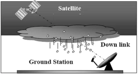
Satellite signal propagation above 10 GHz over an atmosphere is a subject of impairs and phenomenon such as, gaseous attenuation, cloud and fog attenuation, and rain attenuation [3]. All of these influences have to be understood so that these band channels can be used for high quality satellite services. Moreover, this influences of the impairment become greater as the microwave propagation frequency increasing.
Hydrometeors in the form of rainfall dominate the influences of the atmosphere on the satellite transmission [3]. The problem getting worst for system operating in tropical regions, where rainfall rate can be adversely affect the satellite link.
Rain can cause uncontrolled variations in signal amplitude, phase, polarization, and angle arrival, which result in a reduction in the quality of analog transmission and an increase in the error rate of digital transmissions [3].
Figure 2.1 Hydrometeor effects over satellite path
2.3 Rainfall Structure and Types
In general, rain can be classified into four types, stratiform. convective, monsoon and tropical rainfalls. [5]
i. Stratiform
Characterized by medium and low intensity wit long duration in the mid-latitude regions, extending homogenous to several hundreds of kilometers horizontally, with vertical heights values follow from the 0°C isotherm heights. Stratiform rain results from the formation of small ice particles in the upper troposphere layers. As they fall, these particles join together to form bigger nuclei. The growing nuclei becoming unstable and as they pass through the melting layer turn into raindrops that fall down to earth surface.
ii. Convective