International Seminar “Green Technology, Social Work and Public Health for Development of Indonesia”
Ramada D’MA Hotel, Bangkok, 28-29 October 2011
Diurnal Cycle of Rainfall over Indonesia during ENSO Events as
Observed by TRMM Satellite
Andik Pribadi
1,2,*1Joint Graduate School of Energy and Environment, King Mongkut’s University of Technology Thonburi, Bangkok,
Thailand
2 Department of Civil and Environmental Engineering, Bogor Agricultural University, Bogor, Indonesia
Kampus IPB Darmaga Gedung FATETA PO Box 220 Bogor, Indonesia 16002
* E-mail: [email protected]
Abstract—The phase and amplitude of the diurnal cycle of rainfall over Indonesia during El Niño Southern Oscillation (ENSO) events have been investigated using Tropical Rainfall Measuring Mission (TRMM) satellite observation datasets (3B42). The warm ENSO event (El Niño) and the cool event (La Niña) were selected based on the Oceanic Niño Index (ONI) for the period of 2001–2010. Harmonic analysis was used to detect the spatial and temporal variability of the diurnal cycle of rainfall for each event, and F-test was used to compare the 3B42 data during both events. Based on the ONI values, the period of June 2009–May 2010 and July 2007–June 2008 were selected for the El Niño and La Niña event respectively. The harmonic analysis results show that the diurnal cycle of rainfall is dominantly exhibited over Indonesia during both events with 73% and 74% explained variance for the El Niño and La Niña event respectively. The spatial-temporal distributions of the diurnal cycle are apparently not changed during both events. In general, large amplitude of diurnal cycle is exhibited over land with afternoon peak [1800–2100 Local Solar Time (LST)] and small amplitude is exhibited over ocean with morning peak (0900–1200 LST). Whereas over coastal area, midnight-early morning peak (0000–0300 LST) is exhibited with moderate amplitude. F-test with 95% confidence level ensures that generally there is no significant different variation of diurnal cycle of rainfall over Indonesia during both ENSO events.
Keywords—diurnal cycle; rainfall; ENSO; TRMM; harmonic analysis
I. INTRODUCTION
The Indonesia maritime continent is a well-known heavy rainfall area. The intensive rainfall over this region is not only a prominent local phenomenon there but also affects the global scale atmospheric circulation. The seasonal to inter-annual variabilities of Indonesian rainfall are characterized mainly by the monsoon and the El Niño-Southern Oscillation (ENSO) [1]. Indonesia experiences two monsoons every year that are the wet monsoon from November until March and the dry monsoon from May until September. ENSO strongly affects the rainfall pattern in this area and its influence is interconnected with the monsoons [2]. During El Niño (La Niña) events or warm (cold) phases, this region experiences lower (higher) rainfall than in other years [3].
Many studies have been conducted to investigate the ENSO impacts on inter-annual rainfall variability over Indonesia such as Gutman et al. (2000) [3], Aldrian et al. (2003) [4] and Hamada et al. (2002) [5]. However, studies on the ENSO impacts on short-term rainfall variability, such as diurnal cycle are still very rare. The study of variability of rainfall over short time scales is important and has wide range of applications in meteorology, climatology and hydrology. Some of the applications are to compare predictions of atmospheric models to real world atmospheric behavior [6], to understand the physics of the atmosphere [7], to understand the mechanisms of local weather [8], etc.
This study, therefore, will investigate further on the diurnal cycle of rainfall over Indonesia during ENSO events (El Niño and La Niña) using the Tropical Rainfall Measuring Mission (TRMM) satellite observation dataset. With progress in satellite remote-sensing techniques of precipitation estimation, large scale patterns of rainfall can be monitored using rainfall estimates with improved accuracy and spatial/temporal resolutions. The TRMM satellite launched in 1997 has provided more than 12 years (January 1998 to present time) of precipitation rates distributed over tropical regions between 38S and 38N. With the launch of the first TRMM satellite, it has become
possible to obtain “physically direct” measurements of rainfall and its vertical structure on asynoptic hours of the day, and this capability has added a new dimension to the study of rainfall variability on shorter times scales. One of the highest priorities of TRMM is to understand the diurnal cycle of tropical rainfall and its variation in space [9].
The result of this study is expected to provide relevant information for better understanding on the characteristics of Indonesian climate, particularly on the diurnal cycle of rainfall during warm and cool ENSO events.
II. METHODS
This study is conducted based on the steps as follows: (1) Determination the warm (El Niño) and cool (La Niña) of ENSO events; (2) Obtaining the TRMM data and extraction for the study domain; (3) Analysis of diurnal cycle of rainfall during both events; (4) Application of F-test to compare the diurnal cycle between the El Niño and La Niña event.
A. Determination of the ENSO Events
The strongest El Niño and La Niña events were selected based on the Oceanic Niño Index (ONI) for the
International Seminar “Green Technology, Social Work and Public Health for Development of Indonesia”
Ramada D’MA Hotel, Bangkok, 28-29 October 2011
period of 2001–2010. The ONI has become the de-facto standard that the National Oceanic and Atmospheric Administration (NOAA) use for identifying ENSO events in the tropical Pacific. It is the running 3-month mean sea surface temperature (SST) anomaly for the Niño 3.4 region (5N-5S, 120-170W) based on the 1971–2000 base period [10]. The ONI data are available at the NOAA website.
B. Data Obtaining and Extraction
The 3B42 product of TRMM data was used for this study. It is the calibrated Infrared merged with TRMM and other satellite data. The temporal resolution is 3 hour and the spatial resolution is 0.25 0.25. TRMM 3B42 is
a ”best estimate” of precipitation that combines observations from several space-borne instruments, including the precipitation radar and microwave radiometer on board TRMM as well as infrared radiometers from other platforms [11]. The operational archiving and distribution to the public of all TRMM science data products is provided by the Goddard Earth Sciences Data and Information Services Center (GES DISC). The data can be freely downloaded from the GES DISC website. Since the TRMM data cover global area, we need to extract the data for our study domain, the Indonesia region (6N-11S, 95-141E). R programming language was used for this extraction purpose.
C. Analysis of Diurnal Cycle of Rainfall
Prior to diurnal cycle analysis, the TRMM data were converted first from Coordinated Universal Time (UTC) time unit, which is the original of the TRMM data, become Local Solar Time (LST). LST instead of UTC are used to give a clearer picture of the diurnal distribution of rainfall, because the diurnal variations of rainfall are mostly due to the atmospheric response to solar radiation forcing [12]. The UTC can be converted to LST based on the longitudinal distance between each grid point and 0°. Then piece-wise cubic hermit polynomial interpolation was applied to obtain the rainfall data at 3 hourly LST (0, 3, 6, 9, 12, 15, 18 and 21 LST) so that the data at each grid point represent its 3 hourly local solar time.
Then the harmonic analysis method was used to detect the diurnal cycle of rainfall for both ENSO events, as described in [13]. The mean 3-hourly rainfall data
y
at each grid point can be subjected to a harmonic analysis:
harmonic order,A
andB
are harmonic parameters. Since the number of our data in one period(
n
)
is equal to 8, weThe phase of the harmonics corresponds to the maximum time
tmax of the harmonics, that is:harmonics can be described as:
2S is the sample variance of the data series.
D. F-test
The statistical F-test was then applied to compare the data in each grid between the El Niño and La Niña events. We used 95% confidence level for this test.
III. RESULTS AND DISCUSSION A. The El Niño and La Niña Events
Figure 1. Oceanic Niño Index for the period of 2001–2010[10]
Based on Fig.1, we selected the strongest ENSO events for our study that is the period of June 2009–May 2010 as the El Niño event and July 2007–June 2008 as the La Niña event. The strength and the period of the two
International Seminar “Green Technology, Social Work and Public Health for Development of Indonesia”
Ramada D’MA Hotel, Bangkok, 28-29 October 2011
events are approximately the same, with the peak about 1.5 anomaly and lasted for 12 months.
B. The Diurnal Cycle of Rainfall over Indonesia
The diurnal cycle variations of rainfall have been analyzed using harmonic analysis method. In this study, we only deal with the first harmonics, since the period of our data is one day, thus the first harmonics will represent the diurnal cycle. The proportions of the variance accounted for by the first harmonics for each ENSO event are shown on Fig. 2. This result explain that the two events have dominant diurnal periodicity of rainfall with almost the same mean total variances of all grid in this region which are 73% and 74% for El Niño and La Niña event respectively. The two events also exhibit almost the same spatial variation of the diurnal cycle which generally more dominant over land than over ocean. The diurnal cycle is not dominant over some ocean parts, which are indicated by small proportion of variance, such as over Pacific Ocean, Banda Sea near Timor Island, South China Sea and Indian Ocean.
Figure 2. Proportions of the variance explained by the first harmonics for a) El Niño and b) La Niña event
The amplitudes of the first harmonics for each event are shown on Fig. 3. Here we found that the El Niño and La Niña event are have approximately the same amplitude of diurnal cycle in term of magnitude as well as the spatial distribution. It can be seen clearly that the amplitude over land are larger than over ocean. Over some land regions, the El Niño event has slightly larger amplitudes such as over Java Island, western part of Sumatra and Kalimantan Island, and central part of Sulawesi Island. The largest amplitude within this region is exhibited over Papua Island for both ENSO events.
The time variations of the peak rainfall associated with the phase of the first harmonics for the El Niño and La Niña events are shown on Fig. 4. Both ENSO events
exhibit almost the same pattern of time of the peak rainfall.
Figure 3. Amplitudes of the first harmonics for a) El Niño and b) La Niña event
Some exceptions are over central part of large islands (Kalimantan and Papua) which have midnight-early morning peak (0000–0300 LST). Over ocean, the diurnal cycle have morning peak (0900–1200 LST), while over coastal area, that is sea area adjacent to island, the diurnal cycle have midnight-early morning peak (0000–0300 LST).
Figure 4. Time variation of the peak rainfall associated with the phase of the first harmonics for a) El Niño and b) La Niña event
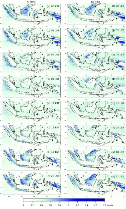
Fig. 5 shows the spatial-temporal variation of the diurnal cycle over Indonesia during both ENSO events based on the first harmonics.
International Seminar “Green Technology, Social Work and Public Health for Development of Indonesia”
Ramada D’MA Hotel, Bangkok, 28-29 October 2011
Figure 5. Spatial-temporal variation of the diurnal cycle of rainfall during (a-h) El Niño and (i-p) La Niña event
International Seminar “Green Technology, Social Work and Public Health for Development of Indonesia”
Ramada D’MA Hotel, Bangkok, 28-29 October 2011
The El Niño and La Niña event seem have almost the same distribution of 3-hourly rainfall over this region. It can be seen clearly that the islands have larger amplitude than ocean, as also shown on Fig. 3.
In general, the islands have the smallest rainfall during morning to noon time (0006-1200 LST). The rainfall start to become heavier at afternoon (1500 LST) and reach its peak around evening (2100 LST), then become lighter again toward morning time. Small (narrow) islands tend to have earlier peak rainfall and shorter period than large islands. For example over Java Island, the rainfall reach its peak at around 1800 LST and become lighter and disappear at around 0300 LST. While over Kalimantan Island, the peak rainfall occur at around 2100-0000 LST, and become lighter and disappear at around 0900 LST.
Over ocean regions, the diurnal cycles seem to have the opposite pattern than over islands. In general, the oceans have the smallest rainfall during evening (1800-2100 LST). It start to become heavier at early morning (0000-0300 LST), reach its peak in the morning (0600-0900 LST), then become lighter again toward afternoon time. In more detail, there is inhomogeneity pattern of diurnal cycle over small seas or straits (seas between large islands) and big ocean. Small seas tend to have more contrast (compare to islands) pattern than big ocean. For example, over Java Sea, the diurnal cycles get its peak when the rainfall over Java and Kalimantan Island are minimum, and vice versa. While over big oceans, such as Indian and Pacific Ocean, the patterns are not too contrasted.
The diurnal cycle variations during the ENSO events over Indonesia that we found in this study also have similar features with climatological pattern of diurnal cycle over this region as described by previous works such as [14], [15] and [16]. Analysis of the diurnal cycles of rainfall and winds indicates that the diurnal cycle variation over this region is predominantly caused by sea-breeze convergence over islands, reinforced by mountain– valley winds and further amplified by the cumulus merger processes [15].
The diurnal cycles of wind systems are important in the tropics where synoptic-scale pressure gradients are weak, but local pressure gradients caused by differential solar radiative heating between different surface types (e.g., land versus sea, highland versus lowland) are strong. In the case of land–sea breezes, the land heats up rather quickly during the day under the influence of solar radiation, while sea surfaces remain cooler because the thermal inertia of water is relatively large and because waves, turbulence, and penetration into deep water mix heat downward from surface water. As a result, convectional cells rise over land and sea breezes develop. At night, land cools off more rapidly than the ocean surface through longwave radiation loss, reversing the pressure gradients and forming land breezes.
Similarly, in the case of mountain–valley winds, mountain slopes heats up rapidly due to solar radiation during a sunny day. The free atmosphere over valleys or lowlands remains less affected by solar insolation and is thus cooler than the air over mountain slopes. The warmer and lighter air over mountain slopes rises, inducing
upslope valley winds and a compensating subsidence in the valley core. At night, air over mountain slopes cools off faster than that over lowlands, resulting in downslope mountain winds. Land breezes (mountain winds) are usually weaker than sea breezes (valley winds) because the land–sea (mountain–valley) temperature difference due to daytime heating is much larger than that due to nighttime cooling. In mountainous coastal regions, land– sea breezes and mountain–valley winds, being roughly in phase with each other, may combine to strengthen the diurnal cycle of winds and form extended land–sea breezes [17].
Cloud-merger processes, in which small cumulus clouds merge to form larger and deeper ones to amplify precipitation, contributed to most of the convective rainfall. Cumulus mergers also play a major role in the almost daily development of a family of tall cumulonimbus complexes [18].
The results of this study revealed that the selected ENSO events do not have much impact on diurnal cycle over Indonesia, in term of the phase. However, the magnitude of amplitude may be affected by these events, since it is well known that Indonesia region get less rainfall during El Niño event and get more rainfall during La Niña event.
C. Comparison of the Diurnal Cycle between the El Niño and the La Niña event
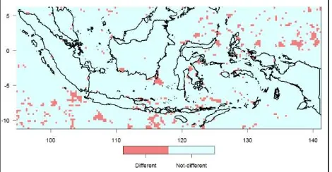
On our previous results, the diurnal cycle between the El Niño and La Niña event are apparently the same. The statistical F-test was then applied to compare the 3-hourly rainfall data in each grid between the two events using 95% confidence level ( = 0.05). The result of this comparison is shown on Fig. 6.
Figure 6. Comparison of the rainfall data between the El Niño and La Niña event using F-test ( = 0.05)
Obviously, the 3-hourly rainfall data between the two events are significantly not different over mostly part of the Indonesia region. There are some differences of the data such as over some parts of Pacific and Indian Ocean, but the number is very small. This result ensures that generally there is no significant different variation of diurnal cycle of rainfall over Indonesia during the El Niño and La Niña event.
However, this study only analyzes rainfall data at single event for each El Niño and La Niña condition. The features of the diurnal cycle probably will be different for another events in another years. Therefore, it needs series of ENSO events to investigate the long-term impact of
International Seminar “Green Technology, Social Work and Public Health for Development of Indonesia”
Ramada D’MA Hotel, Bangkok, 28-29 October 2011
ENSO on diurnal cycle of rainfall over Indonesia, which become our interest in our next study.
IV. CONCLUSION
In this study, we discovered the diurnal cycle of rainfall over Indonesia during El Niño event (June 2009– May 2010) and La Niña event (July 2007–June 2008) using TRMM data. Harmonic analysis that was applied in this study can successfully reveal the spatial and temporal variability of the diurnal cycle. The harmonic analysis results show that the diurnal cycle of rainfall is dominantly exhibited over Indonesia during both events with 73% and 74% explained variance for the El Niño and La Niña event respectively. In general, large amplitude of diurnal cycle is exhibited over land with afternoon peak (1800–2100 LST) and small amplitude is exhibited over ocean with morning peak (0900–1200 LST). Whereas over coastal area, midnight-early morning peak (0000– 0300 LST) is exhibited with moderate amplitude. In more detail, there are variations of the diurnal cycle features between small and large islands, and also between small and large oceans. F-test with 95% confidence level ensures that generally there is no significant different variation of diurnal cycle of rainfall over Indonesia during both ENSO events.
One of the major contributions of this study is its discovery on the diurnal cycle features over Indonesia during the ENSO events. However, since this study only analyzes rainfall data at single event for each El Niño and La Niña condition, it needs further study using series of ENSO events to investigate the long-term impact of ENSO on diurnal cycle of rainfall over Indonesia.
ACKNOWLEDGMENT
The author gratefully acknowledges the National Oceanic and Atmospheric Administration (NOAA) and the National Aeronautics and Space Administration (NASA) for providing the data.
REFERENCES
[1] Hendon, H.H. (2003) Indonesian Rainfall Variability: Impacts of ENSO and Local Air-Sea Interaction, Journal of Climate, 16, (11), pp. 1775-1790.
[2] Qian, J.-H., A.W. Robertson, and V. Moron Interactions among ENSO, the Monsoon, and Diurnal Cycle in Rainfall Variability over Java, Indonesia, Journal of the Atmospheric Sciences, 67, (11), pp. 3509-3524.
[3] Gutman, G., I. Csiszar, and P. Romanov (2000) Using NOAA/AVHRR Products to Monitor El Niño Impacts: Focus on
Indonesia in 1997-98, Bulletin of the American Meteorological Society, 81, (6), pp. 1189-1205.
[4] Aldrian, E., L. D. Gates, F. H. Widodo, 2003, Variability of Indonesian Rainfall and the Influence of ENSO and Resolution in ECHAM4 simulations and in the Reanalyses, MPI Report 346, 30pp, [Available from Max Planck-Institut für Meteorologie, Bundesstr. 55, D-20146, Hamburg, Germany.]
[5] Hamada, J.-I., et al. (2002) Spatial and Temporal Variations of the Rainy Season over Indonesia and their Link to ENSO, Journal of the Meteorological Society of Japan, 80, (2), pp. 285-310. [6] Bell, T.L. and N. Reid (1993) Detecting the Diurnal Cycle of
Rainfall Using Satellite Observations, Journal of Applied Meteorology, 32, (2), pp. 311-322.
[7] Kishtawal, C.M. and T.N. Krishnamurti (2001) Diurnal Variation of Summer Rainfall over Taiwan and Its Detection Using TRMM Observations, Journal of Applied Meteorology, 40, (3), pp. 331-344.
[8] Hamada, J.-I., et al. (2008) Differences of Rainfall Characteristics between Coastal and Interior Areas of Central Western Sumatera, Indonesia, Journal of the Meteorological Society of Japan, 86, (5), pp. 593-611.
[9] Simpson, J., R.F. Adler, and G.R. North (1988) A proposed tropical rainfall measuring mission (TRMM) satellite, Bulletin of the American Meteorological Society, 69, (3), pp. 278-295. [10] National Weather Service – National Oceanic and Atmospheric
Administration.
(http://www.cpc.ncep.noaa.gov/products/analysis_monitoring/ens ostuff/ensoyears.shtml). Accessed 17 August 2011.
[11] Huffman, G.J., et al. (2007) The TRMM Multisatellite Precipitation Analysis (TMPA): Quasi-Global, Multiyear, Combined-Sensor Precipitation Estimates at Fine Scales, Journal of Hydrometeorology, 8, (1), pp. 38-55.
[12] Dai, A. (2001) Global Precipitation and Thunderstorm Frequencies. Part II: Diurnal Variations, Journal of Climate, 14, (6), pp. 1112-1128.
[13] Wilks, D.S. (2006) Statistical Methods in the Atmospheric Sciences, Second Edition, International Geophysics Series, Academic Press, Burlington, MA, USA.
[14] Arakawa, O. and A. Kitoh (2005) Rainfall Diurnal Variation over the Indonesian Maritime Continent Simulated by 20 km-mesh GCM, SOLA, 1, pp. 109-112.
[15] Qian, J.-H. (2008) Why Precipitation Is Mostly Concentrated over Islands in the Maritime Continent, Journal of the Atmospheric Sciences, 65, (4), pp. 1428-1441.
[16] Hara, M., et al. (2009) Assessment of the Diurnal Cycle of Precipitation over the Maritime Continent Simulated by a 20 km Mesh GCM Using TRMM PR Data, Journal of the Meteorological Society of Japan, 87A, pp. 413-424.
[17] Hughes, M., A. Hall, and R. Fovell (2007) Dynamical controls on the diurnal cycle of temperature in complex topography, Climate Dynamics, 29, (2), pp. 277-292.
[18] Simpson, J., et al. (1993) Cumulus mergers in the maritime continent region, Meteorology and Atmospheric Physics, 51, (1), pp. 73-99.
![Figure 1. Oceanic Niño Index for the period of 2001–2010 [10]](https://thumb-ap.123doks.com/thumbv2/123dok/814882.376420/5.595.306.542.553.680/figure-oceanic-nino-index-period.webp)