PR()SIDING
ffi|ffiiffiffi*.,
Lffiuliffi*
@l[ffik--SIMPoSIT]M
ILMIAH
NASIONAL
IKATAN
ARSITEK
LANSEKAP
INDONESIA
201
0
Pemberdoyoon
Peron Serto
Profesi
Arsitek Lonskop
dolam
Mengotosi Masoloh
Kerusokon
Lingkungon
don
Bencono Alom
Melolui
Pendekoton
Konservosi
don
Penaioon
Ruong
Bogor,
I0
November
20t
0
dlterbllkon oleh: b€kerrosomo dengqn:
SAMBUTAN
KEruA
I.IMI.IM PN
TALI
SIMPOSIUM ITMIAH NASIONAT
IKATAN ARSITEK TANSEKAP INDONESIA
TAHUN 2O1O
Bismillahirahmanirahim
Assalamu'alaikum warahmatullah wabarakatuh Salam sejahtera untuk kita semua dan selamat pagi Yang terhormat
Direktur
DP2M,Direktorat Penelitiandan
Pengabdian kepada Masyarakat, Direktorat Jenderal Pendiciikan Tinggi - Kenrenterian Pendidikan lJasional RlRektor lnstitut Pertanian Bogor
para Dekan dan perwakilan dari
23
Universitasdi
lndonesia, baik Negeri maupun Swasta yang mempunyai program Pendidikan Arsitektur LanskapKetua Foi'um Pendidikan Arsitektur Lanskap lndonesia (FPALI)
para
pembicara,Prof Tong
lvlahnAhn dari
Seoul National Universitydan dari
Kementerian Lingkungan Hidup RlPara Undangan dan Peserta Simposium Nasionalyang berbahagia
pertama tama marilah ki[a bersama sama memanjatkan puji dan syukur kehadirat Allah SWT, Tuhan
yang Maha Esa, atas segaia karunia yanE dilimpahkan Nya kepada kita semua sehingga dapat hadir
ditempat yang sejuk ini, di IPB lnternational convention center dalam keadaan sehat walafiat'
pada kesempatan yang terhormat ini perkenankanlah saya menyampaikan apresiasiyang tinggi serta
ucapan terimakasih kepada Pemerintah lndonesia,dalam hal ini Direktorat Penelitian dan Pengabdian
kepada
Masyarakat, Kementerian PendidikanNasional
Rl,
yang
telah
memberikan untukpertamakalinya Bantuan Pengembangan Himpunan Profesi kepada
lkatan Arsitek
Lansekaplndonesia (iALl)
Bantuan pengembangan Himpunan Profesi ini kami peroleh dalam bentuk Hibah dengan mengajukan
proposal untuk menyelenggarakan Simposium llmiah Nasional, lkatan Arsitek Lansekap lndonesia (lALl) tahun 2010, dengan tema
"
Pemberdayaan Peran Serta Profesi Arsitektur Lansekap dalam mengatasi Masalah Kerusakan Lingkungan dan Bencana Alam Melalui Pendekatan Konservasidan
PenataanRuang".
Dituangkan dalam SURAT PERJANJIAN PENUGASAN, Dalam Rangka program Hibah Bantuan Pengembangan Himpunan Profesi, nomor 018/SP.SlP/DP2MN\|2010, pada tanggal 28 Juni 2010 dan berakhir pada tanggal 1 Desembet 2010.Simposium
llmiah
Nasional ini,dipandang pentinguntuk
diselenggarakanguna
menampung,menggalang Naskah llmiah, Konsep, Pemikiran-pemikiran dan Hasil Rekayasa serta Perencanaan dari para professional dalam bidang Arsitektur Lanskap di seluruh lndonesia, yang bertujuan untuk
meningkatkan kepedulian dan peran serta para peneliti, akademisi dan para profesional di bidang Arsitektur Lanskap dalam upaya mengatasi permasalahan kerusakan lingkungan dan bencana alam
melalui pendekatan konservasi dan penataan ruang.
Dalam Penyelenggaraan Simposium llmiah Nasional lkatan Arsitek Lansekap lndonesia tahun 2010 ini, kami bermitra dengan Departemen Arsitektur Lanskap dan Lingkungan Fakultas Pertanian, lnstitut
Pertanian Bogor. Untuk
itu
kami Pengurus Nasional lkatan Arsitek Lansekap lndonesia, sangat menghargai dan menyampaikan penghargaaan yang tinggi atas ker.jasama yang baik ini.Bapak, lbu dan peserta Simposium Nasioitalyang saya hormati,
Tema dari Simposium llmiah Nasional
ini
sangat tepat,yatu
penekanannya kepada pemberdayaanperan serta dari profesi Arsitektur Lanskap, maka kami sebagai insan Arsitek Lanskap lndonesia,
sebagai profesi yang turut beftanggung jawab terhadap pengelolaan sistem ruang luar, merasa perlu
untuk memberikan kontribusi pemikiran yang sampaisaat ini belum sepenuhnya dilkut sertakan dalam
tahap kebuakan-kebijakan dan selama ini pula lebih banyak mempunyai kesempatan pada tahap pelaksanaannya saja.
Keberaclaan Arsitek Lanskap masih dianggap sebagai pelengkap, hanya menjadi kebutuhan yang bersifat tersier dengan paradigma beautyfikasi sebagai konsep pengembangan bentang alamnya. Untuk itu melalui berbagai seminar, workshop dan simposium, karni berusaha merebut posisi profesi
ini guna lebih dapat memberikan sumbangan pemikiran secara universal, makna dari pentingnya
keberadaan suatu lansekap di lndonesia, pentingnya penataan ruang luar yang mewujudkan ruang-ruang
di
nusantarayang
nyaman, produktifdan
berkelanjutan sesuai yang diamanatkan olehlnternational Federation of Landscape Architecture ( IFLA ) dalam World Congress di Suzhcu - China
pada bulan Juli 2010, ciimana intinya adalah Arsitek Lanskap didorong untuk terlibat langsung cialarn
upaya pengurangan pernanasan global.
Melalui delegasi lALl, serta beberapa anggota lALl yang tuiut serta dalam kongres dunia ini, juga
telah
menyampaikan isu-isu strategis termasuk rnenyangkut keberadaan profesi lansekap dilndonesia.
Bapak lbu clan pesefia Simposium Nasionalyang saya hormati,
Didalam penyelenggaraan Simposium Nasional
ini, kami
membentuk gugus tugas termasukdidalamnya membentuk tim reviewer dan editor serta mengundang pembicara dari dalam dan luar
negeri. Makalah yang telah diterima adalah merupakan pemikiran alternatif untuk penyelesaian
masalah kerusakan lingkungan dan
budaya.
Para kontributor makalah terdiri dari para profesionaldan akademisi, termasukjuga yang sedang menyelesaikan program magister dan program doktor,
yang berasal dari komunitas dalam organisasi institusi pendidikan tinggi bidang Arsitektur Lanskap
yang
tergabung dalam Forum Pendidikan Arsitektur Lansekap lndonesia (FPALI), maka pada kesempatanini
kami sangat menghargai upayadan
karyadari
seluruh kontributor yang telahmenyampaikan makalahnya. Atas kerjasama yang baik ini dan sesuai dengan waktu yang telah
ditentukan, maka
tim
Simposiurn Nasionalini
telah berhasil menjaring serta selanjutnya dapatmenyeleksi
58
Naskah llmiah yang layak diterbitkan pada berkala ilmiah pada tingkat nasional, internasional, atau beraspirasi internasional..Dengan adanya kerjasama berupa Penugasan dari DP2M Direktorat Pendidikan Tinggi Kementerian Pendidikan Nasional Rl kepada lkatan Arsitek Lansekap lndonesia, maka kami dari Asosiasi Profesi
menyatakan bahwa
ini
adalah momentum awal dari kiprah profesi Arsitek Lanskap untuk lebihmemberikan kontribusi kepada bangsa dan negara guna menjaga alam Nusantara "agar tidak salah urus" yang dapat mengakibatkan kerusakan alam yang akhirnya menjadi masalah bersama yang sulit dikendalikan, karena evaluasi lanskap harus dimulai dari aspek manusianya, sehingga definisi apapun
tentang lanskap harus sudah mencakup dimensi sosial didalamnya.
Kenyamanan suatu lingkungan selain dapat terjadi karena karakteristik ruang yang sudah ada "given",
tetapijuga harus tetap mengutamakan azas manfaat sepefti berguna, ekonomis, sehat, aman, serta bersinergi dengan aspek produktif dan pembangunan berkelanjutan.
Bapak lbu dan peserta Simposium yang saya hormati,
Demikianlah sambutan Simposiufi llmiah Nasi'onal lkatan Arsitek Lansekap lndonesia tahun 2010.
Semoga Simposiurn ini menjadi pemacu semangat bagi lALl -organisasi profesi kita- untuk dapat menyelenggarakan secara rutin kegiatan semacarn inipada tahun-tahun mendatang.
Sedikit catatan dari profesi:
Para arsitek lanskap hendaknya dapat menjadi
pionir
dalam upaya konservasi, preservasi danperencanaan sistematis dari pemanfaatan sumber daya alam, sehingga manusia dan karyanya dapat
dibawa pada keharmonisan dengan sistem alami. Rasa bahagia akan timbul dari kesederhanaan,
ambilsecukupnya dari alam, maka kita akan hidup damai, nyaman dan ceria.
Semoga Allah SWT, Tuhan Yang tviaha Esa Senantiasa memberikan bimbingan dan karunia kepada kita semua.
Wasalammuallaikum Warahmatullahi Wabarakatuh
Hengki Triyogo Heksanto
DAFTAR
ISI
SUB.TOPIK
1 :PERENCANAAN
DAN
PERANCANGAN
1.
Agung Yansusan Sudarwin, Nia Kurniasih Pontoh, Bagas Dwipantara PutraPrinsip Perancangan Ekologis Pada Ruang Terbuka Hijau Publik cii Taman Kota Tegalega Banduno
2.
Akhmad Arifin Hadi, Einar Kretzler, Dr. Barty Warren-KreEschmarCommunicating And Evaluating Landscape Design Concepts Online With A
Virtual Reality Landscape Model
3.
AzrarHadiPublic Participation ln Open Space lnspection
4.
Bambang Sulistyantara, Fitriyana Budiwatilnterfunction Of Green Open Space Pian As Eartquake Evacuation Camp at Padang City, West Sumaiera
5.
Bambang Sulistyantara, Muhammad RizkiPenyusunan Apiikasi Penyimpan Basis Data Pohon Berbasis Koneksi lnternet Dengan Studi Kasus Kota Jakana Barat (Trees Database Aplication
Construction Based on lnternet Connection ltiith Case Study Of West Jakarta, lndonesia)
6.
Bambang Sulistyantara, Prita lndah PratiwiLandscape Pianning of Tourisnr Destination anO
the
Formulation of Tourism Program Alternative at Graha Tirta, Jatiluhur, Purwakarta District, West Java7.
Edy Saputra YuTata HUau Hunian MultiMassa dan Dampaknya Terhadap Perilaku Gated
Community (Green Design of Multi Mass Housing and lmpact On The Behavior Cf lts Gated Community)
8.
FirmansyahPengembangan Metode Assessment Kualitas Visual Lansekap Kampus Di
lndonesia, Kasus: Kampus Ul Depok dan tTB Bandung (A Development Of
Landscape Visual Quality Assessment Method of Campus ln lndonesia, Case Study: Campus Of lndonesia University (Ul) at Depok, and Campus Of
Bandung lnstitut Of Technology (lTB) at Bandung)
9.
Fitri RahmafitriaAnalisis Bahaya Lanskap Berbasis Konservasi Dalam Perencanaan Wana Wisata Kawah Putih
-
Jawa Barat (Conservation Based Landscape Hazard Analysis ln Kawah Putih Forest Recreation-
West Java)10.
lqbal Muhammad, Afra DN Makalew, Vera D DamayantiPerencanaan Lanskap Jalur lnterpretasiWisata Sejarah Budaya Jalan Slamet Riyadi Kota Surakarta (Landscape Planning of Historical-Cultural Tourism lnterpretation Trail at Slamet Riyadi Street, Surakarta)
11.
Lis Noer Aini / Agus Nugroho Setiawan / Arif Muda RambePerencanaan Tata Hijau SungaiBerdasarkan Konsep Ekologi, Studi Kasus Sungai Code Kota Yogyakarta (Ecologigal Planning Concept of Code River Case in Yogyakarta)
12.
Ludfie HamdriPrasyarat (Keharusan) Minimal Ruang Terbuka Terhadap Pengembang Perumahan Sebagai Bagian Manajemen Peftumbuhan Perkotaan Yang Cepat Berkembang
Halaman
1
13
20
2Ll
33r'
q3
52
88
5
.r' ,tMoch Saepulloh, Siti NurisYah
Perencanaan Lanskap Kawasan Pasar Terapung Sungai Barito Banjarmasin Kalimantan Selatan Sebaqai Kawasan Wisata'Budaya (Landscape Planning of
Floating Market Area at Barito River, Banjarmasin, South Kalimantan as CulturalTorusim ar.ea)
Moharharadlsrok Nugroho, Yong Hoon Son
Study of Usage of Cig Park As An Useable, Enjoyable And Manageable Place (Case Study:i21th Century Park - Matsudo, Japan, And City Park -Malang, lndonesia)
Nanang SuGlldiat, lndung Sitti Fatimah
Perencariaari Lanskap Jalan Tol Kanci- Pejagan Pada
Oemardi
ain Landscape Consultant, Bogor (Landscape Planning of Kanci- Pejagan Tollroad ln Oemardi_Zain Landscape Consultant, Bogor)Rahman Andra Wijaya
Menuju Kualitas Lanskap Yang Lebih Baik Rahman Andra Wijaya
Landscape of a Settlement: A Tale of Newfounci Farm and Cringleford
Resa Maharani, Tati Budiarti
Studi Potensi Lanskap Perdesaan Untuk Pengembangan Agrowisata Berbasis
Ir4asyarakat Di Kecamatan Cigombong Kabupaten Bogor (Potencies Study of
Rural Landscape For Agrotourism Based on Community Development ln
Cigombong Resicient, Bogor)
Rezky Khrisrachmansyah
Penataan Kawasan Pemukiman Bantaran Sungai Perkotaan Berbasis Ecological Design Studi Kasus: Bantaran Sungai Ciliwung (Pulau Geulis) Kelurahan Babakan Pasar, Kota Bogor (Settlement Plan Of Urban River Bank Based On EcologicalDesign Case Study: Geulis lsland ln Ciliwung River,
Babakan Pasar Village, Bogor)
Siti Nurisyah, Lisa Anisa
Perencanaan Lanskap Riparian Sungai Martapura Untuk Meningkatkan
Kualitas Lingkungan Alami Kota Banjarmasin (Riparian Landscape Planning of Martapura River to lncrease the Banjarmasin City's Natural Environment
Quality)
Siti Nurul Rofiqo lrwan, Mukhlison, Nahda Kanara
Kajian Permasalahan Ruang Hijau Kota Yogyakarta Untuk Pengembangan Lanskap Hutan Kota Dan Urban Greenway (Analysis On Yogyakafta Green Space For Development Of Urban Forestry Landscape And Urban Green Way)
SitiZulfa Yuzni
Lake Toba Tourism Area Management Based On EcologicalApproaches Ugit Mulgiati, Nizar Nasrullah, Bambang Sulistyantara
Pengaruh Penutupan VegetasiTerhadap Kenyamanan Kota (The lmpact of Vegetation Converage to the City Amenity)
Wasissa Titi llhami, Siti Nurisyah
Perencanaan Lanskap Kawasan Wisata Pesisir Yang Berkelanjutan
Studi Kasus : Pesisir Teluk Pacitan, Jawa Timur
(Sustainable Landscape Planning For CoastalTourism Region, Case Study ln Pacitan Bay, East Java)
101
13.
108 14.
11
{5.
12
16.
.n
17.
18.
12
135
155
i80
19.
20.
21.
13
11
22.
23.
24.
PROSIDING SIMPOSIUM ILMIAH NASIONAL IALI 2O1O
SUB-TOPIK
2:KONSERYASI
LANSKAP,
LINGKUNGAN
&
BI,IDAYA
Halaman
25.
Agnes Kristandi, Nurhayati Hadi SusiloArifin
1Perencanaan Lanskap Kawasan Wisata Sejarah Perkampungan Portugis di
Kampung Tugu, Jakarta Utara (Landscape Planning'on HistoricalTourism of Portugis Residence at Kampung Tugu, North Jakarta)
26.
AiDariah
11Tindakan Konservasi Secara Vegetatif pada Lansekap Pertanian (Vegetative Conservation Measures At Agricultural Landscape)
27.
I G.A.A. Rai,Asmiwyati, .N. L.P.Darwini, lda Ayu Mayun, A.A. Sri PradnyaParamita
'18'
Pola Pekarangan Rumah Tradisional Bali Di Kota Denpasar (Study OfBalinese Traditional Homegarden ln Denpasar)
28.
Annisaa Elok Perrnatasaridan Aris Munandar 28 ldentifikasi Hubungan Perilaku Vandalisnre Dengan Setting Pada KebunRaya Cibodas, Kabupaten Cianjur (ldentification Of Relationship Between
Vandalism Behavior And Setti;rg ln The Botanical Garden At Cibodas, Cianjur)
29.
Aris Munandar, Kaswanto, HS Arifin, AndriantoKusumoarto
38 Pengembangan Metode Penilaian Elemen Keindahan Lanskap BerbasisLandform dan Landcover Untuk Pengelolaan Lanskap Berkelanjutan (Developing Assessment Method of Landform and Landcover Based Landscape Aesthetic Quality for Sustainabie Landscape Management)
30.
Bambang Sulistyantara, Aris Munandar, NorilMllankra
5,-Residential Landscape Analysis Based On Energy Conservation
31.
DhaniBlshak
50Rencana Program lnvestasijangka Menengah dan Pelestarian Warisan
Aiam Kota Sabang
32.
Eka Kurniawati, Siti Nurisyah, Fredian TonnyNasdian
1Strategi Pengembangan Ruang Terbuka berbasis Komunitas di Kecamatan
Pontianak Kota, Kalimantan Barat (Development Strategy for Community-Based Park in Pontianak Kota District, West Kalimantan)
33.
GunawanBudiyanto
1Teknologi Konservasi Lanskap Gumuk Pasir Pantai Parangtritis Bantul Diy (Conservation Technology Of Sand Dunes Landscape
ln
Parangtritis Beach Bantul DIY)34.
Moh. Sanjiva Refi Hsb, Nurhayati Hadi SusiloArifin
8Karakteristik Dan Faktor-Faktor Yang Mempengaruhi Lanskap Budaya Rumah Larik Limo Luhah Di Kota Sungai Penuh, Kerinci, Jambi
(Characteristics And Factors That Affecting Cultural Landscape Cf Rumah Larik Limo Luhah ln Sungai Penuh, Kerinci, Jambi)
35.
Mohammad Zaini Dahlan, Nurhayati Susilo HArifin
BPerencanaan Lanskap Kawasan Wisata Budaya Di Kampung Budaya Sindang Barang, Bogor (Pendekatan Community Based Planning) (Landscape Planning On CulturalTourism Of Kampung Budaya Sindang Barang, Bogor - Community Based Planning Approach)
36.
Muhammad lftironi, FathmyAzizah
103
r
Revitalisasi Kawasan AIun-Alun Kota Magelang Slogan Magelang Kota
"Harapan" Sebagai Konsep Perancangan (Magelang Town Square Revitalization Magelang City Slogan "Harapan" As A Design Concept)
Naniek Kohdrata, Putu Edhi Sutrisna
Konservasi Subak Anggabaya: Suatu Model Konservasi Lanskap Bali (The Conservation of Subak Anggabaya: A Conservation Model of Balinese Landscape)
Neneng L Nurida
Alley Cropping: Teknik Konservasj Vegetatif Untuk Lahan Kering Terdegradasi Mendukung Konservasi Lanskap Lahan Pertanian (Alley Cropping: Vegetative Conservation Technique For Degraded Upland To Support Landscape Ccnservation Of Agricultural Land)
Rustam Hakim Manan, Quintarina Uniaty
Pendekatan Konsep Eco-Development Pada Pengembangan Kawasan Pasca Pertambangan Timah
Sidik Haddy Tala'ohu, Deddy Erfandi, dan lshak Juarsah
Penataan Lahan Pasca Penambangan Batubara (Land Management Post
CoalMining)
Stephanus Hanny Rekyanto, Yanto Santosa, Syartinilia
Model Kesesuaian Habitat Potensial Banteng (Bos Javanicus) Di Taman Nasional Ujung Kulon dengan Menggunakan Regresi Logistik (Potential Habitat Suitability Model Fcr Banteng (Bos Javanicus) In Ujung Kulon National Park Using Logistic Regression)
Sumantris lndri, Aris Munandar
Evaluasi Perseptual Kualitas Estetika Dan Ekologi Kebun Raya Cibodas T. Vadari, A. Rachman
Aplikasi Geo-Splash Versi 1.0 Untuk Merancang Disain Teknik Konservasi
Tanah Di Lanskap DAS Kali Babon Taufan Madiasworo
Revitalisasi Kawasan Bersejarah Perkotaan dalam Perspektif Penataan Ruang, Studi Kasus ; Kampung Melayu Semarang (Revitalization Of Urban Heritage Area ln Spatial Planning Perspective, Case Study: Kampung Melayu Semarang)
Umi Haryati, TatiBudiarti dan Afra D Makalew
Rekomendasi Teknik Konservasi Tanah Dan Air Untuk Pelestarian Lanskap Pertanian Lahan Kering Di Das Bagian Hulu (Kasus Dataran Tinggi Gunung Salak, Das Cisadane) (Recomeridations Of Soilp.nd Water Conservation
Techniques For Sustainability
Of
Upland Farming Landscape ln Upper Watershed (CaseOf
Gunung Salak Highlands, Cisadane Watershed))SUB-TOPIK 3
:GREEN INFRASTRUCTTIRE
46.
Alinda F.M. Zain, Azhari Syarief, Soedodo HardjoamidjodjoDeteksi Penurunan Ruang Terbuka
Hijau
dan
Dampaknya Terhadap Peningkatan Kawasan Rawan Banjirdi
Kota Padang (Urban Green Space Detection and Flooding Prediction in Padang)47.
Bambang Sulistyantara, Esti BudiartiEvaluasi Kondisi Pohon Pada Beberapa Jalur Jalan Arteri Di Kota Jakarta
Pusat, Provinsi DKI Jakarta (Tree Condition Evaluation
Of
Some Arterial Roads At CentralJakarta City, Province of DKI Jakarta)49.
Djajeng Poedjowibowolnfrastruktur Limbah Terpadu Dalam Taman Lihgkungan permukiman (lntegrated Waste lnfrastructure in Environmental Settelement Park)
37. 110
183
Halaman
1
11
38.
12
135
39.
40.
41.
155 42.
43.
13
45.
Dini Rosmalia
Pengembangan Kawasan Berbasis Kondisi Fisik Lokal Studi Kasus Kawasap
Paninggahan, Solok, Sumatera Barat (Development Area Based
on
LocalPhysical Condition, Case Study Area Paninggahan, Solok, West Sumatera)
lwan lsmaun
Kajian Hidrologis Kawasan Parkir Timur Senayan
-
Jakarta Ninrvono JogaKota Lestari: lnfrastruktur Hljau Kota
Pangesti Nugrahani dan Endang Triwahyu Prasetyawati
Tanaman Semak Hias Lanskap Jalan Sebagai Fitoindikator Pencemaran Udara SO2 di Perkotaan
Siti Nurisyah, Jafar Shodiq
Perencanaan Kampung Berbasis Lingkungan (Ecovillage)
di
KawasanPenyangga
Taman Nasional
Ujung Kulon
Banten,
Kasus
KampungCimenteng, Desa Taman Jaya, Kecamatan SumLrr, Kabupaten Pandeglang,
Propinsi Banten (Ecoviiiage Landscape Planning
at
Buffer Areaof
Ujung Kulon National Park, Case studyat
Kampong- Cimenteng, TamanJayi
Village, Banten Province)
SUB-TOPIK
4
:GREEN
BLIIDING
54.
Bambang Deliyanto, Aris MunandarPerformansi Eco-Spatial
Behavior
Pada Penghunian Rumah Susun KotaBaru Bandar Kemayoran, Jakarta (Eco Spatial Behavior Performance Of Occupancy Settlement ln Kemayoran New Town Flats, Jakarta)
55.
Lestari Suryandari, Yodi DanusastroPeranan
Riset
Dan
Peningkatan Keterampilan Arsitek Lanskap DalamMenghadapi Penerapan Konsep Green Building (The Role of Research and Competency
of
Professional Landscape Architect Facing Application ofGreen Building Concept)
56.
Ning PurnomohadiCreating Herbal Medicine & Kitchen Garden ln and Around Settlement, ln A
'Green Building' Development Approach
57.
SitiSujatini, Euis Puspita DPeran Serta Arsitek Dalam Rangka Mengendalikan Kerusakan Lingkungan
(Arch itect's Com mitment t n O rdei To Coniot Environ mental Damagei)
25
30
51.
52.
53.
Halaman
1
12
ABSTRAK
KARYA
POSTER
1.
Dewi Rezalini Anwar, Sugiarto, Ray Agung SucikaTaman Pisang Wajah Baru Ruang Terbuka Kota yang Ekologis
2-
Dina safarinanugraha, Dwi setyanti, Hartono wijaya, Juniar Adi, MedriaShekar Rani, Moch. Rizki, Mohammad Tarmizibin Mohd.lsmail Tropical Plant conservation parks The
Buffer
oneof
Bogor Botanical Garden3.
Fitri RahmafitriaPerencanaan Tahura lr H Juanda Melalui Pendekatan Bahaya Lanskap dan
Preferensi Visual
4.
Padmana Grady prabasmaraConnectibility Green I nfrastructure As G reenways
5.
Putri Wulandart dan Aris MunandarDesain Penanaman Menuju Konsep Eco-City Di Klaster Pine Forest, Sentul,
city, Bo-gor (Planting Design towards Eco-city concepts in clutser pine
Forest Sentul City, Bogor)
6.
Rustam Hakim MananLansekap Desain Proposal Sekolah Taman Kanak-Kanak rjan Sekolah Dasar
7.
Rustam Hakim MananPerancangan Kawasan penerima pusat pemerintahan Kabupaten Tangerang-propinsi Banten
8.
Rustam Hakim MananPenghijauan Perkantoran Geostech BppT Serpong
9.
Siti Nurul Rofiqo lrwan dan KaharuddinStudi Kenyamanan Aktivitas di Hutan Kota Kampus Universitas Gadjah Mada
Studi Kasus: Klaster Agri Ugm
{0.
sugeng Triyadi S., lndra Budiman Syamwir, Andi Harapans.,
rsmair,Endang Ruhiyat 5
Pemanfaatan Potensi Lokal Dalam perancangan Kawasan Bekas Tambang Timah di Bangka Belitung
Halaman
1
INTERFUNCTION
PLAN
OF
OPEN
GREEN
SPACE AS EARTHQUAKE
EVACUATION CAMP
IN
PADANG,
PROVINCE OF WEST
SUMATERA
Fitriyana Budiwatil), Bambang Sulistyantara2)
1)Mahasiswa
Departemen Arsitektur Lanskap, Fakultas Pertanian, lnstitut pertanian Bogor
2)
Staf Pengajar Departemen Arsitektur Lanskap, Fakultas Pertanian, lnstitut pertanian Sigor ABSTRACT
lndonesia appears to be one of att the country that took ptace within the area of disaster. That's why the government should try to reduce the risk of all the dlsasfe/s threat. The ptan is being forwarded to discuss the
evacuation space. This plan could be realised by using the city's open green space as the evacuation space. The
open green space also has a function for recreation, so it will share comfoftables to the people around This
plan's practice is being done in Padang, Province of West Sumatera. The method that had been used for the research, is using surveying and data collection method within the job desk which mention the resources €nd activity closure The steps includes preparation. inventaritation, analysis, synthesis, and planning The practice is
based by the interfunction of the open green space concept by social closure The open green space is functioned as shelter when the earthquake occurs The result of the practice consists of landscape planning and
the programs that support it
Kelnruords: Disaster, Earthquake, Open Green Space, Evacuation
{
INTRODUCTION
Background
lndonesia
is
one country whichis
lo-cated
in
disaster-prone zones. Geologically lfdonesia lies between plate tectonics and the pathof
an.active volcano. Based on the datafrom
National lnstitute
for
DisasterMana-gement (BNPB), in 2008 lndonesia had 8 cases
of earth
uakes,
cases of floods, 1 case of volcanic eruption, and 22 cases of flooding andlandslides. The disaster are commonly cause
casualties
and
material
ca-sualties.As
adisaster-prone
country,
the
lndo-nesiangovernment should attempt to reduce the risk of disaster. Efforts to reduce the risk of disaster is
realized with the planning of eva-cuation sites.
On
30
September 200,
the city
of Padange
perienced the earth uake thatdes-troyed buildings and residentials. Currently, the
city
of
Padangis
undergoingthe
post-earth-uake
reconstructionand
rehabilitationpro-cesses. According
to
Joga
(200),
the
city should be rebuilt by allocating more open greenspace,
to
accommodatethe
needs
of protection, evacuation,or
survival
of
thedisaster.
Disaster mitigation efforts still need to
be
preparedto
minimize casualties. Societydirected .towards
the
placesthat
have beenprepared for evacuation, and the use of signs that can help in an emergency.
Therefore,
it
re
uiredan
urbanplan-ning with open green space area
as an
ele-24
suB-roplK iment
of
development that can be used as analternative evacuation area to self-rescue in the
event of an eafth uake disaster.
Objectives
This study aims to:
1.
Creating a open green space utilization plan as an eath uake evacuation area in padang.2.
Creating alternative evacuation area whenthe earth uake occurred
by
usinga
green open space.Benefits
Result is
e
pectedto
provide input for government of Padang and the parties relatedto
the structuring open green spacein
deve-lopment plans
of
the cityof
Padang after the earth uake disaster. Actual studies aree
pect-ed to provide benefits to the people of padang
and the environment around the city.
METHODOLOGY Location and Time
Study
for
planningthe
utilization of open green space as an evacuation area ofthe earth uake in Padang, West Sumatra province. Study sites located in the west of lndonesia, as shown in Figure 2.Data
open green space
is
an areaof
physical data (Table 3). These data consists of primary data obtained from field survey and secondary dataobtained
from
literature studies,and
other sources. The data is then grouped into commondata and socio-economic data (socio-economic
identity
of
the
population andthe
desire ofvisitors).
Table 1. Tvoes and Sources of Data
Jeais Detr Itrterpret$i dsta Sumb€r Ilrt
I
The data used
in
planningfor
urbh.,Figure 2 Location of the study (Source: Wikipedia, accessed on December 2 ,2OO )
The
time
of
study
sincethe
imPle-mentationof
the study until the making of re-ports on the results of study lastedfor
months(February 2O1O - July 2010).
Tools and Materials
Tools and materials used in this study consisted of:
1. Thematic Map of Padang
2.
Software ArcView
3.2,
Autocad
2010,Adobe Photoshop CS3
3.
Laptop, GPS, DigitalCameras. Study LimitationsThe location
of
this study was limitedonly
to
the
mainland cityof
Padang ande
-cluding small islands which included in the city of Padang, West Sumatra Province, The study
method used in this study is
a
survey methodand data collection which consists of resources
and activities approaches. Stages of the
plan-ning process, including preparation, inventory, analysis, synthesis and planning.
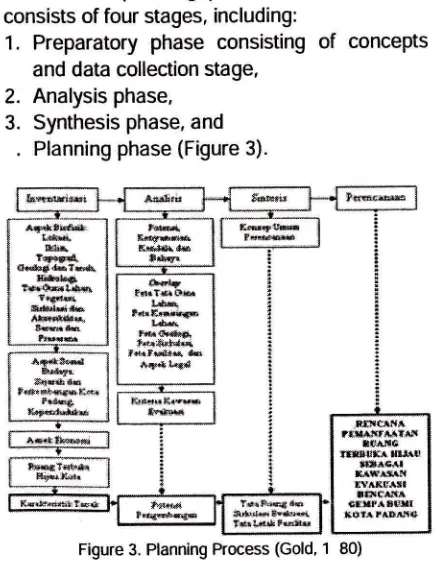
Planning Methods
The
planning processat
this
location consists of four stages, including:1.
Preparatory phase consistingof
concepts and data collection stage,2.
Analysis phase,3.
Synthesis phase, and.
Planning phase (Figure 3).D.ta UEum
. Id.k GeogEf s ds AdsiniMif kElq LE Bak @ak
Kot{ Kontudmkemiringulaha
. Dat.TopogEfi dmKmiringaq Cuahhujsetahdekseprm
. DaBlklie mgi[suhuudanBq{dq
.D,hcmt;sidmTan.l kelembabanrelatifudqJois
. nri v"".ii.i_ bah, Jenis dq pmebaBn biot4
:-. ,;:- , - -. Keadam hidrologi do dnims
. @B rumroF,
. M$EIPlatr Kola
Drti So.irt
:-'--:---'. . . ldmtits pmggh4 pmgelol4
' Dab KePmMuq m,sBkat di dalm dil skibr
. P-oki PelgEW (Pdlakq L*L*
"trti"i* y.ng
lciryinad ailalcuta**ij*o pmuarr
tms@iRTH
. BAPPEDA
. BPN
.BakMl
. Lape8pn
. Di6T.bR@g
do Tab Bangwan
Kob Padeg
o BPS
. Lapangd
GENERAL CONDITIONS
Geographical Location and Administration Area
Study of open green space planning as
an evacuation area was conducted in the city of Padang which is the capital of West Su-matra
/
Province. The city of Padang is located onthe
/
coast of western Sumatra island, with total area
of
km
area. From the vast territory ofmorethan
0 ,ie 3.3km
isahillYarea of protected forests, and the rest is an effectiveurban areas. Geographically, the city of Padang
is
locatedat
100 0505 east longitude-
1003
0
east longitude and00
00 latitude-01 08
35
latitude. This positionis
a
disaster-prone zone because
it
is
locatedin
between two tectonic plates and an active volcano track.Administratively, the city
of
Padang is divided into 11 Districts and 103 Villages.Pa-dang City has the following boundaries.
o The North adjacent to
the
Padang Pariaman District.o To the east adjacent to Solok District.
r To the south is bordered by the Pesisir
Sela-tan District.
.
To the west is bordered by the lndian Ocean.Climate
Rainfall annual average
of
Padang in200
amountedto 1
mm, with
averagerainfall
385
mm/month.The
highest rainfall*tfl&}rde.
tkfix
t{?id'
{..ro(t {& tb*t llt;cr.*i tffi{l#rtih* tl*rldi** tl*rttrS* *r*{i* ei*3* t*i*rtQffifie
,rt ct:l^
r*llijrffitirl
flMa
rtrtru*r $rl{.4
***is,ll g*ffit f,arixt*rl ttir(*is crtrpaSlllrr tuhrtGd+ Figure 3. Planning Process (Gold, 1 80)
[image:12.599.77.284.41.140.2] [image:12.599.322.537.195.334.2] [image:12.599.78.296.490.772.2]occurs in January
with
mm rainfall and thelowest in May with
1
mm rainfall.The average humidity in padang based
on
Padangin
Figures200
ranged bet-ween0
-8
. While the average wind speed was5.25 knots.
The
averageair
tem-perature of Padangis
highar
between23
-32 C
in
thedalrtime and at night is between
22
-ZB C. The average humidity in Padang pa-dang in Figures200
rangedbetween
0 -B
.Whilethe
average wind speed was 5.25 knots.
Topography
Padang city has
a
varied topography,which consists
of a
gently sloping plains andundulating hills that are steep.
Most
of the
ropographyof
the city of Padang hasa
high average landslope
0 West region close to the beach. This area hasrelatively flat topography. More to the east, the topography
of
the city
of
padangtend
in_creasingly bumpy.
Geology and SoilTypes
Geologically,
the
city
of
padang
isformed by the sediment surface, volcanic and intrusive rocks and sedimentary and
metamor-phic
rocks.There
are
areas
proneto
soilmovement. The region is situated on the east_
ern and southern city
of
padang. The regionprone
to
rock movementis
pauh District, Lu-buk Kilangan Districk, LuLu-buk Begalung District, and Bungus Teluk Kabung District.Land Use
The entire city of padang
is
kmwide,
or
1.
5
of thee
uivalent area of West Sumatra Province. From these wide, more than0 ie
3
.
3
km
is an area of protectedforest-covered hills, then the rest is the effective
urban area. Padang city has
a
coastline alongthe
B
km. Land use is very diverse in the city of Padang. ln general, the percentage of open green space in the city of padang is at 93.0DATAAND ANALYSIS Biophysical Aspects Climate
Average rainfall
of
padangin
200 amountedto 1
mm,with
average rainfall385 mm/month. The rainfall which is high
indi-cates the availability of water in the city of
pa-dang sufficient for plant availability. However, to
reduce evaporation in coastal areas,
it
should26
suB-roplK ibe planted with mangrove vegetation in coastal areas.
The city
of
padangin
general have a comfortable climatefor
human activity.lt
isseen from
the
data average humidityof
pa_dang based on Padang in Figures
200
rangedbetween
0 -B
,andaveragewindspeedwas
5.25 knots. Alternative planning may bedone
on
this
conditionis
the
provision of supporting facilities that drive human beings to be more productive in their activities.Brooks
(1 88)
statesthat the
use of vegetationwill
produce shadefor
users whomove in open areas. This can help lower the average air temperature which
is
high enoughin
Padang.The
average humidityin
padang basedon
Padangin
Figures200
rangeO/
between
0
-
I
.
While the average wind/
speed was 5.25 knots. On a scale of Beauford,
the winds are included in the category of weak
wind which
is
very
suitablefor
convenience.The wind also serves to lower the humidity, so
the
needfor
planningto
use vegetationas
asteering wind flow.
Topography
The
city
of
padang
has
a
variedtopography and most of the topography of the city
of
Padang hasa
high average land slope0
This
condition causesthe
treadvul-nerable to
the
dangerof
landslides and other soil movement.ln
the
west region which arenear the edge of the beach has a relatively flat topography.
ln
termsof
security,the
seasideresort should make the greening
of
mangroveforests as a safety from the tsunami threat and
ecological functions. More to the east, the to_
pography
of
the city
of
padang
tend
in-creasingly bumpy. Diverse topography
is a
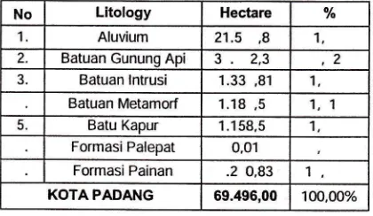
vi-sual potential for the city of padang, especiallythe beauty of the hills in this city, Geology and Soit Types
Geologically,
the
city
of
padang
isformed by the sediment surface, volcanic and
intrusive rocks and sedimentary and
metamor-phic rocks. The types found in the city
of
pa-dang consistsof
several species that spread across the region, as in TableGeologically, there are areas prone to soil movement. The region is located in Eastern
and Southern parts of the city of padang, which consists of Tangah Koto district, Kuranji District, Pauh District, Lubuk Kilangan District, Lubuk
Begalung District,
and
Bungus Teluk KabungDistrict. The region is prone to rock movement
are
Pauh
District, Lubuk
Kilangan District,Lubuk Begalung District,
and
Bungus Teluk Kabung District. Alternative plans that can becreated according
to
Joga (200)
is making aparticular spatial settlement whose activities
away from areas prone
to
soil
movement toavoid any casualties. Table . Types of Rocks in Padang
No Litology Hectare o/o 1 Aluvium 21.5 ,8 1, 2. Batuan Gununo Aoi
3.2,3
,2
3. Batuan lntrusi 1.33 ,81 1
Batuan Metamorf 1.18,5 1. 1
5. Batu Kapur 1 .158,5 1
Formasi Palepat 0,01 Formasi Painan .2 0,83 1
KOTAPADANG 69.495,00 100,00%
Source: CalculaUon Results ArcGlS Applications in
Regio-nal Development Planning Board (2008).
Land Use
The entire city of Padang
is
kmwide,
or
1.
5
of thee
uivalent area of West Sumatra Province. From these are more than0 ie
3
.
3
km
is
an areaof
protectedforest-covered hills, then the rest is the effective
urban area. The city of Padang has a coastline along the
8
km. The city government has set agreen zone in the coastal area between
500-1000 meters. Based on the area, the planning
that can
be
appliedto the
urban forest andmangrove forest which strongly supports the
goals of ecological city.
Land use in Padang is very diverse, of
which consists of housing, the area of trade and
services, industrial,
mi
ed farms, rice paddies,fields, forests , and others. Based on data from 200
,
the use of land in the cityof
Padang is dominated by open green space. Green spacewhich dominates land use in Padang consist of
the
forest nature reserve which hasan
area25
85.
hectares.ln
general, the percentageof
green spacein the city
of
Padangis
at83.0
.
This showsthat
urban green spacere
uirements by LawNo.2
of200
has beenreached, where
the
proportion of green space by law is30
of the entire region.This green space can be planned as a
shelter
for the
evacuated residents duringnatural
disasters, particularly
earth uakes.According to Joga (200
),
spaces that can be usedas
evacuation sites are greenways, cityparks,
neighborhoodparks,
parking
areas,PROSIDING SIMPOSIUM ILMIAH NASIONAL IALI 2O1O
spofts fields and other areas that support for
the
evacuation processesso as to
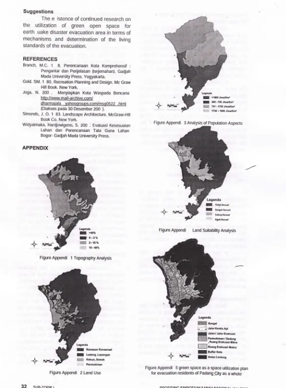
minimize casualties.Aspects of Population
Residents of Padang in
200
amountedto
838,10
inhabitants.which
con-sists of1
2 menand
21,2 B women. With a totalarea
of
km
of
Padang,the
averagepopulation density of
120
Padang inhabitant /km
Based on the Padang
in
Figures Year200
,
Bappeda and BPS cityof
Padang, the distict that has densest populationis
PadangTimur
Districtwith
densityof
10,
inha-bitants /km
. That district is a central activity of Padang, especially economic activities. Whilethe district has the lowest population density is
Bungus Teluk Kabung Disrrict with a populatio/ density of
23
inhabitants/ km
. This happy'ns because the location of this district is far fromthe
center city activities and land useof
the district is dominated by pro-tected forests.Population density
in
disasterevacua-tion
processis
very
closely relatedto
the effectiveness of community mobility during the evacuation process. Accordingto
Triseptyanti(2008), public perception at the time of
crowd-ed
conditionstend
to
be
poor due
to
the carrying capacityof
landthat
is
increasinglylittle
to
do activities, The more densethe
po-pulation, hence diminishing the effectiveness of mobility
in
the
evacuation process.lt
alsounderlines
the
planningin
densely populatedareas should make
a
clear circulation systemso there are no disorientation due to the largely number
of
human who were conducting theevacuation process during the earth uake.
PLANNING THE USE OF OPEN SPACE AS
A
GREEN SPACE EARTHQUAKE DISASTER EVACUATION
Basic Concepts of Planning
Study of green space utilization plan, is
based
on the
conceptof
urban green spaceutilization with
a
social approach.The
greenspace is functioned as a refuge or escape place
in the
eventof an
earth uake disaster. The purposeof
the
plan
by
using
this
socialapproach is to get an area that can facilitate the community
as
a
user
in
performing variousactivities, especially earth uake disaster eva-cuation. Green space
has
other functions incontrolling and improving
the
ualityof
urbanenvironment and directly add
to
the aesthetic [image:14.595.78.288.175.297.2]ualities of the city in order to reach an urban
layout
that
is
comfortablefor
peoplein
theiractivities. The concept of social approach of the utilization of green space was further developed
into
concepts relatedto
spatial, circulation,vegetation, activities and facilities that support
the
evacuation
of
residents during
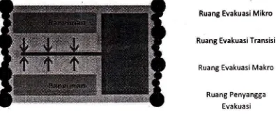
the earth uake.Concept Space
Green space used
as an
evacuationspace in the city of Padang is divided based on
social
approach.ln
social
functions, greenspace
was
instrumentalin
creatinga
harmo-nious region physically and psychologically, by
the
people (users) whowill
usethe
plannedarea. The concept of
the
use of green spacewith
a
social approach divides the space intoseveral parts,
the
micro-chamber evacuation,evacuation space transition, macro evacuation
chamber,
and
buffer space evacuation. The division of this space is shown in FigureRuang Evakuasi Mikro
Ruang Evakuasi TEnsisi
Ruang Evakuasi Makro
Ruang Penyangga
[image:15.597.77.275.341.428.2] [image:15.597.318.541.635.731.2]Evakuasi
Figure . Diagram of Distribution Space
Micro
evacuationspace
is
a
greenspace which were around the building structure.
ln
this space self-safety valueis
precedence.while the value
of
human activity in the massevacuation is more minimized. The use of this
space devoted to safety while self-rescue from
the catastrophic earth uake that potentially da-mage the building structure.
Evacuation transition space
is
spacethat
is
usedas an
escape route during the earth uake. The conceptof
sharing the other room in the concept of utilization of this greenspace
is the
macro evacuation space.ln
theplanning,
macro
evacuationspace
has
afunction as
a
space for mass communityeva-cuation
core.
Human activityin
macroeva-cuation space is more
ma
imized in the use of evacuation facilitiesthat are
availablein
agreen space.
ln addition to thai evacuation chamber,
the
distributionof
space relatedto
disastermitigation
is
buffer evacuation space. On thebuffer space, evacuation more functioned as a
buffer space
for
the
aftershocksof
the28
suB-roPlK iearth
uake
impacton
coastal areas.ln
this buffer space ,conservation activities of the city more dominatedto
avert another disaster like the tsunami disaster.Circulation Concept
The
conceptof
circulation within the utilization planof
green space asa
space for evacuation by utilizing circulation path that hasbeen there before. The
e
isting city circulationwas developed based
on
the carrying capacityof
the
road dueto
the
e
istenceof
the
po-pulation in the surrounding streets. According to Laurie(1
B ), a circulation path should be builtwith attention to functionality and effi-ciency so
it is profitable for its users.
According
to
the data until the end of 200 , the length of roads in the city of Padangviewed
by
function,the
longestis the
Local/
Secondary Road which is
58
.
3 km long, andArterial Secondary Road about
1
O.82 Km long,Collector Secondary Road about 120.81 Km,
and
Arterial Primary Roadabout
.
I
Km which type of construction of the whole surface is asphalt. This circulation path also has a roleas
a
temporary evacuationsite
for
peopleduring
the
earthuake.
The
concept
of circulation in this planning is divided into three channels,namely
primarylines,
secondary lines, andthe
tertiary lines.This
pathway isdistinguished by
a
wide body of road that canaccommodate
its
use
in
the
evacuation pro-cess during the earth uake.Primary
path
is
a
path
with
a
highintensity use in
the
eventof
earth uake, withthe
road widthof
approimately
-1
meters.The line was partly
an
arterial lane road andcollector road. Secondary path is
a
secondaryroad-street town with a width
of
appro imately3-
meters.
While other lines
of
tertiary channels. This path is the path that has a fairly narrow road agency is about 1-3 meters whichis
the
use
of
localtrails and
neighborhood streets.Figure 5. Diagram of Circulation Draft
Vegetation Concept
The concept
of
vegetationis
plannedwith the social approach has a role to facilitate
the public in the process of saving themselves from the impact of earth uake disasters and to
improve
the
comfoftof
urban communities incarrying out its daily activities. To support the concept
of
socially green space utilization, itre
uiresthe
selectionof
vegetationthat
areecologically
and
socially/culturallycan
esta_blish a sustainable ecosystem.
The use
of
vegetationin
urban greenspace
is
adaptedto
the conditionsof the
re_gion,
namely lowlands
and hills
plants.Structuring
the
vegetation contributeio
the comfoft and safety during the earth uake.Vegetation shade of green space used
as an evacuation of the space allocated to the semi-intensive zone
/
room. ln this zone thereare
activeand
passive activities. Vegetationseryes to create the impression of calm in the
evacuation area, so that psychologically in the
event of disaster, community's emotions are not easily provoked.
Cultivated vegetation deliberately
is
acrop
grown
for its
benefits
in
agriculturalproduction activities. Cultivated crop consists of vegetables
and
fruits.
Structuringthe
culti_ vationof
vegetationis
allocatedto the
macro evacuation space.Furthermore, the arrangement of
vege-tation for urban green space, the presence of buffer
is
absolutely necessary, especially in coastal areas. These buffer vegetations arenative vegetations such as forest and natural
forest gardens which directly adjacent
to
agri_cultural land owned by the community. Diverse
and
lush
buffer vegetation structureis
also [image:16.598.88.239.578.660.2]useful in water and soilconservation.
Figure . Diagram Concept Vegetation On Space planning
Activity Concept
The ioncept of the planned activities on the green space of padang which is used as
an
evacuation chamber
is
self_rescue activity tothe green open spaces. Self-rescue activity was
developed into activities
that are
social. SelfPROSIDING SIMPOSIUM ILMIAH NASIONAL IALI 201O
rescue activity undertaken
by the
society ofwhich ran to higher ground, gather and create a
temporary shelter, made public kitchens, and perform activities related to other emergencies.
Facility Concept
Supporting
facilities
are
planned to supportthe
functionsand
activitiesof
self_ preservationon
urban
green space.At
themicro
evacuationchamber
and
evacuationchamber of transition, the type of facility that is developed
is
limitedin
accordance with the needsof
the
communitythat
is
around thespace. At the macro evacuation space, types of supporting facilities
is
made more diverse to accommodatethe
needs
of
citizensin
thearnount of mass evacuation.
Facility supporting earth uake disaster evacuation green space can be divided into two
pafts,
the
basic
amenitiesand
supportingfacilities. Basic amenities consist
of
goods atthe
timeof
evacuationof
grassor
ield
ag{
evacuation routes. While supporting facilitiei in
the process of self-preservation, including tem_ porary shelter, bench, shelter,
sign
board or board of directions, availabilityof
clean water,medicines,
food, toilets,
garbage cans, andlights.
Planning
.
Essentially, geotogical disaster mitiga_ tion is to reduce the risk of geological disastersto
property and humanlife.
lt
takesa
colla_ boration betweenthe
engineers andthe
go-vernment
as
an e pert
policy
makers who produce development regulationsin an
area prone to geological hazards, (Joga, 200 ).ones in the planning
of
a
cityis
the first step and the most fundamental in reducingthe
damage
caused
by
the
earth uake.Planning a better space in which a seismic risk
area,
will
havean
impacton
determining thebest place is the development zone in tne city.
Field
observations showedthat
the majorityof
peopleof
padang want multiplica_tion
gardensas
green space. parks can beused
as
a
space self-saving duringearth-uakes and other disasters. park
is
aGo usedas a residence after a disaster, and is used as a
location for securing themselves from the threat
of earth uake aftershocks.
Green Space City plan
Green space padang plan
is
used asan evacuation chamber during the earth uake
is based on the-analysis results obtained. The
planned
space order
is
divided
into
four sections, namely (1) micro-chamberevacuati-on, (2) transition evacuation space, (3) macro
evacuation chamber, and
(
)
buffer evacuation chamber.Micro evacuation space.
ln
this spaceusers
in the
process saving themselves from the threat of collapse of buildings. This space isa parking area and garden.
Transition evacuation space. ls a space
which
is
used
as
an
active space
in
the circulation duringthe
earth uake. This transi-tional space consistsof
trailsthat
lead
into areas with higher topography.Macro
evacuation
room
showedactivities in
a
mass emergency. Range of timein this activity is relatively much longer than the micro evacuation chamber. At the macro
eva-cuation space is also needed a more complete
supporting facilities because
it
involves the interests of more number of users. Macroeva-cuation space plan includes an open space in
the form field with grass that lies on
a
highertopography.
This
spaceis
locatedin
certaindistricts
in
the
easterncity
of
Padang, the Lubuk Kilangan District, Koto Tangah Dis-trict,Kuranji
District,Pauh
District,and
BungusTeluk Kabung District.
ln the process of evacuation,
is
need-ed space that protects users from the threat of catastrophic aftershocks. Space can be a buffer
space city that shaped space con-ser-vation. ln
this planning space is called a buffer evacuation
space.
This
space
consists
of
spaceconservation of protected forests upon the top
of
the
slopeof
the
high land and mangroveforests along the coast.
Vegetation Plan
Bio-geographical conditions
of
naturalenvironment
has
showed habitatfor
varioustypes of vegetation the most appropriate as a
reference plant selection
for
green space of each room. Selectionof
vegetationin
urbangreen space plans that were presented in
ge-neral use
in
accordance with vegetationeco-systems and habitats
to
be considered on thebasis of appropriateness of form and function of the architectural form of vegetation is used as
the basii of the ne t selection.
Circulation
Plan
for
Earthquake
Disaster EvacuationCirculation model
in
disasterevacuati-on space in Padang utilizing circulation patterns
that have been there before. ln the process of evacuation,
the
local people usually use theirvehicles to immediately go to places with higher
topography to avoid the impact of the tsunami as the aftershocks from
the
uake. Thereforere
uired some changesin
circulation models,especially
on
trails
that
lead
to
the
macroevacuation zone larea. These changes include
changes
in
width
evacuationroute
to
the locationof
the
macro
evacuationand
the addition of board of directions that facilitate the communitiesin
accessing macro evacuation space.Plan of Green Space Evacuation Activities and Facilities
Activities developed
in the
evacuationchamber
consist of
emergency activitylha/
re
uires some facilities that could support the evacuation process. The facilityis
planned tobe developed in each space. The office of micro
evacuation, evacuation activities
tend
to
be temporary. ln this space people tendto
waituntil
the
earthuake
activityis
finished and waiting for the aftershocks to avoid the collapse of the building.When an earth uake occurs in
a
longtime and with great force, then the people who
were
in
the
micro evacuation space imme-diately evacuateto the
transition evacuationspace with fast walking or running activity
iqd
not infre uently who use motor vehicles to th'e
location with the higher topography. Necessary
facilities such as trails, signage towards macro
evacuation chamber,
and
is
e
uipped withvegetation attempted not
to
interfere with theprocess.
When
an
eafthuake
destroyed the structure of the building, the people who suffer the ruins of the building should evacuate in the open place whichis
e
uipped with supportingfacilities
such
as
open fields, clean
water, medicines, temporary shelter, emergency toilet, kitchen, tools form of ambulance transportation and other support facilities.Power Support of Green Open Space Disaster Evacuation
Calculation of bearing capacity of
green
open space is intended to support
the safety and
lmfon
during evacuation in a green open space. Carrying capacity in this spaceii
catcutated basedon
circulation facilities, emergencytent facilities
and
space available,,
tu,ipo*ry
evacuation chamber. Facilities that allow'contiineOin
this space include the circulation path.According to data from the end of 200 ,
the len$h
of
roadsin
the
cityof
padangis
viewed
by
function longestSlcondary
Local
Road
and
Arterial. RoaJ primary, Secondary and Collector Road primary Rrteriat Road. Thetotal overall length
of the
roadin
the
city of Padangis 1.j
km, with atotal area of the
road about 135 Ha. Thus, assuming the entire
community to do the evacuation pr6cess with_
out
boardedthe
vehicle, thenget
a
carrying capacity for roads in the city of pidang is:
-
Roads Areatm2tr otat population (nhabitants)
^-J.350.000m?
1, Zmzlinhabitants838.1 0 inhbitants
Carrying
capacity
in
this
space
is
calculated
based
on tne
e isting
iacilities.
Standard room tents
In
evacuatioi,pu."
i,
divided into macro command tent with the sizeof
meters with a carrying capacity of g0_10people, team tent with the size
of
S
meters1ft|
,
carrying capacityof
15_25 plopre, anoptatoon tenr with the sizL
of r ,i.i"[
wirh acapacity of 30- 0 people.
ln
this
planningto
use
public toilet facilities in the form orai
emergen.y,oii",.ft,i,
toilet isa
new kind of toilet units tf,ai,."
onfy0.
liters per shower could save25
ofwater use for househotds without sacrificing comfort
and public heatth.
Landscape ptan
.,
Green space asa
space utilization planthe evacuation of residens of padanf
u.
u*hof"
shoyvn in Figure 5. Measures
takenio
,*Lipu,"
earth uake hazard in a city can be on" oitnurn nyway
of
preventionof
deve_lopmentin
low_tying
areas that are too close to the beach. this is OaseO to. prevent loss of tife
and other property-due to other effects caused by the earth r.jutJ, pJni,.rluriy
the impact of the tsunami.
This land suitability analysis
is
based
on
land suitability standardsfor
ine
camp OyPROSIDING SMPOSIUM
ILMIAH NASIONAL IALI 2O1O
Widyaatmaka (2_00
)
is apptied using the soft_ware ArcView
GIS
3.2
map overlaymethod.
Overlayed thematic maps incluOe
-a
map of slope, elevation maps, geological maps, land
use
maps,and
mapsof
populationdensity.
From
the
resultsof the five'mapi
intersect,
found
that
a
very
suitable
area
for
theevacuation area
of
2 t
hectares (0.3
), wide
area that has kesesuain moderate (mode_rate Suitabte)
of
3523.
hecrares(
.
5
),
broad areas that have low fitness (marginally Suitable) of11
3
.112 hectares(15.35 )]anJireas
tnatdo
not
fit
(not
Suitable)nas
un-ur.u
of53
0
.35
hectares(
O.g
).The results of this planning is a map of landscape planning that consist,
if ,
room of evacuation of green open space and trails that take advantage of the evacuation,ori"
that has been there before.Planning programs Utilization of Green Space as the Earthquake
Disastei
Evacuation Areasupport the efforts of this disaster.
other
re
uire good ptanning, urroi"
,r#=tr*
cooperation of various parties concerned. This cooperation
re
uires planning program thatis associated with the implemeitatioi timeframe. lmplementation time frame is divided-into three period, namely
the
short and long term.fhe
program is aimed at planning for
tie
effective_ nessof
the useof
greenop"n
spac" for the community duringthe
earth uake, andas
alt1yc1yrtn9 activiry or mechanism oi evacuation
activities in the city of padang.
CONCLUSIONS AND SUGGESTIONS
Conclusions
Acivities
developedin
tnlframOer
evacuation of emergency activity thatre
uiressome facilities that could support tne
evacuati-!n.
Rr.ocess. Bio-geographical conditions of natural environmenthas
habitatfor
varioustypes
of
vegetation showedthat the
most appropriate
as
a
reference plant selection for green space of each room. Calculation of bear_
ing capacity of green
open space is intended to
support
.the
safetyand
comfort during eva_cu.ation
-in
a
green open space. On the utili_zation of green open space for area evacuation, needed ade uate facilities,
a
clear"r;;;;
mechanism and
a
system that facilitateseva_
cuation activities
,rryuruut
to
preventcasual-ties when disasters occur.
Suggestions
The
e
istence of continued research onthe
utilization
of
green open space
for earth uake disaster evacuation area in terms ofmechanisms
and
determinationof
the
living standards of the evacuation.REFERENCES
Branch, M.C.
1
8. Perencanaan Kota Komprehensif :Pengantar dan Penjelasan (tedemahan). GaQjah
Mada University Press. Yogyakarta.
Gold. SM. 1 80. Recreation Planning and Design. Mc Graw Hill Book. New York.
Joga, N. 200
.
Menyiapkan Kota Waspada Bencana http://www. mail-archive.com/dharmaiala yahoogroups.com/msgO522 .html (Diakses pada 30 Desember 200 ).
Simonds, J. O. 1 83. Landscape Architecture. McGraw-Hill Book Co. New York.
Widyatmaka, HarQjowigeno, S. 2OO . Evaluasi Kesesuaian
Lahan dan Perencanaan Tata Guna Lahan
Bogor: Gadjah Mada University press.
[image:19.596.25.592.22.790.2]APPENDIX
Figure Appendi 1 Topography Analysis
Legada
I l(awasan Kon$vasl
f Ladang,Lapangan
W-r:, K*un,Semak
-::t. Pemuklman
Figure Appendi 2 Land Use
32
suB-ToptK iFigure Appendi 3 Analysis of Population Aspects
Legenda
I lldaksesuai
f Sangatsesuai
H#ffi crkupsesuai
AEaksesuai
Figure Appendi Land Suhability Analysis
+
irr:i*
Legenda
I >lE00Jiwa,lt(r2
t :!60 - 730 JiwrKm2
ffiffi z:t - r?3s .liwalxm, r+ir ii ,736 - tSoo Jiwa/Kdp
+
r#.r*
Legenda
Wsong.i
i:*JalwKectaApi
: Jalar/JalurEEkuasi
l]ffi PemukimanlGedung
r Ruang Eyakuasi llikE
EE: Ruang Enkuasi ltakrc
f Buffer(ota
f Hutanunaung
+
Figure Appendi 5 green space as a space utilization plan
for evacuation residents of Padang_9ry as a whole
pRostDtNG stMpostuM tLMtAH NASIONAL tALt