DOI: 10.12928/TELKOMNIKA.v14i2A.4377 200
Construction and Realization for Multi-dimensional
Database Based on RDBMS
Feng He1, Wang Yu2 1
School of Mathematics Physics and Information Engineering, Jiaxing University, Jiaxing, Zhejiang, 314001, P. R. China
2
Library of Jiaxing University, Jiaxing, Zhejiang, 314001, P. R. China *Corresponding author, e-mail: [email protected]
Abstract
Based on ArcSDE, this paper has proposed a new construction and management method for spatial database which has better performance than the traditional method. Up to now, there are four kinds of management about GIS database:whole file pattern, the combination pattern of file and DBMS, whole DBMS pattern and object oriented pattern. In fact, the two former ones is managed by separating spatial data and attribute data, which results into many problem: the low query efficiency, the higher management difficulty, the problem of data communion, etc. Object oriented pattern, however, still need further research. So, for a long space it is still need DBMS co-work to constructe spatial database.ArcSDE is a server software product of ESRI used to access massively large multiuser geographic databases stored in relational database management systems (RDBMS). Being different from other database product (Oracel Spatial), ArcSDE provides a suite of services that enhance data management performance, extend the range of data types that can be stored in a RDBMS, enable schema portability between RDBMSs, and offer configuration flexibility.
Keywords: ArcSDE, database, Spatial
1. Introduction
Spatial database system as the core, are the pillars of development of GIS technology, but also a database of research projects that break the traditional database application system is mainly based on information of words and numbers can be used to store and analyze massive amounts of information with complex structure. Does not have a complete and efficient spatial database based on GIS system is impossible to achieve good results.
Database is a service for certain purposes, stored in a specific data format associated with the data set, it is evolved from the document management system, is a senior data management stage. Spatial Database is stored with the collection of spatial data. It is based on the 3S technologies, database technologies, and network technologies, to manage spatial data technology systems, including 3S data storage structure, spatial data index, use the standard and operation model of technical content.
ArcSDE was there to address the diversity and complexity of DBMS. ArcSDE architecture gives users great flexibility. It supported databases include: Oracle, SQL Server, DB2, and Informix.
2. Overview of Spatial Database and its Development 2.1. Description of Spatial Database
As the information society, requires that the computer can not only carry out scientific calculations and simple processing of large amounts of data (such as data query and update) to make computer applications from the science sector and gradually extended to enterprises, administrations, resulting in database technology [1]. Database technology is an important branch of the field of computer; the core task is to manage the data. Database technology in the late 60 and have now formed the large scale system and use technology.
relational database system, developed to the third generation of database system based on object-oriented model for the main character.
Database and network communication technologies and artificial intelligence technology, object-oriented programming techniques, introduce, such as parallel computing, with each other, become the main features of database technology.
GIS Spatial database system as the core, are the pillars of development of GIS technology, but also a database of research projects that break the traditional database application system is mainly based on information of words and numbers can be used to store and analyze massive amounts of information with complex structure [2]. Does not have a complete and efficient spatial database based on GIS system is impossible to achieve good results.
2.2. The Concept of Spatial Database
Database is a service for certain purposes, stored in a specific data format associated with the data set, it is evolved from the document management system, is a senior data management stage. Spatial databases are stored with the collection of spatial data. It is based on the 3S technologies, database technologies, and network technologies, to manage spatial data technology systems, including 3S data storage structure, spatial data index, use the standard and operation model of technical content. Database systems are data-centric, specializing in data management of computer systems, the database system's main task is to design data, is looking at how to describe the objective world as research in database technology data.
2.3. Characteristics of Spatial Database
GIS database in addition to the General data features, also has a number of different from other general database features, mainly in the following several areas: Spatial characteristics are the main characteristics of spatial data, which describes the space object location, shape, even describes the object's spatial topology relations. For example, describing a river, general data focused on the drainage area of the River, water flow, in dry season, and spatial data focuses on describing the position and length of the River, birthplace and position-related information, such as complex also need to deal with the rivers and basins of rivers, such as distance, azimuth between spatial relations. Spatial data describes the real-world features, complexity must be abstract. In different aspects of the abstract, of the same nature may have different semantics. Spatial topological data structure of data records to express a variety of spatial relationships. This Characteristics of topological data structure, on the one hand easy to query spatial data spatial analysis, on the other hand also to spatial data consistency and integrity maintenance increased complexity. Observation on different scales with different scale and precision, the same object in different cases, there are morphological differences. For example, any area of the city in the geographical space occupied a range, can be seen as planar space objects. In a smaller scale GIS database, the city is treated as a point-like object. Spatial data cannot meet the relational database "structured" requirement. If a record expression into a spatial object, it may be variable-length data items. Such as 1 arc segments, its length is not limited, are 2 pairs of coordinates, or it may be 100,000 pairs of coordinates. Each space object has a classification code, and this classification and coding tend to belong to the State standards or industrial standards, each type of farming in a GIS of the property item number is the same. In many cases, a data object type corresponds to a property sheet file. Spatial data is enormous and often refer to the huge amounts of data. A city may as dozens of GB of GIS data, such as considering the storage of image data, possibly up to hundreds of GB or even TB level. This amount of data in a common database is very rare.
2.4. Mode and Development of Spatial Database Management Systems
management, relational database management and object-oriented database management mode.
In order to overcome the limitations of relational database management of spatial data, object-oriented data model is proposed, according to these proposed object-oriented databases. Application oriented object database management GIS of space data, can through in oriented object database in the increased processing and management space data function of data type to support space according to, including points, and line, and surface, geometry, and allows defines for these geometry of basic operation, package calculation distance, and detection space relationship, and even more complex of operation, as buffer analysis, and superimposed meet points model, also can by object database management system "seamless" to support. Study on the construction and management of spatial database based on ArcSDE object database management system provides for consistent data access interfaces as well as part of the service model [3], not only to achieve the sharing of data, and spatial modeling services can also be shared, GIS software can focus on performance data and develop complex professional model. However, the object database management system at present is not yet mature; many technical issues still need further study. Geographic information system for the management of data has come from the file system to "double-database" system, a complete relational database and to the development of the object-relational database system.
3. Research on ArcSDE 3.1. Overview of ArcSDE
ArcSDE (Spatial Database Engine) is a server-software sub-system (produced and marketed by Ezra) that aims to enable the usage of relational Database Management Systems for spatial data. The spatial data may then be used as part of a geo-database. ArcSDE grew to meet the need of users of geographic data for robust multiuser editing,storage and access of extremely large geospatial databases. It integrates the spatial data and attributes data [4]. Thereby enabling the seamless connection between spatial data and attribute data.
Multi user management: Sharing of Spatial data is to meet people's needs. In order to achieve shared multi-user spatial database engine services, multithreaded execution provides the user, support for multiple users concurrent access to the database, you must create and maintain a user's information, ensuring that users legitimate access to a spatial database.
Spatial database management: In order to meet people's demand for information sharing, often require simultaneous operation of several spatial database. This requires the establishment of spatial database for the user management, information about maintaining spatial databases, user-friendly operation to a different database, enabling user-transparent, secure access to spatial data.
3.2. ArcSDE Storage Modes
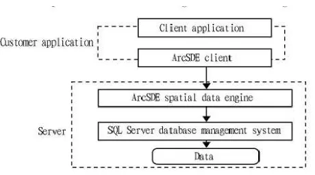
SDE is storage and organization models in spatial data types added to the relational database, it does not change and impact the existing database or application. It joined graphic data to an existing table entry (Shapecolumn) for software management and access associated with spatial data. SDE geo-data and spatial indexes on a separate table, through key items linked to it. Adds the graph data to a database table, the table becomes a "space available". SDE by putting it into a table to manage the space available. Space available, but as usual to query the data in the table, merge, or graphics can be made to the property or properties to a shape query. ArcSDE mainly through industries.Table (database table), a feature table (element table) and spatial index tables three tables for the storage and management of spatial data. Their interrelationship with spatial patterns can be expressed by the following Figure 1.
3.3. ArcSDE Spatial Data Model
In front of the introduced spatial data model of a relational database, there is a need to introduce data model. Data model is the so-called modalities for the Organization and management of spatial data, which enables computers to manage numerous spatial data. Pros and cons of data model determines the strength of data management. At present, the General data types commonly used in the field of organization and management of data have a hierarchical model, network model, relational model. Because of the complexity of spatial data, several common data types mentioned above are not in good management of spatial data, resulting in improved GDF model based on the above model and the OpenGIS model.
Figure 1. The ArcSDE + SQL Server Architecture Diagram
GDF model. GDF model was designed to meet certain standardized, structured data production and update of road networks and application needs of personnel and organization of the work issued by the International Organization for standardization. Depending on the application requirements, defines the Basic expression unit – the road network node, the edge and face between three different topology, or road networks in full topology (Full Topology), Connectivity Topology and non-explicit topology. Making the standard was designed by a model based on customer demand and manufacturers to design and build a common reference model for data, improve roads-related geographical information acquisition, production and processing efficiency.
GDF data model to abstract real-world geographical entity and relationship, established a number of known geospatial window bounded by geographical area, data area or workspace. Workspace is divided into a number of maps (Section) to map as the base unit, that is, a map constitute a data storage unit, with separate data entry and storage management. Each block contains several geographic features layer, elements of the geometry in the target form a plane, topological relationships between established goals. Between each of the elements in the data on the Organization and structure of relatively independent operations such as update, query, analyze, and display data with element layer as the base unit. Geographic features include
GDF data model to abstract real-world geographical entity and relationship, established a number of known geospatial window bounded by geographical area, data area or workspace . Workspace is divided into a number of maps (Section) to map as the base unit, that is, a map constitute a data storage unit, with separate data entry and storage management. Each block contains several geographic features layer (Layer), elements of the geometry in the target form a plane, topological relationships between established goals. Between each of the elements in the data on the Organization and structure of relatively independent operations such as update, query, analyze, and display data with element layer as the base unit. Geographic features include
surface describes the spatial location of geographical entities, spatial distribution and spatial relations are geographically inseparable smallest unit stored and managed in a database [6, 7]. Often in geographic databases, a geographical element entity consists of a geometric elements and describe the geometric properties of the element, or semantics of elements in two parts. Simple elements element represents a point (Point Feature), the line element (Line Feature) and surface elements (Area Feature), describes the geographic significance of geometric elements. But simple is not a one-to-one relationship between elements and geometric elements, simple elements is based on the geometric elements of the add attribute information. Composite elements are simple elements or multiple elements with the same properties and property set. Elements of real-world geospatial, map, geographic data and geographic objects form a hierarchy model framework. Each map in the establishment of their own independent of the topology of relationships with other maps by longitude and latitude or rectangular block adjacency relationship established. Links between elements is through "relational tables" established.
OpenGIS is governed by the open geographic information systems was founded in 1994 by developing [8], its original purpose was to provide a comprehensive suite of open interface specifications to facilitate the development, developers can write interoperable components based on these specifications, transparency in geographic data processing in order to meet the needs of GIS interoperability.
Open GIS one open interface specification provides a set of generic components, developers based on these specifications to develop interactive components, these components can implement different types of spatial data and geo-processing method of transparent access
ArcSDE, employs the model of improvement of the GDF. In ArcSDE data models, maps and layers of geographic information storage and management. First, the geographic information can be divided into a number of layers in the vertical, each layer storing spatial data of the same type. Also, geographical information on the transverse framing store in accordance with maps. Among them, the layers and maps are equal, a layer can contain multiple map, and a map can be divided into multiple layers. Maps and information that defines the layers are described by the map table and Layer Description table to record them. Maps and layers between each of the cross (that is, a layer of a map, or a layer in a map format), corresponds to the appropriate space Data sheet, store the image in the layer space of the data (including spatial data and attribute data).
4. Management and Optimization of Spatial Database Based on ArcSED 4.1. Necessity of Optimization of Spatial Database Management
Database applications in GIS application model was thoroughly changed [9], it not only solve the problem of data storage management in the traditional sense, also solves the user editing, data integrity and data security and many other issues, is critical for GIS applications.
From database design, data processing, to final data warehouse storage, which implements the basic database. At this stage, for applications based on spatial database development can be achieved, but from its effects, but due to management differences, the database is optimized or not produce quite different. Moreover, the optimized management of the database is also an important means to improve the life cycle of database [10, 11].
4.2. Spatial Database Concurrency Management
Surveying and mapping spatial database is built on the structure of GIS application system based on US, in its practical application, must be for multiple users. Then the problem of concurrency control for multiple-user access is a situation that must be taken into account.
4.3. Backup and Recovery of Data
For a frequently modified database, in order to minimize the recovery time, you can perform incremental backups of the database. Only after you have performed a full database backup, you can perform an incremental backup. Incremental backups, the backups of the SQL Server system database that have changed since the last full backup section, including performing incremental backups performed during any operation, as well as any uncommitted transactions in the transaction log.
When the database is very large, data file or file-group backups can be performed. File group contains one or more database files. When SQL Server 2000 systems when backing up files or file-groups, it can back up only the FILE option or FILE GROUP option is selected in the specified database file, and allows you to back up only the database file rather than the entire database.
5. Experiments and Results Analysis
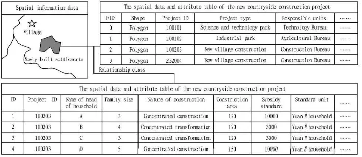
First, we establish the primary key in the spatial database layer and conduct unique coding on each spatial element according to certain criteria; the professional project attribute data are also regarded as the foreign key of data table through corresponding encoding. The primary key and foreign key have the same data type, and convey the same type of information. Taking the spatial data origin class and thematic attribute data as destination class, the relationship classes between them are established, to correlate the spatial entity in the layer and the attribute information corresponding to the entity. Figure 2 takes the new countryside construction project and the corresponding new village construction subsidy to farmer for example, to illustrate the association between spatial data and attribute data.
Figure 2. Correlation between Spatial Data and Thematic Attribute Data
Based on the above analysis of the building of new countryside construction database,we use the following method to establish the database of provincial new countryside demonstration zone in
form each complete layer within the framework of region. The non-spatial data include professional attribute data and general form. For the attribute data, the unique code is set in the corresponding spatial data processing, and the spatial entity and attribute records are correlated using space link tools; the general forms are processed using Excel. The data are imported using Arc Catalog in the ArcGIS Desktop.
Figure 3. The Database Construction of Provincial New Countryside Demonstration Zone in Yanjiang District
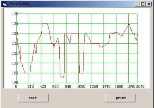
In the experiment of testing efficiency, can be seen as the database grows, ArcSDE ensures good stability, makes the database more efficient. Figure 4 shows the efficiency map.
Figure 4. Efficiency Table
6. Conclusions
about providing meteorology services targeted at agriculture, rural places and farmers, but we believe that with the strong support of all-level government and the efforts of relevant departments, the meteorological service work will definitely play a much more important part in reducing disasters and increasing farmers' income such important issue that leaders of the Central Party Committee and the State Council have paid great attention to.
Acknowledgements
This work is supported by the scientific research project of the Jiaxing University (No.70513013).
References
[1] Wang J. Research and development practice of new countryside planning management operating system. Xi’an: Chang’an University. 2011.
[2] Wang F, et al. Study on spatial database based on ArcSDE. Site Investigation Science and Technology. 2011; (5): 50-54.
[3] Zhang N, Gong Hl, Zhao Wj, et al. Study on the development and application of GIS based on SDE and MapObjects control. Journal of Capital Normal University (Natural Science Edition). 2011; 101-105.
[4] Kenward T, Lettenmaier DP, Wood EF, et al. Effects of digital elevation model accuracy on hydrologic predictions. Remote Sensing of Environment. 2012; 432-444.
[5] YE CL, Study and design on spatial database of underground pipeline in Foshan City based on ArcSDE, Changsha: Central South University. 2012.
[6] Tang Minan, Wang Xiaoming, Yuan Shuang. Site Selection of Mechanical Parking System Based on GIS with AFRARBMI. TELKOMNIKA Indonesian Journal of Electrical Engineering. 2013; 11(7): 3935-3944
[7] T Sutikno, D Stiawan, I.M.I Subroto. Fortifying Big Data infrastructures to Face Security and Privacy Issues. TELKOMNIKA Telecommunication Computing Electronics and Control. 2014; 12(4): 751-752. [8] Dadkhah M, Sutikno T. Phishing or hijacking? Forgers hijacked DU journal by copying content of
another authenticate journal. Indonesian Journal of Electrical Engineering and Informatics. 2015; 3(3): 119-120.
[9] Chakraborty K, Roy I, De P, Das, S. Controlling the Filling and Capping Operation of a Bottling Plant using PLC and SCADA. Indonesian Journal of Electrical Engineering and Informatics (IJEEI), 2015; 3(1): 39-44.
[10] Thomas. Devogele on spatial database integration. Geographical Information Science. 1998; 12. [11] Lazimov TM. On convergence of Carson integral for horizontally layered earth. Balkan Journal of