HYDROMORPHOLOGY OF THE UNCONFINED GROUNDWATER IN THE SOUTH OF KLATEN DISTRICT
(Data before Earthquake Mei 27th 2006)
by:
Langgeng Wahyu Santosa
Physical Geography Department, Faculty of Geography, Barek Street, North Skip, Bulak Sumur, Gadjah Mada University, Yogyakarta
Phone (0274) 6492332, Fax (0274) 6492348 E-mail: [email protected]
ABSTRACT
T
here are some characteristics and distributions of unconfined groundwater variation in the research area.Those are related to a system of water supply and consumptive use for drinking water. Variation of the groundwater characteristic depends on variation of morphology. Therefore, it is needed to delineate hydromorphology units of the regions as a base on groundwater resources management, especially for drinking water.
The aims of the research are: (1) to study of the characteristic and distribution of unconfined groundwater variations base on landform units, (2) to study the factors that affect such variations, and (3) to establish the hydromorphology units of the regions for groundwater resources management, especially for drinking water. The method used in this research is landform approach and field survey. The sampling method is stratified sampling, based on landform as the analysis approach.
Result of the research shows that there are some variations of groundwater characteristic at each landform. Landforms which have good groundwater characteristic are Hydromorphology Unit of Fluvio Volcanic Plain of Young Merapi (except Bayat region) and Hydromorphology Unit of Volcanic Foot Plain of Young Merapi. At those units, there are good quality of groundwater, bicarbonate water (hydrochemical type I), having low electric conductivity, shallow of water table, low in fluctuation, and middle to fast class in aquifer permeability. Those units are the most potential unconfined groundwater resources management for drinking water. The units which have poor groundwater characteristic are Hidromorphology Unit in Bayat Region, including Undulating Alluvial Plain, Fluvio Volcanic Plain of Young Merapi, and Swamp Alluvial Plain. Generally, the groundwater quality is medium to poor, the hydrochemical type is Va (initiation process of connate water) and type III (evaporate water), shallow up to medium of water table, and low to middle class of aquifer permeability. The taste of groundwater is brackish to saline with high concentration of chloride.
Keywords: Hydromorphology, Hydrochemical, Unconfined groundwater, Landform
INTRODUCTION
Background
Groundwater issue is a complicated study and has important meaning for hu-man being, especially for the use of drink-ing water need or other need. The planndrink-ing of usage, management, and groundwater conservation are needed in the light of the importance of this natural resource for the
is characterized by the present of earth sur-face topography or relief, the genesis, geo-morphologic structure, and its compound-ing material. Each compoundcompound-ing material of the landform will affect the groundwa-ter condition, either the quality, the depth of groundwater surface (water table), groundwater movement, hydro-chemical type, or its aquifer permeability. Hence, the condition of groundwater in a region can be shown with the hydromorphological condition of that region.
The characteristic and the distribu-tion of unconfined groundwater in South-ern Klaten District is interesting enough and needs to get attention in the relation with the effort of primary water providence. In certain locations, such as in Bayat, groundwater is difficult to obtain with well condition, there is brackish or even salty groundwater, causing low quality of groundwater and not good from drinking water resource. In several places, the citi-zen has to take water from the spring in other place for the need of drinking water or other household needs. Meanwhile, in other area, the groundwater condition is still good enough, but there is only a prob-lem on the high fluctuation of water table between dry and rainy season. In rainy sea-son, the groundwater is shallow enough and easily obtained, but in several area, in dry season, there are many dried wells (the groundwater surface goes down dramati-cally). Such a condition is certainly affected by geomorphologic and geologic general condition of the district. The existence of salty water (low quality of groundwater) is possibly affected by the genesis of the re-gion, and related to its content litology. The difference of high fluctuation groundwa-ter between one place and another is pos-sibly affected by the condition of different
containing materials, the variation of struc-ture and geomorphologic process, and also by different sedimentation environment.
The geomorphologic condition and the genesis of a region seem to have a main role in the difference of unconfined groundwater characteristic in this region. In the unit dominated by volcanic materi-als of Young Merapi relatively has better groundwater condition than the groundwa-ter condition in the unit of ex swamp allu-vial plain, such as existing in Western Gantiwarno Sub District. This unconfined groundwater condition will have difference directing to the east following the stream of Dengkeng River, and the getting lower of its quality in Bayat, especially in ex swamp alluvial plain around Jombor Swamp. Such a groundwater condition is interesting to study, related to the effort to plan the groundwater usage and primary water providence system from drinking water in southern Klaten District.
The research field was included in southern Klaten District, including Prambanan, Gantiwarno, Wedi, and Bayat Sub Districts, in fact has various morpho-logical views, arranged by various litology, and formed by the effect of various activi-ties or geomorphologic process working either in the past or recently. Complex mor-phological representation clearly will de-scribe the variation of existence and its groundwater characteristic. Unconfined groundwater hydromorphology study has a very important meaning as the initial step in planning the usage and the management of groundwater resource.
landform unit is comprised of the aspect of relief or topography, structure, and the geomorphologic process (genesis), and its compounding materials. The varia-tion of landform representation will show the varia-tion of groundwater and its charac-teristic, shown by its hydromorphology unit.
Problem Formulation
Based on its genesis, the formulation of southern Klaten District landform (Bayat and the surrounding) is affected by two factors, the process started from Pre-Tersier era, in the form of sea trough, and followed by the process of fluvio-volcanic of Young Merapi up to now (Bemmelen, 1970). As the result of gradual tectonic stages, according to Hadi Sutomo (1990), it causes various morphological represen-tations, which can be controlled by the structure and the type of rock compound-ing it. Oceanic plate movement, the activi-ties of volcano (fluvio-volcano) and geo-morphic power working in sequence, results total change in the research field generally from a shallow sea (lithoral zone) into a land with various morphological representations recently. Such a condition will affect the variation of groundwater characteristic and providence, results another problem for the citizen in obtaining primary water, espe-cially for drinking water.
Based on this problem, it reveals question on: “Why there is variation and groundwater providence in this area?” Based on this formulation, it occur several research questions, which can be studied further:
(a) How are the variation of characteristic and the distribution pattern of uncon-fined groundwater in the research area? (b) What factors affecting the characteris-tic and the distribution pattern of
un-confined groundwater in the research area?
(c) How is the effort to plan the usage and the management of groundwater re-source, its relation with the priority of primary water for drinking water?
To answer those questions, one of the approaches taken in order to overcome the problem and formulate the direction of groundwater usage plan for drinking and primary water providence system is to ar-range hydromorphology unit.
RESEARCH OBJECTIVES
Based on the research’s problem above, thus this study has main objectives of:
(1) Studying the characteristic variation and the distribution pattern of uncon-fined groundwater in the research field based on its landform unit;
(2) Finding out and studying the factors affecting the characteristic variation and the distribution of unconfined ground-water in the research area; and
(3) Managing hydromorphology units in research area as the basis for the ar-rangement of direction priority of the use of groundwater, especially uncon-fined groundwater for the primary wa-ter need of the people in research area.
THEORETICAL REVIEW AND FRA-MEWORK
Theoretical Review
Groundwater is water located inside of the pores in geological layer (Todd, 1980). Un-confined groundwater is groundwater ex-isting on the impermeable layer up to the water table under the land surface. Several important aspects related to groundwater is geomorphology, including in it is geo-logy affecting the distribution of ground-water, hydrologic cycle determining the sup-ply into the ground, and fluid mechanical about its movement. These three factors have strong effect to the position and the condition of groundwater (Soemarto, 1988).
Groundwater exists in several geo-logical types. One of the most important is aquifer, a rock formation that can keep and release groundwater in adequate amount (Todd, 1980). The character of the ability of a rock layer to release water, related to the water movement in the pores of the rock is called as permeability. This is the thing affecting the reservoir potential or groundwater discharge in aquifer. The rock characteristic and the ability of aquifer strongly determine the quality and quan-tity of groundwater existing in it. One of the geomorphologic approaches to study groundwater is the arrangement of hydro-morphology unit, as stated by Verstappen and Zuidam (1968) in Sutikno (1992). This is caused by the main component of geo-morphology are the factors affecting the characteristic of groundwater.
Hydromorphology unit is a ground-water unit reflected by the condition of its geomorphology with landform unit as the basic of main analysis. According to de Rider (1972) and Sutikno (1989), landform unit, generally will affect the distribution of groundwater. Landform unit is shown by topography and litology of a region, while topography of a region is controlled
by the geological structure underneath (Robert, 1982). One of the morphological features of research area is the process variation, structure, and arranging litology or materials. The variation or the difference of litology will affect the difference of groundwater quality (Hem, 1970), and the aquifer permeability coefficient as the mea-surement to the relative potential of groundwater (Todd, 1980). Based on this though, thus the landform unit can be used as the basic for the arrangement of hydro-morphology unit, especially in unconfined groundwater study.
Based on the concepts and theoreti-cal above, there area 5 factors influenced the hydrogeomorphology characteristics of the groundwater, i.e. (i) the genesis or ori-gin of the landscape; (ii) sedimentation environment; (iii) mineral composition of the aquifer materials; (iv) process and pat-tern of groundwater flow; and (v) time liv-ing of groundwater in the aquifer (Hem, 1970; de Rider, 1972; Meijerink, 1982; Todd, 1980; Fetter, 1988; Stuyfzand, 1991; Sutikno, 1992; Appelo dan Postma, 1994; Lawrence, et al., 2000; Acworth, 2001; Gabriela-Garcia, et al., 2001; Martinez and Bocanegra, 2002; Ahmed and Krishnamurthy, 2004; Cartwright and Weaver, 2005).
Theoretical Framework
Morphology determines the size and the form (configuration) of earth surface, affecting the availability, event, and the direction of unconfined groundwater movement. The topographical change on the surface will affect on the direction of the movement and the depth of surface of unconfined groundwater. Morpho-process (genesis) affects the permeability, porosity, infiltration, spring distribution, and the re-charge area. Morpho-structure also affect the position of water table and the direc-tion of groundwater movement. While, morpho-arrangement affects the distribu-tion of unconfined groundwater, either horizontally or vertically, the relation be-tween the groundwater availability and the citizen distribution or the form of the ex-isting land use.
Geological structure will affect the direction of groundwater movement, the type and the potential of aquifer. Stratigra-phy compiled by several rock layer will af-fect the type of the aquifer, the depth and the thickness of groundwater. The type and the age of rock will determine the ground-water quality. Besides, it will also affect the coefficient value of its aquifer permeabil-ity. Rock having small release (imperme-able) will release water in small amount, so that the amount of water entering the aqui-fer is also a few. On the contrary, the per-meable layer will give much water entering as the groundwater supply.
Groundwater movement in aquifer cases the happening of minerals dilution in the rock it passed, so that it will affect the change of groundwater chemical com-position. The analysis of groundwater hy-dro-chemical type can explain important information about groundwater character-istic, its origin, and the chemical type of
groundwater. Such a condition can be re-lated to hydrological and geological envi-ronment in the space where the groundwa-ter exist (sedimentation environment).
To find out and study the character-istic or the distribution of groundwater, it is used geomorphologic approach empha-sizing the main study on the landform. Each landform unit can be used to arrange hy-dromorphology unit. Hyhy-dromorphology unit can be used as the evaluation and analy-sis base in planning and managing ground-water resource, its relation with primary water providence for drinking water.
RESEARCH METHOD
Survey method was applied in this research, systematic investigation compris-ing of explanation of description, classifi-cation, and mapping of hydrogmorphology unit. Survey approach unit used was geo-morphology, emphasizing on the landform as the smallest analysis unit.
The method determining measure-ment point and sampling was stratified sam-pling based on the level of landform unit as the base of analysis, classification, and evaluation of unconfined groundwater characteristic in the research area. The data of groundwater physical characteristics as a result of measurement was analyzed and made into classification into 3 groups. They were low/shallow/slow, medium, and high/deep/fast.
The classification of depth of uncon-fined groundwater surface (water table) is: (a) shallow groundwater class (Dk) = < 7
meter;
(c) deep groundwater class (Dl) = > 15 meter.
The classification of electrical con-ductivity (EC) of unconfined groundwater is:
(a) low EC class (ECr) = < 1000 mmhos/ cm (fresh water);
(b) medium EC class (ECs) = 1000 - 2500 mmhos/cm (semi salty water);
(c) high EC class (ECt) = > 2500 mmhos/ cm (brackish to salty water).
The result of groundwater analysis in laboratory in the scale of mg/liter (ppm) or meq/liter (epm) is matched with drink-ing water standard quality (Government Rule Number 20 on 1990). The class of groundwater quality used is:
(a) good groundwater quality (Ab) = Class A;
(b) medium groundwater quality (As) = Class B;
(c) poor groundwater quality (Ar) = out-side Class A and B.
The hydro-chemical groundwater type was determined by the Square Piper Diagram, comprising of: type I (bicarbon-ate w(bicarbon-ater), type II (semi-carbon(bicarbon-ate w(bicarbon-ater), type III (evaporated water), type IV (sul-fate water), type V (connate water), and type VI (seawater intrusion).
Aquifer permeability was tested us-ing pumpus-ing test with the method of Slug Test (Shallow Dug Well Recovery Test), which then classified as follow:
(a) low permeability (Kr) = < 0.0002 cm/ second = < 0.17 m/day;
(b) medium permeability (Ks) = 0.0002 -0.0100 cm/second = 0.17 - 8.64 m/day; (c) high permeability (Kc) = > 0.0100 cm/
second = > 8.64 m/day.
All analyzed and classified measure-ment data is plotted in Landform Unit Map as analysis unit to Hydromorphology Map. This latter map was used as the base of the analysis direction or recommendation for the planning of unconfined groundwater use for drinking water to the people.
RESEARCH RESULT AND DISCUS-SION
Landform Unit in the Research Area
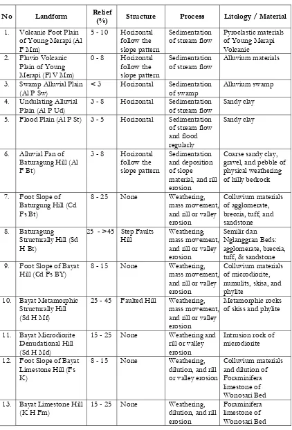
Based on the result of interpretation and analysis of remote sensing data, topo-graphic map, and geological map, include the morphological parameters (slope), structure, process, and materials, which subsequently carried out field check, in fact, in the research area, it is composed of 13 landform units, as presented in Table 1.
The Characteristic of Unconfined Groundwater in the Research Area
No Landform Relief
(%) Structure Process Litology / Material
1. Volcanic Foot Plain of Young Merapi (Al F Mm)
5 - 10 Horizontal follow the slope pattern
Sedimentation of stream flow
Pyroclastic materials of Young Merapi Volcanic
2. Fluvio Volcanic Plain of Young Merapi (Fl V Mm)
0 - 8 Horizontal follow the slope pattern
Sedimentation of stream flow
Alluvium materials
3. Swamp Alluvial Plain (Al P Sw)
< 3 Horizontal Sedimentation of swamp
Alluvium swamp
4. Undulating Alluvial Plain (Al P Ud)
3 - 8 Horizontal Sedimentation of stream flow
Sandy clay
5. Flood Plain (Al P St) 3 - 5 Horizontal Sedimentation of stream flow and flood regularly
Sandy clay
6. Alluvial Fan of Baturagung Hill (Al F Bt)
3 - 8 Horizontal follow the slope pattern
Sedimentation and deposition of slope
material, and rill erosion
Coarse sandy clay, gravel, and pebble of physical weathering of hilly bedrock
7. Foot Slope of Baturgung Hill (Cd Fs Bt)
8 - 25 None Weathering, mass movement, and rill or valley erosion
Colluvium materials of agglomerate, breccia, tuff, and sandstone 8. Baturagung
Structurally Hill (Sd H Bt)
25 - >45 Step Faults Hill
Weathering, mass movement, and rill or valley erosion
Semilir dan Nglanggran Beds: agglomerate, breccia, tuff, & sandstone 9. Foot Slope of Bayat
Hill (Cd Fs BY)
8 - 15 None Weathering, mass movement, and rill or valley erosion
Colluvium materials of microdiorite, numulits, skisa, and phylite
10. Bayat Metamorphic Structurally Hill (Sd H Mf)
25 - 45 Faulted Hill Weathering, mass movement, and rill or valley erosion
Metamorphic rocks of skiss and phylite
11. Bayat Microdiorite Denudational Hill (Sd H Md)
15 - 25 None Weathering and rill or valley erosion
Intrusion rock of microdiorite
12. Foot Slope of Bayat Limestone Hill (Fs K)
8 - 15 None Weathering, dilution, and rill or valley erosion
Colluvium materials and dilution of Foraminifera limestone of Wonosari Bed 13. Bayat Limestone Hill
(K H Fm)
15 - 25 None Weathering, dilution, and rill erosion
Foraminifera limestone of Wonosari Bed Table 1. Landform Units and Its Characteristic in the Research Area
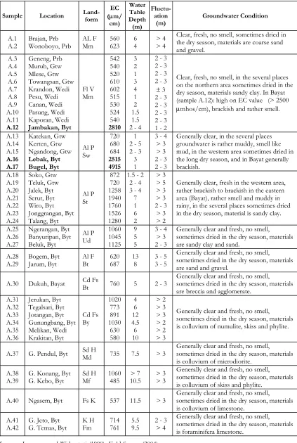
Table 2. Characteristic of the Unconfined Groundwater in the Research Area
Sample Location
Land-form
Groundwater Condition
A.1 A.2
Brajan, Prb Wonoboyo, Prb
AL F
Clear, fresh, no smell, sometimes dried in the dry season, materials are coarse sand and gravel.
A.3
Geneng, Prb Muruh, Gtw Mlese, Gtw Towangsan, Gtw Krandon, Wedi Pesu, Wedi Canan, Wedi Pasung, Wedi Kaporan, Wedi Jambakan, Byt
Clear, fresh, no smell, in the several places on the northern area sometimes dried in the dry season, materials sandy clay. In Bayat (sample A.12): high on EC value (> 2500 µmhos/cm), brackish and rather smell.
A.13 A.14 A.15 A.16 A.17
Katekan, Gtw Kerten, Gtw Ngandong, Gtw Lebak, Byt
Generally clear, in the several places groundwater is rather muddy, smell like mud, in the western area sometimes dried in the long dry season, and in Bayat generally brackish. Jonggrangan, Byt Talang, Byt
Al P
Generally clear, fresh in the western area, rather brackish to brackish in the eastern area (Bayat), rather smell and muddy in rainy, in the several places sometimes dried in the dry season, material is sandy clay.
A.25 A.26 A.27
Ngerangan, Byt Banyuripan, Byt Beluk, Byt
Generally clear and fresh, no smell, sometimes dried in the dry season, materials are sandy clay and sand.
A.28
Generally clear and fresh, no smell, sometimes dried in the dry season, materials are sand and gravel.
A.30 Dukuh, Bayat Cd Fs
Bt 760 5 2 - 3
Generally clear and fresh, no smell, sometimes dried in the dry season, materials are breccia and agglomerate.
A.31
Jerukan, Byt Tegalsari, Byt Jotangan, Byt Gunungbang, Byt Melikan, Wedi Krakitan, Byt
Cd Fs
Generally clear and fresh, no smell, sometimes dried in the dry season, materials is colluvium of numulite, skiss and phylite.
A.37 G. Pendul, Byt Sd H
Md 735 7.5 > 3
Generally clear and fresh, no smell, sometimes dried in the dry season, materials is colluvium of microdiorite.
A.38
Generally clear and fresh, no smell, sometimes dried in the dry season, materials is colluvium of skiss and phylite.
A.40 Ngasem, Byt Fs K 537 11.5 > 3
Generally clear and fresh, no smell, sometimes dried in the dry season, materials is colluvium of limestone.
A.41
Generally clear and fresh, no smell, sometimes dried in the dry season, materials is foraminifera limestone.
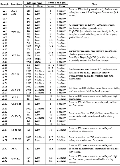
Table 3. Classification of Electric Conductivity and Depth of Water Table in the Research Area
EC (µm/cm) Water Table (m) Sample Landform
Value Class Value Class Note
A.1
Low on EC (fresh groundwater), shallow water table, but there is handicap on fluctuation (> 4 meter). fresh and shallow groundwater.
High EC (brackish) is just met locally in Bayat (maybe related with the genesis of the region, paleo lithoral zone).
A.13
In the western area, generally low on EC and shallow groundwater.
Locally in Bayat, high EC (brackish to saline), especially around the Jombor swamp.
A.18
In the western area low on EC, in the eastern area medium on EC, generally shallow groundwater, and in the western area high fluctuation.
Medium on EC, shallow to medium water table, and sometimes dried in the dry season.
A.28
Low on EC, medium on water table, and high fluctuation.
A.30 Cd Fs Bt 760 Low 5 Shallow Low on EC, shallow water table, and medium on fluctuation.
A.31
Low to medium on EC, shallow to medium on water table, and sometimes dried in the dry season.
A.37 Sd H Md 735 Low 7.5 Medium Low on EC, medium on water table, and medium on fluctuation.
A.38
Low to medium on EC, medium on water table, and medium on fluctuation.
A.40 Fs K 537 Low 11.5 Medium
Low on EC, medium on water table, and medium on fluctuation, sometimes dried in the dry season.
A.41
Low on EC, medium on water table, and high on fluctuation, sometimes dried in the dry season.
Table 4. Chemical Analysis and Classification of Unconfined Groundwater Quality in the Research Area
Groundwater Samples Parameters
Physical Condition: - Colour Ion Concentration:
Na+
Limiting Factors Cl, Ca,
SO4 CaCO3
CaCO3
NH3 NH3 NH3 NH3 NH3 - NH3
Sources: Data Analysis: Langgeng and Widyastuti (1998), and Field Survey (2004)
Table 5. Analysis and Classification of the Hydro-chemical Type of Unconfined Groundwater in the Research Area
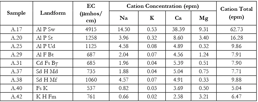
Cation Concentration (epm) Sample Landform
Based on the result of groundwater hydro-chemical type testing in the research area, in fact there were 3 groundwater types, type I (bicarbonate water), type III (evapo-rated water) and type Va (initiation process of connate water).
(a) Type I hydro-chemical is bicarbonate water from calcium and magnesium. This group comprised of sample A.40 and A.42, in which both of them were parts of Foraminifera Limestone Hill unit in Bayat. This groundwater had high characteristic of Ca+Mg and HCO
3
, Na+K content low-medium, diluted compact substance and pH was relatively low. This groundwater is tasteless and has good quality. It can be used as drinking water. This type of groundwater is also met in Fluvio Vol-canic Plain of Young Merapi unit (ex-cept Bayat), Flood Plain unit (ex(ex-cept Bayat), Alluvial Fan of Baturagung Hill unit, and several places in the Baturagung Structurally Hill unit. This is supported by the physical character-istic and its low of EC value.
(b) Type III hydro-chemcal only comprised of sample A.17 and there were also possibly several samples having
rela-tively high EC (> 2500 mmhos/cm). This groundwater is included in evapo-rate water, generally come from shal-low groundwater, high SO
4 content, high Ca+Mg, low Na+K and HCO
3. The groundwater is brackish to salty, even sometimes stink. High SO
4 con-tent mostly over the maximum limit recommended, even sometimes over the maximum limit allowed. Low qual-ity of groundwater generally comes from swamp sedimentation in alluvial plain. Such a condition is clearly met in Allu-vial Swamp Plain unit (in Bayat), asso-ciated with sedimentation environment of ancient sea activities residual in Bayat (Pre-Tertiary era). This ground-water is sulfate or evaporated ground-water, as a result of sedimentation process effect in limestone sedimentation resulting from salty water. High content of SO
4 and Cl causes the groundwater changed into hardness and having low quality, in appropriate for drinking water. (c) Other landform units are generally
in-cluded in Va hydro-chemical type. Most of this group exists in the research area. The groundwater is tasteless groundwa-ter with relatively low on Cl content. This group is marked by the beginning Anion Concentration (epm)
Sample Landform
Cl SO4 HCO3 CO3
Anion Total (epm)
Hidrochemical Type
A.17 Al P Sw 41.97 14.56 34.04 0 90.57 III
A.20 Al P St 2.34 4.66 25.53 0 32.53 Va
A.25 Al P Ud 0.49 0.73 45.72 0 46.98 Va
A.29 Al F Bt 0.55 0.80 19.07 0 20.42 Va
A.31 Cd Fs By 0.29 0.48 41.49 0 42.26 Va
A.37 Sd H Md 0.28 0.36 41.88 0 42.54 Va
A.38 Sd H Mf 0.47 0.75 45.75 0 46.97 Va
A.40 Fs K 0.33 0.24 20.77 0 21.34 I
A.42 K H Fm 0.33 0.67 38.81 0 39.81 I
of cation exchange and the change to connate water. The quality of ground-water is still good and can be used for drinking water, but has to be careful because there is a possibility that cat-ion exchange will continue into salty connate water.
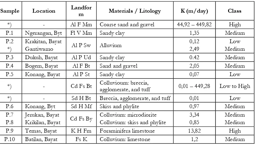
The result data of pumping test in several landform units is analyzed to yield aquifer permeability value data in each compounding material, whose classification can be seen in Table 6. Based on this data, in fact, in the research field, there is also variation of coefficient classification of aquifer permeability, starting from slow to high permeability.
(a) High aquifer permeability coefficient is met in Volcanic Foot Plain of Young Merapi unit of 44,92 to 449,28 m/day, composed of hard sand materials and gravel, and in Bayat Limestone Hill unit
of 13,824 m/day, composed of fora-minifera limestone. The high level of aquifer permeability in both units is caused of its rock characteristic, which relatively has much big pores and many secondary cracks in the limestone, which enables better groundwater sup-ply. The aquifer is able to catch, store, and distribute the water well and in large amount.
(b) Slow aquifer permeability coefficient is met in Swamp Alluvial Plain unit of 1,99 x10⁻⁴ to 0,128 m/day, Flood Plain unit of 0,079 m/day, and Baturagung Structurally Hill unit of 0,0199 m/day. Fine sandy clay materials in ex swamp and river units, and flat morphological condition cause the difficulty for gro-undwater to move, ground is rapidly sa-turated, so that the velocity of ground-water release is relatively slow. Mean-while, as a result of relatively water Table 6. Classification of the Aquifer Permeability in the Research Area
Sample Location Landfor
m Materials / Litology K (m/day) Class
*) - Al F Mm Coarse sand and gravel 44,92 – 449,82 High P.1 Ngerangan, Byt Fl V Mm Sandy clay 1,35 Medium P.2
*)
Krakitan, Bayat
Gantiwarno Al P Sw Alluvium
0,12 2,49
Low Medium
P.3 Dukuh, Bayat Al P Ud Sandy clay 0.42 Medium
P.4 Bogem, Bayat Al F Bt Sand and gravel 2,05 Medium
P.5 Konang, Bayat Al P St Sandy clay 0,07 Low
*) - Cd Fs Bt Colluvioum: breccia,
agglomerate, and tuff 0,01 – 449,28 Low to High *) - Sd H Bt Breccia, agglomerate, and tuff 0,01 Low P.6 Konang, Byt Sd H Mf Skiss and phylite 0,97 Medium P.7
P.8
Jerukan, Bayat
Krikilan, Bayat Cd Fs By
Colluvium: microdiorite Colluvium: skiss and phylite
3,34 0,85
Medium Medium P.9 Temas, Bayat K H Fm Foraminifera limestone 13,82 High P.10 Batilan, Bayat Fs K Colluvium: limestone 1,2 Medium
proof and massive release rock condi-tion, it causes the groundwater difficult to penetrate the rock and the release velocity is very slow in Baturagung Structurally Hill unit.
(c) Other units have medium permeability coefficient as a result of composing ma-terials condition, which relatively in the form of mix between the results of rock tear down from the surrounding hills. This unstable condition, composed of various materials, gives effect to the va-riation of aquifer permeability coeffi-cient value. In general, all of these per-meability coefficient value variations are included in medium permeability class.
Therefore, based on the result of analysis and classification of groundwater characteristic, whose mapping unit is based on landform unit above, finally it can make research area hydromorphology unit. Hydromorphology unit can be used as the base for planning or groundwater develop-ment direction, related to the use for drink-ing water.
Hydromorphology Units of the Re-search Area
Based on the result of landform unit interpretation and the result of unconfined groundwater characteristic measurement in the field, and the result of groundwater quality laboratory testing analysis, in fact, from the 13 types of landform units, it can be resulted 16 type of hydromorphology unit in the research area, as listed in Table 7, and its distribution is presented in Pic-ture 1.
In general, hydromorphology units existing in Bayat have striking unconfined
groundwater characteristic (worse) com-pared to other places in southern Klaten District. Hydromorphology unit of Fluvio Volcanic Plain of Young Merapi in Bayat (Fl V Mm / ECs-t.Dk.As.Va.Ks), is a unit having shallow groundwater characteristic, medium to high of electric conductivity (<1000-2810 mmhos/cm), medium qual-ity of groundwater with the limit of maxi-mum SO
4 and NH3 content, Va type hy-dro-chemical, and medium permeability (±1.356 m/day). High value of electric conductivity value may be affected by the region genesis and sedimentation environ-ment of ancient shallow sea in Bayat, so that the content of ancient sea activities residual is high enough. The shallow of water table is affected by the topography in the form of plain, and groundwater movement from the surrounding is submit-ted in that plain unit. Hydro-chemical type is fresh water, but it was the beginning of cation exchange (Va). Medium permeabil-ity is possible caused by the composing material, various and mixed unsortation (mud, sand, gravel).
Hydromorphology unit of Swamp Alluvial Plain in Bayat (Al P Sw / ECt.Dk.Ar.III.Kr) is the unit having the worst condition for its groundwater. High DHL value makes the groundwater brack-ish to salty, low quality, type III of hydr-ochemical, and slow permeability. The high value of electric conductivity (>2500 mmhos/cm) affecting the low quality is affected by the amount of concentration of diluted substance (Ca, CL, and SO
the surrounding groundwater condition re-cently. Very intensive process of material sedimentation (sandy clay) as a result of relatively frequent flooding in this unit causes worse aquifer condition with slow permeability. Moreover, its morphology, taking the form of basin (lower than the surrounding), muddy and many organic materials included in the sedimentation. This unit is a unit having the most inap-propriate groundwater for the need of drinking water, and it needs more serious
management.
Hydromorphology unit of Flood Plain in Bayat (Al P St / ECs.Dk.As.Va.Kr), is the third unit in Bayat relatively has poor groundwater characteristic, and not good to be used. Unconfined groundwater char-acteristic is almost the same as Fluvio Vol-canic Plain in Bayat, medium value of elec-tric conductivity, shallow groundwater, medium quality, Va type and slow aquifer permeability.
Forum Geografi,
V
ol. 20, No. 2, Desember 2006: 142 - 159
156
Table 7. Hydromorphology Units and Its Characteristic in the Research Area
Landform Water Table
(m)
Limited of Groundwater
Units Remarks
Al F Mm < 1000 (ECr) (Dk) < 7 None **) (Ab) Bicarbonate **) ( I ) 44,928 - 449,28 *) (Kc) ECr.Dk.Ab.I.Kc Al F Mm Medium to high of fluctuation, sometimes well can dry in dry season. Fl V Mm
(beside Bayat)
< 1000
Low fluctuation, generally well does not dry in dry season, dominantly materials are mixed of sandy and clay.
Fl V Mm
Beginning of Connate Water +)
Medium fluctuation, several wells can dry in dry season, and groundwater in several places air is brackish.
Al P Sw (beside Bayat)
< 1000 (ECr)
< 7 (Dk)
Turbidity and Smell (As)
Beginning of Connate Water (Va)
1,99x10⁻⁴ - 2,497 *)
(Kr - Ks)
Al P Sw ECr.Dk.As.Va.Kr-s
Low fluctuation, turbid water, and smell like muddy.
Evaporate Water (III)
0,128 (Kr)
Al P Sw
ECt.Dk.Ar.III.Kr Low fluctuation, brackish to salty. Al P St
(beside Bayat)
< 1000
Medium to high of fluctuation, sometimes wells can dry in dry season.
Al P St
Beginning of Connate Water (Va)
0,079 (Kr)
Al P St ECs.Dk.As.Va.Kr
Low fluctuation, brackish, and smell like muddy.
Medium to high fluctuation, sometimes wells can dry in dry season, and in the several places, water table are deep. Sd H Mf < 1000 - 1060
Beginning of Connate Water (Va)
0,976 (Ks)
Sd H Mf ECr-s.Ds.Ab.Va.Ks
High fluctuation, water table is deep, wells can dry in dry season.
Medium to high fluctuation, water table is deep, wells can dry in dry season. K H Fm < 1000 (ECr) (Ds) > 7 NH3 (Ab) BIcarbonate ( I ) 13,824 (Kc) ECr.Ds.Ab.I.Kc K H Fm High fluctuation, water table is medium to deep, wells can dry in dry season.
The Recommendation of Unconfined Groundwater Use
The recommendation showing the direction of unconfined groundwater use to meet people need for drinking water is based on the following consideration:
(a) groundwater quality class for drinking, and the ease of quality limiting factor management;
(b) groundwater electric conductivity value class and the type of groundwater hy-dro-chemical related to the groundwa-ter genesis;
(c) the level of ease to obtain water re-source based on the water table of groundwater; and
(d) aquifer permeability coefficient class as the estimation base for groundwater availability, and groundwater fluctua-tion as the based of water table change, related to the ease to obtain groundwa-ter in dry season.
Based on those considerations, groundwater unit prioritized to support the need of drinking water of the people is the unit having good groundwater quality (Ab), low of electric conductivity value (ECr), included in the type of bicarbonate or fresh water (type I), easily obtained with simple equipments (shallow water table = Dk) and medium to fast (Ks to Kc) aquifer perme-ability coefficient, allowing smooth move-ment of groundwater as the supplier of groundwater. This priority includes: Fluvio Volcanic Plain units (besides Bayat) and Volcanic Foot Plain unit. The next priority is the unit having good quality (Ab), low to medium electric conductivity (ECr to ECs), included in bicarbonate and fresh water (type I and Va), groundwater is easily ob-tained (shallow to medium groundwater, Dk to Ds), and medium permeability
coeffi-cient (Ks). The obstacle is high enough groundwater fluctuation. Included in it is the Foot Slope of Bayat Hill unit; Alluvial Fan of Baturagung Hill unit, and the Foot Slope of Baturagung unit. The effort to manage the environment to reduce the fluc-tuation of groundwater is using land con-servation and infiltration well system.
The unit not becoming the priority is the unit with medium to low groundwater quality (As to Ar), included the beginning of connate water (type Va) or evaporate water type (type III), medium to high of electric conductivity (ECs to ECt), shal-low to medium groundwater (Dk to Ds), and low to medium aquifer permeability (Kr to Ks). The difficult obstacle is the poor water quality as a result of region genesis and sedimentation environment ex ancient sea (lithoral zone). This includes units ex-isting in Bayat: Flood Plain, Undulating Alluvial Plain, Fluvio Volcanic Plain, and Swamp Alluvial Plain units.
CONCLUSION
(1) Each landform in the research area has variation and distribution of unconfined groundwater characteristic. Therefore, it is true that each landform unit has certain respond to the characteristic and distribution of the unconfined groundwater.
the genesis ex ancient sea activities in the era of Pre Tertiary with shallow sea zone sedimentation environment (lithoral zone), causes the happening of sea water residual trap, so that it is met many brackish or even salty water, high of electric conductivity and low qual-ity (evaporate water).
(3) Based on the analysis of its hydromor-phology unit, thus the main priority of the use of unconfined groundwater is for drinking. This exists in Volcanic Foot Plain of Young Merapi and Fluvio Vol-canic Plain of Young Merapi units, be-sides Bayat. The unit not becoming the priority, related to poor quality and
hy-dro-chemical type of unconfined gro-undwater is the units existing in Bayat. This comprises of: Flood Plain, Undu-lating Alluvial Plain, Fluvio Volcanic Plain of Young Merapi, and Swamp Alluvial Plain units.
ACKNOWLEDGEMENT
Greatest gratitude I say to UGM Re-search Institution that has funded this re-search and great reward is give to my sister M. Widyastuti, who in the beginning be-came the lecturer in Geography Faculty of Gadjah Mada University, together you help in various activities and also this research.
REFERENCES
Ahmed A. Murad, and R.V. Krishnamurthy, 2004. Factors Controlling Groundwater Quality in Eastern United Arab Emirats: a Chemical and Isotopic Approach. Journal of Hydrology in the www.elsevier.com/lacate/jhydrol. Vol. 286. Pages 227-235. Elsevier Appelo, C.A.J. and Postma, D., 1994. Geochemistry, Groundwater and Pollution. A.A. Balkema,
Rotterdam, 536p
Bemmelen, R.W. Van, 1970, The Geology of Indonesia, General Geology of Indonesia and Adjecent Archipelagoes, Vol. IA, 2nd editions, Government Printing Office, the Haque Cartwright, I. And Tamie R. Weaver, 2005. Hydrogeochemistry of the Goulburn Valley Region of the Murray Basin Australia Implikations for Flow paths and Resource Vulnerability. Hydrogeology Journal. Official Journal of the International Association of Hydrogeologists. Volume 13 Number 5-6 October 2005. Pages 752 – 770. Springer Verlag, Berlin, Heidelberg
De Rider, 1972, Hydrogeology of Different Types of Plain, ILRI, Wegeningen
Gabriela-Garcia, M., Margarita-Hidalgo, del V., and Miguel-Blesa, A., 2001. Geochemistry of Groundwater in the Alluvial Plain of Tucuman Province, Argentina, Hydrogeology Journal. Official Journal of the International Association of Hydrogeologists. Volume 9 December 2001. Pages 597 – 610. Springer Verlag, Berlin, Heidelberg
Hadi-Sutomo, 1990, Applied Geology in the Regional Planning in Jiwo Hill and Surrounding of Bayat Region District of Klaten, Tesis, Postgraduate program, Gadjah Mada University, Yogyakarta (in Indonesian language)
Lawrence, A.R., Gooddy, D.C., Kanatharana, P., Meesilp, W., and Ramnarong, V., 2000. Groundwater Evolution Beneath Hat Yai, a Rapidly Developing City in Thailand. Hydrogeolog y Jour nal. Official Journal of the International Association of Hydrogeologists. Volume 8 September 2000. Pages 564 – 575. Springer Verlag, Berlin, Heidelberg
Martinez, D.E., and Bocanegra, E.M., 2002. Hydrogeochemistry and Cation-exchange Processes in the Coastal Aquifer of Mar Del Plata, Argentina. Hydrogeology Journal. Official Journal of the International Association of Hydrogeologists. Volume 10 April 2002. Pages 393 – 408. Springer Verlag, Berlin, Heidelberg
Robert, 1982, Introduction of Structural Geology, John Wiley and Sons, New York
Santosa, L.W., 1995, Unconfined Groundwater Characteristic with Landform Unit Approach in Jiwo Hill of Bayat Region, Thesis, Faculty of Geography, Gadjah Mada University, Yogyakarta (in Indonesian language)
Santosa, L.W., and Widyastuti, 1998, Study of Hidrogeomorphological as Based on Development Planning of Groundwater Resource in South of Klaten District, Report Research, Research Instituion, Gadjah Mada University, Yogyakarta (in Indonesian language)
Soemarto C.D., 1988, Technical Hydrology, Usaha Nasional, Surabaya (in Indonesian language) Sutikno, 1989, Study of Landform to Zoning of Clean Water System in Serang Watershed Kulonprogo, Research Report, Faculty of Geography, Gadjah Mada University, Yogyakarta (in Indonesian language)
Sutikno, 1992, Geomorphological Approach to Unconfined Groundwater Study in Sangiran Hill Area, District of Sragen, Central Java, Research Report, Faculty of Geography, Gadjah Mada University, Yogyakarta (in Indonesian language)
Todd, D.K., 1980, Groundwater Hydrology, John Wiley and Sons, New York
Umar-Asad, Umar-Rashid, and Ahmad, M.S., 2001. Hydrogeological and Hydrochemical Framewrok of Regional Aquifer System in Kali Ganga Sub-Basin, India. Journal on Environmental Geology in the www.proquest.com. Volume 40, February 2001. Pages 602 – 611. Applied Science and Technology Plus