Abstract—Safety, river environment, and sediment utilization are
the elements of the target of sediment management. As a change in an element by sediment management, may affect the other two elements, and the priority among three elements depends on stakeholders. It is necessary to develop a method to evaluate the effect of sediment management on each element and an integrated evaluation method for socio-economic effect. In this study, taking Mount Merapi basin as an investigation field, the method for an active volcanic basin was developed. An integrated evaluation method for sediment management was discussed from a socio-economic point on safety, environment, and sediment utilization and a case study of sediment management was evaluated by means of this method. To evaluate the effect of sediment management, some parameters on safety, utilization, and environment have been introduced. From a utilization point of view, job opportunity, additional income of local people, and tax income to local government were used to evaluate the effectiveness of sediment management. The risk degree of river infrastructure was used to describe the effect of sediment management on a safety aspect. To evaluate the effects of sediment management on environment, the mean diameter of grain size distribution of riverbed surface was used. On the coordinate system designating these elements, the direction of change in basin condition by sediment management can be predicted, so that the most preferable sediment management can be decided. The results indicate that the cases of sediment management tend to give the negative impacts on sediment utilization. However, these sediment managements will give positive impacts on safety and environment condition. Evaluation result from a social-economic point of view shows that the case study of sediment management reduces job opportunity and additional income for inhabitants as well as tax income for government. Therefore, it is necessary to make another policy for creating job opportunity for inhabitants to support these sediment managements.
Keywords—Merapi; sediment; management; evaluation
I.INTRODUCTION
HE meaning of sediment management is generally the human intervention to control sediment discharge. Safety, river environment, and sediment utilization are the elements of the target of sediment management. The priority among three elements depends on stakeholders. Sediment management is called a good management, if the result of the activity will go toward to expected targets. Conversely, if the result goes to opposite direction of the target, the sediment management is not a good management. In this paper, integrated sediment management with considering among three targets is attempted to be developed. A change in an element by sediment management will affect the other two elements.
Jazaul Ikhsan, Civil Engineering Department , University of Muhammadiyah Yogyakarta, Yogyakarta, Indonesia (phone: +62-274-387656; fax: +62-274-387646; e-mail: jazaul.ikhsan@ umy.ac.id).
Masaharu Fujita , Disaster Prevention Research Institute, Kyoto University, Japan (e-mail: [email protected]).
Furthermore, changes in environment, safety, and utilization elements by a sediment management policy will cause a change in a socio-economic condition. This research takes Mount Merapi basin as a selected case study.
II.SEDIMENT PROBLEMS IN MOUNT MERAPI,INDONESIA
Regarding the environment target, people give attention on bed variation, bed material changes, and turbidity. From the safety point of view, sediment is managed in order to secure people and assets from sediment disasters, riverbed stabilization, riverbank protection, and sedimentation control in a reservoir. On the other hand, people also use sediment as resources such as construction material, agriculture land, and sand for beach.
A.Sediment Management Frameworks
Regarding sediment problem, there are three options to face the sediment disaster. Kelman and Mather [4] have developed the option frameworks. The first option against the sediment disasters is to do nothing. It means no sediment management.If no sediment management, disaster will occur and give negative impact for social, economical, and environmental aspects in the area where the disaster happens.The second option is to protect a society from the sediment disasters by sediment disaster mitigation. To reduce the negative impacts of the excess sediment discharge, commonly, sabo dams are used to protect a society and assets in downstream from sediment disasters. The dams can capture almost all transported sediment from upstream and the sediment is deposited on their upstream side, finally, riverbed degradation takes place in downstream area. The second option will give positive impacts for socio-economic condition, but it still causes negative impacts for environment. The last option is live with disasters. Livelihoods are integrated with sediment threats and opportunities with considering sustainability of environment.
B.Sediment Disasters in Mount Merapi, Indonesia
Mount Merapi located in Yogyakarta, Indonesia is one of the most active volcanoes in Indonesia. It has erupted 41 times in the last 200 years including 15 major eruptions. It generally erupts every 3 years with a major eruption every 9 years. Its eruptions have produced large amounts of volcanic material as ash falls, lava, and pyroclastic flows. Mount Merapi has been producing a huge amount of sediment. Produced sediment deposited on the slopes of Mount Merapi and partly transported by water flow to the downstream areas through the tributaries that originate in the volcano. The deposited sediment has been causing many sediment disasters, and threatening local residents. Pyroclastic flows and debris flows were happened very often on the slopes of Mount Merapi. The pyroclastic flows
Jazaul Ikhsan, Masaharu Fujita
A New Approach for Effect Evaluation of
Sediment Management
T
have caused tremendous damages around Mount Merapi. A typical phenomenon of pyroclastic flow of Mount Merapi is a pyroclastic flow accompanied by glowing cloud. In Mount Merapi area, debris flow starts on the upper slope between the elevations of 1,000 and 2,000 m. Debris flows have frequently happened just after eruptions because pyroclastic flows pile up a huge quantity of loose sediments and ashes in the river basin of the volcano. The total number of the recorded debris flows from 1931 to 1996 is more than 500 times [2].
C.Sediment Resources
On the other hand, the sediment is important resources for local people. The sediment in Mout Merapi has good quality and is popular as construction material, so that people use it as a resource through sand mining activities. The sand mining activities have given some advantages for rural/local people and local governments. Ban of sand mining damages the economic condition of both local people and local governments.
The sand mining activities in the area have become very active because of the following reasons. First, the high price of the sand is so attractive. The cost of transportation of sand from the mountain to Semarang city is 15,000 rupiah/m3, while its sales price is 100,000 rupiah/m3. Second, the sense of security provided by the sabo facilities has encouraged people to use the land and other resources as well as the deposited sand in this area. Sand mining activities can provide additional income during the off-season of agriculture. Third, poverty and unemployment have forced local people to get involved in sand mining activity as individual miners or laborers for a private sand mining company.
III. AMETHOD FOR EVALUATING OF SEDIMENT
MANAGEMENT
Objectives of sediment management in Mount Merapi generally consist of three main components, namely controlling sand mining, riverbed stabilization and the disaster mitigation. Effect of sediment management on socio-economic aspect will be evaluated based on these three main components and environment aspect.
A. Sand Mining Control
Effect of sediment management on socio-economic conditions are evaluated by changes in job opportunity, additional income of inhabitants, sand mining tax of local governments, infrastructure development and so on. In this paper, changes in job opportunity and sand mining tax are used to evaluate the effect of sediment management on this aspect. Effect of sand mining control on socio-economic are divided into 3 parts, namely: a) Effect on local people, b) Effect on distributor/company and c) Effect on local government.
B.Riverbed Stabilization
The severe riverbed degradation has taken place in the lower Progo River, resulting in instability of the public infrastructure, as bridges and irrigation intakes. Effect of sediment management on river structures is calculated by estimating the
risk of river structures. For a bridge structure, the risk is discussed from the three parameters, namely P1(the risk of the foundation function), P2 (the risk of the pier function) and P3 (the risk of the bridge function). The value of riverbed variation (∆z) is negative if bed degradation occurs and positive if bed foundation depth. Critical condition is achieved if the values of
P1, P2 and P3, are equal to -1. If P1, P2 and P3are greater than -1, it shows that the bridge is in a safe condition. If P1is equal to -1, it means that the foundation tends to collapse due to river degradation. P2 is equal to -1, it means that piers are completely buried by sediment; consequently the pier function is in a crucial condition. Water will flow over the bridge, if P3 is equal to -1. means the structure is in a safe condition.
To calculate the risk degree of an irrigation intake, a set of the following equations is proposed. For an irrigation intake structure, the risk is discussed from the two parameters, namely
P4 (the risk of sedimentation) and P5 (the risk of water intake function). If P4 is equal to -1, it indicates that sedimentation starts to take place in the irrigation channel. The irrigation intake has problem on serving to agriculture land because water cannot enter to the irrigation channel, if P5 is equal to -1. In this paper, the risk degree of each of the parameter can be obtained using equation as follows.
b
where Hbis the height from the riverbed to the crest of channel and Hwis the water depth above the crest of channel. The risk degree of an irrigation intake is calculated using the equations as follows.
C.Volcanic Disaster Mitigation
Effect of sediment management on socio-economy also can be evaluated using the benefit associated with disaster mitigation. Although, the method how to calculate the benefits directly is difficult. The sand mining management can be used as a part of the volcanic disaster mitigation against debris flow, so that the cost of sabo facilities can be saved by removing sand from river channels and increasing the capacity of sediment reservoirs. Moreover, controlling the excess sediment discharge
by sand mining management can reduce the damage caused by debris flows. It is another benefit from controlling sand mining activity.
D.Environment Aspects
Sediment size is the one of the most important factor to affect on habitats for fauna and flora. The influence of sediment management on environmental change is measured by change of the riverbed material. The riverbed material change is indicated by change in the average diameter of the riverbed material.
IV. THE CASES OF SEDIMENT MANAGEMENT
The sediment management shown in Table 1 will be used as case studies of sediment management that to be evaluated from socio-economic and environment aspects. The simulation is carried out using the averaged geometric and hydraulic characteristic values of the lower reach of the Progo River.The calculation length is 30 km. Normal water depth is used for the downstream boundary conditions. The water discharge is the annual average discharge (83.1m3/s); the river width is the average river width (200 m); the initial slope is 0.0015, and the bed material is treated as non-uniform sediment with the mean diameter of 1 mm.
In Case 1, the bed variation was simulated under natural conditions, i.e., without management or sand mining. The sediment management by sand mining activity was considered in Case 2. In Case 2a, the volume of sand mined was the same as the annual average of sediment production volume. In Case 2b, the volume of sand mined was 50% of the annual average of sediment production volume. The variation in the riverbed was simulated considering the installation of channel works (groundsills) and sand mining in Case 3. The height of each groundsill was 2.7 m, and the longitudinal interval between groundsills was 9 km. In Cases 3a and 3b, 100% and 50% of the annual average of sediment production volume was mined, respectively.
TABLEI
SCENARIOS OF PROPOSED SEDIMENT MANAGEMENT
Cases Sediment Control Structure Sand mining volumes (m3/year)
1 No No
2.a No 1.44x10⁶
2.b No 0.72x10⁶
3.a Groundsills 1.44x10⁶
3.b Groundsills 0.72x10⁶
V.RESULT AND DISCUSSION A.Socio-Economical Aspects
Effect of sand mining control on socio-economic of local people will be evaluated by changes in job opportunity and additional income of inhabitants. The data presented by Directorate General of Water Resources, DGWR [3], are used as the initial data for analysis.
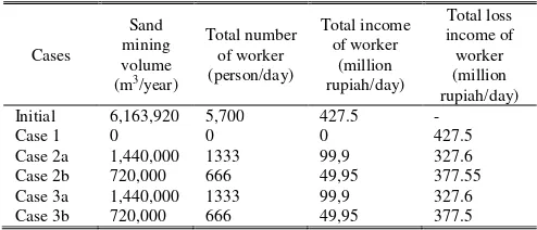
The number of sand miner was estimated at 21,022 persons/day, and the produced sand mining volume was about 25,683 m3/day. If the workable day is assumed 20 days/month, the annual sand mining volume is estimated at 6,163,920 m3/year. It means one sand miner produces 1.22 m3/day. If all sediment production flows down into lower area, such as in the Case 1, it means that sand mining should be prohibited totally. Assuming the number of sand miner in every day is constants, this condition in the Case 1 will cause the loss of job opportunity for inhabitant to be estimated at about 21,022 persons/year. According to Aisyah [1], the price of sand in Mount Merapi basin is about 20,000 rupiah/m3. It means the total loss of daily income of inhabitants is approximately 512 million rupiah/day. The total loss of daily income for every case of proposed sediment management is shown in Table 2. In the Cases 2a and 3a, the loss of job opportunity for local people is small compared with the other cases. Loss of job opportunity of both cases each year is 16,104 people. The total loss of daily income of inhabitants is about 392 million rupiah/day. The loss of job opportunity in the Cases 2b and 3b every year is 18,567people and the total loss of daily income of inhabitants is estimated at 452 million rupiah/day. From Table 2, it indicates that the sand mining activity in Mount Merapi is important for local people from socio-economic aspect. If the government of Indonesia plans to regulate sand mining activity, the most important one is how to provide an alternative job for them.
TABLEII
TOTAL LOSS OF DAILY INCOME OF INHABITANTS
Cases
Sand mining volume (m3/year)
Total number of sand
miner (person/day)
Total income of local
people (million rupiah/day)
Total loss income of local people (million
rupiah/ day)
Initial 6,163,920 21,022 512 -
Case 1 0 0 0 512
Case 2a 1,440,000 4,918 120 392
Case 2b 720,000 2,459 60 452
Case 3a 1,440,000 4,918 120 392
Case 3b 720,000 2,459 60 452
Sand mining control influence not only for local people/sand miner, but also for transportation company/distributor of sand. Generally, workers of one truck with volume of 4.5 m3 consist of driver and co-driver. If the current situation of sand mining is maintained, it needs about 5,700 unit trucks a day for transporting sand. Here, we assumed that one truck can services 2 times a day, so that the sand mining activity requires 2,850 trucks with 5,700 workers. Therefore, if the sand mining management will be applied, it will reduce the number of the transportation workers. For example, the sediment management in the Case 1 will cause the loss of job opportunity for 5,700 workers/day. The number of the loss of the job opportunity for driver/co-driver and truck for case studies presented in Chapter 3 is shown in Table 3. If we assumed that daily income for driver/ co-driver is 75,000 rupiah, the lost of potential income in the Case 1 is 427.5 million rupiah.
-1.5 sand mining in Mount Merapi tends to be active.
TABLEIII
TOTAL LOSS OF DAILY INCOME OF DRIVER/CO-DRIVER
Cases
The effect of sediment management on local government can be evaluated by tax income. By year 1999, the sand mining tax income of the local governments in the surrounding Mount Merapi basin is about 1,014 million rupiah. If we assume that the relationship between the sand mining tax and sand mining volume is linear, the lost of tax income of local government is described as follows. In the Case 1, the loss of tax income is estimated at 1,014 million rupiah/year. In the Cases 2a and 3a, the loss of tax income is about 777.1 million rupiah/year. For the Cases 2b and 3b, the loss of tax income is about 895.5 million rupiah/year.
B.Safety Aspects
The sediment management gives impacts in the upper area and lower area. In the Case 1, the riverbed along the lower Progo River can be stabilized by sediment supply from Mount Merapi. However, due to no groundsill installation in the lower Progo River, the riverbed degradation cannot be solved immediately. Therefore, the sediment management in the Case 1 has not given the positive impact on socio-economic of inhabitants in the both districts. In the Cases 2a and 2b, the riverbed degradation occurred in the lower Progo River, so that the both managements will cause the current situation of riverbed degradation to be worse. From the interest of people in the lower Progo, it is necessary to overcome the riverbed degradation in the area soon, so that the stability of main infrastructure can be maintained. Hence, the groundsill installation is one method to stabilize and against riverbed degradation in the lower Progo. Therefore, the sediment management using groundsills, such as the Cases 3a and 3b, is most reasonable to solve current situation of the riverbed degradation in the lower Progo. Moreover, benefit associated with riverbed stabilization in the downstream area is benefit associated with bridge protection. However, sometimes the benefit is difficult to be quantified exactly. The benefits consist of lost cost by detour due to bridge collapse and cost for reconstruction. Hence, the stability of bridges and irrigation water intakes are important.
The effect of sediment management on river facility structures will be investigated at 2 points, namely at 30 km, and 2 km from the downstream boundary end. The two river facility
structures, namely bridge and water irrigation intake are used as case studies. Figures 1 and 2 show the effect of sediment management on the parameters P1, P2, and P3; and on the risk degree of the parameters P1, P2, and P3 at point 30 km upstream from downstream boundary end, respectively. From the figure, it indicates that the values of all parameters are greater than -1. It describes that no case gives unsafe conditions to the bridge structure. However, the Cases 2a, 2b, and 3a require attention because of the risk of the foundation function tends to increase as shown in Figure 2. The risks of the pier and bridge functions have a tendency to enlarge in the Cases 1 and 3b. However, changes in both parameters are not so fast. The similar conditions to the point 30 km also take place in the point 2, as shown in Figures 3 and 4. However, the Case 3b gave the smallest impact on a bridge structure than the other cases.
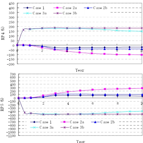
The risk of sedimentation (P4) and water intake function (P5) at point 30 km upstream from downstream boundary end are shown in Figure 5. Figure 5 shows the value of parameter P4 for the Case 1 is greater than -1. It means that if sediment management is conducted as the Case 1, the sedimentation in the irrigation channel will take place. Figure 5 also shows that the Cases 2a, 2b, 3a, and 3b have problems in the water intake function. Under this condition, the value of parameter P5 is greater than -1. However, the problem in the water intake function for the Case 3b can be solved after 2 years due to the sediment supply from the upper area.
Fig. 1 Effect of sediment management on the parameters P1, P2, and P3; at 30 km from downstream boundary end
-100
Fig. 2 Effect of sediment management on risk degree of the parameters P1, P2, and P3; at 30 km from downstream boundary end
Fig. 3 Effect of sediment management on the parameters P1, P2, and P3; at 2 km from downstream boundary end
Fig. 4 Effect of sediment management on risk degree of the parameters P1, P2, and P3; at 2 km from downstream boundary end
Fig. 5 Effect of sediment management on the parameters P4 and P5; at 30 km from downstream boundary end
In a 10-year period, the risk degree of sedimentation for the Case 1 is estimated at 400%, as shown in Figure 6. The sedimentation problem is also found for the Case 3b, although the risk degree of the sedimentation in the Case 3b is not so severe compared with the Case 1. Meanwhile, the risk degrees of the water intake function for the Cases 2a, 2b, and 3a tend to increase. Hence, the Case 3b is the most reasonable of sediment
-200 management from this point of view. Figure 7 shows that the
sedimentation in the irrigation channel takes place in the Cases 1, 3a, and 3b. In the Cases 3a and 3b, the riverbed aggradation is caused by the groundsill installation, so that the riverbed elevation at this point increases. Meanwhile, the riverbed aggradation in the Case 1 is due to sediment supply from the upper area. Figure 7 also describes that water cannot enter to the irrigation channel due to degradation problems in the Cases 2a and 2b. However, the risk degrees of both parameters tend to decrease when the locations are near downstream boundary end, because degradation or aggradation in a downstream reach channel is smaller than in an upper downstream reach channel, as shown in Figure 8.
Fig. 6 Effect of sediment management on risk degree of the parameters P4 and P5; at 30 km from downstream boundary end
Fig. 7 Effect of sediment management on the parameters P4 and P5; at 2 km from downstream boundary end
Fig. 8 Effect of sediment management on risk degree of the parameters P4 and P5; at 2 km from downstream boundary end C.Environmental Aspects
Figure 9 shows the riverbed material changes at the observed locations. At the 30 km upstream from the downstream boundary end, change of the riverbed material in the Case 1 is not so big, the mean diameter changes from 1 mm to 2 mm, due to the impact of sediment supply from upstream. In the Cases 2a and 3a, the mean diameter of riverbed material changes from 1 mm to 7 mm. It indicates that an armor layer has been formed at this point.
Fig. 9 The riverbed material changes at the observed locations
0
In the Case 2b, the mean diameter of riverbed material changes fast during the half-first year from 1 mm to 2.25 mm, then the mean diameter does not change in the following years. As a similar condition to the Case 2b, the mean diameter of riverbed in the Case 3b material also changes fast during the first year from 1 mm to 2.22 mm, then the mean diameter does not change in the following years. The result shows that the sediment supply from the upstream can be used to maintain the quality of riverbed material. Without the sediment supply, the riverbed material tends to be coarser.
At the point 2 km, the mean diameters of riverbed material in most cases are not change significantly, except in the Case 2a. In the Case 2a, the riverbed material tends to be coarser due to no sediment supply from the upstream. In the Case 3a, the finer sediment will be deposited at this point due to the effect of installed groundsill, so that the mean diameter at this point to be finer than that at the other points. However, the mean diameter in the Case 3a tends to increase.
VI. CONCLUSION
Local people have large opportunity to get job as sand miners and local governments get an additional tax, if the present sediment management is maintained. However, the sediment management will give serious negative impacts on environment and safety aspects. To overcome the environment and safety problems, some cases of sediment management are proposed. As a result, job opportunities for local people and additional revenue for local government decrease. It means that the cases of sediment management tend to give the negative impacts on sediment utilization. Therefore, it is necessary to make another policy for creating job opportunity for inhabitants to support the cases of sediment management. However, the sediment management will give positive impacts on two elements, namely safety and environment.
ACKNOWLEDGMENT
The authors are gratefully thank to the Indonesian Government and University of Muhammadiyah Yogyakarta, Indonesia for having given the opportunity and supports for this research, and to the Japanese Government through Monbukagakusho for providing the funding during research.
REFERENCES
[1] S. Aisyah, “Economical potency of sand mining on the Gendol River”, Thesis presented to Gadjah Mada University, Indonesia, 2008, unpublished
[2] Directorate General of Water Resources (DGWR), Ministry of Settlement and Regional Infrastructure, Republic of Indonesia ,”Review master plan study on Mt Merapi, supporting report [B] volcanic disaster”, 2001, unpublished
[3] Directorate General of Water Resources (DGWR), Republic of Indonesia , “Review master plan study on Mt Merapi. supporting report [C] regional development and sustainable sand mining”,2001, unpublished [4] I. Kelman,, and T.A. Mather, “Living with volcanoes: the sustainable
livehoods approach for volcano-related opportunities”, Journal of Volcanology and Geothermal Research, Vol. 172, pp.189-198.