74:9 (2015) 161–167 | www.jurnalteknologi.utm.my | eISSN 2180–3722 |
Jurnal
Teknologi
Full Paper
S
YNCHRONIZATION OF
C
OMPASS
M
ODULE WITH
P
RESSURE AND
T
EMPERATURE
S
ENSOR
S
YSTEM FOR
A
UTONOMOUS
U
NDERWATER
V
EHICLE
(AUV)
Mohamad Haniff Harun
a*, Mohd Shahrieel Mohd Aras
b, Mohd
Farriz Md. Basar
a, Shahrum Shah Abdullah
c, Khalil Azha Mohd
Annuar
aa
Department of Electrical Engineering, Faculty of Technology
Engineering, Universiti Teknikal Malaysia Melaka, Hang Tuah Jaya,
76100 Durian Tunggal, Melaka, Malaysia
b
Underwater Technology Research Group (UTeRG), Faculty of
Electrical Engineering, Universiti Teknikal Malaysia Melaka, Hang
Tuah Jaya, 76100 Durian Tunggal, Melaka, Malaysia
c
Department of Electric and Electronics, Malaysia-Japan
International Institute of Technology, Universiti Teknologi Malaysia,
International Campus Jalan Semarak, 54100 Kuala Lumpur,
Malaysia
Article history Received
13 March 2015
Received in revised form
14 April 2015
Accepted
15 June 2015
*Corresponding author
Graphical abstract
Abstract
This paper describes the synchronization of compass module with pressure and temperature sensor system for an Autonomous Underwater Vehicle (AUV). In general this project is the result of a combination of existing technology for underwater sensory to produce a complete system that aims to identify the position of the AUVs based on AUV degree of freedom. This can be done with the help of compass module that can find and order the AUV is moving at a fixed angle. This created a system that aims to obtain data on pressure and temperature in the AUV. Not only that, the project also aims to prove that the relationship between pressure and depth of the water and the relationship between pressure and temperature. All data gathered is capable of helping in the preparation of an AUV that can accommodate high pressure according to the depth to destination.
Keywords: Compass module, pressure sensor, temperature sensor
Abstrak
Kertas kerja ini menerangkan keseragaman modul kompas dengan tekanan dan sistem sensor suhu untuk Autonomous Underwater Vehicle (AUV). Secara umumnya projek ini adalah hasil daripada gabungan teknologi yang sedia ada untuk deria dalam air untuk menghasilkan satu sistem yang lengkap yang bertujuan untuk mengenal pasti kedudukan AUVs berdasarkan darjah kebebasan AUV. Ini boleh dilakukan dengan bantuan modul kompas yang boleh mencari dan mengarahkan AUV itu sedang bergerak pada sudut yang tetap. Ini mewujudkan satu sistem yang bertujuan untuk mendapatkan data pada tekanan dan suhu di AUV tersebut. Bukan itu sahaja, projek ini juga bertujuan untuk membuktikan bahawa hubungan antara tekanan dan kedalaman air dan hubungan antara tekanan dan suhu. Data yang dikumpul mampu membantu dalam penyediaan satu AUV yang boleh menampung tekanan yang tinggi mengikut kedalaman ke destinasi.
Kata kunci: Modul kompas, sensor tekanan, sensor suhu
1.0 INTRODUCTION
Throughout the history, navigation system formerly is a very rare system in the past few decades because of its specialty in determining location and as guidance to go anywhere but it was tremendously grown in
today’s world. The concept of this navigation system is
drawn since the beginning of time; mankind has been trying to figure out dependable way to know where they are and to guide them from one place to another [1]. This system is designed and built and is operated instead of maintained by the United State Department of Defense under its NAVSTAR satellite program in 1973 [2]. In 1978, the system is firstly used in US military to carry the Polaris nuclear missile by six
satellites. By mid 1990’s the system is fully operated
with up to 24 satellites. Since it became fully operational on April 27, 1995, navigation system has become a widely used aid to navigation worldwide, and a useful tool for map-making, land surveying, commerce, scientific uses, tracking and surveillance, and hobbies such as geocaching. Also, the precise time reference is used in many applications including the scientific study of earthquakes and as a required time synchronization method for cellular network protocols such as the IS-95 standard for CDMA [3]. From the benefits of this very sophisticated technology, a navigation system can be developed in order to have the clearer along the desired path. Normally in navigation system, it involves a reference point which calls the waypoints. These waypoints are set by the diver or the person who needs to know her or his direction and then, the navigation process is taking the part to navigate the person to the set waypoints [4-5]. From its definition, navigation is the process of planning, reading and controlling the movement of a craft or vehicle from one place to another. This former Latin word use is also give the
meaning as “to move” or “to direct”. Thus, with some
research and development also with the use of other device, navigation system can be used as a medium to navigate a craft or vehicle for a wide variety especially in navigation system [6].
Besides all the sophisticated technologies in the system, it still has a major lack which is land navigation cannot be applied directly for underwater navigation even the satellite being used since the terrain under the water is not as on land. The fact is underwater cannot transmit any compass module signal and thus, some modification need to be done to navigate the
Autonomous Underwater Vehicle (AUV). The
underwater vehicle such as submarine also needs the navigation so that its location can be known. As we know, it is very hard to know the location of the vehicle when it is under the water, thus in such instances, if there is any emergency cases, the vehicle cannot be tracked and will not be able to get some help from people outside. This project is to reconcile this problem by addition of the barometric pressure sensor to synchronize with the compass module to be able to detect the location of the AUV when the AUV is above the sea level. For the time being, our world is already
have Predator ETA that is used in military section to get a clear view what is happening in some country. For example, film Transformer used this tiny airship to determine what happen in Qatar before sending reinforcement to support their man. In this project, the
objectives are to develop an Autonomous
Underwater Vehicle with a navigation system to help in military section to do an investigation underwater as same as Predator ETA that being used as an airship spy. The underwater research group from Faculty of Electrical Engineering, Universiti Technical Malaysia Melaka (UTeM) known as Underwater Technology Research Group, UTeRG was developed three types of an AUVs such as Underwater Remotely Operated Vehicle (ROV), Autonomous Underwater Vehicle (AUV) and Underwater Glider (UG) but this application more focused on AUV application.
A pressure sensor measures pressure, typically of gases or liquids. Pressure is an expression of the force required to stop a fluid from expanding, and is usually stated in terms of force per unit area [7]. A pressure sensor usually acts as a transducer; it generates a signal as a function of the pressure imposed. For the purposes of this article, such a signal is electrical. Pressure sensors are used for control and monitoring in thousands of everyday applications. Pressure sensors can also be used to indirectly measure other variables such as fluid/gas flow, speed, water level, and altitude [8-12]. Pressure sensors can alternatively be called pressure transducer, pressure transmitter, pressure
sender, pressure indicator and piezometer,
manometer, among other names [13]. The HMC6352 integrates Honeywell's patented two-axis magnetic sensor with the required analog and digital support circuits for heading computation [14]. For the ultimate in electronic functionality, this innovative electronic compass provides an electronic compass function using two-axis magnetic field sensing. Honeywell's digital compass combines the sensor elements and all the processing electronics in a 6.5mm square
package to satisfy smaller, next generation
applications. Aimed for low power battery operation on OEM printed circuit boards, the HMC6352 uses an I2C digital interface slaved to the manufacturer's microprocessor to transfer compass heading data. Heading update rates from 1 to 20Hz are selectable.
2.0 METHODOLOGY
In this methodology part, it will focus on procedure that will take place after the research has been done.
It’s included software and hardware part that being
this AUV is tested inside the water to make sure the software and hardware is functioning very well. The barometric pressure will detect pressure around the AUV and send the data to LCD display via PIC 16F876A. The receiver acts as a switch to switch on the GPS when pressure is low and switch off when pressure is high. Lastly, this project of Relating Pressure and Temperature with Collaborating to the Depth of the
Water is done.
Figure 1 Flow chart of combination of hardware and software
development
2.1 PIC Microcontroller Start-up Kit
In this project, PIC microcontroller start-up kit is used to connect the compass module, capacitive sensor and barometric pressure sensor to combine it and form a main PIC board as a main controller. This board consists with PIC 16F876A that is used as a memory of the board. This board is designed perfectly fit for 40 pins 16F and 18F PIC that consists of all 33 pins (I/O) that are nicely labeled to avoid miss connection. This item developed with RS232 (serial) hardware on board for allowing alternative method to load program easily via boot loader but there is a fastest way by using UIC00A that can load the program in less than 5 seconds. The development of this board is complete with 5V voltage regulator, 20MHz crystal oscillator, rest button, programmable push button, RS232 hardware for serial communication to PC, connector for UIC00A, on/off switch for main power, DC adaptor socket s power input and all the necessities to eliminate difficulties in using PIC. This item can be shown in Figure 2 and the label of all components in Table 1.
Figure 2 Board layout [2]
Table 1 Label and function of PIC
2.2 PR22 Board
After complete researching about all the components used in this project, the PIC microcontroller start-up kit, barometric pressure sensor, capacitive sensor and compass module is combined to make one PIC board acts as a main controller in this project. This PIC board will receive signal from barometric pressure sensor and send data to LCD display in order to get a data about pressure and temperature. The PR22 board will be immersed in the 3 different medium which is tap water, hot water and cold water. This board is design to
configure pressure, temperature and also
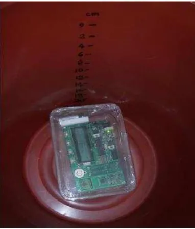
capacitance in surrounding. Figure 3(a) shows the PIC board before combining all the components and Figure 3(b) shows the result after combining all the components used. Figure 4(a) shows the experiment setting for depth while Figure 4(b) shows the PR22 board will be set up for experiment and Figure 4(c) shows the experiment on conducting for depth.
Figure 3(b)PCB circuit board (PR22)
Figure 4(a) Experiment setting for depth
Figure 4(b) PR22 board will be set up for experiment
Figure 4(c) PR22 Board was Immersed in the tap water
3.0 RESULTS AND ANALYSIS
After complete researching about all the components used in this project, the PIC microcontroller start-up kit, barometric pressure sensor, capacitive sensor and compass module is combined to make one PIC board acts as a main controller in this project. This PIC board will receive signal from barometric pressure sensor and send data to LCD display in order to get a data about pressure and temperature. The PR22 board will be immersed in the 3 different medium which is tap water, hot water and cold water. This board is design to
configure pressure, temperature and also
capacitance in surrounding. Figure 5 shows the process flow in order to obtain the relationship between pressure and depth for AUV.
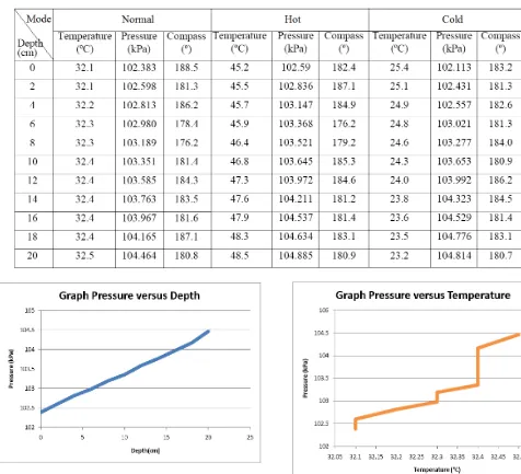
Based on the data obtained, 3 analyses are to
determine the relationship between pressure,
temperature and depth. Three testing are conducted for different temperature modes such as normal, hot and cold water temperature. For normal water the range of temperature about 32.1-32.5°C ,hot water that has a range temperature about 45.2-48.5°C , and cold water that has a range temperature about 25.4-23.8°C. Data are taken based on the experiment carried out in a bucket that has to 20 cm by using different water temperature as shown in Table 2. Data were recorded every 2 cm depth PR22 immersed board.
Table 2 Experiment data Using three modes water condition
Figure 5 Relationship between pressure and depth
Figure 6 Relationship between temperature and depth
Figure 7 Relationship between pressure and temperature
Figure 8 Graph pressure versus depth for all testing method
Figure 9 Graph temperature versus pressure for all testing
method
Figure 9 shows the PR22 board tested (based on temperature and pressure data) according to the experiment 1, 2 and 3 carried out with different mediums. The pressure related to the depth of the water according to the pressure equation but temperature has nothing to do with the pressure and depth. The objective of this project is to synchronizing the compass module with pressure and temperature sensor. The results of this project show that the direction each times the pressure and temperature data being recorded. So, we can detect the position of the AUV by reading the degree from the compass module and its can be as one of the medium as a navigation for AUV.
This AUV is completed with intelligent navigation system where it can be used as a navigator to find out the position of the AUV. In this project, this AUV can be located by move it up above the water surface. So, barometric pressure sensor detects low pressure and send the data to PCB circuit board (PR22) and it send data to LCD display. This LCD display acts as a screen to display value while it receives signal low pressure and compass module detect the location of the AUV. As a result, the AUV location can be detected. In
military section, this AUV can be used as guidance for doing investigation underwater and to prevent from using manpower that will cause them a dangerous situation. Not only that, this AUV called as a guardian in the sea because it can be a detector from any kind of situation in the sea.
Figure 10 Illustration of compass module
This Autonomous Underwater Vehicle is completed with intelligent navigation system where it can be used as a navigator to find out the position of the AUV. In this project, this AUV can be located by move it up above the water surface. So, barometric pressure sensor detects low pressure and send the data to PCB circuit board (PR22) and it send data to LCD display as shown in Figure 10. This LCD display acts as a screen to display value while it receives signal low pressure and compass module detect the location of the AUV. As a result, the AUV location can be detected. In military section, this AUV can be used as guidance for doing investigation underwater and to prevent from using manpower that will cause them a dangerous situation. Not only that, this AUV called as a guardian in the sea because it can be a detector from any kind of situation in the sea.
4.0 CONCLUSION
be able to survive at high pressure and temperature. Starting from the problem statement encounter by some application in determining pressure and temperature relationship, this project will be the one of the system that can be implemented in Autonomous Underwater Vehicle (AUV) process. All the methods carried must be recorded based on the methodology planned, and all the necessary procedures are followed to achieve the objective upon completion. By doing the troubleshooting process or project execution, many arising problems can be solved through some innovation made from time to time. This project combines some of the useful technologies to develop a new system for ease of usage in underwater to determine pressure and temperature at surrounding of AUV. Not only that, this system can help the AUV to recognize its direction by using the compass module.
As the suggestions, this project can help many ways in the military section such as a tracker for any kind of situation happen in the sea. Not only that, it also can help from preventing using manpower in order to explore something blow the water surface. Last but not least, this project offers any kind of tracking for an Autonomous Underwater Vehicle (AUV) for military usage and for any kind of investigation needed below the water surface. To implement this project in order to improve its performances, vibrator sensor is added into this project. This sensor able to sense vibrates around this AUV and directly sends the data to main controller board to switch on the GPS. This sensor acts like an alert system to make sure that there is a danger situation happens to the AUV. So, the GPS detect that the AUV is in danger situation
Acknowledgement
We wish to express our gratitude to honorable University, Universiti Teknikal Malaysia Melaka (UTeM) and Universiti Teknologi Malaysia (UTM) especially for Underwater Technology Research Group (UTeRG), Centre of Research and Innovation Management (CRIM) and to both Faculty of Electrical Engineering, Faculty of Engineering Technology from UTeM and UTM to give the financial as well as moral support for complete this project successfully.
References
[1] Farrel, J. A., and Barth, M. 1999. The Global Positioning System & Inertial Navigation. United State: McGraw Hill. [2] Neitz, M. and Neitz, J. 2000. Molecular Genetics of Color
Vision and Color Vision Defects. Archieves of Ophthalmology. 63(2): 232-237.
[3] Brettel, H. and Vienot, F. 2001. Color Display for Dichromats, Proceeding of SPIE on Color Imaging. 4300: 199-207. [4] Cytron Technologies, Incorporation. 2007. Compass Module
(HMC6352) and Capacitive Sensor (AD7746). Malaysia. [5] L. K. Baxter. 2000. Capacitive Sensor. Retrived July 20, 2000. [6] Julio Rosenblatt, Stefan William and Hugh Durrant-White.
2006. Behavioured Based Control for Autonomous Underwater Vehicle. University of Sydney, Australian Centre for Field Robotics. July 2006.
[7] John Folkesson, Jacques Leederkerken, Rob Williams, Andrew Patrikalakis and John Leonard. 2008. A Feature Based Navigation System for an Autonomous Underwater Robot. Springer Tracts in Advanced Robotics. 42: 105-114. [8] Mohd Aras, Mohd Shahrieel and Abdullah, Shahrum Shah
and Shafei, Siti Saodah. 2012. Investigation and Evaluation of Low cost Depth Sensor System Using Pressure Sensor for Unmanned Underwater Vehicle. Majlesi Journal of Electrical Engineering. 6(2).
[9] Tamaki Ura, Takashi Obara, Kenji Nagahashi, Kangsoo Kim, Yuji Oyabu, Takashi Sakamaki, Akira Asada and Hisashi Koyama. Introduction to an AUV r2D4 and its Kuroshima Knoll Survey Mission. OCEANS’04, 9-12 Nov 2004. 2: 840-845. [10] Mohd Aras, Mohd Shahrieel, Shahrum Shah Abdullah, Ab
Rahman, Azhan, and Muhammad Azhar Abdul Aziz. 2013. Thruster Modelling for Underwater Vehicle Using System Identification Method. International Journal of Advanced Robotic Systems. 10(252): 1-12.
[11] Mohamad Haniff, Harun. 2010. Synchronization of Compass Module with Pressure and Temperature Sensor System. Project Report. UTeM, Melaka, Malaysia.
[12] Harun, M. H., M. S. M. Aras, et al. 2014. Synchronization of Compass Module with Pressure and Temperature Sensor System for Autonomous Underwater Vehicle (AUV). International Conference on Underwater System Technology: Theory and Applications (USYS’14). 1: 127-132. [13] Mohd Aras, Mohd Shahrieel and Mohd Farriz, MdBasar and
Abdul Azis, Fadilah and FaraAshikin, Ali. 2013. Analysis Movement of Unmanned Underwater Vehicle using the Inertial Measurement Unit. International Journal of Emerging Science and Engineering. 1(10): 47-53.
![Figure 2 Board layout [2]](https://thumb-ap.123doks.com/thumbv2/123dok/484943.53215/3.612.352.528.590.720/figure-board-layout.webp)