DEVELOPING A 3D ROAD CADASTRAL SYSTEM:
COMPARING LEGAL REQUIREMENTS AND USER NEEDS
S. Gristina a, C. Ellul b, A. Scianna c
a DICAM, University of Palermo, Viale delle Scienze, Edificio 6, 90128 Palermo, Italy - [email protected] b
Dept. of Civil, Environmental & Geomatic Engineering, University College London, Gower Street, London, WC1E 6BT, UK - [email protected]
c
ICAR/CNR at GISLab c/o DARCH, University of Palermo, Viale delle Scienze, Edificio 8, 90128 Palermo, Italy - [email protected]
KEY WORDS: 3D GIS, 3D data models, Data structure, Road inventories, Road maintenance, Interoperability, BIM for infrastructure
ABSTRACT:
Road transport has always played an important role in a country’s growth and, in order to manage road networks and ensure a high standard of road performance (e.g. durability, efficiency and safety), both public and private road inventories have been implemented using databases and Geographical Information Systems. They enable registering and managing significant amounts of different road information, but to date do not focus on 3D road information, data integration and interoperability. In an increasingly complex 3D urban environment, and in the age of smart cities, however, applications including intelligent transport systems, mobility and traffic management, road maintenance and safety require digital data infrastructures to manage road data: thus new inventories based on integrated 3D road models (queryable, updateable and shareable on line) are required. This paper outlines the first step towards the implementation of 3D GIS-based road inventories. Focusing on the case study of the “Road Cadastre” (the Italian road inventory as established by law), it investigates current limitations and required improvements, and also compares the required data structure imposed by cadastral legislation with real road users’ needs. The study aims to: a) determine whether 3D GIS would improve road cadastre (for better management of data through the complete life-cycle infrastructure projects); b) define a conceptual model for a 3D road cadastre for Italy (whose general principles may be extended also to other countries).
1* INTRODUCTION
Mobility and transport represent two key components of economic development and human welfare of a country. Road transport promotes rural development, the transport and selling of agricultural products, industry and trade, the expansion of jobs, and access to health, education, and services (Parami Dewi, 2013). The role of roads is equally decisive at the urban scale, as they connect city parts and are a framework for the city structure (Sun and Chen, 2000). The number of reasons for people to travel between two locations (e.g. for work, leisure, family) has been increasing and road traffic has become very intense, a trend that will continue (World Highways. International Road Federation, 1990; Road Transport Forecasts, 2013): new roads are planned, existing road networks require daily maintenance, and safety, traffic congestion, and traffic-related air pollution have also to be properly managed. The above requires inventories/information systems in which roads are properly identified, classified and described, and where geospatial data, administrative and technical-functional road features are collected, with the recent development of different specialist transport-related topics (e.g. Intelligent Transport Systems (ITS)) adding to the need for digital road data infrastructures to integrate and manage road-related information (Sandgren, 2004). Real-time sensing of traffic and of the road surface to monitor and analyse road phenomena (e.g. to check the status of the road structure over time) can ensure a high standard of road performance - including durability, efficiency and safety (Burningham and Stankevich, 2005) - and forecast construction and maintenance costs. In many countries both public and private road inventories have been implemented using databases and Geographic Information Systems (GIS) for registering and managing roads. This is used for the purposes described above at all stages of a road’s life-cycle. However, standards for road inventories were established
before the emergence of three-dimensional (3D) GIS, and current GIS-based road inventories (2D) are not able to describe complex road information like 3D spatial features (e.g. overlapping and interlocking road networks, bridges, overpasses and tunnels, as well as the description of 3D road components, underground utilities, and 3D environmental and urban contexts) (Hatger and Brenner, 2003). Data is held in different systems and not integrated. Given this limitation of 2D systems, 3D road inventories may represent an innovative solution to road management complexity.
This paper illustrates the first step in an ongoing research project examining the theoretical and practical implementation of a 3D GIS-based road inventory. Focusing on the case study of the Italian road inventory (called a “Road Cadastre”), it aims to: a) determine whether, given its potential as a data integrator and as a mechanism to link to multiple, disparate, elements of information, the use of 3D GIS would improve road cadastre (for better management of data related to the complete life-cycle of infrastructure projects); b) define a conceptual approach and model for a 3D road cadastre for Italy (whose general principles may be extended also to other countries).
2* LITERATURE REVIEW
2.1 Road Inventories – Definitions and Uses
Several definitions of a “road inventory” can be found in the literature, with all of them describing it as a register of streets within a given area or jurisdiction. In particular, Wathen (1991) defines a road inventory as “a book containing information to answer legal questions about roads”; according to Mammarella (2014) it is “a compiled data resource that can provide various categories and layers of information based on the structural conditions and status of roads”, while the Oregon Department of Transportation (2012) describes it as “a compilation of information about the status and condition of the road system”. The multi-purpose nature of a road inventory is also highlighted by examining varying uses: Wathen (1991) highlights its importance in a juridical perspective, i.e. to inform citizens on road maintenance and on legal liability and legal rights related to it. Mammarella (2014) emphasised its role in planning maintenance of safe surface transportation and, particularly, in forecasting costs; while Higuera and Castro (2014) defined road inventories as a key component in the
The use of databases and road inventories based on GIS permits storing a wider range of different type of data (including text, vector, and raster) required for managing road infrastructure (e.g. geometrical and physical elements, administrative and technical road classifications, and specific attributes), and meeting the spatial nature of road data analysis (Kiema and Mwangi, 2009).
An example of a road inventory for data integration can be found in Oregon, as illustrated by King and Kratzchmar (2010). In this case, the Public Road Inventory is used by the Transportation Data Section to collect and maintain information on status and condition of the road system as well as data necessary to classify and monitor highways, roads, and streets in the country. Through the “TransInfo” database, users have access to mileage statistics and traffic counts.
Data integration, together with an inventory of categorised road features based on collaborative evaluations (i.e. stakeholders participation in evaluation), has also been a focus of models developed to improve road inventories for safety purposes: in the last decade, in USA, the Federal Highway Administration (FHWA) Office of Safety has created and progressively improved MIRE (Model Inventory of Roadway Elements) (Lefler et al., 2013). It is a listing of more than 200 roadway features and traffic volume elements important to safety management.
Road network models to simulate traffic have been also implemented, such as the AVeSi Project, based on the generation of 3D scenarios from data describing real city roads. It is composed of a 3D model, consisting of a 3D mesh of road geometry and material properties for visualisation and physics simulation and also includes a detailed road network model (Haubrich et al., 2013), which contains data required for the traffic simulation (e.g. road geometry, priorities, speed limits).
2.3 Use of GIS for road inventories
2.3.1 2D GIS: 2D GIS technology has been widely used in the road management field due to its capability to link both geospatial and descriptive ('attribute' or 'semantic') information to represent and analyse spatial phenomena, understand the spatial relationships of data (viewable on maps), and perform
spatial and network analysis through queries. GIS has been extensively used for: pavement and bridge maintenance management (Xiao et al., 2012), modelling disaster response plans (Cheng et al., 2014) as well as analysing impacts of transportation infrastructure construction (Cai et al., 2012), routing of overweight and oversized vehicles (Steere, 2012), identifying high-crash-risk road segments (Mohaymany et al., 2013), high safety and truck traffic analysis (Schultz et al., 2012), the management of rural highways network (Manyazewal et al., 2014), and others. GIS is also a useful tool to support decisions on the construction of new roads, as it facilitates analysis of the effects of new infrastructure on an area’s accessibility, optimising the route, and minimising the possible environmental and visual impact of new roads (Seguì Pons and Ruiz Pèrez, 2003).
2.3.2 3D GIS: A Road Cadastre registers data relating to existing roads, which in turn provides information for new road projects. Yuan (2008) notes that 2D systems do not enable the comprehensive description of road networks in their full three spatial dimensions and that 3D objects presented in 2D may lose properties such as texture, graphic, height, and their spatial relationships to other objects. A 3D GIS Road Cadastre has the potential to improve the management of roads (both for construction and maintenance) (Burchi et al., 2009). Luliang and Quingquan (2004), Yuan (2008) and Fredericque et al. (2011) note that 3D GIS can additionally: simulate the landscape of a road and visualise 3D structures such as overpasses and on-ramps, simplifying the communication of complex situations; improve the planning, construction and maintenance of roads and bridges; allow complicated road designs to be modelled and tested in a virtual environment before construction; demonstrate in 3D any features requested by stakeholders; integrate geospatial data with heterogeneous documents like legal documents, urban plans, technical reports, images and existing scanned plans, allowing the 3D model to serve as an index to other data; permit 3D operations such as distance measurement.
2.4 Standards to harmonise road inventory data
Existing standards are developed by the CEN (the European Committee for Standardization) and the ISO (the International Organisation for Standardization) and relate to ITS (CEN TC/278 and ISO 14825:2011), as well as providing reference data models for public transport (CEN Transmodel v5.1, 2006; IFOPT (Identification of Fixed Objects in Public Transport), 2009). Also INSPIRE (INfrastructure for SPatial InfoRmation in Europe), an EU project requiring each member state to capture and share metadata and data relating to environmental issues, takes advantage of the work developed by standards bodies and expanded this to the public transport network. Standards for road design are also provided by CEN/TC226 Road equipment. All of these once again highlight the range of applications making use of road data. Nevertheless, as Caroti and Piemonte (2010) explain relating to the Italian case, the groups who set the standards do not include those organisations who will eventually be tasked with the daily population of databases. Thus, their application in practice is often limited and in many cases they are replaced by local standards.
2.5 Italian road cadastre law
in the national territory” aimed at describing the status of the national road network. The “New Road Code” introduced an administrative classification of roads and a technical/functional one. It states that each institution that owns or manages public roads is required to implement a “Road Cadastre”. As Italy is divided into administrative areas (Regions, Provinces and Municipalities), each responsible of a part of the road network, each one should have its own cadastre. In addition, ANAS (the company managing the Italian network of highways and national roads) has also produced its own Road Cadastre, covering the entire country.
The Italian Road Cadastre collects and provides administrative and technical features (both geometrical and structural) related to roads. Standards for registering and updating road data were provided by the subsequent Ministerial Act of June 1, 2001. The basic road dataset includes: a) geometric features of roads and related appurtenances, b) infrastructure and permanent services related to road traffic demands. The geographic dataset is compliant with the CEN/TC 287 standard. Additional data related to roads – such as maps, traffic data, incidents, state of conservation of structures like bridge, tunnels and viaducts, paving and complementary works, environmental monitoring, signage, distance markers, financial aid received – can also be associated with the Road Cadastre (Di Mascio et al., 2004) and then collected in a National Road Archive, which should also include data on traffic, accidents, and geometrical and structural features of roads.
2.6 Limitations of Current Approaches
As noted above, current road inventories and related standards are based around 2D GIS. However, as Bokyo and Funkhouser (2012) explain, semantic tagging and 3D modelling of roads “is crucial to understanding the complete structure of a city, since roads provide a continuous surface spanning an entire city, also suggests that existing systems will need to be extended to incorporate newly available information, as well as to integrate information from all phases of road design, construction and maintenance and from multiple sources. In this, the information management and integration requirements for roads resemble those for buildings, where a similar integrative approach (offered by Building Information Modelling, BIM) is predicted to save the industry £2bn per annum (Wix and Nisbet, 2008).
3* METHOD AND WORKFLOW
3.1 Research methods used and Requirements gathering
Sharp et al. (2011) have suggested a number of different approaches that can be taken as part of a requirements gathering process, including interviews and workshops, as well as focus groups and studying documentation. A number of these have been employed within this research and are described here.
In order to define a conceptual approach and model for the implementation of smart road inventory based on 3D GIS, this study started with the collection and analysis of requirements (especially in a 3D context) related to road networks. These have been collected from literature, existing models, and users, with Italy as the focus of the study, and in particular Sicily as the focus of more detailed practical work.
Literature review: The literature review described in Sections 2.4 and 2.5 was used to understand the legal requirements for a Road Cadastre in Italy.
Data Requirements Review: As current road inventories include data relating to existing roads only, a literature review existing and to be built: therefore, manuals on road maintenance were also reviewed (such as the guidelines on the Road Asset Management by the European Union Road Federation (2014)). Review of the existing ANAS Road Cadastral System: The ANAS Road Cadastre has been studied and compared with the Italian Road Cadastre as defined by law to highlight similarities and differences among aims, datasets, and techniques for recording and accessing data of both systems.
Questionnaires: These were designed to collect information on current road inventory functionality and limitations from current users, as well as to identify their needs with regard to 3D road data and general inventory systems. Users were selected from stakeholders involved in various stages of the road life-cycle (both construction and maintenance), from one Italian engineering company, as part of a pilot study. The questionnaire was given to 2 project managers (1 engineer and 1 quantity surveyor) and 7 designers (6 engineers and 1 quantity surveyor) dealing with project design (both new construction, and upgrading and maintenance). The questions (open ended and closed, and with explanatory images where required) focused on topics including the existence and use of Road Cadastral systems, and whether these were fit-for-purpose or required additions. They also sought the respondent’s opinion on the adequacy of the information held in the Road Cadastre, and whether a 3D road cadastre would be beneficial. A third aspect explored was the potential integration between road construction project data and Road Cadastral data, with a final focus on the existence of any projects currently making use of 3D data. Interviews: A number of semi-structured interviews have also been carried out with stakeholders. Eleven questions were prepared to elicit information directly from users involved in Road design (the CEO and project managers of the Italian Civil Engineering company where questionnaires were distributed) and Road management (the Operational Manager of the ANAS road cadastre for Sicily). The interviews focussed on collecting more detailed information about the type of road data required, including issues encountered when implementing the legal Road Cadastre, any current use of CAD and GIS relating to road projects/construction/maintenance/management. In addition the adequacy of current approaches when documenting 3D road situations and relationships between roads and environment, as well as potential usefulness of 3D GIS, and the relevance of 3D cases. Analysis involved using both quantitative methods (e.g. for closed questions or questionnaires) and qualitative approaches (open interviews, observations) (Sharp et al., 2011). Qualitative analysis firstly involves gaining an overall impression of the data and examining it at high level for patterns and trends, followed by a process of categorisation, which can take place at multiple levels and, importantly, should be replicable (ibid). Where the qualitative data is extensive (e.g. a full recording of a workshop) critical incidents can be identified - i.e. facts that make a significant contribution to the activity (ibid).
The needs of the stakeholders (including social and technical requirements), collected via the questionnaires and interviews, have been compared with the Road Cadastre data structure proposed by the standards, in order to highlight where the standards meet requirements, and also identify missing elements and possible improvements (including its 3D development).
3.4 Definition of a conceptual approach and model
The results of the comparison have been used as guidelines to draft a preliminary conceptual model extending the current Road Cadastre to meet the identified needs of stakeholders, as well as to frame a broader approach to road data management.
4* RESULTS
4.1 The Italian Road Cadastre
4.1.1 Required Structure of the Road Cadastre Information System: As established by the Italian Act of June 1, 2001, the physical model for the Road Cadastre should consist of a network-based, multi-user, client-server system, based around a relational database (whose structure is also defined by the Act and is partially based on a pre-standard version of CEN/TC 278) and a GIS, which allows the representation of the map of the area and the graph of the road network at three different levels of detail (LoDs).
4.1.2 Status and current uses – Literature review, questionnaires and interviews: Currently in Italy just ANAS and six regions out of twenty (not including Sicily) have produced their own road inventory relating to the regional road network (SITECO, 2008; Burchi et al., 2009; ASTRAL, 2016). These are based on the requirements established by law, but extended and customised in accordance with specific local needs. Issues in implementing the system include difficulties in updating changing data (e.g. signage, and details of the institutions managing each road) or that are not accurate (e.g. the position of milestone markers after road changes) or clearly defined (e.g. property boundaries, i.e. start and end of the road) (Vella, 2008). From the questionnaires it emerged that 8 out of 9 respondents consider the current inventory adequate, though the full implementation of the June 1, 2001 Act and attachments has not yet been achieved. 6 out of 9 road designers do not in fact use the existing road cadastre data at all, whereas the remaining 3 (who are senior road designers) use it for road design, road alterations and to identify any expropriation of land required for new roads. Interviews confirmed the main uses of Road Cadastre by road designers, i.e. for managing projects of road maintenance or upgrade, or new projects on existing roads.
4.2 Requirements from Literature and Experts Users
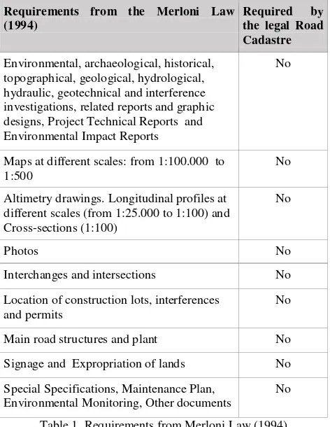
4.2.1 Requirements from literature review – Road Design: documents and data required for all construction projects (including both building and infrastructures) during three different stages (preliminary, final and executive). Finally, the Act of November 5, 2001 by the Italian Ministry of Infrastructures and Transport established “Functional and geometrical standards for road design”. The following data (derived from GIS and CAD) is requested (Table 1):
Requirements from the Merloni Law designs, Project Technical Reports and Environmental Impact Reports
No
Maps at different scales: from 1:100.000 to 1:500
No
Altimetry drawings. Longitudinal profiles at different scales (from 1:25.000 to 1:100) and Cross-sections (1:100)
Main road structures and plant No
Signage and Expropriation of lands No
Special Specifications, Maintenance Plan, Environmental Monitoring, Other documents
No
Table 1. Requirements from Merloni Law (1994)
Similarly, Table 2 refers to road data requirements from the D.P.R. n. 554 of December 21, 1999:
Requirements from D.P.R. n. 554/1999 Required by the legal Road Cadastre
Administrative and Technical road category Yes
Speed limits, Design speed range and speed diagrams
No
Constructive elements of road (roadway, shoulder, pavement, etc. with size, position, spatial relationship)
Yes
Geometry of the road axes and Geometrical and traffic features of road sections
Partially
Road structures (bridges, tunnels, etc.) Partially
Barriers and lighting elements Yes
Signage No
Table 2. Requirements from D.P.R. n. 554/1999
4.2.2 Requirements from literature review – Road Maintenance: These include “Road Asset Management - An ERF position paper for maintaining and improving a sustainable and efficient road network” from the European Union Road Federation (ERF) (2014), providing guidelines to create a data structure for road maintenance and to implement a road inventory to be updated regularly. The “Transport Notes of the World Bank” (Burningham and Stankevich, 2005) also require financial information (Table 3).
All the constructive elements of roads (e.g. Asphalt lanes,Walking path, Parking area)
Partially
Equipment (e.g. Signs, Street lighting, Barriers)
Partially
Structures (e.g. Bridges, Tunnels) Partially
Historical data on construction and Use of roads
Partially
Elements related to the management of public transport services, energy, water and
telecommunication (only urban roads)
No
Requirements from the Transport Notes of the World Bank (2005)
Required by the legal Road Cadastre
Surface (paved, unpaved) No
Type of maintenance (routine, periodic, urgent), Work type and Description
No
Financial Unit Cost No
Table 3. Requirements from the guidelines on road asset management by ERF (2014) and Transport Notes of the World Bank (Burningham and Stankevich, 2005)
4.2.3 Users' requirements from surveys and interviews (compared with the existing cadastral law and literature): The literature review above has been compared with the results from the questionnaires issued to road designers and the interviews of road designers, maintainers and managers as described in Section 3. Table 4 summarises the comparison
Detailed defect monitoring ✓
Materials ✓
Table 4. Requirements for documenting roads (design, upgrade and maintenance stages)
(with survey geometry and details) and construction elements of roads (with size, position, and spatial relationship) are the only data from the legal Road Cadastre also mentioned by literature and all stakeholders. However, both designers and maintenance engineers would also add non-cadastral maps, photos, ortho-photos and new survey techniques (e.g. laser scans). Geometry (included in the legal Road Cadastre) is also requested as well as information on structures under the road surface (e.g. underpasses, manholes) and a 3D model of terrain and road. Road equipment (e.g. signage and lighting elements) and road traffic and accident data are required for maintenance and upgrade, with information on maintenance works, road surface quality, and “as built” drawings also listed.
Requirements from designers/planners only: as the interviews highlighted, road designers primarily need additional (non-Cadastral) data to support preliminary multifactorial analyses and feasibility studies: that includes the survey of the terrain to produce a 3D road model, environmental data for monitoring the movement of the ground around roads, legal documents and urban plans to know constraints and land uses, data on the existing trunk roads (e.g. maintenance, geometric information to study issues of visibility and line-of-sight), and also speed limits and road safety analysis to ensure road designs conform to safety standards. Additional requirements include: plano-altimetric information to support design, as well as barriers, data on plant (e.g. electrical system, waterworks) and underground utilities to check any clashes. Road designers involved in road maintenance would include date of construction and of maintenance interventions to the basic Road Cadastre, as well as a register of the principal ditches, manholes, construction of embankments and riverbank protections, and a comprehensive map of infrastructure (underground utilities included).
Requirements from maintenance engineers only: ANAS road managers, dealing with road management and maintenance in particular, are mainly interested in administrative data and road maintenance data (e.g. road surface quality). To support this the ANAS Road Cadastre includes not only all data by the Act of June 1, 2001, but also advertising signs for road management and maintenance and monitoring data of defects in roads and structures to help prioritise interventions.
4.2.4 Requirements for 3D data:
From questionnaires: Figure 4 shows the ranked elements of road structure that road designers would like in 3D.
Figure 4: Road Designers’ Priorities for 3D Road Description
From interviews: Road designers require a 3D model of the road platform, describing roadways, roadsides, escarpments, barriers, and structures, and including surveys structural data, the size of each element, details such as joints and supports for maintenance purposes as well as data on any significant deterioration and instability of viaducts. According to road
managers, a three-dimensional geometric survey of the road (including the paved upper surface, embankments and trenches escarpments) would also complete the aero-photogrammetric survey, especially in the case of bridges, viaducts and tunnels where shape and internal details - utilities systems and signage included - are not visible. All the stakeholders would use 3D data to document drainage, wires, power lines, gas, optic fibres and any other network of services to prevent service interruption.
4.3 A 3D conceptual model and approach for the Road Cadastre
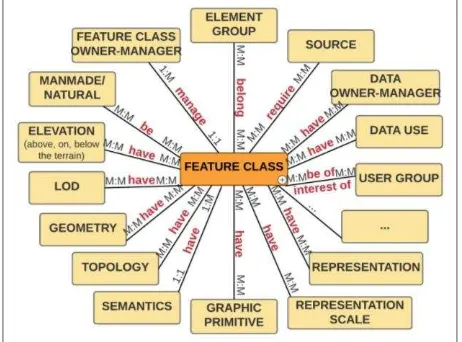
A conceptual model is an abstraction or simplification of reality to help better understand real world systems, facilitate communication and integrate knowledge across disciplines (Heemskerk et al., 2003). As noted above, literature and stakeholders often require the same elements relating to roads but just taking a different focus for what is the most important in the group. Therefore, a new table was generated to look at each element individually and to group them by various factors including: the element or feature class (e.g. road element, curb, barrier), the macroclass that it belongs to (e.g. road, equipment, structure), whether it is 'man-made' or 'natural', whether it is on the ground, above or below (elevation), the source (e.g. which standard, interview, survey requires it), the level of detail (LoD) with relating geometry, topology, semantics and graphic primitive, the required representation (e.g. vector such as GIS and CAD, raster like ortophotos and maps, or 3D model and PDF) and relating scale, the user group that would use the element (e.g. road designers, road maintainers, road managers, safety designers, drivers), the data use (e.g. study of feasibility, road/environmental/tourism&route planning and monitoring, emergency management and response, road maintenance, safety
management, evaluation of interferences, sight distance, GPS and in-car navigation, street directories, facilities), and so forth.
Figure 5: Meta-model for a 3D road cadastre
Figure 5 represents the proposed conceptual data model deriving from the table: a meta-diagram starting from the current Road Cadastre structure compared with the technical and social requirements collected and focused on 3D. The majority of the
relationships are many:many – e.g. one source is associated with
many elements, and an element can be required by more than one source. This approach aims at reflecting the flexibility and
multi-use of the model that can also be thought as “a cluster of
clusters”. From it a number of physical models reflecting the potential users may be generated, showing how useful each
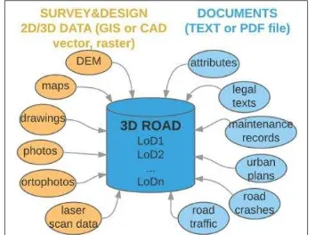
Figure 6 – High Level Overview of the 3D Road Cadastre
The 3D model proposed includes a wide range of different data (Fig.6). Within the model spatial entities (i.e. environment, road infrastructures and the elements they are made of) are modelled in 3D and queryable providing data as text, images and maps as PDF and JPG files, which can be linked to a road, a section of road or a specific element in the model. This mixed data types approach is fundamental as the questionnaires and interviews, as well as emerging Smart Cities and ITS requirements, highlight the importance of a flexible approach to modelling. Thus, not only does 3D enable realistic modelling of real world objects, the 3D environment also facilitates access to other data, serving as a data indexing mechanism.
4.4 3D GIS utilities in implementing Road Cadastre – Questionnaires and Interview Results
As noted above (Section 2.3.2), a number of authors have investigated the potential of 3D GIS in a Road Cadastre situation. Both the results from the questionnaires and the interviews confirmed the validity of the approach, with all respondents to both noting that having access to a 3D model, integrated with the road inventory/cadastral data, would be useful. Respondents to the questionnaires cited uses including: a) feasibility studies - to assess in the preliminary planning stage the possible effects and consequences of interference (interviews and questionnaires); b) to have a complete set of information to support road maintenance or subsequent road designs (questionnaires) or maintenance tasks (interviews); c)
to carry out possible designs additional to the core project – e.g.
relating to neighbouring areas – more rapidly, especially in case
of emergency interventions (e.g. to know the sequence of ditches, manholes, etc.) (questionnaires); d) to carry out preliminary tests on the road (safety, visibility) (questionnaires and interviews) and carry out a performance evaluation of the road structure (interviews); e) to have a visual and practical record of the project (questionnaires); f) to identify and resolve problems of clashes between plant, road elements, underground utilities and structures (questionnaires); g) to access to elevation/altimetry data, and provide an immediate view of the morphology of the land, the geometry of existing works and how this may be altered (interviews); h) to understand the composition of the road bed (interviews).
Eight out of nine questionnaire respondents would also like to see the integration between 3D and 4D representations of roads within a road inventory resulting in a single model able to describe the infrastructure’s life cycle and to confirm and support the planning of road maintenance programs. Interview respondents also noted that maintenance activities would benefit from 3D GIS for documenting and analysing minor works (e.g. walls) and road surfaces (that ANAS currently records after maintenance interventions on paper).
5* DISCUSSION
The literature review, questionnaires and interviews seem to confirm that the use of 3D GIS would improve road cadastre for better management of data related to the complete life-cycle of infrastructure projects. The model and approach proposed to be all encompassing – i.e. to model every single possible element and feature of a road network. Indeed, this may not be possible and would not take into account emerging future requirements such as ITS and Smart Cities. Instead, through its many different elements, the model aims at being consistent with the multi-purpose nature of a road inventory discussed in Section 2.1, taking into account the “multidimensional” – from 1D (linear reference) to 4D (including 3D space and time) - and “multifaced” (Ndandiko et al. 2013) nature of a road. The proposed model extends the existing road cadastre concept, which deals only with ownership and maintenance, to include 3D modelling and to cover the entire life-cycle of a road network, from conception onwards. Importantly, the model is extensible and flexible, allowing for different levels of detail in the geometry and links to the attributes and other information (documents, survey results, photographs, video and so forth) – thus this supports a wide variety of existing data. The 3D-based approach also provides the potential for the 3D model to act as an index and integrator for other data – where associating data with a location in 3D space allows it to be linked to other data where this would otherwise not be possible. The ability to visualise and explore data in 3D also adds not inconsiderable value. The approach also takes into account the need to provide information in different formats to different users from one central source, allowing multiple representations if necessary – e.g. a laser-scanned survey of the terrain may be useful to a road designer planning a new road, as well as a 3D vector model of the same location to a road safety expert or the person installing signage. In this, the approach described here mirrors that of emerging BIM processes (where there is a concept of a ‘single source of truth’ datastore). As with BIM, this centralised source of information can assist in communication between various design teams (traffic safety, construction teams, drainage engineers, utilities engineers) and also helps to minimise re-capture of data – the ‘as-built’ information resulting from the road construction phase can be directly used by any maintenance engineers. Both the questionnaires and interviews revealed that there is some familiarity with GIS in the community, but both designers and maintenance engineers would prefer to work with tools with which they are familiar: a database-centric approach could permit this. In many cases, simply having access to an interactive 3D visualisation of the data, with links to further information, may be sufficient.
6* CONCLUSIONS AND FURTHER WORK
As noted above, there is a good correspondence between the 3D-related requirements highlighted in literature (Section 2.3.2) and in the questionnaires and interviews (Section 4.2.3), further supporting the potential 3D in the context of a road cadastral system, but not reflected in the current road cadastral standards. Future work will include understanding how to represent each road part (e.g. as a geometry or just as a PDF or point cloud) and which data capture to prioritise to meet most requirements, then developing physical models for 3D road cadastres related to the technical and social requirements emerged.
REFERENCES
Bokyo, A. and Funkhouser, T., 2012. Extracting roads from dense point clouds in large scale urban environment. ISPRS P&RS, 66(6), pp. S2-S12.
Burchi, A., Cina, A., Rosso, D., Piras, M., 2009. Il Catasto Strade della Regione Piemonte. Le Strade n. 5, pp. 132-139.
Burningham, S., and Stankevich, N., 2005. Why Road Maintenance is Important and How to Get it Done. Transportation Note No. TRN-4. World Bank, Washington, DC.
Cai, H., Oh, J., and Yang, D., 2012. Integrating GIS and Microscopic Traffic Simulation to Analyze Impacts of Transportation Infrastructure Construction. J. Comput. Civ. Eng., 26(4), pp. 478-487.
Caroti G., Piemonte A., 2010. Standard per la generazione del grafo stradale a cui appoggiare rilievi di catasto strade: il caso della Toscana e del Comune di Pisa. Bollettino della Società Italiana di Fotogrammetria e Topografia n.3, pp. 69-80.
Cheng, T., Xu, L., Su, G., Yuan, H., 2014. GIS Based Spatial Collaboration in Urban Critical Infrastructure Emergency Response. In: 2014 International Conference on Information GIS and Resource Management, Lancaster, Pennsylvania, U.S.A., pp. 85-91.
Di Mascio, P., Cera, L., Palermo, C., 2004. Road Sign Management System of Teramo Province, Italy. In: Proceedings of the 2nd European Pavement and Asset. Management Conference, Berlin, 21-23 marzo 2004, pp. 1-12. ERF, 2014. Road Asset Management. An ERF Position Paper for Maintaining and Improving a Sustainable and Efficient Road Network.
Fredericque, B., Lapierre, A., Byrn, P., 2009. 3D City GIS for sustaining city infrastructure: the Bentley approach, In: ISPRS Archives, Lund, Sweden, Vol. XXXVIII-2/W11.
Hatger, C., Brenner, C., 2003. Extraction of road geometry parameters from laser scanning and existing databases. In: ISPRS Archives, Dresden, Germany, Vol. XXXIV-3/W13, pp. 225–230.
Haubrich, T., Seele. S., Herpers, R., Muller, E.M., Becker, P., 2013. Semantic Road Network Models for Rapid 3D Traffic Scenario Generation. In: Tagungsband ASIM/GI-Fachgruppentreffen STS/GMMS, Workshop Simulation technischer Systeme - Grundlagen und Methoden in Modellbildung und Simulation, pp. 51–55.
Heemskerk, M., Wilson, K., Pavao-Zuckerman, M., 2003. Conceptual models as tools for communication across disciplines. Conservation Ecology, 7(3), p. 8.
Higuera de Frutos, S. and Castro, M., 2014. Using smartphones as a very low-cost tool for road inventories. Transportation Research Part C: Emerging Technologies, 38, pp. 136-145.
Kiema, J.B.K., and Mwangi, J.M., 2009. A Prototype GIS-Based Road Pavement Information and Management System. J Civil Eng Res Pract, 6(1).
King, H, Kratzchmar, M., 2010. TransInfo Project Replacing a Legacy System: Institutional Adventures in COTS Software Acquisition and Implementation. Presentation at 2010 GIS for Transportation Conference Charleston, West Virginia. http://www.gis-t.org/files/QJXUe.pdf (11 Dec 2015).
Lefler, N., Fiedler, R., Abbott, D.E., 2013. Presentation at 92nd Annual Meeting of the Transportation Research Board, Washington D.C. “Using GIS to develop an intersection inventory for safety”. http://docs.trb.org/prp/13-4663.pdf (11 Dec 2015).
Luliang, T. and Qingquan, L., 2004. The Research of Transect-Based Three-Dimensional Road Model. ISPRS Archives, Istanbul, Turkey, Vol. XXXV, Part B5, pp. 174-177.
Mammarella, J.J., 2014. Road Inventory. In: Encyclopedia of Transportation: Social Science and Policy, SAGE Publication, Los Angeles, California, pp. 1165-1169.
Manyazewal, A., La, Anil M., Prasad, CSRK, 2014. No.201/ISRS Proceedings 2014/ISPRSTCVIII Mid-Symposium, Hyderabad, India “Advanced Information System for Planning and Maintenance of Rural Road using GIS”.
http://www.isrsindia.in/isprs_doc/isrs_p_201.pdf (1 May 2016).
Mohaymany, A. S., Shahri, M., Mirbagheri, B., 2013. GIS-based method for detecting high-crash-risk road segments using network kernel density estimation. Geo-spatial Information Science, 16(2), pp. 113-119.
Oregon Department of Transportation, 2012. Analysys
Procedure Manual Version 2.
http://www.oregon.gov/ODOT/TD/TP/APM/APMv2_%20Ch1. pdf (11 Dec 2015).
Parami Dewi, A.A.D., 2013. Framework for implementing design build project delivery system in road infrastructure projects in Indonesia, Queensland University of Technology, Australia. http://eprints.qut.edu.au/61741/ (13 May 2016).
Road Transport Forecasts 2013. Results from the Department for Transport's National Transport Model, 2013.
https://www.gov.uk/government/uploads/system/uploads/attach ment_data/file/260700/road-transport-forecasts-2013-extended-version.pdf (1 May 2016).
Sandgren, U., 2004. EUROROADS – PAN-EUROPEAN ROAD DATA SOLUTION. Proceedings of the 10th ECGI & GIS Workshop, ESDI State of the Art, Warsaw, Poland, 23-25 June 2004. http://www.ec-gis.org/Workshops/10ec-gis/papers/23june_sandgren.pdf (13 May 2016).
Schultz, G. G., Johnson, E. S., Black, C. W., Francom, D., Saito, M., 2012. Report No. UT-12.06 “Traffic & Safety Statewide Model and GIS Modeling”, Utah Department of Transportation
Research Division, Salt Lake City.
http://ntl.bts.gov/lib/45000/45600/45614/UT-12.06_FINAL_REPORT.pdf (16 May 2016).
Seguì Pons, J. and Ruiz Perez, M., 2003. Geographic information systems and intelligent transport systems: technologies used to form new communication networks. Networks and Communication Studies, 17(1-2), pp. 53-70.
Sharp, H., Rogers, Y., Preece, J., 2011. Interaction Design - Beyond Human Computer Interaction, John Wiley & Sons Ltd, New York.
SITECO INFORMATICA SRL, 2008. Catasto Strade: panoramica, tendenze e innovazioni. MondoGIS, nov-dic 69/2008, pp. 52-56.
Steere, A., 2012. Automated GIS routing network for oversize/overweight vehicles. Proquest Umi Dissertation
Sun, M. and Chen, J., 2000. Data structure research of 3D city road network. In: ISPRS Archives, Amsterdam, Netherland, Vol. XXXIII, Part B4, pp. 1025-1032.
Vella, M., 2008. Conference paper at XVIII Convegno Tecnico ACI, Roma, June 26-27 2008 “Il Catasto stradale e i dati di traffico: limiti attuali e proposte di adeguamento”.
http://www.aci.it/fileadmin/documenti/studi_e_ricerche/monog rafie_ricerche/XVIII_Convegno_Tecnico/VELLA.pdf (1 May 2016).
Wathen, J., 1991. Developing A Road Inventory. Maine
Townsman. Legal Note, April 1991.
http://www.maine.gov/mdot/csd/mlrc/documents/pdf/Developi ngARoadInventory.pdf (1 May 2016).
Wix, J. and Nisbet N., 2008. Internal DTI report “Study into the Business Case for Interoperable Building Information Modelling (BIM)”, https://www.gov.uk/government/uploads/system/
uploads/attachment_data/file/34710/12-1327-building-information-modelling.pdf (23 May 2016).
World Highways. International Road Federation, 1990. Vol. XLI, No. 8, Wahington D.C.
Xiao, F., Hongyu, Z., Caixia, Y., 2012. Development of Road Maintenance Management System Based on WebGIS. IJCEE, 6(5), pp. 294-298.
Yuan, L., 2008. 3D Hierarchical Road Network. GIM