OGC® Engineering Report OGC 14-006r1
Copyright © 2014 Open Geospatial Consortium. 1
Open Geospatial Consortium
Publication Date: 2014-07-15
Approval Date: 2014-05-14
Posted Date: 2014-05-21
Reference number of this document: OGC 14-006r1
Reference URL for this document: http://www.opengeospatial.net/doc/PER/testbed10/exchange-terrain-data
Category: Public Engineering Report
Editor:Daniel Balog
OGC
®Testbed 10 Recommendations for Exchange of
Terrain Data
Copyright © 2014 Open Geospatial Consortium.
To obtain additional rights of use, visit http://www.opengeospatial.org/legal/.
Warning
This document is not an OGC Standard. This document is an OGC Public
Engineering Report created as a deliverable in an OGC Interoperability Initiative and is not an official position of the OGC membership. It is distributed for review and comment. It is subject to change without notice and may not be referred to as an OGC Standard. Further, any OGC Engineering Report should not be referenced as
required or mandatory technology in procurements.
Document type: OGC® Engineering Report
Document subtype: NA
Document stage: Approved for public release
Preface
This document is a deliverable of the OGC Testbed 10 (Testbed-10). Its contents cover the summary of the work carried out regarding the recommendations for the exchange of terrain data.
Suggested additions, changes, and comments on this draft report are welcome and encouraged. Such suggestions may be submitted by email message or by making suggested changes in an edited copy of this document.
License Agreement
Permission is hereby granted by the Open Geospatial Consortium, ("Licensor"), free of charge and subject to the terms set forth below, to any person obtaining a copy of this Intellectual Property and any associated documentation, to deal in the Intellectual Property without restriction (except as set forth below), including without limitation the rights to implement, use, copy, modify, merge, publish, distribute, and/or sublicense copies of the Intellectual Property, and to permit persons to whom the Intellectual Property is furnished to do so, provided that all copyright notices on the intellectual property are retained intact and that each person to whom the Intellectual Property is furnished agrees to the terms of this Agreement.
If you modify the Intellectual Property, all copies of the modified Intellectual Property must include, in addition to the above copyright notice, a notice that the Intellectual Property includes modifications that have not been approved or adopted by LICENSOR.
THIS LICENSE IS A COPYRIGHT LICENSE ONLY, AND DOES NOT CONVEY ANY RIGHTS UNDER ANY PATENTS THAT MAY BE IN FORCE ANYWHERE IN THE WORLD.
THE INTELLECTUAL PROPERTY IS PROVIDED "AS IS", WITHOUT WARRANTY OF ANY KIND, EXPRESS OR IMPLIED, INCLUDING BUT NOT LIMITED TO THE WARRANTIES OF MERCHANTABILITY, FITNESS FOR A PARTICULAR PURPOSE, AND NONINFRINGEMENT OF THIRD PARTY RIGHTS. THE COPYRIGHT HOLDER OR HOLDERS INCLUDED IN THIS NOTICE DO NOT WARRANT THAT THE FUNCTIONS CONTAINED IN THE INTELLECTUAL PROPERTY WILL MEET YOUR REQUIREMENTS OR THAT THE OPERATION OF THE INTELLECTUAL PROPERTY WILL BE UNINTERRUPTED OR ERROR FREE. ANY USE OF THE INTELLECTUAL PROPERTY SHALL BE MADE ENTIRELY AT THE USER’S OWN RISK. IN NO EVENT SHALL THE COPYRIGHT HOLDER OR ANY CONTRIBUTOR OF INTELLECTUAL PROPERTY RIGHTS TO THE INTELLECTUAL PROPERTY BE LIABLE FOR ANY CLAIM, OR ANY DIRECT, SPECIAL, INDIRECT OR CONSEQUENTIAL DAMAGES, OR ANY DAMAGES WHATSOEVER RESULTING FROM ANY ALLEGED INFRINGEMENT OR ANY LOSS OF USE, DATA OR PROFITS, WHETHER IN AN ACTION OF CONTRACT, NEGLIGENCE OR UNDER ANY OTHER LEGAL THEORY, ARISING OUT OF OR IN CONNECTION WITH THE IMPLEMENTATION, USE, COMMERCIALIZATION OR PERFORMANCE OF THIS INTELLECTUAL PROPERTY.
This license is effective until terminated. You may terminate it at any time by destroying the Intellectual Property together with all copies in any form. The license will also terminate if you fail to comply with any term or condition of this Agreement. Except as provided in the following sentence, no such termination of this license shall require the termination of any third party end-user sublicense to the Intellectual Property which is in force as of the date of notice of such termination. In addition, should the Intellectual Property, or the operation of the Intellectual Property, infringe, or in LICENSOR’s sole opinion be likely to infringe, any patent, copyright, trademark or other right of a third party, you agree that LICENSOR, in its sole discretion, may terminate this license without any compensation or liability to you, your licensees or any other party. You agree upon termination of any kind to destroy or cause to be destroyed the Intellectual Property together with all copies in any form, whether held by you or by any third party.
Except as contained in this notice, the name of LICENSOR or of any other holder of a copyright in all or part of the Intellectual Property shall not be used in advertising or otherwise to promote the sale, use or other dealings in this Intellectual Property without prior written authorization of LICENSOR or such copyright holder. LICENSOR is and shall at all times be the sole entity that may authorize you or any third party to use certification marks, trademarks or other special designations to indicate compliance with any LICENSOR standards or specifications.
This Agreement is governed by the laws of the Commonwealth of Massachusetts. The application to this Agreement of the United Nations Convention on Contracts for the International Sale of Goods is hereby expressly excluded. In the event any provision of this Agreement shall be deemed unenforceable, void or invalid, such provision shall be modified so as to make it valid and enforceable, and as so modified the entire Agreement shall remain in full force and effect. No decision, action or inaction by LICENSOR shall be construed to be a waiver of any rights or remedies available to it.
Contents
PageExecutive Summary ... 7
1 Introduction ... 10
1.1 Scope ... 10
1.2 Document contributor contact points ... 10
1.3 Future work ... 10
1.4 Forward ... 11
2 References ... 11
3 Abbreviated terms ... 11
4 Overview of Terrain Data Exchange Requirements for Aviation ... 12
5 Examined Terrain Data formats ... 15
5.1 TIXM ... 15
5.1.1 Introduction ... 15
5.1.2 Data ... 16
5.1.2.1 External Reference ... 16
5.1.2.2 Inline Data ... 16
5.1.3 Metadata ... 17
5.2 GeoPackage ... 17
5.2.1 Introduction ... 17
GeoPackage is an SQLite-based database file that is currently being developed by the OGC® GeoPackage SWG. It was originally intended as a mobile raster and vector exchange format, but it can have its uses on desktop clients and servers as well. ... 17
5.2.2 Data ... 17
5.2.3 Metadata ... 18
5.3 Elevation Surface Model ... 19
5.3.1 Introduction ... 19
5.3.2 Data ... 19
5.3.2.1 Grid Coverage ... 20
5.3.2.2 TIN Coverage ... 20
5.3.2.3 Point Coverage ... 20
5.3.2.4 Point Cloud ... 21
5.3.3 Metadata ... 21
5.4 Comparison ... 21
5.4.1 Compliance with ICAO Annex 15 and ADQ ... 21
5.4.2 Support for metadata (ISO 19115) ... 22
5.4.3 Support for usage in OGC services ... 22
5.4.4 Completeness ... 23
5.4.5 Scalability ... 23
5.4.6 Industry adoption potential ... 24
5.4.7 Conclusion ... 25
5.4.7.1 Recommendations ... 25
5.4.7.2 TIXM ... 25
5.4.7.3 GeoPackage ... 26
5.4.7.4 ESM ... 26
6 Analysis of Cross-Border Differences in Terrain Data ... 26
6.2 Approaches ... 26
6.3 Centralized ... 27
6.4 Per state ... 27
6.5 Per client ... 27
7 Analysis of Web-Based access to eTOD data in an INSPIRE compliant way ... 28
7.1 Introduction ... 28
7.2 Relevance for the terrain data representation and access ... 28
7.3 Representing elevation data ... 28
7.3.1 Spatial representation ... 28
7.3.2 Coordinate reference system ... 29
7.3.3 Vertical datum ... 29
7.3.4 Data encoding ... 29
Use GML or TIFF as encoding for gridded land-based elevation data; use GML or a BAG file for bathymetric elevation data. TIN data shall be encoded using GML TIN. Additionally, only compression methods are valid that do not lead to data loss. From the investigated candidate terrain formats, both TIXM, GeoPackage and ESM offer compatibility with this requirement: ... 29
TIXM directly relies on GML to describe elevation data; additionally, it can also link to an external file in the TIFF format for the actual data. ... 29
GeoPackage and ESM are not specifically tied to a data encoding. In GeoPackage, extensions can be easily defined that use TIXM, TIFF, or any encoding format of choice. ... 29
7.4 Providing web-based access to elevation data ... 29
7.4.1 Access via a download service ... 29
7.4.2 Access via a view service ... 30
7.4.3 Discovery service ... 31
A key concept in the INSPIRE network services is the discovery service, enabling users to discover, browse and query data made available by the previously discussed services. Applied to the the use case of accessing terrain data, a discovery service could be used to discover which terrain data sets are made available and their quality characteristics. ... 31
A practical implementation of a discovery service can be found in the OGC Catalogue Service 2.0. ... 31
7.4.4 Updates ... 31
8 Conclusion & recommendations ... 31
8.1 Terrain data formats ... 31
8.2 Cross-border differences in terrain data ... 32
8.3 INSPIRE-compliant, web-based access to terrain data ... 32
Annex A TIXM XML Schema Documents ... 34
Annex B ... 40
Annex C ... 43
Revision history ... 48
Figures and tables
Figure 1 - Example of coverage areas 14
Figure 2 - Recommended resolution and accuracy values per coverage level (ICAO
Annex 15) 14
Figure 3 - Basic metadata available for a pyramid structure 19
Figure 4 - Basic metadata available for a zoom level 19
Figure 5 - Example of a grid coverage 20
Figure 6 - Example of a TIN coverage 20
OGC
®Testbed 10 Recommendations for Exchange of
Terrain Data
Executive Summary
IntroductionThis document provides recommendations for the exchange of terrain data for aviation purposes. A main focus point is the identification of terrain formats that comply with ICAO Annex 15 and ADQ requirements for the representation of terrain data. All ICAO member states need to provide chart, terrain and obstacle data in an electronic form, fully relying on the ISO 19100 series of geographic information standards. One important challenge for the terrain data provision is to overcome cross-border differences due to differences in national geodetic systems, a topic which is also investigated. Finally, guidance is offered to provide web-based access to terrain data, in an INSPIRE-compliant way.
Background information
Since the birth of civil aviation in the first part of the 20th century, the International Civil Aviation Organization (ICAO) has been defining standards and recommended practices concerning civil aviation. One important aspect is the gathering,
management and publication of aeronautical information, governed by the ICAO Annex 15 standard. Its 12th and most recent edition defines that all members need to provide chart, terrain and obstacle data in an electronic form, relying on the ISO 19100 series of geographic information standards.
To achieve interoperability of the European Air Traffic Management Network (EATMN) upon adopting ICAO Annex 15 edition 12, the European Commission (EC) mandated Eurocontrol in 2005 to assist the EC in the development of an
interoperability implementing rule on Aeronautical Data and Information Quality. The purpose was to supplement and strengthen the requirements of ICAO Annex 15 in order to achieve aeronautical information of sufficient quality. This mandate resulted in the ADQ draft implementing rule, adopted by the EC in 2010, hereafter simply referred to by ADQ.
To comply with the requirements for electronic chart and obstacle data, the AIXM 5.1 format can be used today. For terrain data, there is no recommended format yet identified. This engineering report takes the requirements set forth by ICAO Annex 15 and the derived ADQ as a basis to identify and evaluate a number of terrain formats. Specific attention is paid on the topic of cross-border elevation differences, which should be resolved to provide seamless terrain data to the user.
Apart from aviation, the EC also launched an initiative to integrate and harmonize the representation and delivery of geographical information provided by its member states, called Infrastructure for Spatial Information in the European Community or INSPIRE. When implemented, it will facilitate the discovering, accessing and sharing of public sector data in a much more standardized way allowing the sharing of
This engineer report investigates the possibilities for web-based access to terrain data in an INSPIRE compliant way.
Recommendations / main conclusions
This document analyzes and compares three potential formats for the exchange of terrain data:
TIXM
OGC GeoPackage
Elevation Surface Model (ESM)
All three formats have their advantages and disadvantages. Important for this document is to verify their compliancy with ICAO Annex 15 and ADQ, as well as some practical considerations when implementing them in industry-specific applications.
In terms of metadata support, all three formats are compliant with ICAO Annex 15 and ADQ. The TIXM format is being developed with a dedicated ISO 19115/19139 metadata profile for terrain data. At the time of writing, this profile is not yet fully up to date, but it is assumed that this will be completed some time in the future.
In terms of data representation, the three formats differ in their abilities. ESM is by far the most extensive format, with many options to represent elevation data. TIXM can act as a metadata wrapper for existing formats, or contain GML-based elevation data. OGC GeoPackage is the most mature format of the three, with high industry support behind it. While there are several advantages to using OGC GeoPackage as primary terrain exchange format (such as efficiency, ease-of-use, multi-leveling), it would require a few extensions to support elevation data, using the GeoPackage extension mechanism.
In terms of distribution, an OGC WCS service is considered the most suitable for all three formats. A WCS service has specific parameters that apply to exchanging grid coverages (e.g., resolution, interpolation, subset). All three formats can be served using an OGC WCS service. As an alternative, an OGC WMTS service can also be used to distribute multi-leveled, tiled data. This has its advantages as it allows for more fine-grained request for smaller sets of data. Note that OGC WMTS can also be used in combination with OGC WCS, where the WCS service acts as a data provider, and OGC WMTS service acts as a portrayal service.
From an industry adoption point of view, there are some other considerations to be made: Selective decoding, aggregate data and sparseness. Selective decoding allows efficient use of a subset of the data, aggregate data allows trading accuracy for performance when interactivity is desired and sparseness helps reducing bandwidth usage, application memory and processing requirements. The OGC GeoPackage format was built to consider all of these aspects, and as such, it is quite suitable for the purposes of terrain exchange. TIXM and ESM do however have the capability to reference an external file that also takes advantage of selective decoding, aggregate data and sparseness. (For instance: DTED, GeoTIFF, NITF…)
On the topic of providing seamless terrain data to the user, while avoiding potential cross-border elevation differences, three approaches have been investigated:
2. Consolidate a fixed terrain grid across multiple states
3. Shift responsibility to clients to merge different datasets
No clear recommendation can be made here; all approaches have advantages and disadvantages, which should be evaluated by all stakeholders to decide on a particular approach.
Finally, this document focusses on the requirements of the European INSPIRE initiative. INSPIRE recommends the following things:
1. A grid representation of the data should be offered
2. Use of a common grid based on ETRS89 coordinates
3. Use of EVRS vertical datum to express gravity-related heights
4. The use of GML or TIFF is recommended for grid-based elevation data.
5. Use of OGC WCS 2.0 web service to exchange terrain data.
6. Use of OGC WMS 1.3.0 or WMTS 1.0 for portrayal, together with OGC Symbology Encoding for the styling of data.
Apart from point 4, all investigated formats conform to the recommendations given by INSPIRE. To comply with point 4 (The use of GML or TIFF data), it is
OGC
®Testbed 10 Recommendations for Exchange of
Terrain Data
1 Introduction
1.1 Scope
This OGC® document describes the recommendations for the exchange of Terrain Data for the Aviation Thread of Testbed 10. The specific requirements of Testbed-10 Aviation Terrain Data Exchange are focused around the analysis of existing and new terrain data formats, and their compliance to existing standards and requirements. This document includes:
Identification of possible formats of the exchange of terrain dataset compliant with ICAO Annex 15 and ADQ requirements.
Identification of possible ways to overcome cross-border differences in terrain data due to differences in national geodetic systems and provision of seamless terrain data.
Identification of possibilities of web-based access to eTOD data in an INSPIRE compliant way.
While the subject of electronic Terrain and Obstacle data (eTOD) is touched, it is outside of the scope of this report to analyze Obstacle data. This report focuses on Terrain data.
1.2 Document contributor contact points
All questions regarding this document should be directed to the editor or the contributors:
Name Organization
Daniel Balog Luciad NV
Thomas De Bodt Luciad NV
Robin Houtmeyers Luciad NV
1.3 Future work
Improvements in this document are desirable to the following topics.
Investigation of the suitability of aggregate data and possible requirements in this area. For instance, an aggregate function is typically the average, but others might be needed (e.g., maximum).
1.4 Forward
Attention is drawn to the possibility that some of the elements of this document may be the subject of patent rights. The Open Geospatial Consortium shall not be held responsible for identifying any or all such patent rights.
Recipients of this document are requested to submit, with their comments, notification of any relevant patent claims or other intellectual property rights of which they may be aware that might be infringed by any implementation of the standard set forth in this document, and to provide supporting documentation.
2 References
The following documents are referenced in this document. For dated references, subsequent amendments to, or revisions of, any of these publications do not apply. For undated references, the latest edition of the normative document referred to applies.
OGC 06-121r3, OGC® Web Services Common Standard
NOTE This OWS Common Standard contains a list of normative references that are also applicable to this Implementation Standard.
OGC 12-128r10, OGC® GeoPackage Encoding Standard
OGC 09-146r2, OGC® GML Application Schema for Coverages
OGC 09-110r4, OGC® WCS 2.0 Interface Standard-Core: Corrigendum
ISO 19115:2003 & 19115-1:2014, Geographic information- Metadata
ISO 19123:2005, Geographic information- Schema for coverage geometry and function
In addition to this document, this report includes several XML Schema Document files as specified in Annex A.
3 Abbreviated terms
ADQ Aeronautical Data Quality
AIXM Aeronautical Information Exchange Model
BLOB Binary large object
DGIWG Defense Geospatial Information Working Group
DMF DGIWG Metadata Foundation
DTED Digital Terrain Elevation Data
ER Engineering Report
ESM Elevation Surface Model
eTOD electronic Terrain and Obstacle Data
ETRS European Terrestrial Reference System
EVRS European Vertical Reference System
GML Geography Markup Language
ICAO International Civil Aviation Organization
INSPIRE Infrastructure for Spatial Information in the European Community
ISO International Organization for Standardization
JPEG Joint Photographic Experts Group
LOD Level of Detail
MIME Multipurpose Internet Mail Extensions
OGC Open Geospatial Consortium
PNG Portable Network Graphics
RDBMS Relational database management system
SWG Standards Working Group
TICM Terrain Data Conceptual Model
TIFF Tagged Image File Format
TIN Triangulated Irregular Network
TIXM Terrain Data Exchange Model
WCS Web Coverage Service
WMS Web Map Service
WMTS Web Map Tiling Service
XML Extensible Mark-up Language
4 Overview of Terrain Data Exchange Requirements for Aviation
The ADQ Draft Implementing Rule, described in Commission Regulation (EU) No 73/2010 [1], states the importance of electronic Terrain Data:
A significant amount of paper-based, manual activity still takes place within the aeronautical data chain, which leads to significant opportunities for the
introduction of errors and the degradation of data quality. …In accordance with the requirements of Regulation (EC) No 552/2004, aeronautical information should be provided progressively in an electronic form, based on a commonly agreed and standardised data set.
While classical Terrain Data formats (such as DTED) can be used in existing OGC® Services (such as OGC® WCS), it is found that they are often limiting in their capabilities, especially when it comes to representing metadata. The requirement for metadata is becoming increasingly important, and we will stress this point throughout the report.
In this Engineering Report we focus on identifying and analyzing possible Data Formats for the exchange of Terrain Data. For each of the identified Data Formats, we analyze them in the context of a set of requirements and considerations:
Compliance with ICAO Annex 15 [2]
Compliance with ADQ
Support for metadata (ISO 19115)
Support for usage in OGC Services
Industry adoption potential
Completeness
Scalability
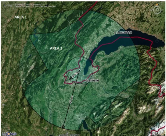
Data coverage requirement: sets of electronic terrain and obstacle data shall be collected and recorded in databases in accordance with the following coverage areas:
Area 1: entire territory of a state
Area 2: terminal control area
Area 3: aerodrome / heliport area
Area 4: Category II or III operations
Figure 1 - Example of coverage areas
The recommended resolution and accuracy values per coverage level can be seen in figure 2.
Figure 2 - Recommended resolution and accuracy values per coverage level (ICAO Annex 15)
To model these figures and present them correctly and with confidence to a client, we also need a way of defining metadata for Terrain Data. According to the ICAO Annex 15 and its derived ADQ requirements, the metadata for Terrain Data should include (at the very least) the following items:
1. The data originator of the data
2. Amendments made to the data
4. Details of any validation and verification of the data that has been performed
5. Effective start date and time of the data
6. For geospatial data:
a. The earth reference model used
b. The coordinate system used
7. For numerical data
a. The statistical accuracy of the measurement
b. The resolution
c. The confidence level
8. Details of any functions applied if data has been subject to conversion/transformation
9. Details of any limitations on the use of data.
Apart from that, we also examine the problem of cross-border differences between Terrain Data, and generate a set of recommendations for how these problems can be addressed.
Finally, the possibilities for web-based access to eTOD (terrain) data in an INSPIRE-compliant way are being investigated.
5 Examined Terrain Data formats
For this study we have examined and compared 3 Terrain Data formats:
Terrain Data Exchange Model (TIXM)
OGC® GeoPackage
Elevation Surface Model (ESM)
5.1 TIXM 5.1.1 Introduction
The Terrain Data Exchange Model (TIXM) is an Extensible Mark-up Language (XML) Schema implementation of the Terrain Data Conceptual Model (TICM). Both TICM and TIXM are being developed by Eurocontrol with the purpose of having a Terrain specific data format that is compliant with requirements of ICAO Annex 15. The schema for TIXM can be found attached in Annex A.
5.1.2 Data
There are two core ways to use the TIXM schema:
As a metadata wrapper around existent Terrain Data
As a self-containing set of GML 3.2 points, next to its metadata
5.1.2.1 External Reference
In the first case, common Terrain Data files are linked through with the gml:fileName element. This element can be any URI. The MIME-type of the resulting binary data block can also be specified. Example of a link to an external DTED file:
<gml:rangeSet>
<gml:fileName>http://www.somedata.org/terrain.dt0</gml:fileName> <gml:fileStructure>Record Interleaved</gml:fileStructure>
<gml:mimeType>application/x-dted</gml:mimeType> </gml:rangeSet>
The external link has to be resolved separately from the TIXM file. This could be done asynchronously by software applications (i.e., in a background process) and only when needed in order to reduce bandwidth. The TIXM file contains metadata
regarding the geographical extent and data density, so this decision can be made without the external data.
Using a TIXM file to refer to external binary data files means that readily available Terrain Data formats can be re-used by clients that support them. It also means that on top of GML 3.2 and XML support, clients will have to implement support for a set of well-known raster formats.
5.1.2.2 Inline Data
TIXM also allows you to inline elevation data straight into the file, making it a stand-alone terrain format. For instance, elevation data can be encoded using a string of tuples:
<gml:rangeSet> <gml:DataBlock>
<gml:rangeParameters/>
<gml:tupleList>10.0 10.0 130.0, 10.0 11.0 135.0, 10.0 12.0 132.0</gml:tupleList>
</gml:DataBlock> </gml:rangeSet>
Alternatively, more descriptive geometry can also be used instead of a simple list of tuples. The TIXM schema defines tixm:ElevatedPoint geometry type. This type contains (apart from an elevation) some metadata to describe the elevated point itself:
<complexType name="ElevatedPointType"> <sequence>
<element name="elevation"
<element name="height"
type="tixm:ValDistanceVerticalTypePropertyType"/> <element name="source"
type="tixm:AcquistionMethodType"/> <element name="surfaceType"
type="tixm:SurfaceType"/>
<element name="surfaceTypeDescription" type="string"/>
<element name="recordedSurface" type="string"/>
<element name="penetrationLevel"
type="tixm:ValDistanceVerticalTypePropertyType" minOccurs="0"/> <element name="knownVariations" type="string"
minOccurs="0"/>
<element name="maximumHeight"
type="tixm:ValDistanceVerticalTypePropertyType" minOccurs="0"/> <element name="survey"
type="tixm:SurveySetPropertyType"/> </sequence>
</complexType>
The use of inline XML to define points has the advantage that is easier for a client to implement (no additional Terrain Data Format support is required). The disadvantage is that the entire block of elevation data has to be downloaded together with the surrounding metadata. This could potentially be performance problem when applied on a large scale.
5.1.3 Metadata
The biggest advantage of TIXM over other formats is the availability of a set of metadata properties that are directly based on ICAO Annex 15 & ADQ metadata requirements. It should be noted however that this metadata work is still a work in progress, and thus not completely representable for the final result. The intent is to specify a terrain data profile as an extension of ISO 19115 / 19139. At the time of writing this activity was not yet complete.
5.2 GeoPackage 5.2.1 Introduction
GeoPackage is an SQLite-based database file that is currently being developed by the OGC® GeoPackage SWG. It was originally intended as a mobile raster and vector exchange format, but it can have its uses on desktop clients and servers as well.
The GeoPackage specification defines an SQL database schema. The objective of the format is to have a self-contained, single-file, cross-platform, serverless, transactional, open source RDBMS container [3].
5.2.2 Data
While GeoPackage supports both vector and raster data, we only focus on the raster aspect in this engineering report.
right into the format. Tiles can currently be encoded as PNG or JPEG. Other formats can be used as well, given that their MIME-type is recognized by the client as an extension.
While the current GeoPackage version (1.0) does not implicitly add support for elevation data, it could be added with one or more extensions to the basic format. Extensions are part of the GeoPackage specification. The first version of the GeoPackage specification has some optional extensions that might be needed to correctly analyze and visualize data.
To make GeoPackage compatible with elevation data, two main components need to be extended.
First, the currently raster tile formats (PNG and JPEG) are limited to Red-Green-Blue (RGB) pixels. Elevation data requires integer or floating point values for each pixel. To accommodate this, GeoPackage could be extended to support a file format that does support floating point images. An example of this would be the TIFF format.
Secondly, there needs to be an extension so that you can make the distinction between color-based tiles and elevation-based tiles. Right now, the base assumption is that all tiles are color-based. An extension could be added to GeoPackage to allow certain tiles or tile-pyramids to be “tagged” as containing elevation data instead of color data.
Elevation data would also require a way of defining the vertical reference. For this we recommend the usage of compound EPSG-codes inside the GeoPackage file to
declare both the horizontal and vertical reference. This would require no change to the GeoPackage specification.
5.2.3 Metadata
Apart from raster data, GeoPackage also has built in support for auxiliary metadata through its gpkg_metadata table. This can be used to add ISO 19115 metadata, encoded as XML (according to ISO 19139). Alternatively, a different metadata scheme such as TIXM could be used; as described in 5.1.3, a future version of TIXM will most likely also rely on ISO 19115.
GeoPackage offers flexibility for the granularity of the metadata: It can be defined for each pyramid structure, or even per tile. This allows multiple levels of detail, where each of the levels not only defines a higher resolution area, but also different
horizontal and vertical accuracies. The benefit with this approach is that a single GeoPackage file can describe the various accuracy and confidence levels for all of its tiles, without the need to wrap the tiles in separate files.
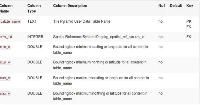
A small part of the GeoPackage metadata can be queried straight from the SQLite data without parsing any XML. This small subset of metadata represents the bare minimum metadata for tiles and pyramid structures so they can be visualized correctly without parsing any XML (and thus increasing the complexity of a potential client).
Figure 3 - Basic metadata available for a pyramid structure
Figure 4 - Basic metadata available for a zoom level
5.3 Elevation Surface Model 5.3.1 Introduction
Elevation Surface Model (ESM) is a Terrain Exchange Standard currently being developed by the Defense Geospatial Information Working Group (DGIWG) [4]. The specification builds on the ISO 19123 standard for Terrain Coverage.
5.3.2 Data
ESM can contain Terrain Data in 4 different formats: Grid Coverage
TIN Coverage
Point Coverage
5.3.2.1 Grid Coverage
Figure 5 - Example of a grid coverage
A grid coverage in ESM refers to pre-defined grid in which elevation points are stored. Once the grid has been defined, elevation values are defined as an array of elevation values. The index or the elevation determines its location in the grid. This allows for a very efficient compression to be applied. A grid also defines its
interpolation value between grid-points
5.3.2.2 TIN Coverage
Figure 6 - Example of a TIN coverage
A TIN coverage in ESM defines a terrain through a series of connected triangles. The edges of the triangles are all geospatially referenced. A TIN-Coverage has the
advantage of easily and efficiently being visualized in 3D environments. The
disadvantage of working with this type of data is that it is often more difficult to use in analysis. The edges of a triangle are not necessarily aligned in a grid, which means that obtaining elevation values for examination requires an advanced client capable of going through a large number of points to interpolate a single elevation value.
5.3.2.3 Point Coverage
5.3.2.4 Point Cloud
A point cloud is a set of points. This is usually the output of sensor data, such as a LiDaR sensor. This special case of data representation is not a coverage, and further processing will need to be done (such as adding metadata) to be usable in an
application.
5.3.3 Metadata
ESM mandates that all metadata is encoded using an XML file that is in compliance with the metadata encoding rules described in ISO 19139. The metadata elements are derived from ISO 19115 and requirements set by the DGIWG Metadata Foundation (DMF).
An overview of all available metadata elements can be found in Annex C. The metadata elements fully cover the requirements set by ICAO Annex 15 and ADQ. Annex C gives a good overview of the complex nature of the ESM metadata model.
On top of the elements defined in Annex C, ESM also allows inclusion of additional metadata elements. The rules for creating extensions are described in the DMF.
Apart from the metadata elements itself, ESM also defines a metadata hierarchy. At the highest level exists the metadata that is relevant for the entire dataset. Additional metadata elements can be added or overridden at lower levels. This allows specific elements of the ESM model (such as high-resolution tiles) to supersede their less detailed counter-parts at a higher level.
5.4 Comparison
5.4.1 Compliance with ICAO Annex 15 and ADQ
Compliance with ICAO Annex 15 and its European derivative ADQ is considered as one of the primary requirements for a candidate terrain exchange format for aviation.
The following requirements can be considered relevant for the choice of a data format:
1. Data set specifications: terrain data shall include a number of metadata items (see section 4), so the format should provide the means to define this
metadata. All evaluated formats provide these capabilities; the following section discusses this topic in more detail.
2. Data exchange format requirements: terrain data shall be expressed using a common format compliant with a specific list of ISO standards, including ISO 19107 (general document, spatial characteristics for geographic data, used by GML etc.), ISO 19115 (metadata model in UML), ISO 19139 (XML encoding of ISO 19115), ISO 19118 (UML modeling & XML schema conversion) and ISO 19136 (GML). Although not all evaluated formats directly use some of these standards (e.g., TIXM in its current form does not yet rely on ISO 19115 or GeoPackage does not directly depend on GML), there are no compliancy issues identified.
3. Data quality requirements: all surveyed data shall be referenced to WGS 84; additionally, a geoid model shall be used in order that all vertical data
by WGS 84, which is probably the most commonly used geodetic reference systems. All formats support representing data in this system.
4. Data protection requirements: all data transformed in an electronic format shall be protected against loss of alteration of data by the application of the CRC32Q algorithm. None of the evaluated formats provide explicit
capabilities for this; however, one approach could be to embed a CRC in the metadata – for instance, through an extension of ISO 15115 / 19139. With this approach, all evaluated formats are considered to be compliant with the requirement.
5.4.2 Support for metadata (ISO 19115)
Good metadata is necessary for a format to comply with ICAO Annex 15 and ADQ. One of the main requirements is the use of ISO 19115 / 19139.
The TIXM format is mostly a metadata format. The metadata definition is an activity that is still underway so no definite statement can be made. It is the intent to specify a terrain data profile as an extension of ISO 19115 / 19139 which would fit the
requirements. Additionally, since a TIXM file can refer to an external file and because many common formats (e.g., GeoTIFF) are multi-leveled, it would be desirable to have some metadata in this regard. For instance, less detailed levels may be derived from more detailed data using by taking an average or a maximum.
GeoPackage supports any type of auxiliary metadata. This can for example be used to embed the metadata that will be defined for TIXM. This metadata can apply to either the entire data set or a subset of tiles. Since the auxiliary metadata is optional it would be necessary to specify additional requirements for GeoPackage files with terrain data in the aviation context.
Similar to GeoPackage, ESM allows metadata for the entire data set and a subset of tiles. The metadata elements (see Annex C) defined in the Elevation Surface Model are based on ISO 19115 and DMF requirements. They fully support ICAO Annex 15 and ADQ requirements in terms of the content of metadata. ESM also mandates the use of ISO 19139 compliant XML to encode the metadata.
5.4.3 Support for usage in OGC services
The OGC web service standards such as WFS, WCS, WMS and WMTS offer an open, standardized and interoperable way to distribute geographical data and are widely adopted by the industry. Integration of the terrain formats into these services is therefore considered as important for the distribution of terrain data.
For the distribution of elevation data, an OGC WCS service seems the most promising. It is specifically designed for the exchange of gridded coverages, and offers numerous parameters to configure this (e.g., resolution, interpolation, defining a subset, etc.). Although GeoTIFF is defined as default exchange format for the WCS, any other format can be plugged in, including TIXM, GeoPackage or ESM. For a TIXM file with external data, a multi-part response is required since both the metadata and the external file need to be communicated. A GeoPackage file on the other hand is fully self-contained so distribution is easy. Data in the DGIWG ESM standard could also be used with a WCS, similar to TIXM data.
Finally, a TIXM file with embedded data fits naturally with an OGC WFS due to its GML nature. However, an OGC WFS is primarily designed for the exchange of vector features and not for gridded coverage data; also, none of the evaluated formats support a vector representation of elevation data (e.g., contour lines), so we primarily focus on a WCS for this topic.
5.4.4 Completeness
Depending on the use case different data representations may be more suitable. A point cloud is more suitable for storage of the raw surveyed terrain data since it leaves the data unmodified. Applications that process, analyze or use terrain data in general on the other hand typically work most efficiently with grids due to their regular nature.
The TIXM format supports both point clouds and grids. Similarly the GeoPackage format also supports point clouds and grids. However, a new extension is needed to add support for elevation data. Adding such an extension such not pose any problems and has already been investigated by the OGC GeoPackage SWG and in OGC OWS-9. The DGIWG ESM standard is more comprehensive: it also supports TIN's in addition to point clouds and grids.
5.4.5 Scalability
In case of large data sets, efficient decoding and handling is crucial for scalability. This requires support for selective decoding (tiling) of data and availability of aggregate data (multi-leveling):
Selective decoding ensures that the memory and processing for applications is proportional to the working set instead of the entire data set. As an example, take an image of 10k x 10k pixels. Reading a block of 256x256 pixels from this image would require decoding ~2.5M pixels if the data is stored in scanline order compared to ~65k pixels for the case where the image is tiled. Availability of aggregate data allows applications to efficiently operate on
both small and large portions of the data set. This allows trading accuracy for speed as needed. It enables a user to get a quick overview based on aggregate data and to subsequently launch highly accurate processing on a region of interest. As an example, take again an image of 10k x 10k pixels. If a user wants to do a quick analysis on the entire data set, this would require processing 100M pixels. However, if a smaller thumbnail of 1k x 1k is available, the application can use this to provide faster feedback at reduced accuracy. A common approach is to store multiple levels of detail of the data in the file where each version is half the size in each direction compared to the previous. Typically this increases the file size by about 1/3 but greatly
increases the possibilities in an application.
A common approach is to use a combination of tiling and multi-leveling, such as in OGC WMTS and GeoPackage.
A second factor is support for sparse data sets, meaning that some areas may contain more detailed data than others. This is especially relevant for data sets covering a large area. Somewhat related to this: the file format itself can also limit the maximum data set size.
data sets or as an intermediate format. A TIXM file can also refer to an external data file so scalability can be obtained by selecting a good external format. A good example is GeoTIFF, a widely accepted format.
Support for tiling, multi-leveling and sparseness is an integral part of the GeoPackage format. Since it is backed by a database, retrieving a subset of the data is very
efficient. From a technical point of view, a GeoPackage database is limited to 140TB; however, it still remains to be tested what the practical upper limit is. Current
scalability tests only used data sets of up to a few 100's of GB.
The ESM standard also allows external data files so similar to TIXM this format. Some suggested formats are GeoTIFF, DTED, NITF and JPEG2000, which all support both selective decoding and aggregate data and would hence be considered scalable.
5.4.6 Industry adoption potential
Industry adoption depends on the effort all parties need to invest into using the format. For software component developers, important factors are the data encoding and complexity of the data representation. For the encoding, re-use of widely support file formats reduces the effort significantly. For the data representation, regular data structures such as grids are typically easier to support than irregular data structures such as triangle networks and point clouds. For data providers, an important factor is the integration with existing data.
TIXM is a new format but its schema is relatively simple and reuses many elements from GML which is a widely accepted format. More work is currently under way to define a more complete profile so this could change in the final version. A TIXM file can refer to existing terrain data so there is no need to translate existing data. Because of this, the adoption cost for both the data provider and software component providers is relatively low. However, since any format can be used to represent the actual data there is a risk for fragmentation. Each software component provider may support a different set of formats for the external data which may severely limit the
interoperability in practice or even make it impossible in the case of proprietary formats.
The GeoPackage format is already a widely accepted OGC standard. Numerous commercial and open-source software components (GDAL, Luciad’s open-source libgpkg library …) already support the standard. Consequently, software component providers should have little effort adopting it for terrain data as well. Allowing terrain data as point clouds is possible but will face slow adoption due to the complexity of handling irregular data. On the other hand data providers will need to translate existing data into the new format.
5.4.7 Conclusion
5.4.7.1 Recommendations
For the metadata, the definition of an ISO 19115 / 19139 profile specific for terrain data would satisfy the ICAO Annex 15 and ADQ requirements. This activity should be underway in the context of TIXM. From an application perspective, the following metadata would be recommended:
Metadata regarding the exact interpretation of a value/pixel: for example elevation, located at the corner of a grid.
Metadata regarding multi-leveling: for levels that are derived from others, which function is used (for example averaging or maximum)
For the data representation, 2 important use cases can be identified. A first use case is the storage of the unprocessed measurement data. The unprocessed data is typically not used directly for analysis. Keeping this data is still important to generated gridded data with minimal loss of accuracy. For instance, when new measurement data is available for a part of a grid. Since such data is typically irregular, it requires support for point clouds in the format. The second use case is analysis. Typically, analysis applications prefer gridded data because it is a very efficient representation for a wide range of analysis algorithms. This is mostly due to its simple, regular structure.
Another representation is a TIN. Such data is efficient for very specific cases (e.g., 3D visualization) but much more complex in many other cases (e.g., retrieving the value at a specific point) due to its irregular nature.
Because terrain data sets can be large, the data format should support both selective decoding and aggregate data. The first allows efficient use of a subset and the latter allows trading accuracy for performance when interactivity is desired. The most widely accepted approach for this is the use of tiling and multi-leveling (e.g., WMTS and GeoTIFF). Another approach is the use of wavelet encoding such as in JPEG2000 but these pose a risk for industry adoption due to their complexity. As a result, there are only a limited number of reliable implementations available, none of which are open source.
For very large terrain data sets (e.g., multiple GB) support for sparse data in the data format is desirable. This can reduce both the bandwidth usage and application memory and processing requirements significantly.
5.4.7.2 TIXM
In general, given the metadata profile that is underway, the TIXM format would suit the requirements. However some improvements may be possible.
Firstly, allowing terrain data embedded as XML does not seem very useful. To get reasonable bandwidth use, application performance and memory usage in practice, this is only feasible for very small data sets. Allowing this capability poses a risk since data can be created which cannot be handled efficiently.
profile should also include the required structure of general formats. For example, the TIFF format can support any number of levels and image format. For this case, we should require tiled data and enough levels of detail to meet the scalability
requirements.
5.4.7.3 GeoPackage
The use of GeoPackage for terrain data requires a new extension. Adding such an extension is supported by the format so this should not pose any problems. The same metadata as used in TIXM can be embedded in the GeoPackage file. However, GeoPackage offers a number of advantages compared to TIXM with an external data file:
It is already a widely accepted OGC standard.
It is a scalable format due to its support for tiling, multi-leveling and sparseness.
It is a single self-describing file which eases distribution.
5.4.7.4 ESM
From a high level the DGIWG ESM standard is similar to TIXM, also allowing both embedded and external data. However it suggests a number of complex features which pose a considerable risk for industry adoption: data representation using a TIN, specific tile ordering schemes and JPEG2000.
6 Analysis of Cross-Border Differences in Terrain Data
Today each state is responsible for the provision of terrain data for its territory. But rarely aviation customers are interested in obtaining data from separate states and then compiling it. For example, an aerodrome located near a country border requires data from both states. Consequently, of more interest is to obtain directly a regional (for example European) or global dataset.
6.1 Creation
Obtaining a seamless terrain for a large area inevitably requires integrating measurement data from different sources that does not line up perfectly with the desired terrain grid. Consequently, some processing on the measurements such as reference transformations, interpolation or combining of samples will be necessary in general. Each of these steps may result in some loss of accuracy.
The desired processing steps depend on the context. For example, a maximum terrain surface (e.g., the actual terrain surface is always below it) is more useful when using the terrain itself as an obstacle, while mean values provide a better results for other applications such as visual inspection of on-terrain obstacles or line-of-sight computations.
In addition access to lower resolution versions of the terrain data set is often also useful to allow trade-off between accuracy and performance.
6.2 Approaches
1. Centralized: Collect measurement data from each state and select a central authority to integrate this into a seamless terrain data set
2. Per state: Define the grid of the terrain data set and assign each node to one of the states
3. Per client: Integrate data from each state on the client
6.3 Centralized
The desired area of the terrain data set is split up and each part is assigned to a state. Each state is then responsible for collecting data for the assigned area meeting all requirements (e.g., precision, resolution, updates ...). This data is gathered by a central authority which verifies and combines it into the desired seamless terrain data set(s).
The accuracy requirements for the data measurements should be somewhat higher than the accuracy required by the seamless data set since the central authority will need to do some processing on it which typically reduces the accuracy. Individual states are also not required to process the data into a single grid since the central authority takes care of this. The provided data could for example be in the form of a point cloud (e.g. a disordered set of geographic locations and height measurement tuples).
An important advantage of this approach is that it ensures all data is verified and processed in the same way. Since the central authority has all data available it can also easily compute aggregate sets (e.g., lower resolution versions of the data) or different variations (for example min/mean/max value). Overlap between the measurements of the different states does not pose any additional problems since it is handled naturally as a part of the processing by the central authority.
6.4 Per state
The states agree upon the grid and geographic reference of the seamless terrain. Each node of this grid is assigned to a single state. Each state is then responsible for collecting data for its assigned area and processing it to obtain the terrain height at each node.
By using a pre-defined grid, the horizontal position of each node is clearly defined and the data from all states aligns perfectly. In addition, by assigning each node to 1 state, we ensure that there is no problem of overlap or holes. Each client can load the required state data sets to form a seamless data set. This requires no processing or transformation on the client, so there is no risk of introducing inaccuracies. However, this approach does not ensure perfect alignment of the vertical position of the data of different states. Each state might do its own measurements or process the data in different ways. So the transition from one state's data to another can be visible (e.g., a 'wall' at the border). This could be objectionable when the data is used for
visualization. This does not introduce any problems when using the data for processing: since each state guarantees that its data satisfies the vertical accuracy requirements, the size of the discontinuity must also be small. For example, a vertical accuracy requirement of ±1m can result in a discontinuity of at most 2m.
6.5 Per client
This approach gives each client the freedom to process and transform the data in a form that it finds most suitable. Performing reference transformations and on-the-fly grid re-sampling should not pose any problems from a technological point of view. Computing aggregate data sets on the other hand is typically done in a preprocessing step. A potential risk of this approach is that clients are not familiar with the potential problems when processing data such as accuracy loss. For example, when performing a reference transformation the nodes in the target grid do not line up perfectly with the nodes in the source grid so some horizontal accuracy is lost.
7 Analysis of Web-Based access to eTOD data in an INSPIRE compliant way
7.1 Introduction
INSPIRE or Infrastructure for Spatial Information in the European Community is an initiative launched by the European Commission to integrate and harmonize the representation and delivery of geographical information provided by the member states. Its goal is to facilitate the discovering, accessing and sharing of public sector data in a much more standardized way allowing the sharing of information within public and private sector organizations and with the citizen. The INSPIRE initiative is part of the wider EU Digital Agenda for Europa / Europe 2020 strategy, which sets out a vision for a digital Single Market to give people access to all the potential advantages of the digital society.
7.2 Relevance for the terrain data representation and access
Elevation is one of the 34 spatial data themes identified within the INSPIRE Data Specifications [5]. It encompasses digital elevation models for land, ice and ocean surfaces both for terrestrial elevation and bathymetry, as well as shorelines.
Two types of elevation models are identified:
V A Digital Terrain Model (DTM), describing the bare surface of the land or sea floor,
V A Digital Surface Model (DSM), describing the heights of the objects present on the surface (e.g., vegetation, man-made objects)
The following paragraphs discuss the INSPIRE requirements & recommendations for the representation and delivery of elevation data in more detail [6].
7.3 Representing elevation data 7.3.1 Spatial representation
Three spatial representation methods are offered:
V A grid representation, consisting of a coverage geometry & elevation values at the points of a rectified grid.
V A vector representation, consisting of land elevation and bathymetry elements in the form of spot elevations, contour lines, as well as break lines.
The widely used grid representation is considered as the only mandatory
representation to be compliant with INSPIRE. All investigated candidate terrain formats support at least the grid representation.
7.3.2 Coordinate reference system
For Pan-European and cross-border purposes, it is recommended to use a common grid representation based on ETRS89 geodetic coordinates, while using real time re-projection for display through view services. All investigated candidate terrain formats support the use of the ETRS89 geodetic coordinate system.
7.3.3 Vertical datum
Use the European Vertical Reference System (EVRS) for the vertical component on land within continental Europe, and the Earth Gravitational Model (EGM Version 2008) for other areas. All investigated candidate terrain formats support the use of the EVRS and EGM 2008 vertical datums.
7.3.4 Data encoding
Use GML or TIFF as encoding for gridded land-based elevation data; use GML or a BAG file for bathymetric elevation data. TIN data shall be encoded using GML TIN. Additionally, only compression methods are valid that do not lead to data loss. From the investigated candidate terrain formats, both TIXM, GeoPackage and ESM offer compatibility with this requirement:
TIXM directly relies on GML to describe elevation data; additionally, it can also link to an external file in the TIFF format for the actual data.
GeoPackage and ESM are not specifically tied to a data encoding. In GeoPackage, extensions can be easily defined that use TIXM, TIFF, or any encoding format of choice.
7.4 Providing web-based access to elevation data
To provide web-based access to elevation data in an INSPIRE-compliant manner, multiple approaches can be identified that differ in the way the data is delivered and represented.
Providing access to geographical information over the network is described in the Network Services component, one of the five major components within INSPIRE. The Network Services component introduces a number of relevant services, including discovery services, view services, download services and transformation services. For each of these services, requirements and recommendations are defined to deploy them in an INSPIRE-compliant manner.
Most relevant to provide web-based access to terrain data are the download, view and discovery services. The following paragraphs discuss these in more detail.
7.4.1 Access via a download service
Within INSPIRE, a download service enables users to download and access copies of spatial data sets, or parts of such sets. Following the INSPIRE requirements on elevation data representation, the data should at least be offered in a grid
Applied to the use case of accessing terrain data, multiple options are available to package the domain and range encoding of coverage data. One option put forward is the use of a two-part representation, following the multipart representation
conformance class defined in GML Application Schema for Coverages [7]. With this approach, a binary file format can be used in the second part to efficiently encode the range while the first part can rely on GML to represent the domain, fully compliant with ISO 19123. For small datasets, GML might alternatively also be used for the range encoding. The default binary encoding for the coverage range is TIFF, while the default GML encoding for the coverage domain (and optionally the range) is GML 3.2.1.
In practice, these requirements perfectly map on the OGC WCS 2.0 web service standard. OGC WCS 2.0 is based upon the coverage standard ISO 19123 and already relies on the GML Application Schema for Coverages for its representation. Within the WCS, the description of the coverage domain is handled by the DescribeCoverage request. Users can execute this request for a given coverage ID. The response contains (amongst other metadata) a description of the coverage domain, relying on the GML Application Schema for Coverages. To retrieve the actual data of the range (i.e., the range encoding), the GetCoverage request is used. The default format for this encoding is GeoTIFF, which is in line with the default binary encoding defined by INSPIRE, but others can be used. In fact, all investigated terrain data formats in this document are considered to be compatible, because the only requirement is to be able to encode the coverage range; the coverage domain description is already handled by the WCS DescribeCoverage operation.
7.4.2 Access via a view service
INSPIRE defines a view service as a network service that can be used for portrayal of spatial data. This is modeled by layers that portray spatial object types, and associates styles that define their portrayal. A grid elevation coverage is considered as one spatial object type, and should be identified by a layer and style with the following characteristics:
V Layer Name (identifier) = EL.GridCoverage
V Layer Title (human-readable name) = Grid Coverage
V Keywords = grid, coverage
V Style = an OGC Symbology Encoding specifying a raster symbolizer that maps the elevation values onto colors (see Annex B).
In practice, these requirements can be implemented by using the OGC WMS 1.3.0 or the OGC WMTS 1.0 web service standards. Both services offer portrayal capabilities to the user; the main difference is in the retrieval of the maps: WMTS is a tiling protocol and relies on tiling parameters (tile pyramid, row, level, column) to identify maps (tiles), whereas WMS expects a bounding box and resolution from the user to identify a map. If performance is key, OGC WMTS is the recommended standard to set up a view service. OGC WMS can be considered if more flexibility is needed: it allows users to request the data in any geographic reference (if supported by the server) together with user-defined styling (if the server supports the OGC SLD profile for WMS).
compression format such as PNG should be used. In practice, a view service will typically access terrain data use one of the candidate terrain data formats, either directly from files or from a download service as described in 7.4.1.
7.4.3 Discovery service
A key concept in the INSPIRE network services is the discovery service, enabling users to discover, browse and query data made available by the previously discussed services. Applied to the the use case of accessing terrain data, a discovery service could be used to discover which terrain data sets are made available and their quality characteristics.
A practical implementation of a discovery service can be found in the OGC Catalogue Service 2.0.
7.4.4 Updates
INSPIRE also requires that member states provide updates of data on a regular basis. All updates should be made publicly available 6 months after the changes were applied to the source data set.
8 Conclusion & recommendations
This document provided an assessment of the exchange of terrain data sets, including an identification of possible formats, an identification of possible ways to overcome the cross-border differences in terrain data and an identification of possibilities for web-based access to terrain data in an INSPIRE compliant way.
8.1 Terrain data formats
The formats TIXM, OGC GeoPackage and ESM have been selected as candidate terrain exchange formats and evaluated on a number of criteria.
All three formats can be considered as compliant with ICAO Annex 15 and ADQ, but some formats offer more out-of-the-box capabilities to support their requirements. Specifically from the perspective of metadata requirements, the definition of an ISO 19115 / 19139 profile specific for terrain data would be recommended; this activity should already be underway in the context of TIXM, a format specifically designed to comply with ICAO Annex 15 and ADQ. From an application perspective, additional metadata regarding the exact interpretation of a value / pixel and regarding the multi-leveling structure is recommended.
To distribute gridded elevation data, an OGC WCS service is considered most suitable, as it has specific parameters that apply to exchanging grid coverages (e.g., resolution, interpolation, defining a subset, etc.). Although GeoTIFF is defined as default exchange format for the WCS, any other format can be plugged in, including TIXM, GeoPackage or ESM. An OGC WMTS service is more suitable to make a gridded elevation data set available to applications since it typically provides better performance for many, fine-grained requests.
From a completeness perspective, the ESM standard is considered to be the most comprehensive (grids, point clouds, and TINs), followed by TIXM (points clouds and grids) and then GeoPackage (points clouds and grids, but a new extension for
For optimal scalability, a terrain data format should preferably support selective decoding, aggregate data and sparseness. Selective decoding allows efficient use of a subset of the data, aggregate data allows trading accuracy for performance when interactivity is desired and sparseness helps reducing bandwidth usage, application memory and processing requirements. On this topic, GeoPackage format is considered very promising. Being backed by a database, it offers direct support for selective decoding (through tiling), aggregate data (through multi-leveling) and sparseness. For TIXM and ESM, the capability to reference external data files also allows choosing a scalable elevation encoding format; the formats GeoTIFF, DTED and NITF are considered suitable for this use case, as they offer similar capabilities as GeoPackage.
From an industry adoption potential, OGC GeoPackage is a clear winner. Although it is a relatively new OGC standard (early 2014), it is already supported (or will be in the near future) by numerous commercial and open-source software vendors. The TIXM format is not yet final, but it also has potential for quick adoption: the format is relatively simple and based on well-known and widely adopted standards such as GML, and it offers to reference existing data formats for terrain data encoding. The ESM standard is also still being developed; at the time of writing, it is the most comprehensive format but also the most complex, which poses a risk for industry adoption.
8.2 Cross-border differences in terrain data
An investigation has been performed on the topic of providing seamless terrain data to the user, avoiding potential cross-border elevation differences. Three approaches have been investigated: (1) processing of terrain data by a central authority, (2) the use of a fixed terrain grid across multiple states and (3) shifting the responsibility to the client applications to integrate the data of different states into a seamless terrain. No clear recommendation can be made here; all approaches have advantages and
disadvantages, which should be evaluated by all stakeholders to decide on a particular approach.
8.3 INSPIRE-compliant, web-based access to terrain data
The main goal of the European INSPIRE initiative is to harmonize the representation and delivery of geographical information by the member states. Applied to terrain data, a number of requirements and recommendations are identified related to the representation and delivery of the data.
For compliancy with INSPIRE, a grid representation should at least be offered, which is in line with the recommendations made in terrain format evaluation part.
Furthermore, it is recommended to use a common grid based on ETRS89 geodetic coordinates for Pan-European and cross-border purposes. Additionally, the EVRS vertical datum needs to be used to express gravity-related heights; while ICAO Annex 15 and ADQ dictate the use of EGM 2008, INSPIRE only recommends this for
territories outside continental Europe. From the perspective of data encoding, GML or TIFF is recommended to be used for grid elevation data. Looking back to the
evaluation of terrain formats, this would vote for the use of TIXM in combination with embedded terrain data in GML or a reference to TIFF (preferred for scalability reasons).
Annex A
TIXM XML Schema Documents
This Annex embeds the XML Schema Documents that define the TIXM format. This includes the root XML Schema, TIXM.xsd, the XML Schema defining the core TIXM classes and features, TIXM_Features.xsd, and the XML Schema defining TIXM data types and enumerations, TIXM_DataTypes.xsd.
TIXM.xsd
<?xml version="1.0" encoding="UTF-8"?> <!--
Project:
Terrain Data Exchange Model Owner:
EUROCONTROL, Rue de la Fusee, 96, B-1130 Brussels, Belgium Summary:
This XSD file constitutes part of the EUROCONTROL Terrain Exchange Schema.
Copyright: EUROCONTROL.
Reproduction is authorised, provided the source is acknowledged. The data is provided on an
"as seen / as is" basis, and is intended for testing purposes only. The EUROCONTROL
Agency provides no express or limited warranty of any kind, including but not limited to
those of merchantability, fitness for a particular purpose and accepts no liability whatsoever
for or in connection with the use of the data. -->
<schema xmlns="http://www.w3.org/2001/XMLSchema" xmlns:tixm="http://www.eurocontrol.int/tixm" targetNamespace="http://www.eurocontrol.int/tixm" elementFormDefault="qualified"
version="1.0"> <annotation>
<documentation>EUROCONTROL Terrain Model</documentation> </annotation>
<include schemaLocation="TIXM_Features.xsd"/> <include schemaLocation="TIXM_DataTypes.xsd"/>
</schema>
TIXM_Features.xsd:
<?xml version="1.0" encoding="UTF-8"?> <!--
Project:
Terrain Data Exchange Model Owner:
EUROCONTROL, Rue de la Fusee, 96, B-1130 Brussels, Belgium Summary: