MULTI-SENSOR NETWORK FOR LANDSLIDES SIMULATION AND HAZARD
MONITORING - DESIGN AND DEPLOYMENT
Wu Hangbin a,b,*, Qiao Gang a,b, Lu Ping a,b, Feng Tiantian a,b, Tian Yixiang a,b, Fan Hongchao a,b, Liu Shijie a,b, Liu Chun a,b, Tong Xiaohua a,b, Wang Weian a,b, ShenYunzhong a,b, GuanZequn a,b, LiRongxing b,c
a
Department of Surveying and Geoinfomatics, Tongji University, P.R.China.-([email protected])
b
Centre for Spatial Information Science and Sustainable Development, Tongji University, P.R.China c
Mapping and GIS Lab, The Ohio State University- [email protected]
KEY WORDS:Landslides, Multisensor, Acquisition, Monitoring, Networks
ABSTRACT:
This paper describes a newly developed multi-sensor network system for landslide and hazard monitoring. Landslide hazard is one
of the most destructive natural disasters, which has severely affected human safety, properties and infrastructures. We report the
results of designing and deploying the multi-sensor network, based on the simulated landslide model, to monitor typical landslide
areas and with a goal to predict landslide hazard and mitigate damages. The integration and deployment of the prototype sensor
network were carried out in an experiment area at Tongji University in Shanghai. In order to simulate a real landslide, a contractible
landslide body is constructed in the experiment area by 7m*1.5m. Then, some different kind of sensors, such as camera, GPS,
crackmeter, accelerometer, laser scanning system, inclinometer, etc., are installed near or in the landslide body. After the sensors are
powered, continuous sampling data will be generated. With the help of communication method, such as GPRS, and certain transport
devices, such as iMesh and 3G router, all the sensor data will be transported to the server and stored in Oracle. These are the current
results of an ongoing project of the center. Further research results will be updated and presented in the near future.
* Corresponding author.
1. INTRODUCTION
Landslide hazard is one of the most destructive natural
disasters, which has severely affected human safety,
properties and infrastructures. Traditionally, to monitor
landslide and avoid human and properties loss, 3S technique
has been successfully applied in landslide research (Tan et al.,
2003). However, landslide is a complicate system. The
traditional terrain data sources, such as slope, aspect, land
cover etc., which are generated by 3S technique, could not
represent the whole geometrical and physical characteristics
of landslide. Some other data sources, such as geological data,
are also playing important roles in landslide study. Moreover,
landslide is a dynamic and moving system, while mutative
events, such as precipitation and earthquake, will usually
provoke the landslide in a short time. Therefore,
meteorological and external mechanical data are also vital for
landslide research. Simulating the landslide related data is an
important work in landslide study. Therefore, sensor
networks are always used to monitor the landslide.
A sensor network is a communication infrastructure or group
of specialized transducers to monitor, record and respond to
any phenomena or diverse locations (Rahman, 2010).
According to the style of sensor, the sensor network
established in our project can be divided into wireless sensor
network and wired network, or geospatial sensor network and
non-geospatial sensor network (Verdone et al. 2008,
Stefanidis and Nittel., 2004). Due to the large count of sensor
is complicated. Therefore, it is necessary to build and create
the sensor network for landslide monitoring.
3D digital landslide simulation based on multi-sensor
network is a new method to analyse landslide numerically,
visually and repeatedly (LI Xianhua et al., 2003). It constructs
the landslide body by certain scale and under geological
condition. Then spatial and non-spatial sensors are placed in
or near the landslide body to observe and monitor the whole
landslide. By sensors’ output, not only terrain data, such as
imagery, DEM, GPS etc., but also the mechanical, geological,
pedological, meteorologic data will be collected and recorded.
Combining the terrain data with non-spatial data, mechanical,
geological, pedological, meteorologic data, the status of the
landslide body can be directly expressed in 3D landslide
model. Moreover, some high frequency sensors, such as
high-speed camera and accelerometer, will record the
evolvement of landslide in incredible detail. Therefore, 3D
digital landslide simulation provides researchers a direct and
dynamical way to observe the landslide status, analyze
mechanical parameters of soil and rock, determine the rules
and relationship between landslide and corresponding
environmental key factors, and accumulate evolved
knowledge of landslide. It can be used both in landslide
research and prediction.
In this paper, we report the results of designing and deploying
the multi-sensor network for landslide monitoring based on
simulated landslide model, for the purpose of predicting
landslide hazard and mitigate damages. The integration and
deployment of the prototype sensor network were carried out
in an experiment area at Tongji University in Shanghai. After
the system is tested, it will be modified and moved to a larger
scale slope in Wenchuan, where landslide hazards are severe
and frequent problems. Currently, the landslide body was
built in Tongji campus and more than ten kinds of sensors are
installed in or near the landslide body.
2. FLOWCHART OF THE LANDSLIDE SIMULATION AND HAZARD MONITORING
PROJECT
There are totally three parts in our landslide monitoring
project. It can be seen in Figure 1. The first one is the
establishment of the multi-sensor network. During this step, a
scaled-down landslide body is also designed and deployed in
order to provide location and area for the sensor network
installation. The second part is real-time data acquisition and
landslide monitoring. All the sensors are powered to generate
the sensors’ observations and then, transferred to a database to
record the real-time data. The last step is to manage and
analyze the sensor data to evaluate the landslide status by
changing the precipitation and other landslide triggering
factors. The first two parts have been finished in our project
currently.
Figure 1. Flowchart of the landslide simulation and hazard
monitoring project
3. SCALED DOWN LANDSLIDE BODY SIMULATION AND MULTI-SENSOR MONITORING
NETWORK
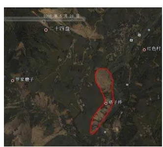
Figure 2. Hongkou landslide area in Sichuan Province
In our project, we are about to simulate the real landslide in
Hongkou Town, Dujiangyan City, Sichuan. After Wenchuan
earthquake, several landslide events have been happened.
In our project, a scaled down landslide will be designed and
created to install the sensor work.
3.1 Simulation of landslide body
Simulation of landslide body is carried out to simulate the real
landslide body based on the similar characteristics such as hill
slope and soil features with Hongkou landslide. The purpose
of the landslide body simulation includes, an imitation of
landslide monitoring sensor network based on the
space/air/ground – borne sensor; a test of the sensor
parameters such as level of sensitivity, accuracy, and
applicability induced by rainfall; an initial landslide sensor
network performance evaluation for the synergistic
observation of sensors, correlation of the multi-source data,
real time monitoring, and the visualization of the remote
sensing data.
The landslide platform is located at the surveying and
mapping experiment department, Tongji University,
Shanghai. The space for the platform is 15m long and 8m
wide, thus the landslide platform is designed as 7m by 1.5m.
To better simulate the 20-40 degrees slope angle of the
landslide mass in Hongkou Town, the landslide platform is
designed into three parts, while the slope angle of each part is
30 degree, 15 degree, and 5 degree respectively. The layout of
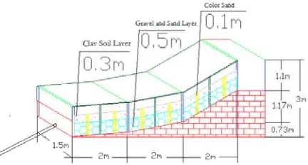
the landslide platform is shown as Figure 3.
Figure 3. The layout of the simulated landslide platform
The platform is built with red bricks as its foundation, and the
tempered glass of 2cm width to contain the landslide mass.
Steel frame is installed and fixed around the tempered glass
for the security purpose. Each part of the landslide platform is
2m in length, and 1.5m in width. With the three angles of 5
degree, 15 degree and 30 degree, the highest part of the
platform is thus 3m. There is a terrace of 3m by 1.5m by 1m at
the rear of the platform for settling down the transducers of
the sensor network. Water supply system is mounted on the
steel frame to simulate the rainfall environment for the
landslide test, and a drainage system is designed to deal with
the waste water.
To simulate the dense gravel and loose soil characters of
Hongkou Town, the landslide mass is divided into two layers:
the 0.5m height gravel and sand layer at the bottom, and the
0.3m height clay layer at the top. The gravel and sand layer is
composed of clay, sand, and gravel with a proportion of 1:1:5,
while for the clay layer, clay and sand with a proportion of 1:3.
To monitor the internal slide of the landslide mass, a 0.1m in
diameter color sand bar is arranged at outer side of the
tempered glass every 1m.
3.2 Landslide monitoring sensors distribution
In order to observe al and physical parameters of landslide
body, a spatial and non-spatial sensor network was built to
measure the unstable factors that might potentially trigger the
landslide. In addition, it provides help to understand the
evolution of mass movements, and to offer a reliable
prediction regarding the future behavior of the landslide. As a
result, this spatial and non-spatial sensor network is designed
as a real-time system for a monitoring at different stages of
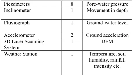
landslide processes. The name, count and its monitor target of
sensors and instruments adopted in this paper are listed in
table 1. The horizontal and Longitudinal distribution of
sensor are shown in Figure 4 and Figure 5.
Name Count Monitor target
Wireless Video
1 Temperature and
humidity
Crackmeter 1 Surface crack
Drilling Dynamometer 1 Pressure of mass movement Anchor Dynamometer 1 Tensile stress Large Range
1 Surface failure
Piezometers 8 Pore-water pressure
Inclinometer 1 Movement in depth
Pluviograph 1 Ground-water level
Accelerometer 2 Ground acceleration
3D Laser Scanning System
1 DEM
Weather Station 1 Temperature, soil humidity, rainfall
intensity etc.
inclinometers measure ground displacement at the depth of
the landslide. Also, a ground-based SAR (GB-SAR) was
settled in front of the landslide body so as to estimate
displacements from interferometric characteristics of SAR
measurements. Second, the system focuses on a monitoring of
ground water level change. This is completed by piezometer
which measures pore water pressure inside the landslide body.
Third, a total station was used to capture the landslide
geometry such as slope and distance. Fourth, anchor
dynameter and drilling manometer provide measures of
forces vertical and parallel to surface movement. Finally, a
wireless temperature and humidity sensor, combined with the
weather station, was included to monitor the in-situ
conditions such as temperature, humidity and rainfall
intensity. It should also be noticed that a high-speed camera
was used to capture the moment of landslide failure. Table 1. The equipment used for landslide monitoring caused
by external force
Most of the monitoring data was collected in the Data Taker
due to its maneuverable. Some other sensors, such as
accelerometer,
Inclinometer
and wireless network camera, were collected by other methods or devices. The procedure ofdata collection and transportation will be introduced in
Section 4 of this paper.
Figure 4. Horizontal sensor distribution in or near the
landslide body
4. DATA COMMUNICATION AND STORAGE
The data captured from all the sensors will be used to evaluate
the status of the landslide body, thus the data should be
transferred from the field to database initially. In our
experiment, the simulated landslide body is located in the old
Surveying Building at Tongji University, and the
database(Oracle 11g) is built in the new Civil Engineering
Building, and therefore, we need to transport the sensor data
to the database.
In our experiments, all the sensors could be divided into three
types: narrowband high frequency sensors(eg: Accelerometer,
up to 80HZ), narrowband low frequency sensors(eg: Large
range displacement meter) and broadband sensors(eg wireless
video surveillance). In order to reduce the influence of
tran-sportation of these sensors, different ways of communication
are employed. The sketch of data communication for Figure 5. Longitudinal distribution of sensors
In detail, the layout of this spatial sensor network aims at 5
observation factors. First, it provides a real-time monitoring
of displacements. This is fulfilled through displacement meter
Figure 6. Diagram of sensor data communication
4.1 Narrowband data communication
3G and GPRS methods are firstly used to transport the
narrowband sensor data, when GPRS method is used to
transport the data captured by Data Taker and 3G method is
used to transport the data captured by serial port, Ethernet and
some other methods. With the help of 3G and GPRS network,
public Internet, narrowband sensor data are transported from
sensor to a certain port of database server. The
communication speed of 3G and GPRS can reach to 350k/s
and 30k/s, which is enough for narrowband data
transportation.
Figure 7. Client software for narrowband sensor network data
communication
Client software (See figure 7) is always running to monitor
port status and data stream. In our experiment, port 2002 and
2003 of database server are used for data communication
using TCP protocol. Port 2002 is used to maintain the
narrowband high-frequency data and port 2003 is used to
capture the narrowband low frequency data. Once the sensor
data has been seized by client software, original sensor data
will be divided and then stored in Oracle database.
4.2 Boardband data communication
Another important kind of real time data is the video captured
by camera. In our experiment, two kinds of camera are used to
monitor the whole status of landslide body, high-resolution
and standard-resolution camera. The data volume for
high-solution and standard resolution camera can be reached
to 8M\s and 2M\s. Therefore, narrowband channel cannot be
used to transport video data. Some special instruments, such
as iMesh, are hired to establish a boardband channel for video
data communication.
5. CONCLUSION
From the current establishment of sensor network for
landslide monitoring, we have finished the following work
and got some conclusions:
University to simulate the real landslide. The geological and
topographical characteristics of the landslide body are similar
with Hongkou landslide.
ii. Different kinds of sensors are installed in landslide
body which will help us generate abundant observations for
landslide analysis.
iii. By using 3G, GPRS and boardband communication
methods, all the observations are transferred to database
server in real-time.
In the near future, we will start the work for landslide key
factor analysis and landslide status evaluation on the
simulation landslide body. In addition, more landslide detail,
such as rock crack, megalith, etc., will be simulated in
landslide body to accurately describe the real landslide area.
Then, by using the sensor data and empirical landslide model
and physical landslide model, a series of landslide systematic
tests will be conducted by changing the precipitation and
other landslide triggering factors. Thereafter, the developed
technology will be deployed in a real landslide environment
in the west mountainous region in China.
6. ACKNOWLEDGEMENT
We appreciate the support from 985 National Education fund
and Kwang-Hua fund for College of Civil Engineering,
Tongji University.
7. REFERENCES
Kazi Chandrima Rahman. A Survey on Sensor Network.
Journal of Computer and Information Technology(JCIT),
ISSN 2078-5828.
LI Xianhua, Lin Hui, Gong Jianhua, et al. 2003. Research and
Dig ital Simulation about Digital Landslide Motion.
Geo-Inf-ormation Science. 9(3), pp36-41.
Stefanidis and Nittel (Eds.), 2004. GeoSensor Networks, CRC
Press, Boca Raton, FL (296 pages).
Tan Debao, Zhang Yu, Sun Jiabing.2005 Real 3D Modeling
of Landslide. Journal of Yangtze River Scientific Research
Institute. 22(6). pp67-70.
Verdone, R., D. Dardari, G. Mazzini and A. Conti (2008),
Wireless Sensor and Actuator Networks, Academic
Press/El-sevier, London.