A GIS-BASED MULTI-CRITERIA EVALUATION SYSTEM FOR SELECTION OF LANDFILL SITES: a case study from Abu Dhabi, United Arab Emirates
S. M. Issa* and B. AL Shehhi*
* Geology Department, Faculty of Science, U.A.E. University, Al-Ain, P.O. Box: 17551, U.A.E.
E-mail: [email protected]
Commission II, WG II/7
KEY WORDS: GIS, Landfill siting, Multi-criteria, Solid waste, Site selection, Abu Dhabi, UAE ABSTRACT:
Landfill sites receive 92% of total annual solid waste produced by municipalities in the emirate of Abu Dhabi. In this study, candidate sites for an appropriate landfill location for the Abu Dhabi municipal area are determined by integrating geographic information systems (GIS) and multi-criteria evaluation (MCE) analysis. To identify appropriate landfill sites, eight input map layers including proximity to urban areas, proximity to wells and water table depth, geology and topography, proximity to touristic and archeological sites, distance from roads network, distance from drainage networks, and land slope are used in constraint mapping. A final map was generated which identified potential areas showing suitability for the location of the landfill site. Results revealed that 30% of the study area was identified as highly suitable, 25% as suitable, and 45% as unsuitable. The selection of the final landfill site, however, requires further field research.
1. INTRODUCTION
Evaluation of a new waste disposal site is a complicated process requiring evaluation of many different criteria and considerable expertise in diverse social and environmental fields, such as soil science, engineering, hydro-geology, topography, land use, sociology, and economics(Nair et al. , 2006 ; Chang et al. 2008; Rahman et al., 2008 ; Lunkapis 2010; Nishanth 2010). Environmental factors are very important because the landfill may affect the biophysical environment and the ecology of the surrounding area (Siddiqui et al. 1996; Kontos et al. 2003; Erkut and Moran 1991). Economic factors must be considered in the siting of landfills, which include the costs associated with the acquisition, development, and operation of the site (Delgado et al. 2008; Erkut and Moran 1991; Kontos et al. 2003). Social and political opposition to landfill siting have been indicated as the greatest obstacle for successfully locating waste disposal facilities (Lober 1995). The “not in my backyard” (NIMBY) and “not in anyone’s backyard” (NIABY) attitudes (Chang et al. 2008; Kao and Lin 1996; Erkut and Moran 1991; Kontos et al. 2003; Lin and Kao 2005) are becoming popular nowadays creating a tremendous pressure on the decision makers involved in the selection of landfill sites.
It is evident that many factors, with spatial dimensions, must be combined into landfill siting decisions. Geographic information systems (GIS) are ideal for such studies due to their ability to collect, store, manipulate, process and analyze large volumes of spatial data from a variety of sources (Sener et al. 2006). GIS have the capability to handle and integrate the necessary economic, environmental, social, technical, and political factors and constraints. Furthermore, many of the attributes involved in the process of decision making for the selection of sanitary landfill sites have a spatial dimension, which in the last few years has motivated the predominance of geographical approaches that allow for the integration of multiple attributes using geographic information systems (Kontos et al. 2003; Sarptas et al. 2005; Sener et al. 2006;
Gomez-Delgado and Tarantola 2006; Delgado et al. 2008; Chang et al. 2008).
Multi-criteria evaluation (MCE) is used to resolve conflicts and deal with the difficulties that decision makers encounter in considering large amounts of complex information. The principle of the method is to divide the decision problems into more smaller understandable components, analyze each component separately, and then integrate the components in a logical way (Malczewski 1997). The integration of GIS and MCE is a powerful tool to solve the landfill site selection problem because GIS provide efficient organization and handling of spatial data and MCE supplies consistent ranking of the potential landfill areas based on a variety of criteria (Carver, 1991 ; Sener et al. 2006).
The Emirate of Abu Dhabi has a Strategy that covers the management of all solid waste in the Emirate. The objective of this Strategy is to establish a sustainable world class waste management system to divert polluting waste away from landfill disposal and maximize resource recovery (CWM, 2010). In order to improve waste management across the Emirate, the Government of Abu Dhabi has established the Center of Waste Management - Abu Dhabi (Center or CWM) in December 2008 by Decree (Law 17). The Center is the lead agency responsible for controlling and coordinating waste management activities throughout the Emirate including the policy, strategy and contractual systems (CWM, 2010).
Table 1. Summary of waste situation in Abu Dhabi region (2008/2009). Source: SCAD 2011.
Total population (averaging 2008 and 2009 population)
1,059,957
Amount of municipal waste collected (thousand tonnes/year)
- Average amount of municipal waste per capita (kg/capita-day)
2,540 6.56
Amount of municipal solid waste by destination (thousand tonnes/year)
There is one sanitary landfill, one composting plant, and one incineration plant. Of the 2,540 thousand tonnes of waste collected in Abu Dhabi Municipal area in 2008/2009, 92% was disposed in the controlled Al Dhafra landfill, 7.98% was disposed in sorting and composting plants, 0.02% was burnt in Al Ain incineration plant.
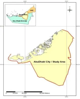
This paper presents the methodology used in the assessment and selection of areas for solid waste landfill using multi-criteria analysis and geographical information systems (GIS). The study area covers the administrative boundaries of the greater Abu Dhabi Municipality, the capital city of the emirate of Abu Dhabi, which is the biggest of the seven emirates that constitute the United Arab Emirates. The study area (Abu Dhabi Municipality boundary) has a population of 1,059,957 producing an average daily waste of about 6,955 tonnes which yields about 2,540 thousand tonnes of wastes annually. The amount of Waste received at waste treatment and disposal facilities is calculated as 6.56 kg. Waste is mostly composed of C&D. Land requirement for the landfill site for Abu Dhabi area is estimated at around 4 sq. km. for a 20-year disposal period (Figure 1).
Figure 1. Study area: Abu Dhabi Municipal area, UAE
2. MATERIALS AND METHODS
GIS desktop software package ArcGIS 9.3 and its extensions were used as the GIS tools since it is able to perform suitability analysis using Multi-Criteria Evaluation (MCE). A multi-criteria evaluation analysis investigates a number of possible choices for a siting problem, taking into consideration multiple criteria and conflicting objectives. In order to use GIS for site selection, the available information for the study area was collected and stored in the geographic information system. All digital maps of the study area including topographical maps were registered to UTM coordinate system, zone 40, WGS84 datum. Data details are fully described and presented in Table 2.
Table 2. Summary of data and data sources used in the analysis
Recent 1:50,000 Department of Municipal
2.1. Siting methodology and criteria
GIS model is based on Boolean operation. It involves the logical combination of binary maps resulting from the application of conditional operators. If the criteria and guidelines have been established as a set of deterministic rules, this method is a practical and easily applied approach. The output is a binary map because each location is either satisfactory or not.
In practice, it is usually unsuitable to give equal importance to each of the criteria being combined. Factors need to be weighted depending on their relative significance. Hence, each location will be evaluated according to weighted common scale (e.g., ranging between 0 to 10, where a score of 0 indicates no constraint and a score of 10 indicates a total constraint). Weights are generally assigned to these maps to express the relative importance. In order for the output map to be meaningful and consistent, map weights have to add up to 100% and the attribute scores have to be chosen using a scheme that is the same for each map.
3. RESULTS AND DISCUSSION
A landfill must be situated and designed so as to meet the necessary conditions for preventing pollution of the soil, groundwater or surface water and ensuring efficient collection of leachate. Similarly, a landfill site should be kept as far away as possible from population density, for reducing pollution impact on public health. On the other hand, the landfill site should be placed as close as possible to existing roads for saving road development, transportation, and collection costs. Furthermore, difficult or steep terrains are not appropriate for hosting landfills.
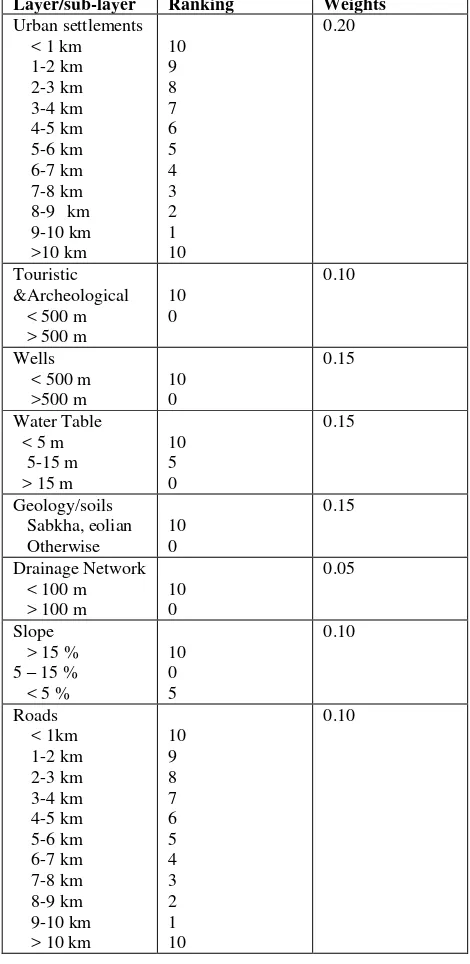
Eight suitability criteria (distance from urban areas, roads network, touristic & archaeological sites, wells, drainage network, water table, Geology, and land slope map) were used in this study and were partly based on the relevant Abu Dhabi Government Regulations, in addition to international practices that account for environmental, economic, social, and technical factors. A map was created for each suitability criterion and a final composite map was finally produced by simple overlaying of the individual maps. The layers, buffer zones used, rankings and layer’s weights are summarized in Table 3. The weights were assessed by taking into account the possibility of modifying the natural conditions of the sites by appropriate engineering interventions, so as to increase their suitability (Delgado et al. 2008). Likewise, criteria that are of less importance to the conditions of the UAE and its climate were given less weights. For example, high weights were given to the urban settlements, wells and water table. On the contrary, drainage network, and the roads were considered less important either, because of absence of water courses due to hyper arid climate of the UAE or, because they can be worked out and modified, if required by a given project. Furthermore, agricultural lands were neglected because the study area is a complete desert where greened areas (e. g., parks, artificial forests, farms, etc.) constitute part of the urban areas and thus are represented within the population factor.
Table 3. Attribute ranking and Layer’s weights for the maps used in the landfill site selection
Layer/sub-layer Ranking Weights
Urban settlements
Distance from urban areas: The landfill site should not be placed near a residential or an urban area, to avoid adversely affecting land value and future development and to protect the general public from possible environmental hazards released from landfill sites. In the same time, it should not be located too far to avoid extra transportation costs and environmental pollution. The landfill best location would be within 10 km of an urban area (Baban and Flannagan 1998). However landfill shall not be located within 1,000 m of an urban area (Nas et al., 2010).
Distance from archeological sites: A landfill site should not be placed on a site close to historic/cultural/scenic sites. A buffer zone of 500 m from such sites was used (a weighting of 10 if a historic site is within 500 m and 0 otherwise, Lin and Kao 2005).
depths. Proximity to wells was an important criterion to assessing the landfill site. Landfills create noxious gases and leachate that make them unsuitable to be in proximity to water wells (Dorhofer and Siebert 1998; Delegado 2006; Despotakis 2007; Nas et al. 2010). A 500-m buffer would be placed and a buffer is created around each well using GIS. A weighting of 10 is applied if < 500 m away and 0 for > 500 m away from the wells.
Proximity to water table: The study area’s soils are made of sandy substrate, with no low permeability clay or silt layers to protect groundwater. The groundwater table is relatively shallow being 5-15m BGL (below ground level). Therefore, there is only a thin zone of unsaturated soil between the deposited waste and groundwater. The properties of the soils in the unsaturated zone (CEC, organic content) are such that they offer little capacity to protect the groundwater from any leachate which percolates downward from the waste. Groundwater beneath the site is therefore quite vulnerable to pollution. The underlying groundwater is highly saline and so its quality is such that it requires treatment before it can be used in agriculture or for drinking. It is understood that the general area may have been designated for future farm developments which would use treated groundwater for crop irrigation.
However, the composition of the waste mass will be relatively inert provided a large proportion of the waste streams are properly treated in the Sorting Facility and Compost Plant before going to Landfill. Under these circumstances the chemical composition of any leachate generated is expected to be “weak”, i.e. of limited polluting potential. This is in contrast to typical leachate in other places in the world, which are “strong” and highly polluting liquors. A weighting of 10 is applied if depth < 5 m, 5 if 5 m < depth < 15 m, and 0 if depth > 15 m.
Geology and Soil conditions: Geologically, Abu Dhabi shares the northeastern corner of the Arabian Platform with Oman and has remained relatively stable for millions of years. The surface geology of Abu Dhabi is concealed under a cover of sands that form dune ridges reaching heights of about 150 m inland. Evaporated flats, Sabkha, extending more than 80 Km southwards into the sand deserts, dominate the coastal plains (EAD, 2009). Soils are calcareous alluvial soils mixed with varying amounts of quartz sand. The latter is derived from the desert dunes/sandy soils, essentially of Aeolian origin/mud flat soils (playas), dominated by fine and medium textured loamy deposits with different degrees of salinity; deposited generally in ephemeral lakes. The best geological siting in the study area for landfill site was identified as Sabkha, calcareous and Eolian sand dunes (CWM, 2011).
Land slope: Lin and Kao (1998, 2005) have suggested that the appropriate slope for constructing a landfill is about 5– 15% because too steep of a slope would make it difficult to construct and maintain and too flat of a slope would affect the runoff drainage. Slopes above 15% would have created high runoff rates for precipitation. With higher runoff rate and decreased infiltration, contaminants are able to travel greater distances from the containment area. This subjects a larger environment to the dangerous chemicals produced within the leachate from the landfill, especially surface waters. The study area is dominated by sand dunes with no unstable slopes. The slope is too flat and a weighting of 10 is taken if slope >15%, 0 if 5% < slope < 15% and 5 if slope < 5% (Allen et al. 2003; Nas et al. 2010; Nishanth 2010).
Proximity to drainage networks: A landfill must not be located near drainage channels, wells, wetlands or coastlines. A landfill must not be located within 100 m of drainage channels or wadis (Lunkapis, 2003; Agnes,2007; Despotakis,2007; CWM and EAD 2011). A weighting of 10 is then applied if < 100 m away and 0 for > 100 m away.
Distance from roads network: Aesthetic considerations would be of good practice for good planning, and based on this principle, landfills shall not be located within 1000 m of any major highways and city streets. On the other hand, the landfill site should not be placed too far away from existed road networks, to avoid the expensive cost of constructing connecting roads. Table 3 shows the distance of a landfill from roads and its weighting.
The GIS spatial operation using map layers as specified in the constraint criteria worked very well using the ArcGIS 9.3 software. The GIS-MCE methodology presented here provided a more objective ranking of the appropriate sites. Figure 2 shows the final map generated when the constraint maps were subtracted from the map resulting from overlaying the ranked maps. As it can be seen from Figure 2, the area belonging to “unsuitable” class covers 45%, “suitable” class 25%, and “highly suitable” class 30% of the study area. The next step would be finalize the location of the landfill site based on the integrated GIS-MCE analysis provided under this research.
Figure 2. Landfill site suitability in the study area
4. CONCLUSION
Some of the limitations to this kind of study and analysis are worth noting. A landfill siting process requires evaluating many factors and criteria and processing much spatial information. First and foremost, any GIS analysis is obviously limited to the data availability and data accuracy. Eight different thematic layers were considered in the analysis. There are certainly other factors, such as industrial areas, airports, flood plains, wind direction, and other social and economic factors. At the end of the analyses, suitable areas for appropriate solid waste landfill sites are identified. These sites generally satisfy the minimum requirements for new landfill sites siting. However, potential landfill sites should be selected throughout a careful field research. The selection of the final site, necessarily, requires further geotechnical and hydrogeological analyses towards the protection of groundwater as well as surface water.
REFERENCES
Agnes, N., P.J, O., A Spatial Decision Support Tool for Landfill Site Selection: Case For Municipal Solid Waste Management. Research Paper.
Allen, A., Brito, G., Caetano, P., Costa, C., Cummins, V., Donnelly, J., et al., 2003. The development of a GIS model for the location of landfill sites in Ireland and Portugal, Atlantic area. INTERREG-IIC Programme, Final Project Report, Project Ref. No. EA-B1IRENo 2.15.
Carver, S., J., 1991. Integrating multi-criteria evaluation with geographical information systems. NorthEast Regional Research Laboratory, Centre for Urban and Regional Development Studies, University of Newcastle upon Tyne, Newcastle upon Tyne NEI 7RU, U.K. International Journal of Geographical Information Science, 5: 3, pp. 321-339.
Chang, N., Parvathinathanb, G., & Breden, J., B., 2008. Combining GIS with fuzzy multicriteria decisionmaking for landfill siting in a fast-growing urban region. Journal of
Environmental Management, 87, pp. 139-153.
doi:10.1016/j.jenvman.2007.01.011.
CWM_ 5, 2010. Operation, Maintenance, Monitoring and Control of Landfill at Al Dhafra and Transfer Station at Al Mafraq Report.
CWM_1 , 2011. Abu Dhabi and Al Garbia integrated waste management document.
CWM_3, 2011. Waste Generation Study in the Emirate of Abu Dhabi, Report.
CWM_4, (2009) Inventory of waste presentation report, 2009.
Delegado, M., Tarantola, S., 2006. GLOBAL sensitivity analysis, GIS and multi-criteria evaluation for a sustainable planning of a hazardous waste disposal site in Spain. International Journal of Geographical Information Science. ISSN 1365-8816 print/ISSN 1362-3087.
Delgado, O. B., Mendoza, M., Granados, E. L., & Geneletti, D., 2008. Analysis of land suitability for the siting of inter-municipal landfills in the Cuitzeo Lake Basin, Mexico. Waste
Management (New York, N.Y.), 28, pp. 1137–1146.
doi:10.1016/j. wasman.2007.07.002.
Despotakis, V.K., and Economopoulos, A.P., 2007. A GIS Model for Landfill Sitting. GIS Consultant, 4 Mastracha Street, Heraklion 712 02 Greece. Environmental Engineering Dept.Technical University of Crete, Chania 731 00, Greece. Technical University of Crete, Greece, publisher, Global NEST Journal, Vol 9, No 1, pp. 29-34.
Dorhofer, G., & Siebert, H., 1998. The search for landfill sites—Requirements and implementation in Lower Saxony, Germany. Environmental Geology, 35(1), pp. 55– 65. doi:10.1007/s002540050292.
EAD_2. Accepted Criteria for Landfill Operation and Design in Abu Dhabi Report.
EAD_4, 2007, Technical Guideline – Solid Waste Landfill Management.
Erkut, E., & Moran, S. R., 1991. Locating obnoxious facilities in the public sector: An application of the hierarchy process to municipal landfill siting decisions.
Socio-Economic Planning Sciences, 25(2), pp. 89– 102.
doi:10.1016/0038-0121(91)90007-E.
Gomez-Delgado, M., & Tarantola, S., 2006. GLOBAL sensitivity analysis, GIS and multi-criteria evaluation for a sustainable planning of a hazardous waste disposal site in Spain. International Journal of Geographical Information
Science, 20(4), pp. 449–466.
doi:10.1080/13658810600607709.
Higgs, G., 2006. Integrating multi-criteria techniques with geographical information systems in waste facility location to enhance public participation. Waste Management &
Research, 24, pp. 105–117. doi:10.1177/
0734242X06063817.
Kao, J. J., & Lin, H., 1996. Multifactor spatial analysis for landfill siting. Journal of Environmental Engineering,
122(10), pp. 902–908. doi:10.1061/(ASCE)
0733-9372(1996)122:10(902).
Kontos, T. D., Komilis, D. P., & Halvadakis, C. P., 2003. Siting MSW landfills on Lesvos island with a GISbased methodology. Waste Management & Research, 21, pp. 262– 277.
Lin, H. Y., &Kao, J. J., 2005. Grid-based heuristic method for multifactor landfill siting. Journal of Computing in Civil
Engineering, 19(4), pp. 369–376. doi:10.1061/
(ASCE)0887-3801(2005)19:4(369).
Lober, D. J., 1995. Resolving the siting impasse: Modeling social and environmental locational criteria with a geographic information system. Journal of the American Planning Association. American Planning Association,
61(4), pp. 482–495. doi:10.1080/01944369508975659.
Malczewski, J., 1997. Propagation of errors in multicriteria location analysis: A case study. In G. Fandel & T. Gal (Eds.), Multiple criteria decision making. Berlin: Springer, pp. 154– 155.
Nas, B., Cay, T., Iscan, F., and Berkta, A., 2010. Selection of MSW landfill site for Konya, Turkey using GIS and multi -criteria evaluation. Environ Monit Assess 160:491–500. DOI 10.1007/s10661-008-0713-8.
Nishanth,T., Prakash, M.N., Vijith, H., 2010. Suitable site determination for urban solid waste disposal using GIS and Remote sensing techniques in Kottayam Municipality. India. International Journal Of Geomatics And Geosciences Volume 1, No 2, 2010, ISSN 0976 – 4380.
Rahman, M., M., Sultana, K., R., and Hoque, M., A., 2008. Suitable Sites for Urban Solid Waste Disposal Using GIS Approach in Khulna City, Bangladesh. Environmental
Science Discipline, Khulna University, Khulna 9208, Bangladesh, Proc. Pakistan Acad.Sci. 45(1):11-22. Standford University, Libraries & Academic Information Resources, http://www-sul.stanford.edu/depts/gis/whatgis.html
Sarptas, H., Alpaslan, N., & Dolgen, D., 2005. GIS supported solid waste management in coastal areas. Water Science and Technology, 51(11), pp. 213–220.
Sener, B., Suzen, L., & Doyuran, V., 2006. Landfill site selection by using geographic information systems.
Environmental Geology, 49, pp. 376–388. doi:10.1007/
s00254-005-0075-2.
Siddiqui, M., Z., Everett, J., W., & Vieux, B., E., 1996. Landfill siting using geographic information systems: A demonstration. Journal of Environmental Engineering,
122(6), pp. 515–523. doi:10.1061/(ASCE)