Open Geospatial Consortium Inc.
Date: 2007-02-23
Reference number of this document: OGC 07-006r1
Version 2.0.2, Corrigendum 2 Release Category: OpenGIS® Implementation Specification Editors: Douglas Nebert, Arliss Whiteside, Panagiotis (Peter) Vretanos
OpenGIS® Catalogue Services Specification
Copyright © 2007 Open Geospatial Consortium, Inc. All Rights Reserved. To obtain additional rights of use, visit http://www.opengeospatial.org/legal/.
Recipients of this document are invited to submit, with their comments, notification of any relevant patent rights of which they are aware and to provide supporting
License Agreement
Permission is hereby granted by the Open Geospatial Consortium, ("Licensor"), free of charge and subject to the terms set forth below, to any person obtaining a copy of this Intellectual Property and any associated documentation, to deal in the Intellectual Property without restriction (except as set forth below), including without limitation the rights to implement, use, copy, modify, merge, publish, distribute, and/or sublicense copies of the Intellectual Property, and to permit persons to whom the Intellectual Property is furnished to do so, provided that all copyright notices on the intellectual property are retained intact and that each person to whom the Intellectual Property is furnished agrees to the terms of this Agreement.
If you modify the Intellectual Property, all copies of the modified Intellectual Property must include, in addition to the above copyright notice, a notice that the Intellectual Property includes modifications that have not been approved or adopted by LICENSOR.
THIS LICENSE IS A COPYRIGHT LICENSE ONLY, AND DOES NOT CONVEY ANY RIGHTS UNDER ANY PATENTS THAT MAY BE IN FORCE ANYWHERE IN THE WORLD.
THE INTELLECTUAL PROPERTY IS PROVIDED "AS IS", WITHOUT WARRANTY OF ANY KIND, EXPRESS OR IMPLIED, INCLUDING BUT NOT LIMITED TO THE WARRANTIES OF MERCHANTABILITY, FITNESS FOR A PARTICULAR PURPOSE, AND NONINFRINGEMENT OF THIRD PARTY RIGHTS. THE COPYRIGHT HOLDER OR HOLDERS INCLUDED IN THIS NOTICE DO NOT WARRANT THAT THE FUNCTIONS CONTAINED IN THE INTELLECTUAL PROPERTY WILL MEET YOUR REQUIREMENTS OR THAT THE OPERATION OF THE INTELLECTUAL PROPERTY WILL BE UNINTERRUPTED OR ERROR FREE. ANY USE OF THE INTELLECTUAL PROPERTY SHALL BE MADE ENTIRELY AT THE USER’S OWN RISK. IN NO EVENT SHALL THE COPYRIGHT HOLDER OR ANY CONTRIBUTOR OF INTELLECTUAL PROPERTY RIGHTS TO THE INTELLECTUAL PROPERTY BE LIABLE FOR ANY CLAIM, OR ANY DIRECT, SPECIAL, INDIRECT OR CONSEQUENTIAL DAMAGES, OR ANY DAMAGES WHATSOEVER RESULTING FROM ANY ALLEGED INFRINGEMENT OR ANY LOSS OF USE, DATA OR PROFITS, WHETHER IN AN ACTION OF CONTRACT, NEGLIGENCE OR UNDER ANY OTHER LEGAL THEORY, ARISING OUT OF OR IN CONNECTION WITH THE IMPLEMENTATION, USE, COMMERCIALIZATION OR PERFORMANCE OF THIS INTELLECTUAL PROPERTY.
This license is effective until terminated. You may terminate it at any time by destroying the Intellectual Property together with all copies in any form. The license will also terminate if you fail to comply with any term or condition of this Agreement. Except as provided in the following sentence, no such termination of this license shall require the termination of any third party end-user sublicense to the Intellectual Property which is in force as of the date of notice of such termination. In addition, should the Intellectual Property, or the operation of the Intellectual Property, infringe, or in LICENSOR’s sole opinion be likely to infringe, any patent, copyright, trademark or other right of a third party, you agree that LICENSOR, in its sole discretion, may terminate this license without any compensation or liability to you, your licensees or any other party. You agree upon termination of any kind to destroy or cause to be destroyed the Intellectual Property together with all copies in any form, whether held by you or by any third party.
Except as contained in this notice, the name of LICENSOR or of any other holder of a copyright in all or part of the Intellectual Property shall not be used in advertising or otherwise to promote the sale, use or other dealings in this Intellectual Property without prior written authorization of LICENSOR or such copyright holder. LICENSOR is and shall at all times be the sole entity that may authorize you or any third party to use certification marks, trademarks or other special designations to indicate compliance with any LICENSOR standards or specifications.
This Agreement is governed by the laws of the Commonwealth of Massachusetts. The application to this Agreement of the United Nations Convention on Contracts for the International Sale of Goods is hereby expressly excluded. In the event any provision of this Agreement shall be deemed unenforceable, void or invalid, such provision shall be modified so as to make it valid and enforceable, and as so modified the entire Agreement shall remain in full force and effect. No decision, action or inaction by LICENSOR shall be construed to be a waiver of any rights or remedies available to it.
Contents Page
i. Preface...x
ii. Submitting organizations ...x
iii. Document contributor contact points... xi
iv. Revision history ... xi
v. Changes to the OGC Abstract Specification... xii
vi. Future work... xii
Foreword ... xiii
Introduction... xiv
1 Scope...1
2 Conformance...1
3 Normative references ...1
4 Terms and definitions ...3
5 Conventions ...7
5.1 Symbols (and abbreviated terms)...7
5.2 UML notation...7
5.3 Document terms and definitions ...9
6 Catalogue abstract information model ...9
6.1 Introduction...9
6.2 Query language support ...10
6.2.1 Introduction...10
6.2.2 OGC_Common catalogue query language ...10
6.2.3 Extending the Common Catalogue Query Language ...16
6.2.4 Query language realization ...18
6.3 Core catalogue schema ...18
6.3.1 Introduction...18
6.3.2 Core queryable properties ...19
6.3.3 Core returnable properties...21
6.3.4 Information structure and semantics ...24
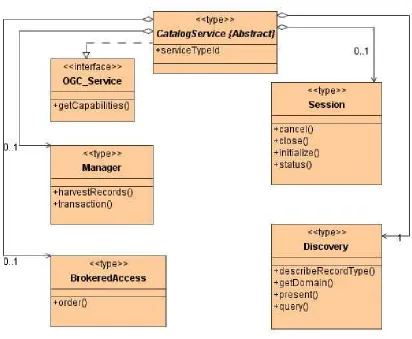
7 General catalogue interface model...25
7.1 Introduction...25
7.2 Interface definitions ...26
7.2.1 Overview...26
7.2.2 Catalogue Service class...29
7.2.7 Brokered Access class...56
7.3 Protocol, interface and operation specializations...58
7.4 Dynamic model...58
7.4.1 Introduction...58
7.4.2 UML state diagram notation ...59
7.4.3 Catalogue server state machine...59
7.4.4 Discovery state...60
7.4.5 Access state diagram...62
7.4.6 Management state ...65
7.4.7 Explain state diagram...65
8 Z39.50 protocol binding...66
8.1 Architecture...66
8.1.1 Introduction...66
8.1.2 Supported services ...67
8.1.3 Core queryable elements...67
8.2 General model to Z39.50 protocol binding operations mapping ...67
8.3 Z39.50 BER implementation notes...69
8.3.1 Message encoding...70
8.3.2 Additional search info...70
8.3.3 Order extended service ...71
8.4 Search/Retrieve Web Service (SRW/SRU) implementation notes...83
9 CORBA/IIOP protocol binding ...85
9.1 Architecture...85
9.1.1 Supported services ...85
9.1.2 Core queryable elements...85
9.2 Content types (Catalogue entry types)...85
9.3 Supported query languages ...85
9.4 Result set encodings...86
9.4.1 XML...86
9.4.2 Name-Value pairs ...86
9.5 General model to CORBA protocol binding operations mapping...87
9.6 Interface definition - IDL...88
9.6.1 Introduction...88
9.6.2 Enumerations ...89
9.6.3 Structures and unions...89
9.6.4 Definitions for brokered access ...92
9.6.5 Capabilities ...93
9.6.6 General messages...94
9.6.7 Discovery messages ...96
9.6.8 Management messages...98
9.6.9 Access messages ...99
9.6.10 Exceptions...100
9.6.11 Catalogue Service interfaces...101
9.6.12 Basic interfaces ...102
9.6.13 Complete IDL ...103
10.2 The HTTP protocol ...115
10.2.1 Overview...115
10.2.2 Message headers ...116
10.2.3 Content encoding ...117
10.2.4 Request methods ...117
10.2.5 Message payload...118
10.3 Operation request and response encoding...123
10.3.1 Introduction...123
10.3.2 SOAP ...123
10.3.3 Namespaces...125
10.3.4 Predicate languages...126
10.3.5 General model message mapping ...127
10.3.6 Common request parameters...128
10.3.7 Exception reporting...129
10.4 Operations overview ...129
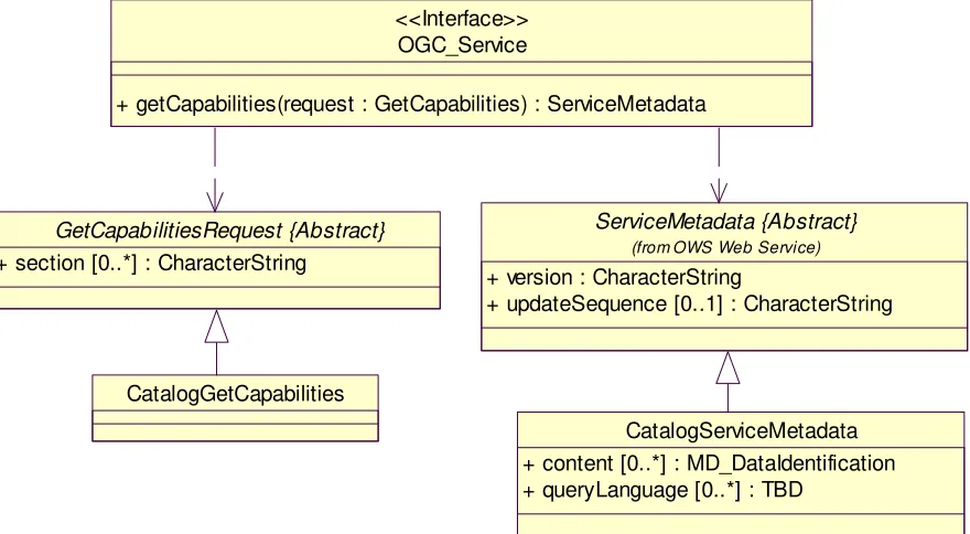
10.5 GetCapabilities operation...131
10.5.1 Introduction...131
10.5.2 Operation request ...131
10.5.3 Operation response...132
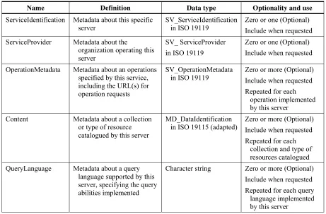
10.5.4 OperationsMetadata section standard contents...132
10.5.5 Examples...134
10.6 DescribeRecord operation...134
10.6.1 Introduction...134
10.6.2 KVP encoding...135
10.6.3 XML encoding ...135
10.6.4 Parameter descriptions ...136
10.6.5 Response ...137
10.6.6 Examples...138
10.7 GetDomain operation...138
10.7.1 Introduction...138
10.7.2 KVP encoding...138
10.7.3 XML encoding ...139
10.7.4 Parameter descriptions ...140
10.7.5 Response ...140
10.7.6 Examples...141
10.8 GetRecords operation...142
10.8.1 Introduction...142
10.8.2 KVP encoding...142
10.8.3 XML encoding ...145
10.8.4 Parameter descriptions ...147
10.8.5 Response ...157
10.8.6 Examples...159
10.9 GetRecordById operation ...160
10.9.1 Introduction...160
10.9.6 Examples...164
10.10 Record locking ...165
10.11 Transaction operation...165
10.11.1 Introduction...165
10.11.2 KVP encoding...165
10.11.3 XML encoding ...166
10.11.4 Response ...168
10.12 Harvest operation ...169
10.12.1 Introduction...169
10.12.2 KVP encoding...170
10.12.3 XML encoding ...172
10.12.4 Parameter descriptions ...172
10.12.5 Response ...174
10.12.6 Examples...175
10.13 XML Schemas ...175
11 Specializing general model through protocol bindings and profiles ...176
11.1 Introduction...176
11.2 Interface definitions ...177
11.3 Query model components ...178
11.3.1 Query language/model ...178
11.3.2 Common search and retrieval elements ...178
11.4 Catalogue Application Profiles ...179
11.5 Structure and format ...181
11.5.1 Introduction...181
11.5.2 System context ...182
11.5.3 Information models...182
11.5.4 External interfaces ...183
11.6 Compliance ...184
Annex A (normative) Abstract conformance test suite...185
Annex B (informative) Description of Distributed Search ...186
Annex C (informative) Details of order operation...189
C.1 Introduction...189
C.2 BrokeredAccessRequest ...189
C.3 BrokeredAccessResponse ...190
C.4 Parameter Type Definitions ...192
Annex D (informative) Sample CSW capabilities document ...198
Annex E (Normative) Minimum XPath subset...203
Figures
PageFigure 1 — UML notations...8
Figure 2 — Information discovery continuum ...9
Figure 3 — Reference model architecture ...26
Figure 4 — General OGC catalogue UML static model ...27
Figure 5 — getCapabilities operation UML static model...30
Figure 6 — “query” operation UML static model ...33
Figure 7 — “present” operation UML static model...38
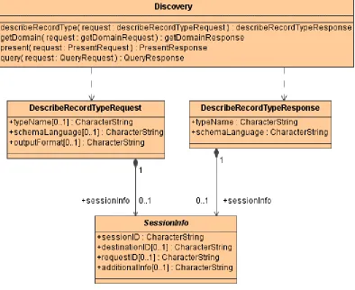
Figure 8 — describeRecordType operation UML static model...41
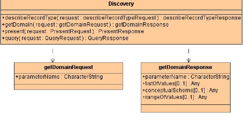
Figure 9 — getDomain operation UML static model...43
Figure 10 — “initialize” operation UML static model ...45
Figure 11 — “close” operation UML static model ...46
Figure 12 — “status” operation UML static model ...48
Figure 13 — “cancel” operation UML static model...50
Figure 14 — “transaction” operation UML static model...52
Figure 15 — harvestResource operation UML static model ...54
Figure 16 — “order” operation UML static model...57
Figure 17 — UML state diagram notation...59
Figure 18 — Catalogue session state diagram...60
Figure 19 — Discovery state diagram (without Status and Cancel)...61
Figure 20 — Discovery state diagram (complete)...62
Figure 21 — Access state diagram ...63
Figure 22 — Order estimation state diagram...64
Figure 23 — Order submit state diagram ...64
Figure 24 — Management state diagram...65
Figure 25 — Explain state diagram ...66
Figure 26 — Z39.50 Protocol binding Sequence Diagram...69
Figure 27 — Name-value pair results...87
Figure 31 — Relationship of general model, protocol binding, and application profile .177
Figure 32 — Application profiles specify concrete catalogue services...179
Figure 33 — Relationships between base specs, profiles, and implementations...180
Figure B.1 — Query network topology resulting in duplicates...187
Figure B.2 — Query network topology resulting in a loop ...187
Tables
Page Table 1 — Common queryable elements...20Table 2 — Composition of compound element “BoundingBox” ...20
Table 3 — Composition of compound element “Association” ...21
Table 4 — List of common returnable properties...22
Table 5 — Attribute of Catalogue Service class...29
Table 6 — Definition of getCapabilities operation...29
Table 7 — UML attribute in getCapabilities operation request ...30
Table 8 — UML attributes in getCapabilities operation normal response ...31
Table 9 — Definition of “query” operation...32
Table 10 — UML attributes and roles in “query” operation request...34
Table 11 — UML attributes in SortSpec data type...36
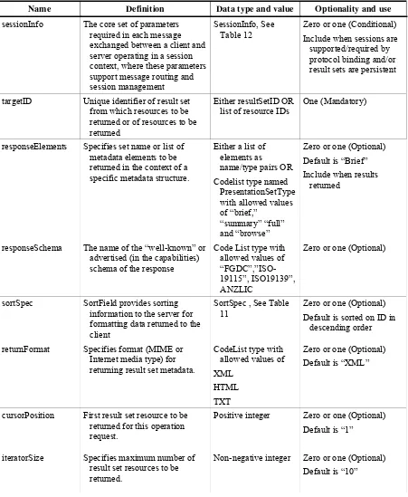
Table 12 — UML attributes in SessionInfo data type ...36
Table 13 — UML attributes in QueryExpression data type ...36
Table 14 — UML attributes and role “query” operation normal response...37
Table 15 — Definition of “present” operation ...38
Table 16 — UML attributes and role in “present” operation request...39
Table 17 — UML attributes and role in “present” operation normal response ...40
Table 18 — Definition of describeRecordType operation ...40
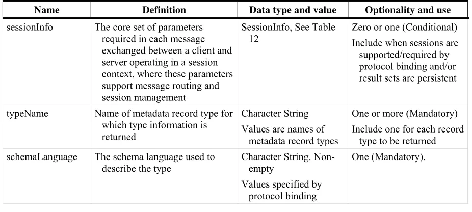
Table 19 — UML attributes and role in describeRecordType operation request...41
Table 20 — UML attributes and role in describeRecordType operation normal response42 Table 21 — Definition of getValueDomain operation ...42
Table 22 — UML attribute in getDomain operation request...43
Table 23 — UML attributes and role in getValueDomain operation normal response...43
Table 24 — Definition of “initiaize” operation ...44
Table 26 — UML role name in “initiaize” operation normal response...45
Table 27 — Definition of “close” operation...46
Table 28 — UML role name in “close” operation request ...46
Table 29 — UML role name in “close” operation normal response ...47
Table 30 — Definition of “status” operation...47
Table 31 — UML attribute and role in “status” operation request...48
Table 32 — UML attribute and role in “status” operation normal response ...49
Table 33 — Definition of “cancel” operation...49
Table 34 — UML attributes and role in “cancel” operation request ...50
Table 35 — UML attributes and role in “cancel” operation normal response ...51
Table 36 — Definition of “transaction” operation ...52
Table 37 — UML attributes in “transaction” operation request...53
Table 38 — UML attributes in “transaction” operation normal response ...53
Table 39 — harvestResource operation...54
Table 40 — UML attributes in harvestResource operation request ...55
Table 41 — UML attributes in harvestResource operation normal response...55
Table 42 — Definition of “order” operation...56
Table 43 — UML attributes in “order” operation request ...57
Table 44 — UML attributes in “order” operation normal response ...58
Table 45 — Correspondence of Z39.50 Attributes to general model equivalents...67
Table 46 — General Model to Z39.50 protocol binding operations mapping and obligation...68
Table 47 — Order extended service ...72
Table 48 — SearchRetrieve request parameters ...84
Table 49 — SearchRetrieve response parameters ...84
Table 50 — General Model to CORBA protocol binding operations mapping and obligation...88
Table 51 — HTTP message elements...116
Table 52 — Selected HTTP Request Methods ...117
Table 53 — Mapping of Dublin Core names to XML element names...119
Table 54 — HTTP method bindings...123
Table 58 — Additional section name value and meaning ...132
Table 59 — Section names and contents ...132
Table 60 — Required values of the OperationsMetadata section attributes...133
Table 61 — Optional values of the OperationsMetadata section attributes ...133
Table 62 — KVP encoding for DescribeRecord operation request...135
Table 63 — KVP encoding for GetDomain operation request...139
Table 64 — Interface parameters that may be interrogated using GetDomain operation140 Table 65 — KVP encoding for GetRecords operation request...143
Table 66 — <SearchResults> Parameters ...159
Table 67 — KVP encoding for GetRecordById operation request ...161
Table 68 — KVP encoding for Harvest operation request ...171
Table 69 — URIs for well known metadata standards ...173
Table 70 — Structure of an application profile ...181
Table 71 — System context: required subclauses ...182
Table 72 — Information models: required subclauses ...183
Table 73 — Public interfaces: required subclauses ...183
Table C.1 — Brokered Access Request Types...193
i.
Preface
This document explains how Catalogue Services version 2.0 are organised and
implemented for the discovery and retrieval of spatial data and services metadata. The prior public version of this specification was 1.1.1. Catalogue Services version 2.0 supersedes and deprecates version 1.1.1.
This revision of this document has been significantly improved, largely based on the comments on document 04-021 received by the Revision Working Group. The changes made in this second corrigendum are summarized in the Corrigendum description document [OGC 07-010].
ii.
Submitting organizations
The following organizations submitted the original document or its revisions to the Open GIS Consortium, Inc. in response to the OGC Request 6, Core Task Force, Catalogue Working Group, A Request for Proposals: OpenGIS® Catalogue Interface (OpenGIS® Project Document Number 98-001r2):
BAE SYSTEMS Mission Solutions (formerly Marconi Integrated Systems, Inc.) Blue Angel Technologies, Inc.
Environmental Systems Research Institute (ESRI)
Geomatics Canada (Canada Centre for Remote Sensing (CCRS) Intergraph Corporation
MITRE
Oracle Corporation
U.S. Federal Geographic Data Committee (FGDC)
U.S. National Aeronautics and Space Administration (NASA) U.S. National Imagery and Mapping Agency (NIMA)
Contributing Entities
The submitting entities were grateful for the contributions from the following companies in the development and revision of this Interface Specification:
GEODAN IT bv
Hammon, Jensen, Wallen & Associates, Inc (HJW) Ionic Software, sa
JRC (Joint Research Centre), European Commission SICAD GEOMATICS
Traverse Technologies
iii.
Document contributor contact points
All questions regarding this document should be directed to the editor or the contributors: Name Organization
Doug Nebert U.S. Federal Geographic Data Committee Arliss Whiteside BAE SYSTEMS Mission Solutions Panagiotis (Peter) Vretanos CubeWerx, Inc.
Louis Reich NASA (Computer Sciences Corp) Richard Martell Galdos Systems Inc.
Uwe Voges con terra GmbH
iv.
Revision history
Date Release Editor Primary clauses modified Description
12Aug1999 1.0 Nebert N/A Original Specification entitled “Catalogue Interface Implementation Specification” OGC Document 00-034 28Mar2001 1.1 Nebert Made fine-grain CORBA
and OLE/COM Annexes to Informative, added abstract conformance test suite, fixed coarse-grain CORBA IDL
Document only made available to OGC membership pending passage of Version 2.0. (OGC Document 01-040)
11Nov2002 1.1.1 Nebert, Katz,
State diagram changes, renamed specification and changed WWW Profile to Z39.50 Profile, added introductory words as required for new format
Document primarily reflects conversion to newer OGC/ISO document format
22Dec2003 2.0.0 Nebert All Reorganised and largely rewrote document.
14Apr2004 2.0.0 Whiteside All
11May2004 2.0.0 Nebert Merge updates on Clauses 1-5, 6-8, 9, 10, and 11 from separate editors
Responded to all RWG review comments.
v.
Changes to the OGC Abstract Specification
The OpenGIS® Abstract Specification requires minor changes to accommodate the technical contents of this document to reflect the use of catalogue services to search for and retrieve any type of information object (data, service instance, service type, schema, style description, etc.) based on its properties described in “metadata.”
vi.
Future work
Foreword
This version deprecates and replaces Catalogue Service Specification 1.1.1 (OGC Document 02-087r3).
This document, through its implementation profiles, references several external standards and specifications as dependencies:
a) Common Object Request Broker Architecture (CORBA/IIOP), Version 2.X, The Object Management Group (OMG): http://www.omg.org
b) Information and documentation -- Information retrieval (Z39.50) -- Application service definition and protocol specification:
http://www.iso.ch/iso/en/CatalogDetailPage.CatalogDetail?CSNUMBER=27446&IC S1=35&ICS2=240&ICS3=30
c) ISO/IEC TR 10000-1:1998. Information Technology – Framework and taxonomy of International Standardised Profiles – Part 1: General principles and documentation framework. Technical Report, JTC 1. Fourth edition. Available [online]:
<http://standards.iso.org/ittf/PubliclyAvailableStandards/c030726_ISO_IEC_TR_100 00-1_1998(E).zip>.
d) ISO/IEC 10746-2:1996. Information Technology – Open Distributed Processing – Reference Model: Foundations. Common text with ITU-T Recommendation X.902. Available [online]:
< http://standards.iso.org/ittf/PubliclyAvailableStandards/s018836_ISO_IEC_10746-2_1996(E).zip >.
e) Unified Modeling Language (UML) Version 1.3, The Object Management Group (OMG): http://www.omg.org/cgi-bin/doc?formal/00-03-01
f) The Extensible Markup Language (XML), World Wide Web Consortium,
http://www.w3.org/TR/1998/REC-xml-19980210
Annex A, the Abstract Conformance Test Suite, is normative to this specification and shall be implemented when a computing environment requires catalogue services. All other annexes are informative and provide background information, such as terminology and alternative implementation approaches.
Introduction
This document specifies the interfaces between clients and catalogue services, through the presentation of abstract and implementation-specific models. Catalogue services support the ability to publish and search collections of descriptive information (metadata) for data, services, and related information objects. Metadata in catalogues represent resource characteristics that can be queried and presented for evaluation and further processing by both humans and software. Catalogue services are required to support the discovery and binding to registered information resources within an information
OpenGIS® Catalogue Services Specification
1 Scope
This OGC™ document specifies the interfaces, bindings, and a framework for defining application profiles required to publish and access digital catalogues of metadata for geospatial data, services, and related resource information. Metadata act as generalised properties that can be queried and returned through catalogue services for resource evaluation and, in many cases, invocation or retrieval of the referenced resource. Catalogue services support the use of one of several identified query languages to find and return results using well-known content models (metadata schemas) and encodings. This OpenGIS® document is applicable to the implementation of interfaces on catalogues of a variety of information resources.
The target audience for this specification is the community of software developers who are:
a) Implementers of OGC compliant Catalogue servers b) Implementers of OGC compliant Catalogue clients
2 Conformance
Abstract conformance to the mandatory catalogue service interfaces is described in Annex A. In a given community, a test suite should include test metadata records with a variety of element values and a series of queries that would return correct and properly formatted results. Test data and queries may be included in associated Application Profiles.
3 Normative references
The following normative documents contain provisions that, through reference in this text, constitute provisions of this part of OGC 03-108. For dated references, subsequent amendments to, or revisions of, any of these publications do not apply. For undated references, the latest edition of the normative document referred to applies.
ANSI/NISO Z39.50-2003, Information Retrieval (Z39.50): Application Service Definition and Protocol Specification (revision of Z39.50-1995)
IETF RFC 2045 (November 1996), Multipurpose Internet Mail Extensions (MIME) Part One: Format of Internet Message Bodies, Freed, N. and Borenstein N., eds.,
http://www.ietf.org/rfc/rfc2045.txt
IETF RFC 2141 (May 1997), URN Syntax, R. Moats, http://www.ietf.org/rfc/rfc2141.txt IETF RFC 2396 (August 1998), Uniform Resource Identifiers (URI): Generic Syntax, Berners-Lee, T., Fielding, N., and Masinter, L., eds., http://www.ietf.org/rfc/rfc2396.txt IETF RFC 2616 (June 1999), Hypertext Transfer Protocol – HTTP/1.1, Gettys, J., Mogul, J., Frystyk, H., Masinter, L., Leach, P., and Berners-Lee, T., eds.,
http://www.ietf.org/rfc/rfc2616.txt
IANA, Internet Assigned Numbers Authority, MIME Media Types, available at
http://www.iana.org/assignments/media-types/
CORBA/IIOP, Common Object Request Broker Architecture, Version 2.X, The Object Management Group (OMG): http://www.omg.org
ISO/IEC TR 10000-1:1998. Information Technology – Framework and taxonomy of International Standardised Profiles – Part 1: General principles and documentation framework. Technical Report, JTC 1. Fourth edition, Available [online]:
< http://standards.iso.org/ittf/PubliclyAvailableStandards/c030726_ISO_IEC_TR_10000-1_1998(E).zip>.
ISO/IEC 10746-2:1996. Information Technology – Open Distributed Processing – Reference Model: Foundations. Common text with ITU-T Recommendation X.902, Available [online]:
< http://standards.iso.org/ittf/PubliclyAvailableStandards/s018836_ISO_IEC_10746-2_1996(E).zip >.
ISO 4217:2001, Codes for the representation of currencies and funds
ISO 8601:2000(E), Data elements and interchange formats - Information interchange - Representation of dates and times
ISO 11180, Postal addressing
ISO/IEC 14977:1996, Information technology – Syntactic metalanguage – BNF ISO 19106:2003, Geographic Information – Profiles
ISO 19115:2003, Geographic Information – Metadata ISO/DIS 19119, Geographic Information – Services
OGC 99-054, OpenGIS® Simple Features Specification for CORBA OGC 99-113, OGC Abstract Specification Topic 13: Catalogue Services
OGC 02-112, OGC Abstract Specification Topic 12: OpenGIS Service Architecture OGC 04-095, Filter Encoding Implementation Specification
OGC 05-008c1, OWS Common Implementation Specification
NOTE This OWS Common Implementation Specification contains a list of normative references that are also
applicable to this Implementation Specification.
OMG UML, Unified Modeling Language, Version 1.3, The Object Management Group (OMG): http://www.omg.org/cgi-bin/doc?formal/00-03-01
W3C Recommendation January 1999, Namespaces In XML,
http://www.w3.org/TR/2000/REC-xml-names
W3C Recommendation 6 October 2000, Extensible Markup Language (XML) 1.0 (Second Edition), http://www.w3.org/TR/REC-xml
W3C Recommendation 2 May 2001: XML Schema Part 0: Primer,
http://www.w3.org/TR/2001/REC-xmlschema-0-20010502/
W3C Recommendation 2 May 2001: XML Schema Part 1: Structures,
http://www.w3.org/TR/2001/REC-xmlschema-1-20010502/
W3C Recommendation 2 May 2001: XML Schema Part 2: Datatypes,
http://www.w3.org/TR/2001/REC-xmlschema-2-20010502/
W3C Recommendation (24 June 2003): SOAP Version 1.2 Part 1: Messaging Framework, http://www.w3.org/TR/SOAP/
W3C Recommendation (16 November 1999): XML Path Language (XPath) Version 1.0,
http://www.w3.org/TR/xpath.html
In addition to this document, this specification includes several normative XML Schema files. These are posted online at the URL http://schemas.opengis.net/. These XML Schema files are also bundled with this document. In the event of a discrepancy between the bundled and online versions of the XML Schema files, the online files shall be considered authoritative.
4 Terms and definitions
4.1 client
software component that can invoke an operation from a server 4.2
data clearinghouse
collection of institutions providing digital data, which can be searched through a single interface using a common metadata standard [ISO 19115]
4.3 data level
stratum within a set of layered levels in which data is recorded that conforms to definitions of types found at the application model level [ISO 19101]
4.4 dataset series
collection of datasets sharing the same product specification [ISO 19113, ISO 19114, ISO 19115]
4.5
feature catalogue
catalogue containing definitions and descriptions of the feature types, feature attributes, and feature relationships occurring in one or more sets of geographic data, together with any feature operations that may be applied [ISO 19101, ISO 19110]
4.6
geographic dataset
dataset with a spatial aspect [ISO 19115] 4.7
geographic information
information concerning phenomena implicitly or explicitly associated with a location relative to the Earth [ISO 19128 draft]
4.8 identifier
a character string that may be composed of numbers and characters that is exchanged between the client and the server with respect to a specific identity of a resource 4.9
interface
named set of operations that characterize the behaviour of an entity [ISO 19119] 4.10
metadata dataset
4.11 metadata entity
group of metadata elements and other metadata entities describing the same aspect of data
NOTE 1 A metadata entity may contain one or more metadata entities.
NOTE 2 A metadata entity is equivalent to a class in UML terminology [ISO 19115].
4.12
metadata schema
conceptual schema describing metadata
NOTE ISO 19115 describes a standard for a metadata schema. [ISO 19101]
4.13
metadata section
subset of metadata that defines a collection of related metadata entities and elements [ISO 19115]
4.14 operation
specification of a transformation or query that an object may be called to execute [ISO 19119]
4.15 parameter
variable whose name and value are included in an operation request or response 4.16
profile
set of one or more base standards and - where applicable - the identification of chosen clauses, classes, subsets, options and parameters of those base standards that are necessary for accomplishing a particular function [ISO 19101, ISO 19106] 4.17
qualified name
name that is prefixed with its naming context
EXAMPLE The qualified name for the road no attribute in class Road defined in the Roadmap schema is
RoadMap.Road.road_no. [ISO 19118]
4.18
reporting group
data with common characteristics forming a subset of a dataset
NOTE 1 Common characteristics can include belonging to an identified feature type, feature attribute or feature
relationship; sharing data collection criteria; sharing original source; or being within a specified geographic or temporal extent.
4.19 request
invocation of an operation by a client 4.20
response
result of an operation, returned from a server to a client 4.21
resource
an object or artefact that is described by a record in the information model of a catalogue 4.22
schema
formal description of a model [ISO 19101, ISO 19103, ISO 19109, ISO 19118] 4.23
server
service instance
a particular instance of a service [ISO 19119 edited] 4.24
service
distinct part of the functionality that is provided by an entity through interfaces [ISO 19119]
capability which a service provider entity makes available to a service user entity at the interface between those entities [ISO 19104 terms repository]
4.25
service interface
shared boundary between an automated system or human being and another automated system or human being [ISO 19101]
4.26
service metadata
metadata describing the operations and geographic information available at a server [ISO 19128 draft]
4.27 state
condition that persists for aperiod
NOTE The value of a particular feature attribute describes a condition of the feature [ISO 19108].
4.28
4.29 version
version of an Implementation Specification (document) and XML Schemas to which the requested operation conforms
NOTE An OWS Implementation Specification version may specify XML Schemas against which an XML
encoded operation request or response shall conform and should be validated.
5 Conventions
5.1 Symbols (and abbreviated terms)
Some frequently used abbreviated terms:
CORBA Common Object Request Broker Architecture DCP Distributed Computing Platform
HTTP Hypertext Transfer Protocol IDL Interface Definition Language
ISO International Organization for Standardization KVP Keyword Value Pair
MIME Multipurpose Internet Mail Extensions
OGC Open GIS Consortium, also referred to as OpenGIS® TBD To Be Determined
TBR To Be Reviewed
UML Unified Modeling Language XML Extensible Markup Language
Z39.50 Service definition for information search and retrieval, also known as ISO 23950
5.2 UML notation
Some of the diagrams in this document are presented using the Unified Modeling
A ssociation betw een classes
A ggregation betw een classes
Aggregate
Class Inheritance (subtyping of classes)
Superc las s
Subc lass #1
… … … … ..
Subc las s #2 Subc las s #n
Figure 1 — UML notations
In these UML class diagrams, the class boxes with a light background are the primary classes being shown in this diagram, often the classes from one UML package. The class boxes with a gray background are other classes used by these primary classes, usually classes from other packages.
In this diagram, the following stereotypes of UML classes are used:
a) <<Interface>> A definition of a set of operations that is supported by objects having this interface. An Interface class cannot contain any attributes.
b) <<Type>> A stereotyped class used for specification of a domain of instances (objects), together with the operations applicable to the objects. A Type class may have attributes and associations.
c) <<DataType>> A descriptor of a set of values that lack identity (independent
existence and the possibility of side effects). A DataType is a class with no operations whose primary purpose is to hold the information.
d) <<CodeList>> A flexible enumeration that uses string values for expressing a list of potential values. If the list alternatives are completely known, an enumeration shall be used; if the only likely alternatives are known, a code list shall be used.
In this document, the following standard data types are used: a) CharacterString – A sequence of characters
b) Boolean – A value specifying TRUE or FALSE c) Integer – An integer number
d) Identifier – Unique identifier of an object
e) URI – An identifier of a resource that provides more information
f) URL – An identifier of an on-line resource that can be electronically accessed
5.3 Document terms and definitions
This document uses the specification terms defined in Subclause 5.3 of [OGC 05-008c1].
6 Catalogue abstract information model
6.1 Introduction
The abstract information model specifies a BNF grammar for a minimal query language, a set of core queryable attributes (names, definitions, conceptual datatypes), and a
common record format that defines the minimal set of elements that should be returned in the brief and summary element sets.
The geospatial community is a very broad-based community that works in many different operational environments, as shown in the information discovery continuum in Figure 2. On one extreme there are tightly coupled systems dedicated to well defined functions in a tightly controlled environment. At the other extreme are Web based services that know nothing about the client. This document provides a specification that is applicable to the full range of catalogue operating environments.
SimpleFeatures
Domain knowledge
Global Information Discovery
Information Exploitation Google GEO CIP DCS
Heterogeneous Homogeneous
high low
Architectures Application scope
6.2 Query language support
6.2.1 Introduction
The query capabilities of the OGC General Catalogue Model provide a minimum set of data types and query operations that can be assumed of OGC Compliant Catalogue implementations. In addition, these Query Capabilities provide a high degree of
flexibility enabling alternate styles of query, result presentation, and the potential support of any geo-enabled query language. This flexibility is provided by the query operation that contains the parameters needed to select the query result presentation style and to provide a query expression which includes the actual query with an identification of the query language used. The query operation, query expression, and other related operations are further discussed in Clause 7.2.4.
The interoperability goal is supported by the specification of a minimal abstract query (predicate) language, which shall be supported by all compliant OpenGIS Catalogue Services. This query language supports nested Boolean queries, text matching operations, temporal data types, and geospatial operators. The minimal query language syntax is based on the SQL WHERE clause in the SQL SELECT statement. Implementations of query languages that are transformable to the OGC_Common Catalogue Query Language are the OGC Filter Specification and the CIP and GEO profiles of Z39.50 Type-1 queries. The minimal query language assists the consumer in the discovery of datasets of interest at all sites supporting the OpenGIS Catalogue Services. The ability to specify alternative query languages allows for evolution and higher levels of interoperability among more tightly coupled communities of Catalogue Service Providers and Consumers.
6.2.2 OGC_Common catalogue query language
This subclause defines the BNF for the OGC_Common Catalogue Query Language. OGC_Common is the query language to be supported by all OGC Catalogue Interfaces in order to support search interoperability.
Assumptions made during the development of OGC_Common Query Language: a) The query will have a syntax similar to the SQL “Where Clause.”
b) The expressiveness of the query will not require extensions to various current query systems used in geospatial catalogue queries other than the implementation of some geo operators.
c) The query language is extensible.
d) OGC_Common supports both tight and loose queries. A tight query is defined where if a catalogue doesn’t support an attribute/column specified in the query, no
BNF definition of OGC_Common Query Language:
<SQL terminal character> ::= <SQL language character> <SQL language character> ::= <simple Latin letter> | <digit>
| <SQL special character>
<simple Latin letter> ::= <simple Latin upper case letter> | <simple Latin lower case letter> <simple Latin upper case letter> ::=
A | B | C | D | E | F | G | H | I | J | K | L | M | N | O | P | Q | R | S | T | U | V | W | X | Y | Z
<simple Latin lower case letter> ::=
a | b | c | d | e | f | g | h | i | j | k | l | m | n | o | p | q | r | s | t | u | v | w | x | y | z
<digit> ::=
0 | 1 | 2 | 3 | 4 | 5 | 6 | 7 | 8 | 9 <SQL special character> ::= <space>
| <double quote>
<space> ::= /*space character in character set in use In ASCII it would be 40*/
<colon> ::= : <semicolon> ::= ;
<less than operator> ::= < <equals operator> ::= =
<greater than operator> ::= > <question mark> ::= ?
<left bracket> ::= [ <right bracket> ::= ] <circumflex> ::= ^ <underscore> ::= _ <vertical bar> ::= | <left brace> ::={ <right brace> ::=}
<separator> ::= { <comment> | <space> | <newline> }
/* The next section of the BNF defines the tokens available to the language. I have deleted the concepts of bit string, hex string and national character string literal. Keywords have been added to support the geo literals. */
<token> ::= <nondelimiter token> | <delimiter token>
<nondelimiter token> ::= <regular identifier> | <key word>
| <unsigned numeric literal> <regular identifier> ::= <identifier body>
<identifier body> ::=
<identifier start> [ { <underscore> | <identifier part> } ] <identifier start> ::= <simple latin letter>
<identifier part> ::= <identifier start> | <digit>
<key word> ::= <reserved word>
<reserved word> ::= AND | POINT | LINESTRING | POLYGON | MULTIPOINT | MULTILINESTRING | MULTIPOLYGON | EMPTY | DATE | TIME | TIMESTAMP | FALSE| TRUE | UNKNOWN | LIKE | MINUTE | MONTH | NOT | NULL
<unsigned numeric literal> ::= <exact numeric literal>
| <approximate numeric literal> <exact numeric literal> ::= <unsigned integer>
[<period>[<unsigned integer>]] |<period> <unsigned integer> <unsigned integer> ::= {<digit>}
<approximate numeric literal> ::= <mantissa> E <exponent> <mantissa> ::= <exact numeric literal>
<exponent> ::= <signed integer>
<signed integer> ::= [ <sign> ] <unsigned integer> <sign> ::= <plus sign> | <minus sign>
<character string literal> ::=
<quote> [ {<character representation>} ] <quote>
<character representation> ::= <nonquote character> | <quote symbol> <quote symbol> ::= <quote><quote>
/*End of non delimiter tokens*/
| <not equals operator> <character string literal> ::=
<quote> [ {<character representation>} ] <quote>
<character representation> ::= <nonquote character> | <quote symbol> <quote symbol> ::= <quote><quote>
<not equals operator> ::= <>
<greater than or equals operator> ::= >= <less than or equals operator> ::= <=
/*The following section is intended to give context for identifier and namespaces. It assumes that the default namespace is specified in the query request and does not allow any overrides of the namepace */ <identifier> ::=
<identifier start [ { <colon> | <identifier part> } ] <identifier start> ::= <simple Latin letter>
<identifier part> ::= <simple Latin letter> | <digit>
<attribute name> ::= <simple attribute name> | <compound attribute name>
<simple attribute name> ::= <identifier>
<compound attribute name> ::= <identifier><period> [{<identifier><period>}…] <simple attribute name>
/*The rest of the BNF is the real BNF for the query capabilities.*/ <search condition> ::= <boolean value expression>
<boolean value expression> ::= <boolean term>
| <boolean value expression> OR <boolean term> <boolean term> ::= <boolean factor>
| <boolean term> AND <boolean factor> <boolean factor> ::= [ NOT ] <boolean primary>
<boolean primary> ::= <predicate> |
<routine invocation> |
<left paren> <search condition> <right paren> <predicate> ::= <comparison predicate>
| <text predicate> | <null predicate> | <temporal predicate>
| <classification predicate> | <existence_predicate>
/* This set of productions define temporal predicates */
<temporal predicate> ::= <attribute_name> BEFORE <date-time expression> | <attribute_name> BEFORE OR DURING <period> | <attribute_name> DURING <period>
/* This set of productions enables loose or tight queries. For example the predicate “cloudcover EXISTS” evaluates as true for all record instances where the attribute cloudcover is a member of the record schema. Similarly, the predicate “cloudcover DOESNOTEXIST” evaluates as true for all record instances where the attribute cloudcover is not a member of the record schema.*/
<existence_predicate> := <attribute_name> EXISTS
| <attribute_name> DOES-NOT-EXIST
<comparison predicate> ::= <attribute name> <comp op> <literal>
<text predicate> ::= <attribute name> [ NOT ] LIKE <character pattern> <null predicate> ::= <attribute name> IS [ NOT ] NULL
<character pattern> ::= <character string literal>
/* In a character pattern the character percent is used as a wildcard to represent an arbitrary string. This allows LIKE to
implement the effect of many characters matching operations, such as: contains, begins with, ends with, not contains, not begins with, not ends with, and so forth. For example:
attribute like '%contains_this%' <comp op> ::= <equals operator>
| <not equals operator> | <less than operator> | <greater than operator>
| <less than or equals operator> | <greater than or equals operator> <literal> ::= <signed numeric literal>
| <general literal>
<signed numeric literal> ::= [<sign>] <unsigned numeric literal> <general literal> ::= <character string literal>
| <datetime literal> | <boolean literal> | <geography literal <boolean literal> ::= TRUE
| FALSE | UNKNOWN
<routine invocation> ::= | <geoop name><georoutine argument list> | <relgeoop name><relgeoop argument list> | <routine name><argument list>
<routine name> ::= < attribute name>
<geoop name> ::= EQUALS | DISJOINT | INTERSECTS | TOUCHES | CROSSES | WITHIN | CONTAINS | OVERLAPS | RELATE
<relgeoop name> ::= DWITHIN | BEYOND <argument list> ::=
<relgeoop argument list> ::= <left paren>
<attribute name><comma><geometry literal><comma><tolerance> <right paren>
<tolerance> ::= <unsigned numeric literal><comma><distance units> <distance units> ::= = “feet” | “meters” | “statute miles” | “nautical miles” | “kilometers”
/*this set of units is just an example. The real list of distance unit must be developed*/
<geometry literal> := <Point Tagged Text> | <LineString Tagged Text>
<Point Tagged Text> := POINT <Point Text>
<LineString Tagged Text> := LINESTRING <LineString Text> <Polygon Tagged Text> := POLYGON <Polygon Text>
<MultiPoint Tagged Text> := MULTIPOINT <Multipoint Text>
<MultiLineString Tagged Text> := MULTILINESTRING <MultiLineString Text> <MultiPolygon Tagged Text> := MULTIPOLYGON <MultiPolygon Text>
<GeometryCollection Tagged Text> :=
GEOMETRYCOLLECTION <GeometryCollection Text>
<Point Text> := EMPTY | <left paren> <Point> <right paren> <Point> := <x><space><y>
<x> := numeric literal <y> := numeric literal <LineString Text> := EMPTY
| <left paren> <Point>
{<comma><Point >} <right paren> <Polygon Text> := EMPTY
| <left paren> <LineString Text>
{<comma><LineString Text>} <right paren>
<Multipoint Text> := EMPTY
| <left paren> <Point Text>
{<comma><Point Text >} <right paren>
<MultiLineString Text> := EMPTY
| <left paren> <LineString Text>
{<comma><LineString Text>} <right paren>
<MultiPolygon Text> := EMPTY
| <left paren> <Polygon Text>
{<comma><Polygon Text>} <right paren>
<GeometryCollection Text> := EMPTY
{<comma><geometry literal>} <right paren>
<Envelope Tagged Text> ::= ENVELOPE <Envelope Text> <Envelope Text> := EMPTY
| <left paren>
<WestBoundLongitude><comma> <EastBoundLongitude><comma> <NorthBoundLatitude><comma> <SouthBoundLatitude>
<right paren>
<WestBoundLongitude> := <signed numeric literal> <EastBoundLongitude> := <signed numeric literal> <NorthBoundLatitude> := <signed numeric literal> <SouthBoundLatitude> := <signed numeric literal>
<date-time> ::= <full-date> "T" <UTC-time>
<full_date> ::= <date-year> "-" <date-month> "-" <date-day> <date-year> ::= <digit><digit><digit><digit>
<date-month> ::= <digit><digit> <date-day> ::= <digit><digit>
<UTC-time> ::= <time-hour> ":" <time-minute> ":" <time-second> "Z" <time-hour> ::= <digit><digit>
<time-minute> ::= <digit><digit>
<time-second> ::= <digit><digit>[.{<digit>}]
<duration> ::= "P" (<dur-date> | <dur-time>)
<dur-date> ::= <dur-day> | <dur-month> | <dur-year> [<dur-time>] <dur-day> ::= {<digit>} "D"
<dur-month> ::= {<digit>} "M" [<dur-day>] <dur-year> ::= {<digit>} "Y" [<dur-month>]
<dur-time> ::= "T" (<dir-hour> | <dur-minute> | <dur-second>) <dur-hour> ::= {<digit>} "H" [<dur-minute>]
<dur-minute> ::= {<digit>} "M" [<dur-second>] <dur-second> ::= {<digit>} "S"
<period> ::= <date-time> "/" <date-time> | <date-time> "/" <duration> | <duration> "/" <date-time>
6.2.3 Extending the Common Catalogue Query Language
The Common Catalogue Query Language BNF can be extended by adding new predicates, operations, and datatypes. The following discussion is an example of
extending the BNF to include a CLASSIFIED-AS operator using the patterns identified in OASIS/ebXML Registry Services Specification v2.5. This extension could appear in a protocol binding or an Application Profile.
The CLASSIFIED-AS routine takes three arguments. The first argument is the abstract entry point whose classification is being checked. The second argument is the key name string that represents a path expression in the taxonomy. The last argument is the key value string that represents the corresponding path expression containing key values that are the targets of the query. In both cases, the first element of the path expression for the key name argument and key value arguments shall be the name of the taxonomy being used. The normal wildcard matching characters, ‘_’ for a single character and ‘%’ for zero or more characters, may be used in the key value expression which is the last argument of the CLASSIFIED_AS routine.
The following set of productions defines the CLASSIFIED-AS routine.
/* The following example: */ /* */ /* RECORD CLASSIFIED AS CLASSIFICATIONSCHEME=’GeoClass’ */
/* =’/GeoClass/North America/%/Ontario’ */
/* */ /* Will find all records in all the Ontario’s in North America. */
The following are the required BNF specializations:
<classop argument list> ::= <left paren> <entry_point> <comma> <Classification Scheme> <comma><Classification Node> <right paren>
<entry_point> ::= <identifier>
<Classification Scheme> ::= <identifier> <classop name> ::= CLASSIFIED_AS
<Classification Node> ::= <identifier> | <solidus><path element>[<solidus><path element>]…
<path element> ::= <character pattern>
<routine invocation> ::= | <geoop name><georoutine argument list> | <relgeoop name><relgeoop argument list> | <routine name><argument list>
| <classop><classop argument list>
Consider the following example:
CLASSIFIED_AS('RECORD', 'GeoClass', 'GeoClass/NorthAmerica/%/Ontario')
In this example, we are searching records classified according to the GeoClass taxonomy. Specifically, we are looking for all catalogue records classified as
Continent=NorthAmerica, Country=any country and State=Ontario. Notice how the wildcard character ‘%’ is used to search for any Country node.
Here is the same example encoded using XML:
<ogc:Filter xmlns:ogc="http://http://www.opengis.net/ogc"> <ogc:ClassifiedAs>
<ogc:ClassificationNode>/GeoClass/NorthAmerica/%/Ontario</ogc:Classific
ationNode>
</ogc:ClassifiedAs> </ogc:Filter>
In order for catalogue clients to be able to determine which taxonomies are available, a catalogue implementation should advertise the list of available taxonomies in its capabilities document. If a query is executed against a non-existent taxonomy, then an exception should be raised.
6.2.4 Query language realization
Many OGC service operations have the requirement to pass and process a query as a structure to perform a request. There are several query languages and messaging
mechanisms identified within OGC specifications. Application Profiles should be explicit about the selected query languages and any features peculiar to a scope of application. The following items should be addressed in the preparation of an Application Profile with respect to query language support:
a) Support for “abstract” query against well-known queryable entry points (e.g. OGC Core). Some specifications promote or require the exposure of well-known field-like objects as common search targets (queryables), allowing interrogation of a service without prior negotiation on information content. The mandatory queryable attributes which shall be recognised by all OGC Catalogue Services are discussed in Subclause 6.3.2.
b) Selection of a query language. Some specifications describe one or more query languages that can be supported. Identify the name and version of required query language(s) anticipated by this Application Profile for use.
c) Supported data types (e.g. character, integer, coordinate, date, polygon) and operator types (e.g. inequality, proximity, partial string, spatial, temporal). Query languages may be restricted in their implementation or extended with functions not described in the base specification. This narrative should provide lists or reference documents with the enumerated data types and operator types required by this Application Profile. In addition, any description of special techniques (e.g. supporting joins or associations) that are expected by an Application Profile should be described.
6.3 Core catalogue schema
6.3.1 Introduction
Metadata structures, relationships, and definitions -- known as conceptual schemas -- exist for multiple information communities. For the purposes of interchange of
information-sharing community ensures the ability to communicate and discover information.
The geomatics standardization activity under ISO Technical Committee 211 includes a formal schema for geospatial metadata that is intended to apply to all types of
information. This metadata standard, ISO 19115:2003 includes a proposal for core metadata elements in common use. ISO Draft Technical Specification 19139 defines a formal encoding and structure of ISO metadata for exchange. Where a catalogue service advertises such application schemas, catalogues that handle geographic dataset
descriptions should conform to published metadata standards and encodings, e.g. ISO 19115:2003, and support XML encoding per ISO 19139 or profiles thereof. Service metadata elements should be consistent with ISO 19119.
6.3.2 Core queryable properties
The goal of defining core queryable properties is query interoperability among catalogues that implement the same protocol binding and query compatibility among catalogues that implement different protocol bindings perhaps through the use of “bridges” or protocol adapters. Defining a set of core queryable properties also enables simple cross-profile discovery, where the same queries can be executed against any catalogue service without modification and without detailed knowledge of the catalogue's information model. This requires a set of general metadata properties that can be used to characterize any
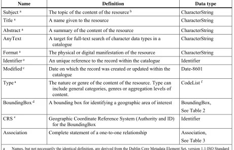
resource.
Tables 1, 2 and 3 define a set of abstract queryables that binding protocols shall realize in their core queryable schemas. Binding protocols shall further specify a record identifier (ID) based on the native platform ID types. Binding protocols shall also specify how the values of core queryable properties shall be encoded in service requests. Binding
Table 1 — Common queryable elements
Name Definition Data type
Subject a The topic of the content of the resource b CharacterString
Title a A name given to the resource CharacterString
Abstract a A summary of the content of the resource CharacterString
AnyText A target for full-text search of character data types in a catalogue
CharacterString
Format a The physical or digital manifestation of the resource CharacterString
Identifier a An unique reference to the record within the catalogue Identifier
Modified c Date on which the record was created or updated within the
catalogue
Date-8601
Type a The nature or genre of the content of the resource. Type can
include general categories, genres or aggregation levels of content.
CodeList f
BoundingBox d A bounding box for identifying a geographic area of interest BoundingBox,
See Table 2 CRS e Geographic Coordinate Reference System (Authority and ID)
for the BoundingBox
Identifier
Association Complete statement of a one-to-one relationship Association, See Table 3
a Names, but not necessarily the identical definition, are derived from the Dublin Core Metadata Element Set, version 1.1:ISO Standard 15836-2003 (February 2003)
b Typically, a Subject will be expressed as keywords, key phrases or classification codes that describe a topic of the resource. Recommended best practice is to select a value from a controlled vocabulary or formal classification scheme.
c DCMI metadata term <http://dublincore.org/documents/dcmi-terms/>. d Same semantics as EX_GeographicBoundingBoxclass in ISO 19115.
e If not supplied, the BoundingBox CRS is a Geographic CRS with the Greenwich prime meridian.
f A “CodeList” is a CharacterString taken from an authoritative list of CharacterStrings or Identifiers. The authority may optionally be identified in the value.
Table 2 — Composition of compound element “BoundingBox”
Name Definition Data type
WestBoundLongitude Western-most coordinate of the limit of the resource's extent, expressed in longitude in decimal degrees (positive east)
numeric
SouthBoundLatitude Southern-most coordinate of the limit of the resource's extent, expressed in latitude in decimal degrees (positive north)
numeric
EastBoundLongitude Eastern-most coordinate of the limit of the resource's extent, expressed in longitude in decimal degrees (positive east)
numeric
NorthBoundLatitude Northern-most, coordinate of the limit of the resource's extent, expressed in latitude in decimal degrees (positive north)
Table 3 — Composition of compound element “Association”
Name Definition Data type
Target Referenced resource Identifier
Source Referencing resource Identifier
Relation The name of the description of the relationship CodeList or Identifier
All realizations of the core queryable properties in a binding protocol shall include all the properties listed in tables 1,2 or 3 even if the underlying information model does not include information that can be mapped into all properties. Core properties that cannot have a value assigned to them because the information is not available in the information model of the catalogue shall be considered as having a value of NULL.
The properties “Title”, “Identifier” and the pseudo-property “AnyText” shall be supported as mandatory queryables in all implementations. Protocol bindings shall describe mechanisms to identify and elaborate on the queryables and operations supported by a given catalogue service.
6.3.3 Core returnable properties
Table 4 — List of common returnable properties Dublin Core
element name
Term used in OGC queryables
Definition Data type
title Title A name given to the resource. Also known as “Name”.
CharacterString
creator An entity primarily responsible for making the content of the resource.
CharacterString
subject Subject A topic of the content of the resource. This is a place where a Topic Category or other taxonomy could be applied.
CharacterString
description Abstract An account of the content of the resource. This is also known as the “Abstract” in other aspects of OGC, FGDC, and ISO metadata.
CharacterString
publisher An entity responsible for making the resource available. This would equate to the Distributor in ISO and FGDC metadata.
CharacterString
contributor An entity responsible for making contributions to the content of the resource.
CharacterString
date Modified The date of a creation or update event of the catalogue record.
ISO-8601 date
type Type The nature or genre of the content of the resource.
CodeList
format Format The physical or digital manifestation of the resource.
CharacterString
identifier Identifier A unique reference to the record within the catalogue.
Identifier
source Source A reference to a resource from which the present resource is derived.
CharacterString
language A language of the intellectual content of the catalogue record.
CharacterString
relation Association The name of the relationship that exists between the resource described by this record and a related resource referenced using the Source
or dc:source property.
CodeList
coverage BoundingBox The spatial extent or scope of the content of the resource.
rights Information about rights held in and over the resource.
CharacterString
The core elements are recommended for a response but do not need to be populated. The support for a common syntax for the returnable properties as a “common” Summary Element Set is defined in the protocol binding clauses.
EXAMPLE The following shows an example query, using the GetRecords operation described in Clause 10.
<GetRecords
service="CSW"
version="2.0.2"
maxRecords="5"
startPosition="1"
resultType="results"
outputFormat="application/xml"
outputSchema="http://www.opengis.net/cat/csw/2.0.2"
xmlns="http://www.opengis.net/cat/csw/2.0.2"
xmlns:csw="http://www.opengis.net/cat/csw/2.0.2"
xmlns:ogc="http://www.opengis.net/ogc"
xmlns:ows="http://www.opengis.net/ows"
xmlns:dc="http://purl.org/dc/elements/1.1/"
xmlns:dct="http://purl.org/dc/terms/"
xmlns:gml="http://www.opengis.net/gml"
xmlns:xsi="http://www.w3.org/2001/XMLSchema-instance"
xsi:schemaLocation="http://www.opengis.net/cat/csw/2.0.2
../../../csw/2.0.2/CSW-discovery.xsd"> <Query typeNames="csw:Record">
<ElementSetName typeNames="csw:Record">full</ElementSetName> <Constraint version="1.1.0">
The response to such a query, might be:
<?xml version="1.0" encoding="UTF-8"?> <csw:Record
xmlns:ows="http://www.opengis.net/ows"
xmlns:xsi="http://www.w3.org/2001/XMLSchema-instance" xsi:schemaLocation="http://www.opengis.net/cat/csw/2.0.2 ../../../csw/2.0.2/record.xsd">
<dc:creator>U.S. Geological Survey</dc:creator> <dc:contributor>State of Texas</dc:contributor> <dc:publisher>U.S. Geological Survey</dc:publisher>
<dc:subject>Elevation, Hypsography, and Contours</dc:subject>
<dc:subject>elevation</dc:subject>
<dct:abstract>Elevation data collected for the National Elevation
Dataset (NED) based on 30m horizontal and 15m vertical accuracy.</dct:abstract>
<dc:identifier>ac522ef2-89a6-11db-91b1-7eea55d89593</dc:identifier>
<dc:relation>OfferedBy</dc:relation>
<dc:source>dd1b2ce7-0722-4642-8cd4-6f885f132777</dc:source>
<dc:rights>Copyright © 2004, State of Texas</dc:rights>
<dc:type>Service</dc:type>
<dc:title>National Elevation Mapping Service for Texas</dc:title>
<dct:modified>2004-03-01</dct:modified> <dc:language>en</dc:language>
<ows:BoundingBox>
<ows:LowerCorner>-108.44 28.229</ows:LowerCorner> <ows:UpperCorner>-96.223 34.353</ows:UpperCorner> </ows:BoundingBox>
</csw:Record>
6.3.4 Information structure and semantics
Some services that implement OGC Implementation Specifications expect a rigid syntax for the information resources to be returned, whereas others do not. This subclause allows an Application Profile to be specific about what information content, syntax, and
semantics are to be communicated over the service. The following items should be addressed in an Application Profile.
a) Identify information resource types that can be requested. In the case of a catalogue service, the information resources being described by the metadata may include geographic data, imagery, services, controlled vocabularies, or schemas among a wide variety of possible types. This subclause allows the community to specify or generalise the resource types being described in metadata for their scope of application.
b) Identify a public reference for the information being returned by the service (e.g. ISO 19115:2003 “Geographic Information – Metadata “). Include any semantic resources including data content model, dictionary, feature type catalog, code lists, authorities, taxonomies, etc.