MOUNT MERAPI ACTIVITY 2006:
ITS IMPACT ON GROUNDWATER ENVIRONMENT Sari B. Kusumayudha
Geology Department, Mineral Technology Faculty, UPN Veteran Yogyakarta JL SWK 104, Condongcatur, Yogyakarta 55283, E-mail: [email protected]
Abstract
During may to June 2006, Mount Merapi, that is located in Central Java, Indonesia has erupted. As we may know, Merapi belongs to one of the most active volcanoes on the world. It is characterized by a very specific type of eruption. Magma of Merapi is very viscous, low gas pressure, and low mobility. When the magma extrudes, it will be accummulated on the vent, forming such a dome. The dome get bigger with time until exceeding its bearing capacity. Due to new magma extrusion, triggered by such vigrations for example earthquake, lead by gravitational force, the dome or apart of it will collapse, forming nuee ardentes. Nuee ardentes occurred on 14th June 2006 was the biggest one during 2006-2007 activity period of Merapi. It reached 7 km distant to the southeast direction. A tourist object, namely Kaliadem, in the Cangkringan District was buried by pyroclastic deposits more than 3 m thick in average. Two volunteers were assassinated in the bunker. Ordinary, the primary activity of Merapi will be followed by the secondary threat, i.e. lahar. Lahar is volcanic mud flow. It is formed when pyroclastic deposits on the upper flank become wet, denser, and heavy, flowing through river valleys down slope. Lahar is very destructive to environment. There were some springs disappear, and groundwater composition change after 2006 Merapi eruption. Key words: Mount Merapi, eruption, nuee ardentes, lahar, groundwater
Introduction
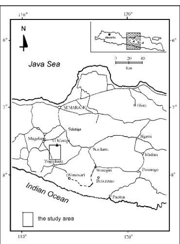
Mount Merapi, the volcano of where the research was done, administratively belongs to the Central Java Province and Yogyakarta Special Province. It is located 30 km northern of Yogyakarta city, and about 30 km western of Magelang town of Central Java (Figure 1). Although the volcano is some time dangerous, it eternally brings berkah to the surroundings by suplying sands, stones, fertile land, and beautiful scenery.
Mount Merapi belongs to the most active volcano of Indonesia, and one of the most attractive volcanoes on the world. Once in almost every 2 to 5 years Merapi increases its activity threatening surrounding environment with its phenomenal nuee ardentes and glowing clouds. In the year 2006, Mount Merapi showed its force, and erupted on 14 June burying a tourist object at Kaliadem of Cangkringan District, Sleman Region.
Figure 1. Map showing the location of the study area
Volcano-tectonic
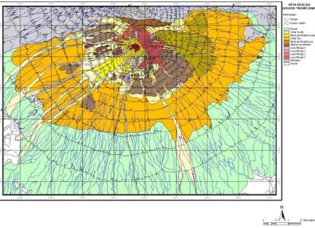
Mount Merapi exiats on the intersection of two volcanoc lineaments, i.e. Ungaran - Telomoyo - Merbabu - Merapi and Lawu - Merapi - Sumbing - Sundoro - Slamet. Merapi is also laid on the meeting point of Semarang fault (North – South) and Solo fault (West – east) (Laporan Tahunan P3G 1980/1981, dikutip dari Kusumayudha 1988).
Figure 2. The geologic map of Mount Merapi
Tabel 1. Persen Komposisi Kimia Endapan Piroklastika Erupsi 1994 (Hammer, 2000)
Senyawa Senyawa Kimia (%)
Smpl 1 Smpl 2 Smpl 3 Smpl 4 Smpl 5 Smpl 6 Rata-rata
SiO2 66.1 66.1 64.7 74.5 72.2 72.6 69.37
TiO2 0.53 0.54 0.5 0.62 0.47 0.52 0.53
Al2O3 15.2 14.5 15.5 12.3 12.1 11.7 13.55
MgO 0.73 0.58 0.75 0.25 0.15 0.12 0.43
CaO 2.06 1.54 2.49 0.18 0.44 0.44 1.19
MnO 0.13 0.11 0.09 0.12 0.08 0.11 0.11
Fe O2 3.61 3.48 4.1 0.96 2.13 2.5 2.80
Na2O 3.54 3.91 3.72 2.92 3.51 3.42 3.50
K2O 5.08 5.9 5.69 5.87 6.23 6.3 5.85
Total 96.98 96.66 97.54 97.72 97.31 97.71 97.32
Hydrogeologic System
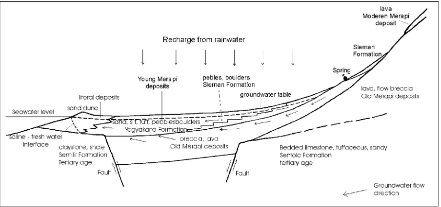
Mature Merapi. Hydrogeologic system model of the souther slpoe of Merapi is shown in the Figure 3 (Sir MacDonald & Partners 1984)
Based on Cash & wright volcanic facies model, Sleman Formation is classified into medial facies, while the Yogyakarta Formation is claasified into diltal facies. The basic difference between the two formations is their grain size of the deposits. Sleman Formation predominantly composed of coubles to boulders fragments, while Yogyakarta Formation is composed of mostly sands. The two formations are then hydrogeologically mentioned as Sleman Aquifer and Yogyakarta Aquifer respectively. On the other hand deposits of mature Merapi built semi confined aquifer generally lies under the formations mentioned before. The basement of the quifers is lava of old and proto Merapi in the proximal and part of medial facies, and Tertiary sediments in the distal facies.
Figure 3. Hydrogeologic system conceptual model of Merapi southern slope
In general there is a clay layer in the depth of 40 m to 50 m bellow the surface, locally separating Yogyakarta Aquifer and the underlain deposits. This phenomenon accur in the Sleman Formation too. The clay layer is intrepreted to be formrd in reduction environment, characterized by its Fe rich content. The thickness of the clay layer ranges 2 m to 5 m.
Both Yogyakarta and Sleman aquifers are classified into intergrain aquifer with groundwater flow southward direction, controlled by hydraulic gradient and topography. In the Bantul Region, southern side of the study area, the aquifer base layer is tuffaceous calcareous sediments of Sentolo Formation and tuffaceous shale of semilir Formation at some places.
Merapi Activity 2006 and Deposits
The deposits in the present time are taken by people as C class mining material with economic value.
There is a significant change of Merapi eruption direction. Previously since 1961 to 1994 the eruption direction was to the west. In 1994, Merapi erupted both west and southwards. In 2006 the biggest eruptions were southeastward. On 14 June 2006 A great pyroclastic flow attacked area of the surrounding River Gendol, of 7 km distant from the center of eruption. The nuee ardentes using the valley of River Gendol as the highway to flow. A tourist object, namely Kaliadem, Jambu village, in Cangkringan District was buried by more than 3 m thick of flow pyroclastic deposits. In this accident, 2 volunteers were assasinated in the bunker when they would like to avoid the nuee ardentes. The valleys of River Gendol and River Opak were then fullfilled by pyroclastic sediments, a bunker was covered, two volunteers died. Thickness of the sediments at River Gendol is 3 m average, and at River Opak is 2 m average. Estimation of volume of the deposits filling River Gendol, River Opak, Kaliadem and surroundings is 276.000 m³, while on the near summit area at elevation of 1700 m above sea level ( 2 km from the summit) to the edge of deposits, the volume is about 5,6 million m³. Temperature of the deposits at the depth of 30 cm to 50 cm, after 6 month deposition was still 8 ⁰C - ⁰C.
0 2 mm
Gambar 2. Sayatan Petrografis Fragmen Endapan Piroklastik di Kali Gendol
Petrologic composition of Merapi eruption 2006 is andesitic: Since rainy seasons of 2006/2007 and 2007/2008, the deposits in the River Gendol and River Opak are gravitationally flowed down as lahar. The lahar generally flow southeast direction following the river channels. Lahars not only occur in River Gendol and River Opak but also in River Boyong, River Kuning in the west parst, and River Woro in the east part of the study area.
Impact on Groundwater Environment
Mount Merapi eruption in the year 2006 has much changed the environment in the study area especially in Umbulharjo and Kepuharjo villages, cangkringan District. Many building and houses were buried by pyroclastic deposits. Plants were burnt and damaged by the glowing clouds. Catles were disturbed, because no more fresh grass to feed. This cause many people were forced to soale their catles, or transfered to the more safe places down slopes. Land surface condition is also changed physically and chemically.
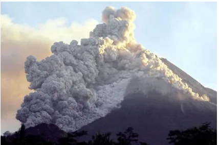
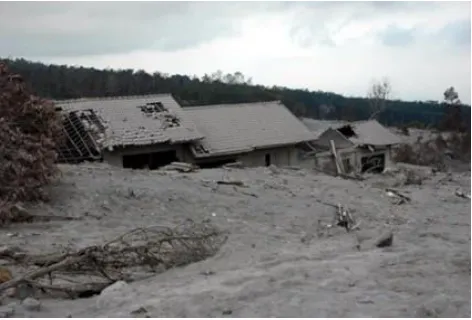
Figure 5. Impact of Merapi eruption:
Kaliadem was buried by >3 m thick of pyroclastic flow deposits
Paralel Nikol Cross Nikol
Plagioklas
Aktinolit
Plagioklas
Aktinolit
Piroksen
Aktinolit
Piroksen
Aktinolit Gelas
Aktinolit
Gelas
Aktinolit
Tabel 2. Imbas Erupsi Merapi 2006 Terhadap Potensi Hidrogeologi
No Location Impact on the environment
1 Kaliadem A tourism object was covered by pyroclastic deposits
Buildings and hauses were buried
Plants were damaged and burnt
Springs were distinct
Road flooded with lahar deposits 2 Kali Kuning Springs covered by lahar deposit
Pipe networking damage 4 Kec. Cangkringan Groundwater quality degradation
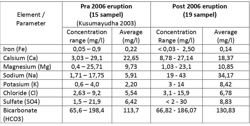
Tabel 3. Concentrations of ellements in groundwater pre and post 2006 eruption
Element / Parameter
Pra 2006 eruption (15 sampel) (Kusumayudha 2003)
Post 2006 eruption (19 sampel) Concentration range (mg/l) Average (mg/l) Concentration Range (mg/l) Average (mg/l) Iron (Fe) 0,05 – 0,9 0,22 < 0,03 - 2,50 0,14 Calsium (Ca) 3,03 – 29,1 22,65 8,78 - 27,14 18,37 Magnesium (Mg) 0,4 – 25,71 9,73 1,03 - 23,1 10,85 Sodium (Na) 1,71 – 17,75 5,91 19 - 43 34,17
Potasium (K) 0,6 – 4,0 2,20 3 - 14 8,42
Chloride (Cl) 2,63 – 9,2 5,54 3,1 - 15,9 6,78 Sulfate (SO4) 1,5 – 21,9 6,42 < 2 - 30 8,83 Bicarbonate
(HCO3)
65,6 – 198,4 113,7 66,82 - 186,07 130,83
Adapun distribusi pH, TDS dan DHL adalah sebagai tercantum di dalam Tabel 4 berikut ini.
Tabel 4. Values of pH, TDS dan EC of groundwater of Pre dan Post 2006 Eruption
Parameter Pre 2006 Eruption (15 sampel) (Kusumayudha, 2003)
Post 2006 Eruption (19 sampel)
Range Average Range Average
pH 6,7 – 8,3 7,2 6,2 - 7,2 6.7
Some groundwater sources were distict, drinking water piping damage by pyrocalstic and lahar deposits. Hydrogeologic condition after 2006 Merapi eruption is the increase of water turbidity, TDS, EC, and some compounds such as Na, K, HCO3, and SO4. The increase of chemical compounds are caused by dissolution of fine grained deposits of ash and dust by rainwater that contaminated groundwater and other water bady. Fine grained deposits of Merapi eruption 2006 is composed of Na2O, K2), CO2, S2, and SO2. On the other hand the concentration of Ca in some water samples are tend to decrease comparing to before eruption. The cause of this phenomenon is interpreted due to chemical composition of new Merapi deposts that is more accidic than the older deposits. New Merapi deposits is more rich of Na-plagioclase than Ca-plagioclase. The deposits also does not contain olivine that rich of Mg. Below is the breakdown of impact of 2006 Merapi eruption on hydrogeologic environment and potebcy of the study area.
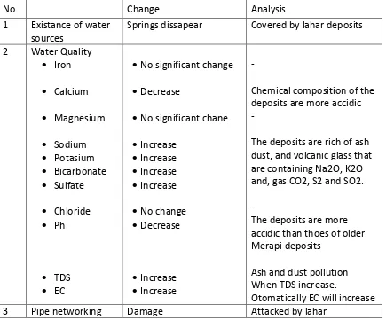
Tabel 6. The changes of hydrogeologic potencies and environments as the impact of 2006 eruption
No Change Analysis
1 Existance of water sources
Springs dissapear Covered by lahar deposits
2 Water Quality
Iron Calcium Magnesium Sodium Potasium Bicarbonate Sulfate Chloride Ph TDS EC
No significant change
Decrease
No significant chane
Increase
Increase
Increase
Increase
No change
Decrease
Increase
Increase
-
Chemical composition of the deposits are more accidic -
The deposits are rich of ash dust, and volcanic glass that are containing Na2O, K2O and, gas CO2, S2 and SO2.
-
The deposits are more accidic than thoes of older Merapi deposits
Ash and dust pollution When TDS increase.
Otomatically EC will increase 3 Pipe networking Damage Attacked by lahar
Conclusions
1. Mount Merapi eruption of June 2006 had produces pyroclastic deposits 5,6 million m3 whole volume and 276,000 m3 covering arround River Gendol, River Opak and Kaliadem touristm location. Area covered by the deposits is about 80,000 m square. The deposits consits of boulders to ash and dust grain sized with andesitic composition.
2. Pyroclastic deposits of Merapi eruption 2006 created lahar in River Gendol, River Boyong, River Kuning, and River Woro, with sediments of sand to boulder grain size with andesitic composition.
3. Merapi deposits of 2006 eruption buried about 80,000 m2 area with 2 – 3 m thickness. Some buildings, hauses, groundwater sources, piping networking, and degrade water quality in general. The water quality whics are change are the incrrease of turbidity, TDS, EC, conentration of Na, K, HCO3, and SO4. Onthe other hand, the concentration of Ca and pH decrease.
References
1. Cash, R.A.F. & Wright, J.V., Volcanic Successions Modern and Ancient, 1987, Allen & Unwin Ltd, London, 528
2. Camus, G., A. Gourgaud, P. C. Mossand-Berthommier, P. M. Vincent, 2000, Merapi (Central Java, Indonesia): An outline the structural and magmatological evolution, with a special emphasis to the major pyroclstic events, Journal of Volcanology and
Geothermal Research, Vol 1000, Elsevier, 139 - 163
3. Hendrayana, H., 1993, Hydrogeologie und grundwasser gewinnung im Yogyakarta
becken, Indonesia, Disertasi, Universitas Achen, 117
4. Kusumadinata, K., 1979, Basic data of volcanoes in Indonesian, Departemen Pertambangan dan Energi, Direktorat Vulkanologi, 820
5. Kusumayudha, S.B., 1988, Magmatic Evolution of Mt. Merapi Based on Petrographical
Analysis, Semester Gasal Seminar UPN Veteran Yogyakarta, 50.
6. --- , 1993, Groundwater Geochemistry of Mount Merapi's Southern Slope Area, Java,
Indonesia, Master of Science Thesis, AIT, Bangkok, Tidak dipublikasikan, 239
7. --- , 1995, The Safety Factor and Critical Height of Mt.Merapi Lava Dome Based on
Two Dimensional Slope Stability Analysis and Graphical Method, Merapi Decade
Volcano International Workshop and Symposium, Yogyakarta.
8. Kusumayudha, S.B., A. Sungkowo, I.B. Jagranata, 2001, Groundwater Quality of Bantul
Area: Environmental Impact (?), Pros Symposium on Natural Resources and
Environment Management, UPN Veteran Yogyakarta
9. Newhall, C. & Bronto, S., 1995, An Explosive History of Merapi Volcano, Central Java, Merapi Decade Volcano International Workshop and Symposium, Yogyakarta.
10.Newhall, dkk (11 orang), 2000, Ten Thousand (10,000) Years of Explosive Eruptions of Merapi Volcano Cntral Java: Archeological and modern implications, Journal of
Volcanology and Geothermal Research, Vol 100 (2000), 9 - 30
11.Sir MacDonald & Partners, 1984, Greater Yogyakarta Groundwater Resources Study, Vol 3 Groundwater, Departemen P. U., Tidak dipublikasikan, 116
12.Van Bemmelen, R.W., The Geology of Indonesia, Vol 1A, 1949, The Hague, Martinus Nijhoff, 732
13.Volcanological Survey of Indonesia, A Guide Book for Merapi Volcano, 1995.