Procedia Environmental Sciences 28 ( 2015 ) 623 – 629
1878-0296 © 2015 The Authors. Published by Elsevier B.V. This is an open access article under the CC BY-NC-ND license (http://creativecommons.org/licenses/by-nc-nd/4.0/).
Peer-review under responsibility of Sustain Society doi: 10.1016/j.proenv.2015.07.073
ScienceDirect
The 5th Sustainable Future for Human Security (SustaiN 2014)
Recognizing indigenous knowledge on agricultural landscape in
Bali for micro climate and environment control
I Gusti Agung Ayu Rai Asmiwyati
a*, Made Sudiana Mahendra
a,
Nurhayati Hadi Susilo Arifin
b, Tomohiro Ichinose
ca Faculty of Agriculture, Udayana University, Bali 80361, Indonesia
bDepartment of Landscape Architecture, Bogor Agricultural University, Bogor 16680, Indonesia cFaculty of Environment and Information Studies, Keio University, Tokyo Japan
Abstract
Physical and cultural conditions are fundamental factors in creating the formation of a terraced agricultural landscape.Studying the formation of terraced landscape is essential in order to understand the interaction between human activities and the natural processes that can be used to strengthen the adaptive capability in response to climate change and environment control. Terraced agricultural landscape in Batukaru Mountain’s slope was selected as one of major terraced rice landscapes in Bali. The spatial pattern distribution and characteristics of landscapes were investigated using geographical information system, and the indigenous knowledge mechanism behinds the sustainability was discussed physically and culturally. The results showed that the harmony between the vertical pattern of the landscape, shape of terrace, irrigation system and conservative vegetative landscape along the steep slope and high elevation has protected the landscape. The controlled irrigation system has assured water to flow from the top to the bottom and even to places that seem impossible to reach by natural river water. The intangible agricultural indigenous concept called Tri Hita Karana was adhered to in organizing the layout of landscape elements such as forest, temple, terraced paddy field, irrigation network, and settlement which will continue to affect the sustainability throughout years.
© 2015 The Authors. Published by Elsevier B.V. Peer-review under responsibility of Sustain Society.
Keywords: rice terrace field; cultural landscape; conservation; subak water irrigations
* Corresponding author. Tel.: +62 -361-434342; fax: +62-361-702801. E-mail address: [email protected]
© 2015 The Authors. Published by Elsevier B.V This is an open access article under the CC BY-NC-ND license (http://creativecommons.org/licenses/by-nc-nd/4.0/).
1.Introduction
Human health, homes, food security and safety are all likely to be threatened by the rising of global temperatures with the climate change. Farming, because its production continuity depends closely on the water sufficiency, becomes the most unstable sector and is at greatly critical risk as the climate change leads to increasing air temperature and causes changes in the rainfall pattern. A deep understanding about the interaction between human activities and natural process in agricultural landscapes is required in order to improve and strengthen the adaptive capability in response to the climate change since new patterns and functions for natural landscapes to sustain will be needed while adapting to favorable conditions for humans represent effectively created landscape management.
Agricultural landscapes, as a part of the cultural landscape have been reflecting economic, spiritual, ethical and aesthetic values throughout their history1. The formation of a terraced agricultural landscape is created by interaction process between physical conditions (i.e. soil, climate and hydrology) and cultural factors (i.e. tradition, religious philosophy and practice). Terraced agricultural landscape in Batukaru Mountain slope is recognized as one of the wonder wet land civilizations in Bali. During the past thousand years’ development and cultivation, the terraced landscape has been sustained in all climatic circumstances and created a unique landscape that has not changed. It is believed the rice field terrace has been in existence and well managed since the IX century by the local Bali irrigation system which is known as Subak2. A part of its terraced rice landscape which is located in this Jatiluwih
village’s slope has also been selected as a World Natural and Cultural Heritage site in 2012.
An amount of research has been done to study the characteristics of the rice ecosystem in Batukaru’s mountain
slope of Bali such as birds in rice paddy terraces3 and the water management system by Subak4. This study
investigates the spatial pattern of the Batukaru Mountain’s terraced agricultural landscape by geographical information system.The intangible indigenous mechanism behinds its spatial pattern and agro-cultural sustainability in response to their physical adaptation was discussed physically and culturally.
1.1.Study area
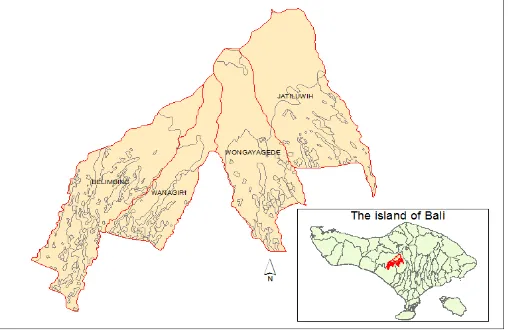
The study area is situated in the middle part of Bali, Indonesia to includes four villages: Belimbing, Wanagiri, Wongayagede, and Jatiluwih in Tabanan Regency where rice field landscape in Bali is mostly located. The study area has approximately 850 km2 and a range of land surface types. The site is high in the Batukaru mountainous area with an elevation ranging from 300 to 2250 m dominated by a tropical climate with the mean annual temperature is 27ºC. The area is strongly influenced by two monsoons which bring the dry and rainy seasons. The total annual precipitation is 3210 mm with the majority of rain between December and February and the dry season falls from May to September5. The climate pattern in the study area is on C type which means medium wet area. There are about eleven major river systems in the study area. The soil and the vegetation are of rich diversity and both correspond to the tropical mountainous climate condition. Fig. 1 shows the location of the study area.
2.Data and Methods
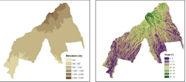
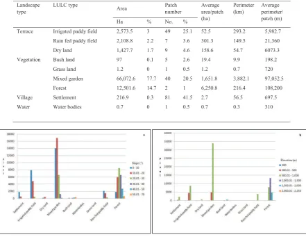
To support the landscape spatial pattern analysis, the landscape was classed using the land use map of 2008 [6] and the river map of Bali. A digital elevation model derived from Shuttle Radar Elevation Data was created (Fig. 2). All the digital data were re-projected into the UTM WGS 84 projection zone 50S using ArcMap 10.1. In order to understand the local history and culture, living customs philosophy, and natural resource management, field investigation by historical literature review and interview of local farmers during 2002–2003 was compiled. There were four main landscape characteristics that modified from the previous study of agriculture landscape pattern8 and can be identified in this landscape. Those landscapes were terraced, dominated by paddy field and dry land, vegetation dominated by forest and mixed garden, water, and village landscape dominated by settlements (Table 1).
Table 1. Landscape and land use classes
Landscape Land use General description
Terrace Irrigated paddy field Terrace paddy field located in above of 5º depends closely with river
water irrigation
Rain fed paddy field Paddy field with local red paddy variety depends on rainfall
Dry land
Vegetation Mixed garden Complex of cultivated and semi-cultivated plants
Bush land Natural bushes
Grassland Natural grass
Forest Tropical rainforest
Water Water bodies Permanent open water except river
Village Settlement Residential area with linear and regular house pattern
Spatial analysis of the slope and elevation steepness with regard to the landscape classes of Batukaru’s landscape
was carried out in order to identify the spatial distribution and transformation pattern among landscape classes from the top to the bottom of the study area. Raster data were super-imposed onto each of the classified slope and elevation. The elevation and slope map can be seen in the Fig. 2. The underlying cultural indigenous knowledge which contributes to the sustainable system of agricultural landscape in response to the physical conditions was discussed descriptively.
3. Result and Discussion
3.1.Landscape composition and patterns
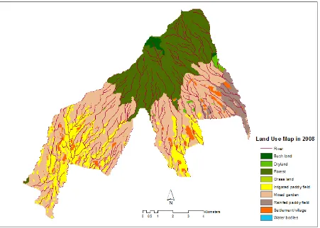
The classification map of Batukaru’s agricultural landscape is shown in Fig. 3. Table 2 shows the area pattern
characteristics of the Batukaru’s agricultural landscape. The landscape of vegetation was the largest landscape in the study area (92.55%) followed by the terraced landscape (7.19%). Mixed garden was the dominant landscape classes covering 77% of the total area. Forest is the second extensive landscape class (14.71%) followed by irrigated paddy field (3.03%) and rain-fed paddy field (2.48%). The remaining landscape classes such as dry land, bush land, grass land, water bodies and settlement are a relatively small percentage of the total area. The pure spring water of the river flows from top to the bottom throughout the year with the length of 471 km.
Fig. 3. Landscape types and distribution
3.2.Vertical characteristic of landscape types by slope and elevation
few settlements were still can be found in the slope of 30-40°, nearby the dry fields. For the terraced landscapes, paddy field and dry field were both primarily distributed on the slopes range from 5-20° and only few dry land fields were located in the slope from 30 to 50°. A considerable number of paddy field and dry land still can be found on a slope of 20-30°. This result corresponds with the studies carried out in other Asian areas such as Japan and China where terraced paddy field are generally located in above of 5º and 10º, respectively7,8.
Table 2 Pattern characteristics of the Batukaru’s agriculture landscape
Landscape
Fig. 4. Histogram of land use types by the range of slopes (a) and elevations (b)
The top of the mountain that has elevation between 1500-2250 m was naturally covered by the bush land. The rain tropical forests were located below the bush land and spread above the altitude of 500 m in the study area. The mixed garden which consists of complex plants was mainly distributed from 300-1000 m in elevation. Terraced landscapes including the irrigated and rain-fed paddy fields were mainly distributed on the elevation from 300-1000 m and the dry land fields were primarily found at the elevations of 500-1000 m. Settlements and water bodies (except river) were mainly distributed in the same elevation of terraced landscapes. The linear village settlement was distributed scattered particularly along the main road.
Most of terraced landscapes, village and water bodies were located at lower level of the forest and mixed garden. This finding demonstrates a local harmony of vertical composition of landscape pattern by slopes and elevations which wisely conserves water and soil and flows material and energy effectively and efficiently. The physical shape of terrace for paddy field cultivation represents an important role to prevent soil erosion/landslides and maximally utilize of water supply before it is distributed to the lower paddy fields. The presence of water flow and circulation of water in terrace paddy fields also reflects multi functions to prevent flooding and recharge ground water. The terraced paddy field shape was also important to absorb phosphorus acid, control the growth of weeds and the flow of nitrogen, and the local climate control through the process of evapotranspiration of plants.
3.3.Implementation indigenous knowledge in response to physical factors
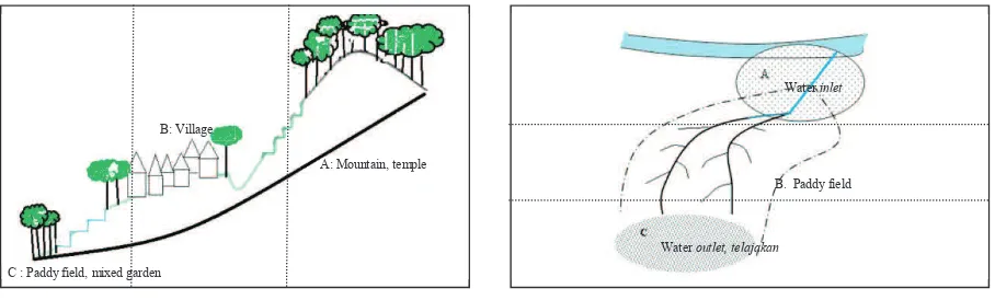
Over the past thousand years and generations, people accepted the local wisdom concept called Tri Hita Karana. The concept was implemented on human space arrangement from micro scale spaces such as personal paddy field, house, temple, to macro scale spaces such as subak region, village, and town. The closest highest place (mountain, hill) or major life resource based places and sunrise-sunset orientation based places were both used to define the
landscape element direction and allocation. Those two direction concepts arrange the people spatial’s distribution not
only vertically but also horizontally. Figure 5 shows the implementation of Tri Hita Karana concept in the spatial pattern.
Tri Hita Karana concept: A: Parahyangan (Man-God) B: Pawongan (Man-man) C: Palemahan (Man-environment)
Fig 5. Implementation the traditional living concept Tri Hita Karana on spatial pattern
Local people strongly believed that human life has to always keep relationships in harmony and good balance to the god (Parahyangan), people (Pawongan) and nature (Palemahan). Accordingly, worship temples as a reflection place of human and God relationship can be found in sacred places such as in forests, spring water, lakes and irrigation canals. The holy Hindu ceremony was regularly done in those temples in particular times which have been related with planting seasons and macrocosm system. Pawongan concept was reflected by the good interaction between local people in communal groups such as the subak and the village regulated by rules. Palemahan concept was represented by having respect for nature with protecting hazardous high risk places from intensive development and mostly keeping it vegetated as forest or semi-intensively used for mixed garden, bush land and grassland.
People’s life concept in personal paddy field was shown by two temples in the inlet and outlet water canals, terrace of paddy field for interactive farmer’s workspace and, telajakan, a local name of mixed garden, usually located in river bank and steep slopes to conserve paddy field. These traditional agricultural beliefs and practices which have created agricultural landscape elements are interrelated and influence each other, composing a regular indigenous pattern of life in harmony with the nature.
Water resources play a pivotal role in maintaining the sustainability of irrigated terraced paddy field which need
lots of water in both the dry and rainy seasons. To regulate water allocation and utilization control effectively and efficiently, the farmers have developed a traditional water organization called Subak. Using their traditional measurement scale, local people in Subak built and maintained controlled canals and ditches to translocate water in upper terraced paddy fields down through the communal Subak water temple to private terraced paddy fields. Obstacles of sites which are located far from the river or higher than the river were overcome by building dams to collect water from upper streams and tunnels.
Water surplus in upper terraced paddy fields in the rainy season was maximally utilized to water simple fish ponds built in the paddy field before it was transported to the other areas. The scarcity of water in the dry season was tackled by planting transitional horticulture plants that need relatively less water instead of paddy. This aims to rehabilitate the soil structure and control paddy diseases and pests. During fallow time in paddy field, farming work was focused in maintaining a mixed garden. This system shows the traditional agro responses in facing local climatic situation that has allowed paddy fields to continue to be economically and physically productive throughout the year.
4. Conclusions
In this work, a typical agricultural landscape in Batukaru’s slope was revealed and proposed as an outstanding example of sustainable development that copes with environmental condition mainly physical obstacles (soil, water, climate) throughout the years. The stability of agricultural landscape was attributed largely to its unique vertical distribution pattern of landscape components. The cycle of natural material and energy in the physical slope and elevation condition enhanced by the adaptive irrigation management system have provided the foundation for the sustainable landscape development. The indigenous agricultural knowledge base, Tri Hita karana, has fulfilled efficient utilization of natural resources and secured the natural system by spatial pattern arrangement vertically and horizontally. The relevant traditional knowledge can be adopted in the modern conservation and sustainable development to improve and strengthen an adaptive capability in response to the climate change.
References
1. Farina A. Principles and methods in landscape ecology. London: Chapman and Hall; 1998.
2. Purwita IBP. Kajian tentang sejarah subak di Bali, In: Pitana IG, editor. Subak an irrigation traditional system in Bali.. Denpasar: Upada Sastra; 1993. p. 47.
3. Ichinose, T, Yokokawa A, Asmiwyati, IGAAR, Arifin, NHS, Kataoka M. Relationships between bird distribution and land use in an agricultural landscape, Bali, Indonesia. In: McNeely JA, McCarthy, TM, Smith, A, Olsvig-Whittaker L, Wikramanayake ED, editors. Conservation biology in Asia. Kathmandu: Society for Conservation Biology Asia Section and Resources Himalaya Foundation; 2006. P. 294-302.
4. Sutawan N. Subak system in Bali: its multi-functional roles, problems and challenges. Proceeding the seminar “World Water Forum”. 2002.
P. 79-95.
5. Aldrian E, Susanto RD. Identification of three dominant rainfall regions within Indonesia and their relationship to sea surface temperature,
International Journal of Climatology 2003;23:1435-1452.
6. As-syakur AR. Land use and land cover change in Bali Province. J Eco-trophic 2011; 6(1):1-7 7. Nakajima M. Sustainability of rice terraces. J Geography 1996; 105(5):547-568.