Understanding the
Impacts of Recurrent Peat Fires in Padang Island –
Riau Province, Indonesia
Memahami Dampak Kebakaran Lahan Gambut yang Berulang di Pulau Padang-Provinsi Riau,
Indonesia
Ari Susanti1*, Oka Karyanto1, Agus Affianto1, Ismail1, Satyawan Pudyatmoko1, Trias Aditya2, Haerudin3, & Hendra Arditya Nainggolan3
1
Faculty of Foresty, Universitas Gadjah Mada, Jl. Agro No. 1, Bulaksumur, Sleman 55281 2
Department of Geodetic Engineering, Faculty of Engineering, Universitas Gadjah Mada, Jl. Grafika No. 2, Bulaksumur, Sleman 55281
3
Department of Sociology, Faculty of Social and Political Sciences, Universitas Gadjah Mada, Jl. Sosio Yustitia, Bulaksumur, Sleman 55281
*
Email: [email protected]
https://jurnal.ugm.ac.id/jikfkt
RESEARCH PAPER
Article history :Received (masuk): 24 November 2017
Accepted (diterima): 30 January 2018
KEYWORDS Indonesia Padang Island peatland ecosystem peat fires
impacts
ABSTRACT
Introduction
I
ndonesia hosts about 20 million ha of peatland, the world’s greatest area of tropical peatland (Page et al. 2007). Around four ha of this tropical peatland are located in Riau province, making Riau one of thelargest peatland provinces in Indonesia (Susanti 2016). Most of these tropical peatland and its forest has been intensively drained and subsequently converted into agricultural lands to satisfy the global demands for fiber, fuel, and food such as timber, oil palm, and rubber plantations and other food crops as well as for the sake of development such as for transmigration sites (Susanti & Maryudi 2016). A study on the
expansion of oil palm plantation projected that around 23% of the peatland in Riau will be occupied by oil palm plantations in 2030 (Miettinen et al. 2012). For these developments, tropical peatland in Riau has been experiencing massive bio-physical and liveli-hood changes in the last two decades. The peatland ecosystem has changed from previously being frequently inundated and moist ecosystem into man-made drained ecosystem due to peat forest conversion into agricultural lands such as palm oil and pulp-paper plantations and other food croppings. The livelihood has shifted from previously lived with nature into more anthropocentric which dominated
© Jurnal Ilmu Kehutanan-All rights reserved
INTISARI
Pulau Padang yang terletak di Provinsi Riau, Indonesia mengalami kebakaran lahan gambut cukup parah dan berulang pada tahun 2014 dan 2015 yang mengakibatkan degradasi ekosistem gambut dan kehidupan masyarakat. Oleh karena itu, seharusnya analisis kebakaran lahan gambut tidak dapat dapat dipisahkan dari konteks sosial ekonomi dan politik lokal. Sudah banyak tulisan yang menganalisis tentang kebakaran lahan gambut terutama terkait dengan besarnya kebakaran, tetapi sangat sedikit yang menganalisis hubungan antara sistem ekologi dan sistem kehidupan masyarakat. Artikel ini menganalisis bagaimana faktor-faktor penyebab kebakaran lahan gambut juga mengakibatkan degradasi yang terus-menerus di Pulau Padang dan bertujuan untuk berkontribusi pada pemahaman yang lebih menyeluruh mengenai bagaimana faktor-faktor tersebut bekerja, saling terkait, dan secara terus-menerus mempengaruhi proses degradasi lahan gambut serta dampaknya terhadap pembangunan ekonomi lokal dan kehidupan masyarakat. Penelitian ini menerapkan pendekatan multi-disiplin yang meliputi analisis data penginderaan jauh, dokumen sejarah dan peraturan terkait. Penelitian lapangan dilakukan secara intensif di Pulau Padang, meliputi serial diskusi kelompok terfokus dan wawancara. Kami menemukan bahwa permintaan pasar global akan komoditas pertanian berkontribusi terhadap drainase lahan gambut skala besar untuk pertanian monokultur pada lahan gambut. Tingginya ketergantungan terhadap pasar global komoditas dan pertanian mono-kultur telah menciptakan kehidupan masyarakat yang rentan. Hal ini terutama karena besarnya fluktuasi harga komoditas pertanian di pasar global. Di samping itu, pertanian monokultur pada lahan gambut cenderung tidak berkelanjutan karena mensyaratkan pengeringan lahan gambut dengan drainase, menawarkan pilihan sumber penghasilan masyarakat yang lebih sedikit dan meminggirkan pengetahuan lokal tentang paludikultur yang sudah dipraktekkan selama berabad-abad di Pulau Padang.
by man-modified nature and commodity based livelihood (Susanti & Burgers 2012).
Fire has been significantly used to prepare land in this region for agricultural purposes both by large scale companies and smallholders such as timber and oil palm plantations, transmigration sites and shifting cultivation. The main reason is mainly because it is cheap and effective (Tomich et al. 1998). A law No. 32/2009 on environmental protection was issued in 2009 to prevent the use of fire to clear lands (Article 69-1b), fire remains important as means for land clearing. It is indicated by the massive fire events in 2014 and 2015 where large numbers of plantation companies were being investigated in connection with these extensive fire and haze and suspected of deliberating lighting fires for land clearing purposes (Deutche Welle 2015). With these developments on peatland, the tropical peatlands in Riau become the most peat fire prone area. In addition, peat fire with its regional haze impacts has significant consequences on economic and also politics locally, nationally and globally.
Padang Island of Riau Province is one of the peat islands in Riau Province which has been severely impacted by recurrent fires especially in 2014 and 2015.
Much has been written about peat fires especially the magnitude of the fires. However, the process on how
the drivers of the peat fire interplay and continuously feeding the process of peatland degradation and
impoverishment gained only scant attention. In addition, analyzing peat fires should not be isolated
from the local socio-economic and political contexts. Therefore, this paper aims to contribute to more
holistic understanding on how the mechanisms and processes of the fire events on the peatlands, the linkages between ecological and livelihood system of
peatland and its impacts on local economic development and people’s livelihood.
Material and Methods
This study applied a multidisciplinary approach which includes bio-physic and socio-economic
perspectives and two levels of analysis namely landscape level and site-specific level. The landscape (island) level assessment focuses on land use/cover
and the peatland drainage and fire in the region. In the site-specific level, the focus is on investigating the
relationship between fire and livelihood.
The maps of spatial plan were used to delineate the area of peatland which designated for non-conservation areas which subject to disturbances (drainage and conversion for intensive management). Within this area, canal mapping within acacia plantation was done manually by using very high spatial resolution (0.2 x 0.2 cm2) of airborne images, as well as LiDAR DTM that both acquired in October
2016. These datasets were also used for land cover classification, performed by on-screen digitation.
These images allowed the identification of very detail land cover, i.e., identify small scale rubber plantation,
even individual tree of sago species. To preserve the accuracy, the classification was supervised by an
expert with experience on the field, and later evaluated by second interpreter. On the other hand, hotspot datasets in 2014 and 2015 were downloaded
from FIRMS server (Fire Information for Resource Management System). Using the canal map and fire
hot spots distribution, we located the hot spots relative to the canals within gradual distance from 1
km to 10 km as well as relative to the location of peat forest.
sites which includes series of FGDs and in-depth interviews.
Results and Discussion
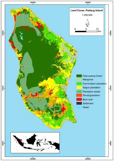
Land cover and land use in Padang Island
Padang Island consists of area around 112
thousand ha with around 30 thousand inhabitants (Central Bureau of Statistics 2016). Padang Island is low land with mean sea level elevation 2.11 m and
around 60% of the landscape of Padang Island is peat with depth up to 12 m. Peat forest and mangrove forest
had dominated the landscape of Padang Island (Brady 1997). Recent land remote sensing data shows that
peat land in Padang Island has been used for industrial forest plantation (17%), sago both natural and
plantation (13%) and rubber plantation (12%). This landscape is the outcome from long-term processes of exploitation by various actors with different scale and
intensity.
Before the Dutch colonial era, the forest management and exploitation was controlled under the local leaders within the structure of kingdoms or sultanates. This continued until the agrarian law was enacted in 1870 by the Dutch colonial government. Through this agrarian law, the Dutch colonial government declared that all lands including forest lands which were unclaimed as the state lands. Within this agrarian law, the forests in outer islands such as in Padang Island became state lands although the
kingdoms and sultanates were still involved in the operation of forest management and exploitation and
local community could have access to natural forests as their sources of construction timbers for houses,
bridges, and fishing boats and other non-timber forest products (Obidzinski & Kusters 2015). Padang Island
has been known as a producer of high quality timbers such as ramin (Gonystylus bancanus), punak (Tetramerista glabra), and meranti bakau (Shorea
uliginosa).
After the national independence, forest resources became important resources for national develop-ment (Susanti & Maryudi 2016). Therefore, national government took control of the management and exploitation of state forests (Susanti & Budidarsono
2014). This was done by the enactment of Basic Forestry Law in 1967 through which forest
concessio-naries were formed to execute forest exploitation especially in outer islands. This new framework led to
the operation of forest concessionary PT. Satria Perkasa (Uni Seraya Group) in Padang Island which
started the operation in 1971. The total logging area 100 thousand ha in which selective cutting and
non-drainage forest management was applied. The operation of this forest company last for one decade and it closed the operation in the Island in 1982. Local
communities continue to depend on natural forest especially for construction timber and non timber
forest products. Recently, those valuable timbers become more valuable because of their rare existence
in the island. As illustration, in 2005 ramin (Gonystylus bancanus) entered the CITES list of
critically endangered species.
Besides timber, Padang Island has been well known as a producer of high quality sago flour for
European market. The exploitation of sago has already started in the Dutch colonial era. In 2015, Padang
Island produced almost 40 thousand tons of sago flour (Central Bureau of Statistics 2016). Previously sago
was harvested from the nature and started in 19th century sago was cultivated in non-drainage deep
peatland as an agriculture commodity. Sago accumulates starch in its trunk and it is can be
harvested when it reaches seven years old. Selective cutting was employed in sago harvesting. The regeneration of sago plantation mainly depends on
natural regeneration. Sago also became the last resort for local communities when during the crisis such as
discontinue of rice supply due to wars or certain political crisis and long dry seasons. However, the
sago farm and sago mills are mainly operated by relatively large scale companies and to serve export
(Karyanto et al. 2016).
Rubber was brought to Padang Island before the
national independence, mainly to serve global market. In fact, rubber has become the main source of income
for the community at Padang Island. Rubber has been cultivated traditionally by farmer at household level. Small scale drainage with narrow canal with
maximum width up to 1.5 m has been applied in rubber cultivation. The planting materials were
sourced from various and unregistered resources which led to high variation in productivity.
Depending on the intensity of management, the latex production could start at seven years and it could
reach up to fifty years.
The coconut farm was introduced in 1980’s by the government as part of national land titling program–
so called PRONA, which involved around 200 households. Coconut becomes a staple grocery for
households in the island, especially to prepare their daily meals. Most of the coconut trees have passed the productive age and increasingly disturbed by pest
such as beetle and monkey. The outbreak of the beetle and monkey as pests followed the massive peatland
drainage for the establishment of acacia (Acacia spp) plantation is the island. The conversion of peat swamp
forest into acacia plantation has disturbed the availability of food stock for monkeys and therefore
the monkey began to roam around the coconut and other food crop farms. For this reasons, coconut
farmers have been increasingly converting their coconut plantations into rubber plantations.
With the ever increasing demand for palm oil products several farmers joined the rush for oil palm plantations. However, the growth of oil palm plantation in the island is relatively slow. This might be explained by the absence of oil palm mills which led to less lucrative financial benefits for the growers compared to those which are close to the oil palm mills. The oil palm fresh fruit bunch (FFB) should be processed within 48 hours to maintain the quality. The substantial distance to the oil palm mills could lead to substantial decrease of quality which also could lead to lower price of FFB. In addition, the cost of oil palm cultivation on peatland is much higher compared to those on mineral soils and thus less profitable (Budidarsono et al. 2012).
The landscape in Padang Island has experienced massive changes when the industrial plantation forest (HTI) concession came to the island in 2009. The concession converted more than 40 thousand ha of deep peat forest land into acacia plantation to support pulp and paper industry (Ali 2012). For the establishment of new acacia plantation, massive drainage has been used to enable optimum growth condition for acacia.
Figure 1 . Land cover/land use of Padang Island of 2016
Underlying causes of peat fire events
The increasing global demands for food, fuel, and
fiber have led to never ending searching for new frontiers which can be exploited (Turner 1990). In
addition, the needs for development of regions especially new established autonomous regions also accelerate the colonization speed of new lands
through various government programs (Susanti & Maryudi 2016). As the fertile mineral soils have been
occupied, recently ecologically vulnerable and less fertile peatlands become new frontier for lands and
natural resources (Susanti & Burgers 2012). This notion has brought remote areas such as Padang
Island to connect to the broader economy such as industrialized or global economy through the production chains (Barbier 2007). As consequences,
peatlands become the targets for commodity productions such as high quality timbers, sago,
rubber, and recently acacia plantation to support pulp and paper industry. For those developments,
peatlands have been exploited. The natural timber exploitation and sago cultivation were mainly done
without peat drainage because they are native to peatlands. However, the introduction of exotic species
such as rubber and acacia demand massive drainage of peatlands. The peat drainage has systematically influenced the water system on peatlands led to peat
dryness and deteriorate the “sponge effect” of peatlands (Andriesse 1988).
The use of small scale drainage in long term rubber cultivation has slowly impacted the shore lines of the island, particularly the intrusion of saltwater and peat subsidence. These have led to the deterioration of rubber, sago, and fruit trees and forced communities of the affected areas to move to deeper peatlands and establish their new houses and farms. Sungai Anak Kamal is an example of new established village as the result of saltwater intrusion and peat subsidence in Pelantai village – a shore line village in adjacent to Sungai Anak Kamal village.
In the case of acacia plantation, it drained peatlands through (a) massive drainage to maintain optimum growth condition and (b) high rate of transpiration. Acacia spp is an exotic species to peatland and its optimum growth condition is on
relatively dry soils. Therefore, massive drainage is necessary to maintain the required water level at 80
cm depth for optimum growing. Acacia spp is a fast growing species with short rotation which produce
biomass in the form of fiber for pulp and paper. Therefore, it has very high transpiration rate to
support the photosynthesis processes and maintain its metabolisms.
This massive drainage and in combination of long dry season such as in 2014 and 2015 where atmospheric condition was heavily influenced by El Nino Sothern
Oscillation (ENSO) made the area prone to fires. During this period, around 20% of Padang Island was
burnt and the areas surrounding the acacia plantation become the most vulnerable and prone to fire during
dry seasons and flood during wet season. This could occur particularly because the water management and
canal system do not consider peat hydrology unit in the whole island. Instead, the concession holder only focuses on water management inside its concession.
The consequences are quite severe for the island. As illustration, in the wet season, the concession has to
maintain the water level at 80 cm by pumping out the excess water through outlet canals to the area outside
concession. This results in erosion of outlet canals and flooding at the area around the outlet canals. In
contrast, during the dry season, the concession maintains the water level at 80 cm by retaining the
water inside the concession. As results, the outlet canals which were already eroded and deepened suck all the water from the areas around the outlet canals.
This leads to peatland dryness and fire-prone areas.
Impacts on livelihood
It is clear that the previous and current peatland
utilization of peat land also impacted the livelihood in the region. This section analyzes how the previous and
current peatland utilizations have led to vulnerable livelihood of local people.
Monoculture source of income and vulnerable livelihood
Rubber is the most dominant commodity which is produced in Padang Island to serve global market
and becomes the main source of income for most of households. Most households tend to be specialized
in certain commodity production. Within this production chain structure, the daily income of
households in Padang Island is determined by the price of the commodity in the global market. As the
price of latex in global market decreases, the income of the households will also decrease. The decreasing trend of latex price in the global market in the last
years has been substantially influencing the income of the households in the island. In addition, the
changing global climate which has led to high uncertain of weather also influenced the production
of latex. During the rainy days or very dry seasons, the production of latex decreases. Similar stories also
occur on other commodities production chains. Within this monoculture livelihood scheme,
households have limited alternative sources of income leading to less resilient and vulnerable livelihood.
The situation becomes worse because most of the households have no access to credit with low interest such as credit from the government bank or cooperation. This opens the way for private entities – so called to `toke` provide the financial services with higher interest, ranging from 15% to 60%. The loan could be in the form of staple groceries or cash and the
households should pay back the loan with the harvest of their farm, in this case latex. Within this framework, the households gain lower price of their
latex compared to market price. This bounding system is so called “ijon”. With this system the most of
the households encounters difficulty in paying back
their loans and sometimes is shackled to the loan from the `toke` for their whole life.
High dependency and lack of initiatives
This patron-client relationship such as the household and the “toke” is also aggregated at island level. The function of Padang Island as the producer of
agricultural commodities to serve global market has put the island in the periphery in the whole
production chain. By history, Padang Island has always been the frontiers for land and natural
resources to serve greater economic centers such as industrial centers and intermediate markets such as
Bengkalis and Selat Panjang which have better connection with global market in Singapore, Malaysia
and Europe. This specialization on the production chain such as raw material producer, processing industry and market place has influenced the
development of economic infrastructures in the area. As consequence the industrial and market centers
have stronger economy compared to the raw material producers such as Padang Island. In most cases, these
economic centers could determine the consumption pattern for the peripheries to allow the centers
maintain the maximum flow of profit for the centers through economy domination. This includes the determina- tion of price of raw materials produced in
the peri- pheries and the knowledge on how the rubber should be cultivated.
production to serve the whole global production chains. As consequence, the local or traditional knowledge on natural resources management and the utilizations of native species such as sago and other food crops are diluted.
“Cash is king” and destruction of social capital
“Cash is king” is a metaphor to describe the importance of cash transaction in the island.
Although geographically the island is relatively remote, its connection with global economy through
production chain in the long term has led to the excessive use cash in every transaction. As illustration,
two neighbor households have two different fruit trees (a) papaya and (b) pineapple. Although (a) needs
pineapple and (b) needs papaya for their family consumption, barter seldom occurs between them. They often have to involve cash in the transaction
which can be earned mainly from cashing their latex. With the fluctuation of the rubber price which tends
to be decreasing, their buying power also decreases.
This “cash culture” has led to the destruction of social capital through (a) decreasing the buying power of the households especially in fulfilling their basic
needs such as food, energy, housing, education and health services; (b) diluting solidarity in the villages and enhancing the individualistic perspective in doing
daily business which led to higher disparity; (c) discourage young generation in learning traditional or
local knowledge on natural resources management; and (d) giving less attention to human development
aspects compared to financial growth.
Land related conflict
Weak land governance, unreliable environmental
assessment and regional spatial plans triggered sporadic land related conflicts. This weak land
governance is cause by (a) incompatible regulations related to lands; (b) inconsistency of spatial data especially maps which are used as reference by
stakeholders; (c) unclear physical boundaries in the field (Susanti & Budidarsono 2014). In the case of
Padang Island the land related conflicts had accelerate during the initial phase of acacia plantation
establishment. This is mainly because some village lands which include community rubber plantations were wrongly taken by the concessions. Although the
conflict between the community and the concession holder is officially settled through mediation and
compensations, the strain lingers.
Discussion
The analyses above showed that the increasing
global demands for food, fuel, and fiber have led to the continuous searching and exploitation of new
frontiers. As the fertile mineral soils have been occupied, peatland has been increasingly targeted as
new frontier for lands and natural resources (Susanti 2016). The example of Padang Island shows that the peatland has been experiencing exploitation for
centuries by various actors with different intensity. Large scale actors accumulate capitals through the
exploitation of land and natural resources which stimulated by the creation of commodity markets
such as the increasing global demands for timber, sago, rubber, coconut, pulp and paper (Susanti &
Maryudi 2016). The stipulated land and natural resources related laws and regulation also enable the expansion of the production activities into the
remaining forest areas which led to the conversion of forest into other land cover/use or deforestation
(Susanti & Budidarsono 2014). It becomes severe in the case of peat land, since the conversion of peat
forest into other land cover/use often involves massive peat drainage (Hooijer et al. 2012) which lead
to peat ecosystem degradation, GHG emissions (Hooijer et al. 2014; Jauhiainen et al. 2012), fire and
haze (Hoscilo 2009; Wosten et al. 2008), land scarcity and impoverishment. This peat ecosystem degradation could have led to the lower agricultural
production and lower standard of living. This is mainly the case of for smallholder agriculture
conditions are favorable this process will be accelerated by the products of these dynamics
(Durham 1995).
The example of Padang Island shows that intensive natural resources exploitation and massive
peat drainage for agricultural expansion to produce certain commodities to support the global production
chains has triggered the massive recurrent peat fire in 2014 and 2015. The agricultural expansion in the island
was intended to strengthen regional economy and improve livelihood through capital accumulation or
income. However, this agricultural expansion followed by massive peat drainage also led to
deforestation, ecosystem fragmentation, shrinking habitat for endemic species which also led to biodiversity loss and outbreak of pests. The massive
peat drainage has also systematically impacted on people’ livelihood through (a) substantially
decreasing access to high quality natural timber for constructions; (b) disturbing sago and rubber
production; (c) triggering the outbreak of pests such as beetle and monkey; (d) destroying social capitals
and discouraging traditional or local knowledge and practices on undrained peatland farming. Therefore, the emphasize or specialization on the function as a
producer of raw material for industrial economy has often led to negative impacts on ecosystem as well as
people’ livelihood in the island.
Weak perspective in sustainability has resulted in incapability of land, natural resources and livelihood governance to regulate the regional development process in the island. In the context of regional development, the current regional development strategy tends to focus on the terrestrial although the region is an archipelago of small peat islands. The uniqueness and the characteristics of peatlands are less accommodated in the regional development strategies. This can be clearly indicated by the development of roads as transportation infrastruc-tures instead of rivers or water. In addition, although the government at various levels involved in the
process of determining the location of land allocation, the agricultural expansion on peatland often involved exotic species which needs peat drainage. The example of high dependency on certain commodity (rubber) to serve global market has created economy vulner- ability in the island. In addition, the use of agricultural lands exclusively for rubber has led to high dependency on imported goods for daily needs such as rice and vegetables leading to local food insecurity.
Conclusion
Recurrent peat fire and peatland ecosystem
degradation is a complex problem. It is neither a sectoral nor a local problem and it impacts not only
bio-physical or environment but also people’s livelihood. Therefore, the analysis of peatland ecosystem degradation cannot be isolated between
landscape system and livelihood system. A transparent and reliable regional spatial plan as well
as land and natural resources related governance with strong perspective on environmental sustainability
and livelihood resilience should be promoted to safeguard the management of remaining vulnerable
peatland ecosystems.
Acknowledgement
We thank anonimous reviewers who gave valuable inputs to improve this article.
References
Ali M. 2012. Klaim RAPP atas Pulau Padang matikan penghasilan warga lokal. http://www.mongabay. co.id/2012/09/27/klaim-rapp-atas-pulau-padang-matik an-penghasilan-warga-lokal/. Accessed September 2015. Andriesse J. 1988. Nature and management of tropical peat soils. Food and Agriculture Organization (FAO) of United Nations, Rome.
Barbier E. 2007. Frontiers and sustainable economic development. Environmental and Resource Economics
37(1): 271-295.
Budidarsono S, Rahmanulloh A, Sofiyuddin M. 2012. Economics assessment of palm oil production. Technical Brief (26): Palm oil series. Bogor, Indonesia: World Agroforestry Centre Southeast Asia Program.
Central Bureau of Statistics. 2016. Kepulauan Meranti Regency in figures. Badan Pusat Statistik Kabupaten Kepulauan Meranti.
Durham WH. 1995. Political ecology and environmental destruction in Latin America. Pages 249-264 in Painter M, Durham WH, editor. The social causes of environmental destruction in Latin America. Ann Arbor: University of Michigan Press, USA.
Deutsche Welle. 2015. 7 eksekutif perusahaan ditahan karena kebakaran hutan, termasuk dari Malaysia dan Singapura. http://www.dw.com/id/7-eksekutif-perusahaan-ditahan-karena-kebakaran-hutan-termasu k-dari-malaysia-dan-singapura/a-18719551. Accessed September 2015.
Hooijer A, Page S, Jauhiainen J, Lee W, Lu X, Idris A, Anshari G. 2012. Subsidence and carbon loss in drained tropical peatlands. Biogeosciences 9(3): 1053.
Hooijer A, Page S, Navratil P, Vernimmen R, van der Vat M, Tansey K, Konecny K, Siegert F, Ballhorn U, Mawdsley N. 2014. Carbon emissions from drained and degraded peatland in Indonesia and emission factors for measurement, reporting and verification (MRV) of peatland greenhouse gas emissions: A summary of KFCP research results for practitioners. Scientific Report. Jakarta, Indonesia: IAFCP.
Ho'scilo A. 2009. Fire regime, vegetation dynamics and land cover change in tropical peatland, Indonesia. University of Leicester.
Jauhiainen J, Hooijer A, Page S. 2012. Carbon dioxide emissions from an Acacia plantation on peatland in Sumatra, Indonesia. Biogeosciences 9:617-630.
Karyanto O, Rohman, Yuwono T, Riyanto S, Widayanti WT, Susanti A, Pudyatmoko S. 2016. Farming on undrained peatland in Riau, Indonesia: Implication for sustainability. 15th International Peat Congress. Serawak, Malaysia.
Miettinen J, Hooijer A, Tollenaar D, Page S, Malins C, Vernimmen R, Shi C, Liew SC. 2012. Historical analysis and projection of oil palm plantation expansion on peatland in Southeast Asia. ICCT White Paper, 17. Obidzinski K, Kusters K. 2015. Formalizing the logging
sector in Indonesia: Historical dynamics and lessons for current policy initiatives. Society & Natural Resources
28(5):530-542.
Page SE, Banks CJ, Rieley JO. 2007. Tropical peatlands: Distribution, extent and carbon storage-uncertainties and knowledge gaps. Peatlands International 2(2):26-27. Susanti A. 2016. Oil palm expansion in Indonesia: Serving
people, planet and profit? Eburon Academic Publishers, Delft, The Netherlands.
Susanti A, Burgers P. 2012. Oil palm expansion: Competing claim of lands for food, biofuels, and conservation. In Press, In Behnassi M, Pollmann O, Kissinger G, editor. Sustainable food security in the era of local and global environmantal change. Springer, Dordrecht, The Netherlands: in press.
Susanti A, Budidarsono S. 2014. Land governance and oil palm development: Examples from Riau Province, Indonesia, in the global land grab: Beyond the hype. Pages 119-132. Zed Books, London.
Susanti A, Maryudi A. 2016. Development narratives, notions of forest crisis, and boom of oil palm plantations in Indonesia. Forest Policy and Economics 73: 130-139. Tomich TP, Fagi AM, De Foresta H, Michon G, Murdiyarso
D, Stolle F, Van Noordwijk M. 1998. Indonesia’s fires: smoke as a problem, smoke as a symptom. Agroforestry Today 10:4-7.
Turner BL. 1990. The earth as transformed by human action: Global and regional changes in the biosphere over the past 300 years. CUP Archive.